
Conditions at 42019 as of
(7:50 am CDT)
1250 GMT on 09/12/2009:
50 NM south of Freeport
Wind Direction (WDIR): SE ( 140 deg true )
Wind Speed (WSPD): 7.0 m/s
Wind Gust (GST): 8.0 m/s
Wave Height (WVHT): 0.6 m
Dominant Wave Period (DPD): 6 sec
Average Period (APD): 4.4 sec
Mean Wave Direction (MWD): NE ( 55 deg true )
Atmospheric Pressure (PRES): 1005.8 mb
Pressure Tendency (PTDY): -1.1 mb ( Falling )
Possible NW Gulf Development Late This Week?
Moderator: S2k Moderators
Forum rules

The posts in this forum are NOT official forecasts and should not be used as such. They are just the opinion of the poster and may or may not be backed by sound meteorological data. They are NOT endorsed by any professional institution or STORM2K. For official information, please refer to products from the National Hurricane Center and National Weather Service.


-
wxman57

- Moderator-Pro Met

- Posts: 23175
- Age: 68
- Joined: Sat Jun 21, 2003 8:06 pm
- Location: Houston, TX (southwest)
Re: Possible NW Gulf Development Late This Week?
Weak low is nearly to the coast near eastern Matagorday Bay. That would eliminate the chance of tropical development. Bring on the rain! Only one 1"+ rainfall here at my house since mid April. Not enough to water the lawn in almost 5 months.
0 likes
-
lrak

- S2K Supporter

- Posts: 1770
- Age: 59
- Joined: Thu Jun 21, 2007 2:48 pm
- Location: Corpus Christi, TX
Re: Possible NW Gulf Development Late This Week?
This was such a blessing for S. TX, I hope you guys up north don't get too much. Enjoy the rain!
 forgot about the trade off
forgot about the trade off
0 likes
-
jlauderdal
- S2K Supporter
- Posts: 7240
- Joined: Wed May 19, 2004 5:46 am
- Location: NE Fort Lauderdale
- Contact:
Re: Possible NW Gulf Development Late This Week?
lrak wrote:This was such a blessing for S. TX, I hope you guys up north don't get too much. Enjoy the rain!
cmon this is a family site here
0 likes
-
southerngale

- Retired Staff

- Posts: 27418
- Joined: Thu Oct 10, 2002 1:27 am
- Location: Southeast Texas (Beaumont area)
Re: Possible NW Gulf Development Late This Week?
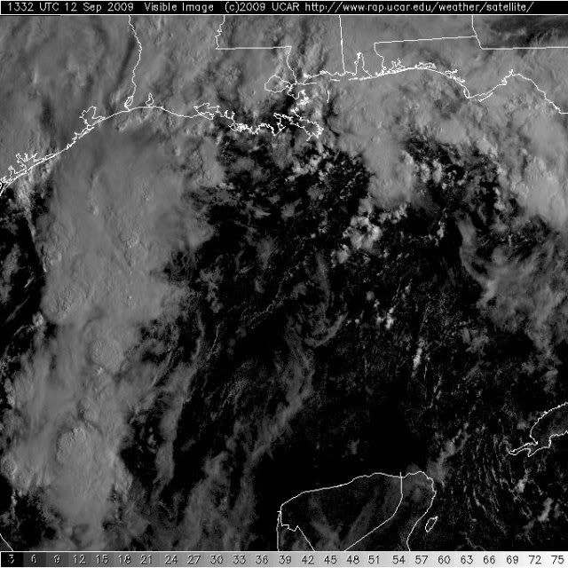
wxman57 wrote:Sat pic of Gulf looks similar to Allison of 2001. Differences are that this low is MUCH weaker, less organized, and closer to the coast. So I don't think it will become a TD before it moves inland. But the rainfall potential for SE TX and SW LA is tremendous.
I want to believe you, I really do, (not flooding totals, just decent totals) but with the first few days of high rain chances so far and nothing but a few spritzes here and there, it's hard to. Of course that doesn't make any difference in what actually happens from here on out, so I hope you're right about a lot of rain. We sure need it. Unless this huge rain event picks up over here, I'll be watering my lawn in a couple of days.
I hope you get some much needed rain as well.
0 likes
-
wxman57
- Moderator-Pro Met
- Posts: 23175
- Age: 68
- Joined: Sat Jun 21, 2003 8:06 pm
- Location: Houston, TX (southwest)
Re: Possible NW Gulf Development Late This Week?
southerngale wrote:wxman57 wrote:Sat pic of Gulf looks similar to Allison of 2001. Differences are that this low is MUCH weaker, less organized, and closer to the coast. So I don't think it will become a TD before it moves inland. But the rainfall potential for SE TX and SW LA is tremendous.
I want to believe you, I really do, (not flooding totals, just decent totals) but with the first few days of high rain chances so far and nothing but a few spritzes here and there, it's hard to. Of course that doesn't make any difference in what actually happens from here on out, so I hope you're right about a lot of rain. We sure need it. Unless this huge rain event picks up over here, I'll be watering my lawn in a couple of days.
I hope you get some much needed rain as well.
The system hasn't moved ashore yet. Rain will move inland when it does.
0 likes
-
cycloneye

- Admin

- Posts: 149505
- Age: 69
- Joined: Thu Oct 10, 2002 10:54 am
- Location: San Juan, Puerto Rico
Re: Possible NW Gulf Development Late This Week?
Recon was cancelled.No surpsise at all and no need to waste money.
WEATHER RECONNAISSANCE FLIGHTS
CARCAH, NATIONAL HURRICANE CENTER, MIAMI, FL.
1000 AM EDT SAT 12 SEPTEMBER 2009
SUBJECT: TROPICAL CYCLONE PLAN OF THE DAY (TCPOD)
VALID 13/1100Z TO 14/1100Z SEPTEMBER 2009
TCPOD NUMBER.....09-107
I. ATLANTIC REQUIREMENTS
1. NEGATIVE RECONNAISSANCE REQUIREMENTS.
2. OUTLOOK FOR SUCCEEDING DAY.....NEGATIVE.
3. REMARK: ALL TASKING REQUIREMENTS FOR GULF
OF MEXICO CANCELED BY NHC AT 12/1220Z.
0 likes


-
gatorcane

- S2K Supporter
- Posts: 23708
- Age: 48
- Joined: Sun Mar 13, 2005 3:54 pm
- Location: Boca Raton, FL
Re: Possible NW Gulf Development Late This Week?
cycloneye wrote:Recon was canceled.No surpsise at all and no need to waste money.
WEATHER RECONNAISSANCE FLIGHTS
CARCAH, NATIONAL HURRICANE CENTER, MIAMI, FL.
1000 AM EDT SAT 12 SEPTEMBER 2009
SUBJECT: TROPICAL CYCLONE PLAN OF THE DAY (TCPOD)
VALID 13/1100Z TO 14/1100Z SEPTEMBER 2009
TCPOD NUMBER.....09-107
I. ATLANTIC REQUIREMENTS
1. NEGATIVE RECONNAISSANCE REQUIREMENTS.
2. OUTLOOK FOR SUCCEEDING DAY.....NEGATIVE.
3. REMARK: ALL TASKING REQUIREMENTS FOR GULF
OF MEXICO CANCELED BY NHC AT 12/1220Z.
Considering the chances of development are likely less than 1% here, I agree with that call.
Last edited by gatorcane on Sat Sep 12, 2009 9:56 am, edited 1 time in total.
0 likes
-
srainhoutx

- S2K Supporter
- Posts: 6919
- Age: 68
- Joined: Sun Jan 14, 2007 11:34 am
- Location: Haywood County, NC
- Contact:
Re: Possible NW Gulf Development Late This Week?
HPC thoughts concerning excessive rainfall...
EXCESSIVE RAINFALL DISCUSSION
NWS HYDROMETEOROLOGICAL PREDICTION CENTER CAMP SPRINGS MD
936 AM EDT SAT SEP 12 2009
...VALID 15Z SAT SEP 12 2009 - 12Z SUN SEP 13 2009...
...REFERENCE AWIPS GRAPHIC UNDER...DAY 1 EXCESSIVE RAINFALL...
SLIGHT RISK OF RAINFALL EXCEEDING FFG TO THE RIGHT OF A LINE FROM
SPS AQR 4F4 ACT ABI SPS.
...SRN PLNS...
VRY STAGNANT PTRN IN PLC WL ALLOW FOR PSBLY SVRL DAYS OF HVY RNFL
THRU THE REGION. LATEST WV IMAGERY SHOWS A BROAD AREA OF MID/UPR
LOW PRES OVR TX WITH SVRL WEAK PERTURBATIONS ROTATG ARND THE MAIN
CIRCULATION CENTER. THE UPR FLOW OVR NRN TO ERN TX SHOWS VRY DIFL
FLOW THAT STRNGTHNS TDA AS AN UPR JET STREAK LIFTS NWD FM THE WRN
GULF AND PROVIDES STGR DEEP LYRD LIFT UNDER THE LEFT EXIT REGION.
SFC ANLYS SHOWS A WEAK LOW ALNG THE CNTRL TX CST THIS MRNG WITH
SVRL WEAK TROFS XTNDG NWD INTO THE SRN PLNS. MSTR REMAINS WELL ABV
SEASONAL NRMLS WITH A LRG REGION OF 2.00-2.25 INCH PWS. THESE
VALUES ARE 1-2 STDS ABV NRML. 8H MSTR FLUX IS NOT THAT GRT...BUT
STILL 1-2 STDS ABV NRML. MDL FCST SOUNDGS SHOW RATHER SMALL...BUT
SKINNY CAPES WITH MOD FLOW THRU A DEEP LYR. PROPAGATION VECTORS FM
THE LATEST GUID SUGGESTS RATHER SLOW STORM MOTIONS WITH CNVCTN
LKLY TRAING ACRS AREAS THRU THE PD. HEATG WL BE AT A PREMIUM TDA
WITH PLENTY OF MID/UPR LVL DEBRIS CLOUDS...BUT ANY BINOVC WL ALLOW
FOR A LCL BOOST IN SFC BASED INSTBLTY/CAPE. THE DEEP MSTR SHLD
EASILY SUPPORT LCLZD TWO INCH PER HR RNFL RATES WITH ISOLD TOTALS
ARND FIVE INCHES BY SUN MRNG.
...TX GULF CST TO WRN FL...
WEAK FNTL BNDRY FM THE CNTRL TX CSTL LOW IS PSTND ALNG THE GULF
CST AND ACRS NRN FL THIS MRNG AND SHLD MOV VRY LITTLE THIS PD.
MSTR CVRG WL BE MAXIMIZED ALNG THIS BNDRY THRU THE PD WITH
PERIODIC FLAREUPS IN CNVCTN. MSTR IS VRY DEEP WITH A SWATH OF PWS
OF 2.00-2.50 INCHES. UPR FLOW IS SLGTLY DIFL WITH SOME MID/UPR
SHRTWV ENERGY LIFTG OVR THE REGION. ALTHOU FFG VALUES ARE QUITE HI
IN THIS AREA...CNVCTN COULD BCM ANCHORED ALNG THE BNDRY. THIS
COULD RESULT IN LCLZD 2-3 INCH RNFL RATES ALNG THE CSTL AREAS INTO
THIS AFTN/TNGT THAT WL RESULT IN PONDG/RUNOFF ISSUES...ESPCLY IN
URBAN AREAS.
ECKERT
0 likes
-
HouTXmetro

- Category 5

- Posts: 3949
- Joined: Sun Jun 13, 2004 6:00 pm
- Location: District of Columbia, USA
Re: Possible NW Gulf Development Late This Week?
Interesting, convection consolidating but staying off coast.
http://radar.weather.gov/radar.php?prod ... x&loop=yes
http://radar.weather.gov/radar.php?prod ... x&loop=yes
0 likes
-
srainhoutx
- S2K Supporter
- Posts: 6919
- Age: 68
- Joined: Sun Jan 14, 2007 11:34 am
- Location: Haywood County, NC
- Contact:
Re: Possible NW Gulf Development Late This Week?
SPC thoughts this morning. I believe many have expexted this to be a potential flooding threat for many days whether tropical development or not. Regardless it is a very complicated setup.
DAY 1 CONVECTIVE OUTLOOK
NWS STORM PREDICTION CENTER NORMAN OK
0745 AM CDT SAT SEP 12 2009
VALID 121300Z - 131200Z
...NO SVR TSTM AREAS FORECAST...
...SYNOPSIS...
UNUSUAL PATTERN OVER THE LWR 48 THIS PERIOD...WITH A SLOWLY
RETROGRESSIVE LOW OVER THE NRN PLNS AND A BROADER...NEARLY STNRY
CIRCULATION CENTERED OVER CNTRL TX. THE TX LOW MAY DEEPEN SOMEWHAT
THROUGH THE PERIOD...RESULTING IN SLIGHTLY INCREASED MID/UPR LVL
FLOW ATOP VERY RICH MOISTURE OVER THE SRN PLNS/GULF STATES.
...SE TX/SRN LA TO CNTRL GULF CST...
CURRENT SFC ANALYSIS SHOWS A WEAK WARM/STNRY FRONT EXTENDING
GENERALLY E ACROSS THE NRN GULF OF MEX AND CNTRL FL FROM A 1006 MB
LOW E OF CRP. A WEAK WAVE ALONG THE BOUNDARY IS APPARENT IN THE
STREAMLINE FIELD S OF BVE. EXPECT THAT THE FRONT WILL MOVE ONLY
VERY SLOWLY N TODAY GIVEN PERSISTENT ENELY SFC FLOW OVER THE GULF
CST STATES...LIMITED PRESSURE FALLS N OF BOUNDARY...AND CONTINUED
ELEVATED RAIN SHOWERS/THUNDER OVER THE REGION. THE WRN PART OF THE
BOUNDARY SHOULD...HOWEVER...MOVE NWD INTO SE TX AND SRN LA
TONIGHT/EARLY SUN AS UPR CIRCULATION SLOWLY STRENGTHENS...AND WAVE
NOW NEAR BVE MOVES E TOWARD THE FL CSTL BEND.
THE FRONT SHOULD SERVE AS A FOCUS FOR FAIRLY WIDESPREAD SHOWER/STORM
DEVELOPMENT OVER THE GULF REGION THROUGH THE PERIOD. WHILE LOW TO
MID LVL LAPSE RATES WILL REMAIN WEAK...NWD MOTION OF FRONT WILL
ALLOW WARMER AND VERY MOIST AIR /PW AOA 2.25 INCHES WITH SFC
DEWPOINTS IN THE MID 70S F/ TO SPREAD INLAND FROM SE TX INTO SRN LA
AND...WITH TIME...PERHAPS INTO SRN MS/AL. COUPLED WITH WEAKLY
CONVERGENT LOW LVL WIND FIELD AND MODEST BUT STRENGTHENING SW FLOW
ALOFT...LOW LVL VEERING PROFILES NEAR BOUNDARY MAY PROVE SUFFICIENT
TO SUPPORT A FEW STORMS WITH LOW LVL ROTATION. THE MORE SUSTAINED
AND/OR DISCRETE CELLS MAY POSE A LOW PROBABILISTIC TORNADO OR
LOCALLY DMG WIND THREAT LATER THIS AFTN THROUGH EARLY SUN.
..CORFIDI/HURLBUT.. 09/12/2009
0 likes

-
wxman57
- Moderator-Pro Met
- Posts: 23175
- Age: 68
- Joined: Sat Jun 21, 2003 8:06 pm
- Location: Houston, TX (southwest)
Re: Possible NW Gulf Development Late This Week?
It is very unlikely that this system will become a TD/TS with the low center almost on the coast near Matagorda Bay as of 10AM. Development has never been likely. But the tremendous amount of moisture streaming northward toward the upper TX coast and LA coast could mean rainfall across a large area of 5-10 inches, with some spots receiving 15-20 inches. I'd say that's a pretty big deal.
0 likes
-
attallaman
Re: Possible NW Gulf Development Late This Week?
I'll have to agree wxman57.wxman57 wrote:It is very unlikely that this system will become a TD/TS with the low center almost on the coast near Matagorda Bay as of 10AM. Development has never been likely. But the tremendous amount of moisture streaming northward toward the upper TX coast and LA coast could mean rainfall across a large area of 5-10 inches, with some spots receiving 15-20 inches. I'd say that's a pretty big deal.
0 likes
-
srainhoutx
- S2K Supporter
- Posts: 6919
- Age: 68
- Joined: Sun Jan 14, 2007 11:34 am
- Location: Haywood County, NC
- Contact:
Re: Possible NW Gulf Development Late This Week?
wxman57 wrote:It is very unlikely that this system will become a TD/TS with the low center almost on the coast near Matagorda Bay as of 10AM. Development has never been likely. But the tremendous amount of moisture streaming northward toward the upper TX coast and LA coast could mean rainfall across a large area of 5-10 inches, with some spots receiving 15-20 inches. I'd say that's a pretty big deal.
Exactly my thoughts!
0 likes
 [/img]
-
srainhoutx
- S2K Supporter
- Posts: 6919
- Age: 68
- Joined: Sun Jan 14, 2007 11:34 am
- Location: Haywood County, NC
- Contact:
Re: Possible NW Gulf Development Late This Week?
Regional Radar is very interesting with all the dynamics at play with this complex setup...
http://radar.weather.gov/Conus/southpla ... e_loop.php
http://radar.weather.gov/Conus/southpla ... e_loop.php
0 likes

Re: Possible NW Gulf Development Late This Week?
Fox Houston radar shows some red cells coming in off the Gulf now at Bolivar Peninsula, Galveston, and east of Freeport...maybe the rains will now commence! Got my fingers crossed.
http://www.myfoxhoustonlive.com/
http://www.myfoxhoustonlive.com/
0 likes