NOAA EPAC outlook is above average.
15-22 named storms,
•7-12 hurricanes,
•5-8 major hurricanes,
•An ACE range 110%-190% of the median.
http://www.cpc.ncep.noaa.gov/products/E ... icane.html
2015 EPAC Season
Moderator: S2k Moderators
Forum rules

The posts in this forum are NOT official forecasts and should not be used as such. They are just the opinion of the poster and may or may not be backed by sound meteorological data. They are NOT endorsed by any professional institution or STORM2K. For official information, please refer to products from the National Hurricane Center and National Weather Service.
-
cycloneye

- Admin

- Posts: 148725
- Age: 69
- Joined: Thu Oct 10, 2002 10:54 am
- Location: San Juan, Puerto Rico
Re: 2015 EPAC Season
0 likes
Visit the Caribbean-Central America Weather Thread where you can find at first post web cams,radars
and observations from Caribbean basin members Click Here
and observations from Caribbean basin members Click Here
-
Yellow Evan

- Professional-Met

- Posts: 16212
- Age: 27
- Joined: Fri Jul 15, 2011 12:48 pm
- Location: Henderson, Nevada/Honolulu, HI
- Contact:
Re: 2015 EPAC Season
cycloneye wrote:NOAA EPAC outlook is above average.
15-22 named storms,
•7-12 hurricanes,
•5-8 major hurricanes,
•An ACE range 110%-190% of the median.
http://www.cpc.ncep.noaa.gov/products/E ... icane.html
Pretty much talks about the same positive factors I've been talking about for quite a bit. No surprise here.
0 likes
-
Yellow Evan
- Professional-Met
- Posts: 16212
- Age: 27
- Joined: Fri Jul 15, 2011 12:48 pm
- Location: Henderson, Nevada/Honolulu, HI
- Contact:
Re:
CrazyC83 wrote:IMO those numbers are conservative, but they make sense.
They aren't conservative IMO and within range of most moderate to strong Ninos.
0 likes
-
tolakram
- Admin
- Posts: 20168
- Age: 62
- Joined: Sun Aug 27, 2006 8:23 pm
- Location: Florence, KY (name is Mark)
Re: 2015 EPAC Season
Posted this in the 92E thread, reposting here.
If the second storm exists it appears to take shape in 72 - 96 hours.
96 hours

Model Images
120 hours
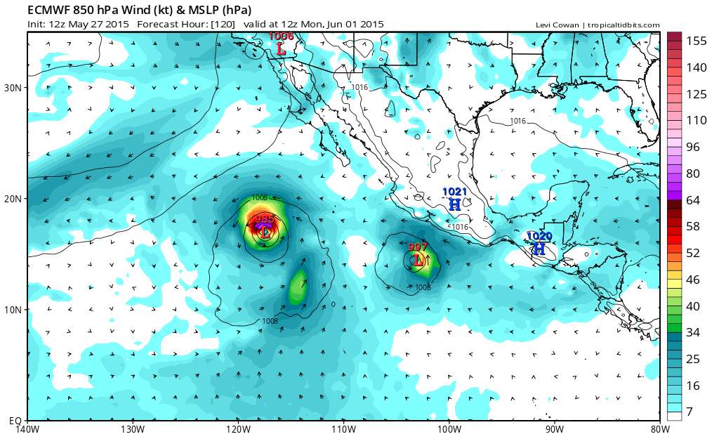
192 hours
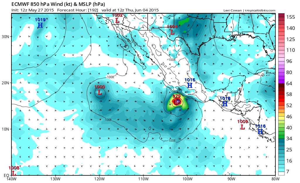
I suppose two distinct storms is looking a little more feasible?
If the second storm exists it appears to take shape in 72 - 96 hours.
96 hours
Model Images
120 hours
192 hours
I suppose two distinct storms is looking a little more feasible?
0 likes
M a r k
- - - - -
Join us in chat: Storm2K Chatroom Invite. Android and IOS apps also available.
The posts in this forum are NOT official forecasts and should not be used as such. Posts are NOT endorsed by any professional institution or STORM2K.org. For official information and forecasts, please refer to NHC and NWS products.
-
cycloneye
- Admin
- Posts: 148725
- Age: 69
- Joined: Thu Oct 10, 2002 10:54 am
- Location: San Juan, Puerto Rico
Re: 2015 EPAC Season
And just like that Yellow Evan,NHC mentions the Euro one.
An area of disturbed weather located several hundred miles south of
the Gulf of Tehuantepec is associated with a tropical wave.
Environment conditions could become more favorable for some
development of this system by the weekend while it moves slowly to
the west-northwest.
* Formation chance through 48 hours...low...near 0 percent
* Formation chance through 5 days...low...20 percent
0 likes
Visit the Caribbean-Central America Weather Thread where you can find at first post web cams,radars
and observations from Caribbean basin members Click Here
and observations from Caribbean basin members Click Here
-
Yellow Evan
- Professional-Met
- Posts: 16212
- Age: 27
- Joined: Fri Jul 15, 2011 12:48 pm
- Location: Henderson, Nevada/Honolulu, HI
- Contact:
Re: 2015 EPAC Season
cycloneye wrote:And just like that Yellow Evan,NHC mentions the Euro one.
An area of disturbed weather located several hundred miles south of
the Gulf of Tehuantepec is associated with a tropical wave.
Environment conditions could become more favorable for some
development of this system by the weekend while it moves slowly to
the west-northwest.
* Formation chance through 48 hours...low...near 0 percent
* Formation chance through 5 days...low...20 percent
No surprise, since the GFS is hinting at it.
0 likes
-
Yellow Evan
- Professional-Met
- Posts: 16212
- Age: 27
- Joined: Fri Jul 15, 2011 12:48 pm
- Location: Henderson, Nevada/Honolulu, HI
- Contact:

-
Yellow Evan
- Professional-Met
- Posts: 16212
- Age: 27
- Joined: Fri Jul 15, 2011 12:48 pm
- Location: Henderson, Nevada/Honolulu, HI
- Contact:
Re: 2015 EPAC Season

[img]http://i59.tinypic.com/29a80y.png][/img]
NOGAPS develops the 0/20 and also a thing SW of 92E

GFS Ensemble support on the rise for the 0/20.
Last edited by Yellow Evan on Thu May 28, 2015 2:17 pm, edited 1 time in total.
0 likes
-
Yellow Evan
- Professional-Met
- Posts: 16212
- Age: 27
- Joined: Fri Jul 15, 2011 12:48 pm
- Location: Henderson, Nevada/Honolulu, HI
- Contact:
2. An area of disturbed weather located several hundred miles south of
the Gulf of Tehuantepec is associated with a tropical wave.
Environment conditions could become more favorable for some
development of this system by the weekend while it moves slowly to
the west-northwest.
* Formation chance through 48 hours...low...near 0 percent
* Formation chance through 5 days...low...20 percent
0 likes
-
Yellow Evan
- Professional-Met
- Posts: 16212
- Age: 27
- Joined: Fri Jul 15, 2011 12:48 pm
- Location: Henderson, Nevada/Honolulu, HI
- Contact:
Re: 2015 EPAC Season


Blanca, Carlos, Delores. Watch out EPAC, showing this and it's only June?
0 likes
-
dexterlabio
- Category 5

- Posts: 3499
- Joined: Sat Oct 24, 2009 11:50 pm
Re: 2015 EPAC Season
It's interesting that this basin seems to be feeling the "El Nino effect" like the WPAC. Let's see if we can see a major emerging out of these potential systems. Of course I am hoping for a safe hurricane season. (Though the pattern during El Nino is that cyclones tend to get picked up by the trough and move NE hitting landmass isn't it?)
0 likes
Personal Forecast Disclaimer:
The posts in this forum are NOT official forecast and should not be used as such. They are just the opinion of the poster and may or may not be backed by sound meteorological data. They are NOT endorsed by any professional institution or storm2k.org. For official information, please refer to the NHC and NWS products.
The posts in this forum are NOT official forecast and should not be used as such. They are just the opinion of the poster and may or may not be backed by sound meteorological data. They are NOT endorsed by any professional institution or storm2k.org. For official information, please refer to the NHC and NWS products.
-
cycloneye
- Admin
- Posts: 148725
- Age: 69
- Joined: Thu Oct 10, 2002 10:54 am
- Location: San Juan, Puerto Rico
Re: 2015 EPAC Season
dexterlabio wrote:It's interesting that this basin seems to be feeling the "El Nino effect" like the WPAC. Let's see if we can see a major emerging out of these potential systems. Of course I am hoping for a safe hurricane season. (Though the pattern during El Nino is that cyclones tend to get picked up by the trough and move NE hitting landmass isn't it?)
But at least Andres looks like it will stay in open waters however what will form behind (0/20) may be a threat.
0 likes
Visit the Caribbean-Central America Weather Thread where you can find at first post web cams,radars
and observations from Caribbean basin members Click Here
and observations from Caribbean basin members Click Here
-
Yellow Evan
- Professional-Met
- Posts: 16212
- Age: 27
- Joined: Fri Jul 15, 2011 12:48 pm
- Location: Henderson, Nevada/Honolulu, HI
- Contact:
Re: 2015 EPAC Season
dexterlabio wrote:It's interesting that this basin seems to be feeling the "El Nino effect" like the WPAC. Let's see if we can see a major emerging out of these potential systems. Of course I am hoping for a safe hurricane season. (Though the pattern during El Nino is that cyclones tend to get picked up by the trough and move NE hitting landmass isn't it?)
Not necessarily. It's just that landfalls tend to be stronger.
0 likes
-
cycloneye
- Admin
- Posts: 148725
- Age: 69
- Joined: Thu Oct 10, 2002 10:54 am
- Location: San Juan, Puerto Rico
Re: 2015 EPAC Season
11 AM PDT:
A small area of disorganized showers and a few thunderstorms
associated with a tropical wave is located several hundred miles
south-southwest of the Gulf of Tehuantepec. Some gradual development
of this system is possible early next week while it moves slowly
west-northwestward.
* Formation chance through 48 hours...low...near 0 percent
* Formation chance through 5 days...low...20 percent
0 likes
Visit the Caribbean-Central America Weather Thread where you can find at first post web cams,radars
and observations from Caribbean basin members Click Here
and observations from Caribbean basin members Click Here
-
cycloneye
- Admin
- Posts: 148725
- Age: 69
- Joined: Thu Oct 10, 2002 10:54 am
- Location: San Juan, Puerto Rico
Re: 2015 EPAC Season
12z Euro has 0/20 making landfall at 240 hours near Puerto Vallarta.

0 likes
Visit the Caribbean-Central America Weather Thread where you can find at first post web cams,radars
and observations from Caribbean basin members Click Here
and observations from Caribbean basin members Click Here
-
Kingarabian

- S2K Supporter

- Posts: 16294
- Joined: Sat Aug 08, 2009 3:06 am
- Location: Honolulu, Hawaii
-
Yellow Evan
- Professional-Met
- Posts: 16212
- Age: 27
- Joined: Fri Jul 15, 2011 12:48 pm
- Location: Henderson, Nevada/Honolulu, HI
- Contact:
Re: 2015 EPAC Season


GFS liking the long-range, but keep in mind it tends to overdue long-range systems during an MJO pulse.
0 likes
-
cycloneye
- Admin
- Posts: 148725
- Age: 69
- Joined: Thu Oct 10, 2002 10:54 am
- Location: San Juan, Puerto Rico
Re: 2015 EPAC Season
Yikes! 18z GFS bombs 0/20 to 933 mbs.

0 likes
Visit the Caribbean-Central America Weather Thread where you can find at first post web cams,radars
and observations from Caribbean basin members Click Here
and observations from Caribbean basin members Click Here
-
Yellow Evan
- Professional-Met
- Posts: 16212
- Age: 27
- Joined: Fri Jul 15, 2011 12:48 pm
- Location: Henderson, Nevada/Honolulu, HI
- Contact:

Who is online
Users browsing this forum: cycloneye, Google [Bot] and 58 guests