2017 indicators: SST's / MSLP / SAL / Steering / Instability
Moderator: S2k Moderators
Forum rules

The posts in this forum are NOT official forecasts and should not be used as such. They are just the opinion of the poster and may or may not be backed by sound meteorological data. They are NOT endorsed by any professional institution or STORM2K. For official information, please refer to products from the National Hurricane Center and National Weather Service.
-
Hurricaneman

- Category 5

- Posts: 7404
- Age: 45
- Joined: Tue Aug 31, 2004 3:24 pm
- Location: central florida
Re: 2017 indicators: SST's / MSLP / SAL / Steering / Instability
Could be a new analog for future seasons
1 likes
-
cycloneye

- Admin

- Posts: 149275
- Age: 69
- Joined: Thu Oct 10, 2002 10:54 am
- Location: San Juan, Puerto Rico
Re: 2017 indicators: SST's / MSLP / SAL / Steering / Instability
0 likes
Visit the Caribbean-Central America Weather Thread where you can find at first post web cams,radars
and observations from Caribbean basin members Click Here
and observations from Caribbean basin members Click Here
-
tarheelprogrammer

- S2K Supporter

- Posts: 1793
- Joined: Mon Mar 28, 2016 9:25 pm
- Location: Raleigh, NC area (Garner, NC)
Re: 2017 indicators: SST's / MSLP / SAL / Steering / Instability
What exactly could this mean for the Atlantic season?
0 likes
My posts are not official forecasts. They are just my opinion and may or may not be backed by sound meteorological data. They are NOT endorsed by any professional institution or storm2k.org. For official information, please refer to the NHC and NWS products.
-
Hurricaneman
- Category 5
- Posts: 7404
- Age: 45
- Joined: Tue Aug 31, 2004 3:24 pm
- Location: central florida
Re: 2017 indicators: SST's / MSLP / SAL / Steering / Instability
It would displace the azores high farther west closer to Bermuda which would cause for lower pressure in th MDR I would think and that could spell trouble if that Bermuda/azores high is in that position causing any developing wave west of 40W to head WNW towards the lesser Antilles,and if north of the islands a path towards the US mainland and if the high is weaker the east coast to eastern GOM and if stronger through Florida right to possibly Texas so that's something that will need to be watched
3 likes

Re: 2017 indicators: SST's / MSLP / SAL / Steering / Instability
Wow, look at the latest SST Anomaly! Very interesting how much the MDR has warmed in a month, especially off of Cape Verde  . The waters in the West Atlantic and the Southern Caribbean are also warming nicely as well. Even some cooler than normal temperatures in the Niño 3 region.

0 likes
Igor 2010, Sandy 2012, Fay 2014, Gonzalo 2014, Joaquin 2015, Nicole 2016, Humberto 2019, Imelda 2025
I am only a tropical weather enthusiast. My predictions are not official and may or may not be backed by sound meteorological data. For official information, please refer to the NHC and NWS products.
I am only a tropical weather enthusiast. My predictions are not official and may or may not be backed by sound meteorological data. For official information, please refer to the NHC and NWS products.
-
tatertawt24
- Category 1

- Posts: 309
- Joined: Wed Oct 24, 2012 12:57 pm
Re: 2017 indicators: SST's / MSLP / SAL / Steering / Instability
Kazmit_ wrote:Wow, look at the latest SST Anomaly! Very interesting how much the MDR has warmed in a month, especially off of Cape Verde
That straight ripple of hot SST's off the coast of Ecuador is too cool!
0 likes
Personal Forecast Disclaimer:
The posts in this forum are NOT official forecast and should not be used as such. They are just the opinion of the poster and may or may not be backed by sound meteorological data. They are NOT endorsed by any professional institution or storm2k.org. For official information, please refer to the NHC and NWS products.
The posts in this forum are NOT official forecast and should not be used as such. They are just the opinion of the poster and may or may not be backed by sound meteorological data. They are NOT endorsed by any professional institution or storm2k.org. For official information, please refer to the NHC and NWS products.
-
Hurricaneman
- Category 5
- Posts: 7404
- Age: 45
- Joined: Tue Aug 31, 2004 3:24 pm
- Location: central florida
Re: 2017 indicators: SST's / MSLP / SAL / Steering / Instability
What's he's saying here is that this is a pattern where major hurricanes hit the US and what he's saying makes sense as it seems the lowest pressures are going to be in the tropics where the last 11 years the lowest pressures have been in the subtropics and that leads to weakening hurricanes as they don't have that gradient to strengthen to landfall but this year looks quite the opposite
0 likes
-
TheAustinMan

- Category 5
- Posts: 1060
- Joined: Mon Jul 08, 2013 4:26 pm
- Location: Central TX / United States
Re: 2017 indicators: SST's / MSLP / SAL / Steering / Instability
Hurricaneman wrote:What's he's saying here is that this is a pattern where major hurricanes hit the US and what he's saying makes sense as it seems the lowest pressures are going to be in the tropics where the last 11 years the lowest pressures have been in the subtropics and that leads to weakening hurricanes as they don't have that gradient to strengthen to landfall but this year looks quite the opposite
Didn't 2013 also have lower sea-level pressures in the tropics for the August/September/October trimonthly period? From the looks of things the Euro MSLP forecast for this year looks to be a change from the last few years, but I don't find the Euro's 2017 forecast that unique when considering the last 11 years.
What I'd be more interested in, with regard to US hurricane strikes, are the 500mb height anomalies. Here's the last 11 years, for reference. The presence of anomalous troughing on the east coast has luckily acted as a sort of shield, and I'm curious if that anomaly maintains this season, or if we see a continuation of last year's east coast ridging.
Last edited by TheAustinMan on Sun May 14, 2017 9:54 pm, edited 1 time in total.
1 likes
Treat my opinions with a grain of salt. For official information see your local weather service.
“It's tough to make predictions, especially about the future.”
“It's tough to make predictions, especially about the future.”
-
Hurricaneman
- Category 5
- Posts: 7404
- Age: 45
- Joined: Tue Aug 31, 2004 3:24 pm
- Location: central florida
Re: 2017 indicators: SST's / MSLP / SAL / Steering / Instability
Joe Bastardi may be right or could be full of something that has yet to be determined but we'll see in November
0 likes
-
cycloneye
- Admin
- Posts: 149275
- Age: 69
- Joined: Thu Oct 10, 2002 10:54 am
- Location: San Juan, Puerto Rico
Re: 2017 indicators: SST's / MSLP / SAL / Steering / Instability
Here is the MSLP ECMWF May chart for ASO that all are talking about and is made public on this May 15.
Is really a big change from the past updates.
May 15 Update


April 15 update


Is really a big change from the past updates.
May 15 Update
April 15 update
0 likes
Visit the Caribbean-Central America Weather Thread where you can find at first post web cams,radars
and observations from Caribbean basin members Click Here
and observations from Caribbean basin members Click Here

Re: 2017 indicators: SST's / MSLP / SAL / Steering / Instability
Another comparison chart to previous run on precipitation forecast.
May 15 update
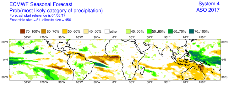
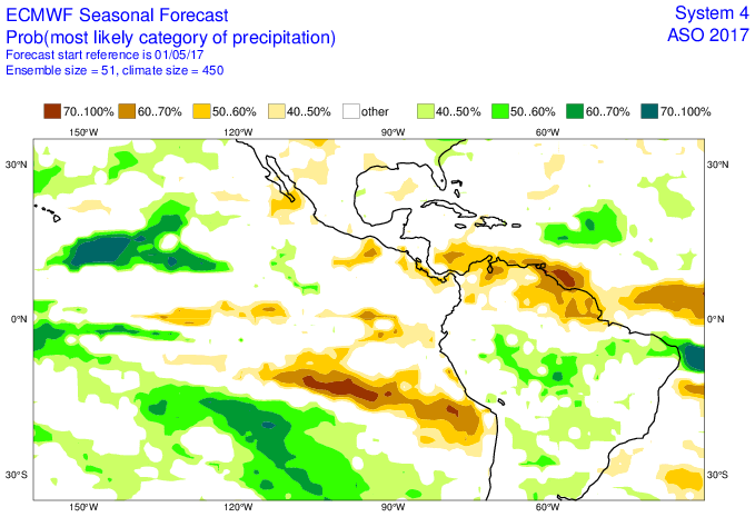
April 15 update
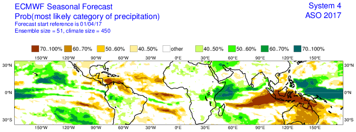
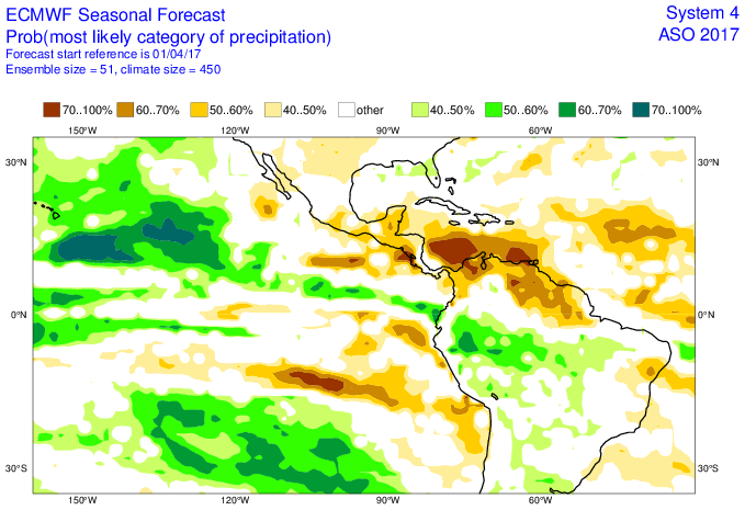
May 15 update
April 15 update
0 likes
-
TheStormExpert
Re: 2017 indicators: SST's / MSLP / SAL / Steering / Instability
What a HUGE difference a month makes! Also looking as if conditions might not be quite as favorable as forecasted last month come peak season for the area surrounding Hawaii.
0 likes

Re: 2017 indicators: SST's / MSLP / SAL / Steering / Instability
the highest precip anomaly for the EPAC is near Hawaii. It's still favorable there
0 likes
-
TheStormExpert
Re: 2017 indicators: SST's / MSLP / SAL / Steering / Instability
Alyono wrote:the highest precip anomaly for the EPAC is near Hawaii. It's still favorable there
Still favorable, just not as favorable as forecasted last month. Would this be typical of a Modoki El Niño?
0 likes


Re: 2017 indicators: SST's / MSLP / SAL / Steering / Instability
TheStormExpert wrote:Alyono wrote:the highest precip anomaly for the EPAC is near Hawaii. It's still favorable there
Still favorable, just not as favorable as forecasted last month. Would this be typical of a Modoki El Niño?
A true modoki would favor even further west, near the dateline moving towards the WPAC. Hawaii and east, SE is still EPAC MDR
0 likes
The above post and any post by Ntxw is NOT an official forecast and should not be used as such. It is just the opinion of the poster and may or may not be backed by sound meteorological data. It is NOT endorsed by any professional institution including Storm2k. For official information, please refer to NWS products.
Help support Storm2K!
-
tarheelprogrammer
- S2K Supporter
- Posts: 1793
- Joined: Mon Mar 28, 2016 9:25 pm
- Location: Raleigh, NC area (Garner, NC)
Re: 2017 indicators: SST's / MSLP / SAL / Steering / Instability
https://twitter.com/TropicalTidbits/status/864170778748760064
https://twitter.com/TropicalTidbits/status/864170836466520065
https://twitter.com/TropicalTidbits/status/864170892372455426
https://twitter.com/TropicalTidbits/status/864170944599818240
https://twitter.com/TropicalTidbits/status/864171001290129412
https://twitter.com/TropicalTidbits/status/864171772203216900
https://twitter.com/TropicalTidbits/status/864171962976874496
0 likes
My posts are not official forecasts. They are just my opinion and may or may not be backed by sound meteorological data. They are NOT endorsed by any professional institution or storm2k.org. For official information, please refer to the NHC and NWS products.
Re: 2017 indicators: SST's / MSLP / SAL / Steering / Instability
1 likes
The above post and any post by Ntxw is NOT an official forecast and should not be used as such. It is just the opinion of the poster and may or may not be backed by sound meteorological data. It is NOT endorsed by any professional institution including Storm2k. For official information, please refer to NWS products.
Help support Storm2K!
Help support Storm2K!
-
Andrew92

- S2K Supporter
- Posts: 3247
- Age: 42
- Joined: Mon Jun 16, 2003 12:35 am
- Location: Phoenix, Arizona
Re: 2017 indicators: SST's / MSLP / SAL / Steering / Instability
The JB tweet above has me quite concerned when coupled with a theory I have proposed for some time. Some people may know that the theory is the second year following a traditional El Nino has always seen a major hurricane hit the US. A major hurricane in my case is not merely a Category 3 or higher by wind, but instead I go by pressure. The threshold is below 965 mb. 2017 is going to test that theory.
What's more is that El Nino may indeed not be returning as speculated just a month ago or so. I am not going to necessarily say though that 2005 is a solid analog. However, the MDR was not terribly active that year after July (when we had Dennis and Emily) and such a weak MDR would not surprise me again this year. That's because, even without an El Nino, some warming may keep the lower latitudes at bay a little bit. But the subtropics concern me a great deal more. Wasn't there also a lot of talk of potential homegrown activity this year? The Bahamas and Gulf of Mexico fit that bill well, so such activity forming and intensifying in those regions is probably what I would most expect.
I agree there is a lot of uncertainty and mixed signals coming into this hurricane season as well. But the theory of the second year after an El Nino stands to be tested. Everyone should absolutely watch out this year for a big one to potentially hit. (I know that sounds cliche, but this year, based on my theory, is high-risk.) And I should stress, it won't take 2005-like impacts to prove the theory. It will only take one hurricane below 965 mb striking the US coast somewhere for the theory to stand. Just like last time, in 2011, when Irene was the only one, but her pressure was 955 mb at the North Carolina landfall, and she went on to cause a lot of problems and damage in the Northeast.
I hope it's proven wrong, but I would be well-prepared if I lived on the Atlantic coast.
-Andrew92
2 likes
-
Kingarabian

- S2K Supporter
- Posts: 16348
- Joined: Sat Aug 08, 2009 3:06 am
- Location: Honolulu, Hawaii
Re: 2017 indicators: SST's / MSLP / SAL / Steering / Instability
Alyono wrote:the highest precip anomaly for the EPAC is near Hawaii. It's still favorable there
With the anomalously high SST's near Hawaii, it tells me we are already seeing lower than normal pressures in the vicinity of Hawaii and it's only May. And if you factor in a warm neutral/weak El-Nino to keep shear favorable, I would definitely say we'll see higher than normal activity for Hawaii.
The CPAC is tricky to forecast so it's hard to say how much storms it will spawn. But look for some classic CPAC-WPAC crosser's. And we'll definitely see a plethora of EPAC-CPAC crosser's.
0 likes
RIP Kobe Bryant
Who is online
Users browsing this forum: TeamPlayersBlue and 66 guests