Weak low in NE Gulf of Mexico: (Is Invest 95L)

This is the general tropical discussion area. Anyone can take their shot at predicting a storms path.

Moderator: S2k Moderators

Forum rules

The posts in this forum are NOT official forecasts and should not be used as such. They are just the opinion of the poster and may or may not be backed by sound meteorological data. They are NOT endorsed by any professional institution or STORM2K. For official information, please refer to products from the National Hurricane Center and National Weather Service.

Help Support Storm2K
Message
Author
User avatar
Steve
S2K Supporter
S2K Supporter
Posts: 9621
Joined: Sat Apr 05, 2003 11:41 pm
Location: Not a state-caster

Re: Weak low in NE Gulf of Mexico

#341 Postby Steve » Thu Jul 30, 2015 2:20 pm

NDG wrote:12z ECMWF (aggressive Euro) develops a weak TD south of the MS River in 48 hrs, tracks it north immediately inland by Sunday afternoon.


That's where the 00z Canadian/CMC/GEM is if is even an actual depression. Same thing with the 12z. GFS is a little further west with the energy. Canadian had this down if it verifies. GFS probably backs the energy too far west, but if it dips farther south/southwest than indicated by the ECMWF and CMC, it could be right.

Many will note that people have been talking about looking south of this current front for at least a week. Patterns have foretold the place to look coupled with the El Nino/Progressive pattern stating that a split was more or less out of the question, and as noted last night, just a piece of energy gets left behind. As fast as they have it, it sort of tails behind what would be the front coming back up as a warm front as the airmass behind it lifts out to the NE. Could be a rainy few days I guess. QPF (which I believe is run off the GFS) still keeps the bulk of the rain in two spots - off the mouth of the river and off the Big Bend in the 5-7 day totals. The difference is that the 2 day range has most of the rain south of the mouth of the MS River, and later in the 7 day period has the bulk off the FL Coast.
http://www.wpc.ncep.noaa.gov/qpf/day1-7.shtml
Last edited by Steve on Thu Jul 30, 2015 2:25 pm, edited 1 time in total.
0 likes   

User avatar
Steve
S2K Supporter
S2K Supporter
Posts: 9621
Joined: Sat Apr 05, 2003 11:41 pm
Location: Not a state-caster

#342 Postby Steve » Thu Jul 30, 2015 2:25 pm

Then it looks like the high-res NAM is more in line with the GFS splitting the energy along the surface trough where a piece sort of heads to the NW Gulf and dissipates then cyclonic turning near Florida lifts out with the front. This would be more in line with what the QPF is showing.

Regular NAM (simulated radar) is pretty much the same, except it appears to show a tightening low in the SW Atlantic after the energy crosses Florida and gets out there. It looks like the front out ahead of it sort of washes out and a new wave or spin forms in the wake.
0 likes   

NCSTORMMAN

#343 Postby NCSTORMMAN » Thu Jul 30, 2015 2:39 pm

I personally think a storm is forming as we speak right below Louisiana and I see the lower level circulation going south away from Mississippi/Alabama border. Just my personal opinion. Shear seems like it is relaxing because I am not seeing the clouds being blown away like the last few days (at least in the G.O.M). Could I be wrong? Yes, I could be and I am not a weatherman but it is just a gut feeling.
0 likes   

User avatar
NDG
S2K Supporter
S2K Supporter
Posts: 15446
Joined: Sun Jul 09, 2006 10:14 pm
Location: Orlando, FL

Re:

#344 Postby NDG » Thu Jul 30, 2015 3:01 pm

NCSTORMMAN wrote:I personally think a storm is forming as we speak right below Louisiana and I see the lower level circulation going south away from Mississippi/Alabama border. Just my personal opinion. Shear seems like it is relaxing because I am not seeing the clouds being blown away like the last few days (at least in the G.O.M). Could I be wrong? Yes, I could be and I am not a weatherman but it is just a gut feeling.


Vorticity is mostly above the surface at this time, based on surface reports. Give it 24-48 hrs, at least.
0 likes   

NCSTORMMAN

Re: Re:

#345 Postby NCSTORMMAN » Thu Jul 30, 2015 3:04 pm

NDG wrote:
NCSTORMMAN wrote:I personally think a storm is forming as we speak right below Louisiana and I see the lower level circulation going south away from Mississippi/Alabama border. Just my personal opinion. Shear seems like it is relaxing because I am not seeing the clouds being blown away like the last few days (at least in the G.O.M). Could I be wrong? Yes, I could be and I am not a weatherman but it is just a gut feeling.


Vorticity is mostly above the surface at this time, based on surface reports. Give it 24-48 hrs, at least.


Okay there are a lot more knowledgeable people than me on here and I am but a simple man. I seen the earth wind map and thought that was representing lower level spin.
0 likes   

User avatar
NDG
S2K Supporter
S2K Supporter
Posts: 15446
Joined: Sun Jul 09, 2006 10:14 pm
Location: Orlando, FL

#346 Postby NDG » Thu Jul 30, 2015 3:07 pm

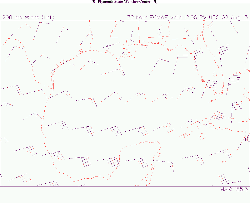
12z Euro forecasts better upper level conditions for the north central GOM by this weekend, so perhaps the Euro's forecast will pan out this time.

Image
Last edited by NDG on Thu Jul 30, 2015 3:16 pm, edited 1 time in total.
0 likes   

User avatar
NDG
S2K Supporter
S2K Supporter
Posts: 15446
Joined: Sun Jul 09, 2006 10:14 pm
Location: Orlando, FL

Re: Re:

#347 Postby NDG » Thu Jul 30, 2015 3:09 pm

NCSTORMMAN wrote:
NDG wrote:
NCSTORMMAN wrote:I personally think a storm is forming as we speak right below Louisiana and I see the lower level circulation going south away from Mississippi/Alabama border. Just my personal opinion. Shear seems like it is relaxing because I am not seeing the clouds being blown away like the last few days (at least in the G.O.M). Could I be wrong? Yes, I could be and I am not a weatherman but it is just a gut feeling.


Vorticity is mostly above the surface at this time, based on surface reports. Give it 24-48 hrs, at least.


Okay there are a lot more knowledgeable people than me on here and I am but a simple man. I seen the earth wind map and thought that was representing lower level spin.


Don't get me wrong, there is a broad circulation overall along with a surface trough but a closed well defined circulation has not formed yet, IMO.
0 likes   

NCSTORMMAN

Re: Re:

#348 Postby NCSTORMMAN » Thu Jul 30, 2015 3:11 pm

NDG,

You are one of the chosen few I trust on this board and followed a lot of what you have said the past few years reading this board. So, if you say so then it is unless proven otherwise. Either way things are heating up across the entire Atlantic and G.O.M. Last year not so much.
0 likes   

User avatar
Steve
S2K Supporter
S2K Supporter
Posts: 9621
Joined: Sat Apr 05, 2003 11:41 pm
Location: Not a state-caster

Re: Re:

#349 Postby Steve » Thu Jul 30, 2015 3:19 pm

Okay there are a lot more knowledgeable people than me on here and I am but a simple man. I seen the earth wind map and thought that was representing lower level spin.[/quote]

Don't get me wrong, there is a broad circulation overall along with a surface trough but a closed well defined circulation has not formed yet, IMO.[/quote]

Agreed on that point but I kind of agree with NC on the upper vorticity. Earlier today, almost everything was at 850 and 700 with just a shade at 500 and absolutely nothing at 200. So the lower pressure, or at least its energy, seems to be sort of in the lower-mid levels - though obviously not well defined.

Recent data observations from buoys and ships in the area don't really show that much. There is a slight trend down, air temps are mostly in the upper 80's and water temps are +/- 86. Wind speeds are low and mostly out of the NW-NE. http://www.ndbc.noaa.gov/radial_search. ... E&dist=250
0 likes   

User avatar
tropicwatch
Category 5
Category 5
Posts: 3387
Age: 61
Joined: Sat Jun 02, 2007 10:01 am
Location: Panama City Florida
Contact:

#350 Postby tropicwatch » Thu Jul 30, 2015 3:27 pm

Here in Panama City we are at 29.88 currently.
0 likes   
Tropicwatch


Agnes 72', Eloise 75, Elena 85', Kate 85', Charley 86', Florence 88', Beryl 94', Dean 95', Erin 95', Opal 95', Earl 98', Georges 98', Ivan 2004', Arlene 2005', Dennis 2005', Ida 2009' Debby 2012' Irma 2017' Michael 2018'

User avatar
Nimbus
Category 5
Category 5
Posts: 5302
Joined: Mon Jul 19, 2004 10:54 am

Re:

#351 Postby Nimbus » Thu Jul 30, 2015 4:47 pm

panamatropicwatch wrote:Here in Panama City we are at 29.88 currently.


Most of the northern gulf buoys are experiencing surface pressure drops.
New plume of convection south of NOLA, i'm curious to see how long it takes for the thunderheads to get blown off by the shear.
0 likes   

User avatar
HeeBGBz
Category 1
Category 1
Posts: 341
Age: 71
Joined: Sun Sep 03, 2006 3:25 pm
Location: Biloxi, MS

Re: Weak low in NE Gulf of Mexico

#352 Postby HeeBGBz » Thu Jul 30, 2015 5:34 pm

The afternoon storms are building here in Biloxi. They appear to be coming from the northeast but the weather app says sw winds. Pressure is 29.91.
0 likes   

User avatar
ronjon
Category 5
Category 5
Posts: 4822
Joined: Fri Aug 19, 2005 5:17 pm
Location: Hernando Beach, FL

Re: Weak low in NE Gulf of Mexico

#353 Postby ronjon » Thu Jul 30, 2015 5:52 pm

Given the ECMs favorable upper level forecast it seems likely something may spin up in the north-central gulf area this weekend. Some home brew action perhaps.
0 likes   

User avatar
Hammy
Category 5
Category 5
Posts: 5849
Age: 41
Joined: Fri May 25, 2012 5:25 pm
Contact:

#354 Postby Hammy » Thu Jul 30, 2015 6:47 pm

All models seem to develop at least a tropical depression in the next 48 hours.
0 likes   
The above post is not official and should not be used as such. It is the opinion of the poster and may or may not be backed by sound meteorological data. It is not endorsed by any professional institution or storm2k.org. For official information, please refer to the NHC and NWS products.

caneman
Category 5
Category 5
Posts: 1447
Joined: Fri Sep 05, 2014 5:44 am
Location: Clearwater Beach, Fl

#355 Postby caneman » Thu Jul 30, 2015 7:16 pm

What direction would it head? We don't want it in Clearwater. We're flooded out.
0 likes   

User avatar
northjaxpro
S2K Supporter
S2K Supporter
Posts: 8900
Joined: Mon Sep 27, 2010 11:21 am
Location: Jacksonville, FL

#356 Postby northjaxpro » Thu Jul 30, 2015 7:27 pm

If we see development of this Low, it would be on the tail end of that old surface trough which has been in place all week long across the Florida peninsula SW into the GOM. Models seem to want to develop a Low just south of the MS Delta region this weekend. Steering is still weak, but any motion would likely be north-northeast toward the coast along that old trough axis.

Shear is forecast to finally ease off across the Northern gulf region, so a depression may materialize down there. We will watch and wait.
0 likes   
NEVER, EVER SAY NEVER in the tropics and weather in general, and most importantly, with life itself!!

________________________________________________________________________________________

Fay 2008 Beryl 2012 Debby 2012 Colin 2016 Hermine 2016 Julia 2016 Matthew 2016 Irma 2017 Dorian 2019

Dean4Storms
S2K Supporter
S2K Supporter
Posts: 6358
Age: 62
Joined: Sun Aug 31, 2003 1:01 pm
Location: Miramar Bch. FL

#357 Postby Dean4Storms » Thu Jul 30, 2015 7:40 pm

Storms passed through Destin this evening from the NE moving SW, strange in that it felt more tropical in nature, no real cooling effect from the rain. That Storm went on to become Severe just West of Ft. Walton Bch. heading toward P'Cola with continuous lightning, as the NWS in Mobile called it, a lightning bomb!

Believe development in the Gulf might have legs, this convection already has more of a tropical feel to it.
0 likes   

NCSTORMMAN

#358 Postby NCSTORMMAN » Thu Jul 30, 2015 7:45 pm

Does anyone actually think something will come of this spin in the G.O.M? Vorticity is moving all over the place now closer to Florida and no new convection near it.

Slowly thinking that I was wrong with my gut feeling.
Last edited by NCSTORMMAN on Thu Jul 30, 2015 7:45 pm, edited 1 time in total.
0 likes   

User avatar
northjaxpro
S2K Supporter
S2K Supporter
Posts: 8900
Joined: Mon Sep 27, 2010 11:21 am
Location: Jacksonville, FL

#359 Postby northjaxpro » Thu Jul 30, 2015 7:45 pm

Looking at satellite and radar composites, there is a pretty good flare-up of convection in the North Central GOM south of the Louisiana coast. I have watched that area for several hours and there has been no movement to that area. The convection which moved through your region Dean is moving southwest as you mentioned.
0 likes   
NEVER, EVER SAY NEVER in the tropics and weather in general, and most importantly, with life itself!!

________________________________________________________________________________________

Fay 2008 Beryl 2012 Debby 2012 Colin 2016 Hermine 2016 Julia 2016 Matthew 2016 Irma 2017 Dorian 2019

CYCLONE MIKE
Category 5
Category 5
Posts: 2183
Joined: Tue Aug 31, 2004 6:04 pm
Location: Gonzales, LA

Re: Weak low in NE Gulf of Mexico

#360 Postby CYCLONE MIKE » Thu Jul 30, 2015 8:16 pm

That storm complex has actually been moving sw from ne all afternoon. Line of storms blew through baton rouge around 2 then a shield of light rain developed behind it. This happened yesterday as well just not as intense. Will begin to die out in a couple of hours.
0 likes   


Return to “Talkin' Tropics”

Who is online

Users browsing this forum: ElectricStorm, Stratton23, USTropics and 44 guests