All the models still keep developing multiple vorts at various different times that interact as a large gyre/ fujiwhara throughout the period. no consolidation.
so essentially they are not useful at the time being. have to wait until we get at least 1 llc somewhere.
Broad area of disturbed weather in the Western Caribbean Sea (Is INVEST 91L)
Moderator: S2k Moderators
Forum rules

The posts in this forum are NOT official forecasts and should not be used as such. They are just the opinion of the poster and may or may not be backed by sound meteorological data. They are NOT endorsed by any professional institution or STORM2K. For official information, please refer to products from the National Hurricane Center and National Weather Service.
-
Aric Dunn
- Category 5

- Posts: 21238
- Age: 43
- Joined: Sun Sep 19, 2004 9:58 pm
- Location: Ready for the Chase.
- Contact:
Re: Broad area of disturbed weather in the Western Caribbean Sea
0 likes
Note: If I make a post that is brief. Please refer back to previous posts for the analysis or reasoning. I do not re-write/qoute what my initial post said each time.
If there is nothing before... then just ask
Space & Atmospheric Physicist, Embry-Riddle Aeronautical University,
I believe the sky is falling...
If there is nothing before... then just ask
Space & Atmospheric Physicist, Embry-Riddle Aeronautical University,
I believe the sky is falling...
-
SFLcane

- S2K Supporter

- Posts: 10281
- Age: 48
- Joined: Sat Jun 05, 2010 1:44 pm
- Location: Lake Worth Florida
Re: Broad area of disturbed weather in the Western Caribbean Sea
Notice on the TWO nhc continues with the theme of conditions are expected to be favorable for gradual development. Shear um yea maybe not so much
Last edited by SFLcane on Tue Oct 02, 2018 6:45 pm, edited 1 time in total.
1 likes
-
Hurricaneman

- Category 5
- Posts: 7404
- Age: 45
- Joined: Tue Aug 31, 2004 3:24 pm
- Location: central florida
Re: Broad area of disturbed weather in the Western Caribbean Sea
For my ideas on this system go to my daily forecast thread
As for current it’s looking like one of those monsoon gyres that takes a few days to form but once it does could take off really quickly so we should watch this one carefully
As for current it’s looking like one of those monsoon gyres that takes a few days to form but once it does could take off really quickly so we should watch this one carefully
0 likes
-
AdamFirst

- S2K Supporter
- Posts: 2490
- Age: 36
- Joined: Thu Aug 14, 2008 10:54 am
- Location: Port Saint Lucie, FL
Re: Broad area of disturbed weather in the Western Caribbean Sea
Both the GFS and Euro are showing something developing in the Northwest Caribbean by Day 5. That much alone is enough to keep us watching here.
0 likes
Dolphins Marlins Canes Golden Panthers HEAT
Andrew 1992 - Irene 1999 - Frances 2004 - Jeanne 2004 - Wilma 2005 - Fay 2008 - Isaac 2012 - Matthew 2016 - Irma 2017 - Dorian 2019 - Ian 2022 - Nicole 2022 - Milton 2024
Andrew 1992 - Irene 1999 - Frances 2004 - Jeanne 2004 - Wilma 2005 - Fay 2008 - Isaac 2012 - Matthew 2016 - Irma 2017 - Dorian 2019 - Ian 2022 - Nicole 2022 - Milton 2024
-
SFLcane
- S2K Supporter
- Posts: 10281
- Age: 48
- Joined: Sat Jun 05, 2010 1:44 pm
- Location: Lake Worth Florida
Re: Broad area of disturbed weather in the Western Caribbean Sea
When Avila says conditions could be favorable look out. 
5 likes
-
TheStormExpert
Re: Broad area of disturbed weather in the southwestern Caribbean Sea
Ken711 wrote:GFS happy hour.
https://www.tropicaltidbits.com/analysis/models/gfs/2018100218/gfs_mslp_pcpn_atl_48.png
Not how I want to spend my birthday!! Thanks GFS!
0 likes


Re: Broad area of disturbed weather in the southwestern Caribbean Sea
TheStormExpert wrote:Ken711 wrote:GFS happy hour.
https://www.tropicaltidbits.com/analysis/models/gfs/2018100218/gfs_mslp_pcpn_atl_48.png
Not how I want to spend my birthday!! Thanks GFS!
In the morning it's likely to show something completely different.
0 likes
-
gatorcane

- S2K Supporter
- Posts: 23708
- Age: 48
- Joined: Sun Mar 13, 2005 3:54 pm
- Location: Boca Raton, FL
Re: Broad area of disturbed weather in the Western Caribbean Sea
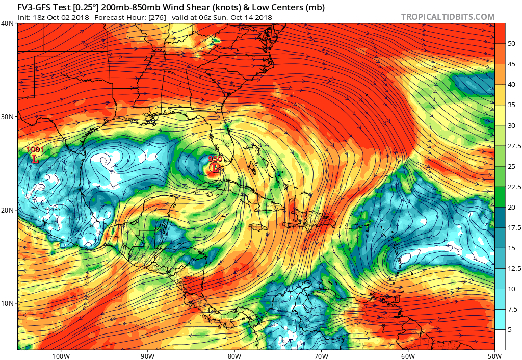
I’d say these are pretty good upper-level conditions on the approach to South Florida 
0 likes
-
TheStormExpert
Re: Broad area of disturbed weather in the southwestern Caribbean Sea
MetroMike wrote:TheStormExpert wrote:Ken711 wrote:GFS happy hour.
https://www.tropicaltidbits.com/analysis/models/gfs/2018100218/gfs_mslp_pcpn_atl_48.png
Not how I want to spend my birthday!! Thanks GFS!
In the morning it's likely to show something completely different.
Oh I know.
0 likes
-
gatorcane
- S2K Supporter
- Posts: 23708
- Age: 48
- Joined: Sun Mar 13, 2005 3:54 pm
- Location: Boca Raton, FL
Re: Broad area of disturbed weather in the Western Caribbean Sea
Pretty darn good upper-level conditions on the old GFS on its approach to Florida:
0 likes

Re: Broad area of disturbed weather in the Western Caribbean Sea
Are we sure the FV3-GFS is the new and improved GFS?
But all seriously at least in its short to med range it is in very good agreement with the Euro of development near Jamaica by this weekend, both have been persistent on this solution during the past day or so.


But all seriously at least in its short to med range it is in very good agreement with the Euro of development near Jamaica by this weekend, both have been persistent on this solution during the past day or so.
0 likes
-
northjaxpro

- S2K Supporter
- Posts: 8900
- Joined: Mon Sep 27, 2010 11:21 am
- Location: Jacksonville, FL
Re: Broad area of disturbed weather in the Western Caribbean Sea
stormlover2013 wrote:Models can’t be reliable till 3-4 days out
It will also help once we get a true and definitive dominant coc implemented and initialized on the model runs as well.
1 likes
NEVER, EVER SAY NEVER in the tropics and weather in general, and most importantly, with life itself!!
________________________________________________________________________________________
Fay 2008 Beryl 2012 Debby 2012 Colin 2016 Hermine 2016 Julia 2016 Matthew 2016 Irma 2017 Dorian 2019
________________________________________________________________________________________
Fay 2008 Beryl 2012 Debby 2012 Colin 2016 Hermine 2016 Julia 2016 Matthew 2016 Irma 2017 Dorian 2019
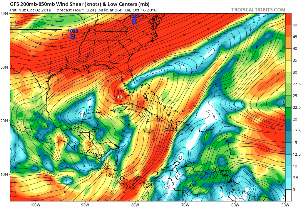
Re: Broad area of disturbed weather in the Western Caribbean Sea
Some of those runs are a long way out. Seemed to have moved out at least several more days now. Wake me when something has actually got going. It surely will change
0 likes

Re: Broad area of disturbed weather in the Western Caribbean Sea
That's well into Category 3, there.
0 likes
Re: Broad area of disturbed weather in the Western Caribbean Sea
The Eastern Vort seems to be dominating on 500 mB. In 200 mB, not a trace.
0 likes
-
Aric Dunn
- Category 5
- Posts: 21238
- Age: 43
- Joined: Sun Sep 19, 2004 9:58 pm
- Location: Ready for the Chase.
- Contact:
Re: Broad area of disturbed weather in the Western Caribbean Sea
like always dont really look past 48 to 72 hours. even less when there is no well defined llc... and then even more soo when there are these large gyre situations..
sooo essentially all the models are useful for right now is a general idea of something in the western carrib and a general improvement in possible shear. and a general motion through 72 hours .. beyond that its just fun to watch.
sooo essentially all the models are useful for right now is a general idea of something in the western carrib and a general improvement in possible shear. and a general motion through 72 hours .. beyond that its just fun to watch.
3 likes
Note: If I make a post that is brief. Please refer back to previous posts for the analysis or reasoning. I do not re-write/qoute what my initial post said each time.
If there is nothing before... then just ask
Space & Atmospheric Physicist, Embry-Riddle Aeronautical University,
I believe the sky is falling...
If there is nothing before... then just ask
Space & Atmospheric Physicist, Embry-Riddle Aeronautical University,
I believe the sky is falling...
-
AJC3

- Admin

- Posts: 4153
- Age: 62
- Joined: Tue Aug 31, 2004 7:04 pm
- Location: Ballston Spa, New York
- Contact:
Re: Broad area of disturbed weather in the Western Caribbean Sea
Abdullah wrote:The Eastern Vort seems to be dominating on 500 mB. In 200 mB, not a trace.
You wouldn't want to look anywhere close to that high in the atmosphere when it comes to a tracking development or consolidation of a LLC. Use 850MB...
http://tropic.ssec.wisc.edu/real-time/w ... oom=&time=
1 likes
-
northjaxpro
- S2K Supporter
- Posts: 8900
- Joined: Mon Sep 27, 2010 11:21 am
- Location: Jacksonville, FL
Re: Broad area of disturbed weather in the Western Caribbean Sea
Abdullah wrote:The Eastern Vort seems to be dominating on 500 mB. In 200 mB, not a trace.
This evening convection is already trying to fire back up again with that mid level spin in the West-Central Caribbean, despite shear.
Last edited by northjaxpro on Tue Oct 02, 2018 8:21 pm, edited 4 times in total.
0 likes
NEVER, EVER SAY NEVER in the tropics and weather in general, and most importantly, with life itself!!
________________________________________________________________________________________
Fay 2008 Beryl 2012 Debby 2012 Colin 2016 Hermine 2016 Julia 2016 Matthew 2016 Irma 2017 Dorian 2019
________________________________________________________________________________________
Fay 2008 Beryl 2012 Debby 2012 Colin 2016 Hermine 2016 Julia 2016 Matthew 2016 Irma 2017 Dorian 2019
Re: Broad area of disturbed weather in the Western Caribbean Sea
With questions about where any low leading to TC genesis would be located and when it would occur, climo going back to 1851 would be as good a wild guess as any at this very early stage....I.e., a move N to NE over FL. But obviously anything is on the table from a miss off the SE coast to a left hook into the SE US to a track into the Gulf, etc.and of course strength is way, way up in the air due to land interaction, El Niño enhanced shear in places, record warm SSTs for early October all around SE US, and extra unpredictability of strength in Oct.
1 likes
Personal Forecast Disclaimer:
The posts in this forum are NOT official forecasts and should not be used as such. They are just the opinion of the poster and may or may not be backed by sound meteorological data. They are NOT endorsed by any professional institution or storm2k.org. For official information, please refer to the NHC and NWS products.
The posts in this forum are NOT official forecasts and should not be used as such. They are just the opinion of the poster and may or may not be backed by sound meteorological data. They are NOT endorsed by any professional institution or storm2k.org. For official information, please refer to the NHC and NWS products.
Who is online
Users browsing this forum: No registered users and 154 guests