2021 Indicators: SST's / SAL / MSLP / Shear / Steering / Instability / Sat Images

This is the general tropical discussion area. Anyone can take their shot at predicting a storms path.

Moderator: S2k Moderators

Forum rules

The posts in this forum are NOT official forecasts and should not be used as such. They are just the opinion of the poster and may or may not be backed by sound meteorological data. They are NOT endorsed by any professional institution or STORM2K. For official information, please refer to products from the National Hurricane Center and National Weather Service.

Help Support Storm2K
Message
Author
User avatar
Teban54
Category 5
Category 5
Posts: 1983
Joined: Sat May 19, 2018 1:19 pm

Re: 2021 Indicators: SST's / SAL / MSLP / Shear / Steering / Instability / Sat Images

#3681 Postby Teban54 » Wed Sep 29, 2021 10:50 pm

CyclonicFury wrote:October 2020 actually had its strongest -VP200 anomalies over the NIO and the Maritime Continent, not the Atlantic and Africa.
https://i.imgur.com/1ix4XA0.png

CFS seems to focus the strongest -VP200 anomalies around the same area as 2020, yet shows much stronger shear and a much less favorable environment than last year.
https://i.imgur.com/bG0lfNr.png

That was actually something I wanted to post a while ago - October 2020 didn't have the most favorable VP anomalies. I remember posts saying a CCKW moved into the Caribbean around late October and stayed there throughout November, so November 2020 was the one that got the VP boost, but October actually had suppressive VP anomalies.

Maybe that explains the mid-level shear in October that crippled an RIing Delta and kept Zeta at Cat 1 before Yucatan. If that's the case, Gamma and Delta were simply lucky enough to find a small area of favorable conditions to bomb out.

Not sure this is 100% correct (in fact not even close to being sure).
1 likes   

MarioProtVI
Category 2
Category 2
Posts: 675
Age: 23
Joined: Sun Sep 29, 2019 7:33 pm
Location: New Jersey

Re: 2021 Indicators: SST's / SAL / MSLP / Shear / Steering / Instability / Sat Images

#3682 Postby MarioProtVI » Wed Sep 29, 2021 11:19 pm

Category5Kaiju wrote:
CyclonicFury wrote:October 2020 actually had its strongest -VP200 anomalies over the NIO and the Maritime Continent, not the Atlantic and Africa.
https://i.imgur.com/1ix4XA0.png

CFS seems to focus the strongest -VP200 anomalies around the same area as 2020, yet shows much stronger shear and a much less favorable environment than last year.
https://i.imgur.com/bG0lfNr.png


Hmm, well maybe the bigger question to ask is why exactly does the CFS think that the conditions this October won't be as favorable given what it is showing VP wise?

The CFS has been garbage with shear forecasts lately - it completely overdid the shear within the MDR for September and busted pretty badly, so I’m skeptical of CFS’s shear prediction verifying given it’s done pretty much poorly the last year with shear forecasts. All signs at this point in time signal another active late season, but not on the levels we saw last year. Still expect at least 2-3 hurricanes or so, with another major likely as well. Would put us around something like 24-11-5 with ~160 ACE (bulk of it due to Sam and Larry) by season’s end IMO.
1 likes   

User avatar
Teban54
Category 5
Category 5
Posts: 1983
Joined: Sat May 19, 2018 1:19 pm

Re: 2021 Indicators: SST's / SAL / MSLP / Shear / Steering / Instability / Sat Images

#3683 Postby Teban54 » Thu Sep 30, 2021 1:21 am

It's the last day of September. The month is now at 9-3-2, and 2021 now has the second fastest pace of all seasons in terms of NS count, only behind 2020. September produced two long-tracking MDR majors each with 30+ ACE. One of them was almost a Cat 5, with many people believing it might be recognized as one in TCR and/or is making another run at that intensity. Additionally, a tropical storm is currently forecast to become a rare October MDR hurricane, and it's currently organizing like a WPac typhoon. The month's ACE at the time of writing is approximately 69.9.

Now let's look at some of the bearish comments in this thread since early September and how they verified. I have removed all user names as my intention is not to bring anyone to shame - you might recognize your own comments, but believe me, I am not trying to offend you. The goal here is to demonstrate how quickly things can change in the tropics, and how hard it is to predict seasonal activity even just one or two weeks in advance.

TL;DR: When in doubt of a season's activity, KEEP CALM AND WATCH THE TROPICS.

------------------------------------------------------------------------------------------------

A few September cancel posts started popping up around September 5, when Larry was on its way out and models didn't show any additional development. At that time, most of the posts remained rational and was mostly suggesting September would not end up hyperactive, and not literally saying September would be dead. Most people also realized that activity was paused due to unfavorable CCKW, and should resume in late September and October.
(Sep 6) wrote:There’s definitely a long range inhibiting factor across the Atlantic not much to speak off in terms of development even at climo peak season.

(Sep 6) wrote:We are in peak season with a major hurricane in the Atlantic and models showing very little. What they did show they backed off on. Face it, every prognostication up to this point has been wrong. No strong hurricanes, no large hurricanes, season will be super busy! 5 to 8 storms in a 15 day period would be quite insane, and if you step back a second you will have to admit nearly impossible. Not every season is going to be mega hyper active, regardless of the indicators. There are multiple pieces of the puzzle we do not understand. What makes a season more or less active than we think it will be is what makes hurricanes seasons interesting, IMO. It will do what it will do, regardless.

:uarrow: The 13-day period from Sep 17 to Sep 29 produced 7 named storms. Even if we ignore Odette and Teresa (who were short-lived, likely subtropical, and questionable to some in the case of Odette), that would still be 5 named storms and enough quality from Sam.
(Sep 7) wrote:Stick a fork in the rest of September if SAL is actually a player

:uarrow: We did get a SAL outbreak like the models predicted, but Sam basically shrugged it off and reached Cat 4 while riding the southern boundary of a SAL plume. Even though it later on had occasional dry air intrusions, it still remained a major for several days.
(Sep 8) wrote:So can we admit that the MDR is underperforming relative to expectations for a second consecutive year?

(Sep 9) wrote:I'm expecting another big burst in activity, but I think at this point hyperactive is off the table, as it should be. One would hope hyperactive seasons are quite rare. This talk of hyperactivity has also diminished, in my opinion, how destructive non hyperactive seasons can be.

:uarrow: Current 5-day forecasts for Sam and Victor would bring us to 145+ ACE, just less than 15 units from the hyperactive threshold of 159.6.

------------------------------------------------------------------------------------------------

After September 10 is when the month cancel posts really began. Multiple active users were doubting even the possibility of anything substantial forming, which at one time made up half the posts (though there are also some obviously bullish users who insisted on more activity). This also coincided with the time when Euro backed off from its incredibly bullish pre-Peter forecasts, and the pre-Peter invest itself developed much later than expected with its development chances being reduced.

Many other posts that are not quoted here did not directly suggest that nothing would form, but instead "prepare for an active October".

(Sep 13) wrote:I would personally use September 20, rather than today's date, as a metric--storms like Lee, Maria, or Teddy had either already formed or were on the verge of formation, and had high model support for becoming strong hurricanes--the present model trend is towards there being no hurricanes (let alone majors) during the forecast period.

We're highly unlikely to have any majors (or any hurricanes at all) in the next week given the open Atlantic as everything (Larry included) has underperformed over the open Atlantic.

:uarrow: Sam formed near the end of the 10-day forecast period, on Sep 22.
(Sep 14) wrote:If the tropics continue to underwhelm worldwide after Chanthu/Larry/Nicholas, could this be foreshadowing a circulation collapse next year like in 2013? I recall people saying that 2012’s struggle storms (lots of formation but lots not reaching their full potential) was a sign of what was to come next season.

:uarrow: Besides the Atlantic, don't forget WPac produced another Cat 5 Mindulle, that is also shaping up to be a long-lived major just like Sam.
(Sep 14) wrote:2021 almost certainly will not get anywhere close to 2005 or 2020 levels of activity. Just because a favorable phase is coming up does not guarantee record levels of activity.

:uarrow: 
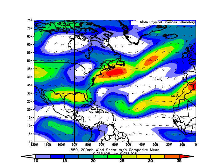
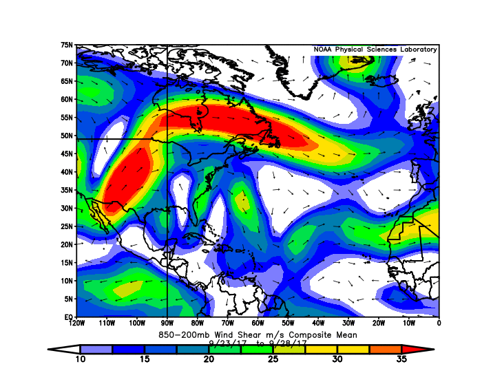
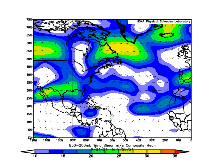
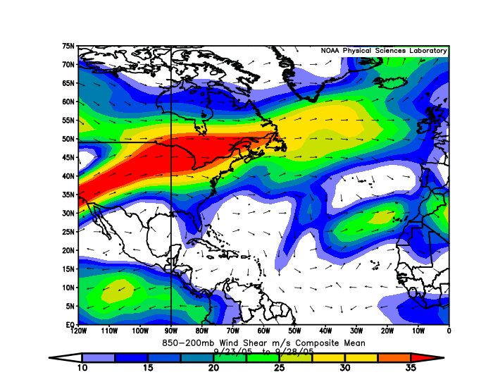
With 9 named storm formations, September 2021 is now the month with second highest named storms total. In terms of ACE, it is also doing better than September 2005 and 2020.
(Sep 14) wrote:This year seems like it's behaving more like 1985 or 2007, where the overwhelming majority of the open Atlantic either struggles or is void of storms (this year having Larry as an obvious exception), while everything near land peaks around landfall--look at Dean and Felix for example in 07 compared to the rest of the basin.

(Sep 16) wrote:If none of the three AOIs currently develop, the unfavorable MJO phase will likely halt development for weeks, and September will have had just 3 NS — lower than every other season of the current active stretch. Sept 2021 would be the weakest since 2016 despite Larry; 2017 had multiple long-trackers while 2018, 2019, and 2020 had other significant storms like Helene, Leslie, Humberto, Jerry, Lorenzo, Paulette, and Sally before or after their highest ACE long-tracker. Mindy was brief and Nicholas, while a hurricane landfall, is a far cry from the other storms I mentioned in both intensity and duration.

If no additional storms form, this would raise several questions: what killed September’s momentum despite climo peak coinciding with a developing Nina and an under-performing Pacific? Could we see a double-peak season like 2016 where both peaks are well before/after the normal peak in mid-September? And does this signal what the 2022 season could be like?

(Sep 16) wrote:It was noted by someone, a tweet maybe, that the jet stream was anomalously far north. I wonder if this actually sets up poorer conditions than expected, even though nina is present. The exciting thing is that we only learn when the unexpected happens, so like a 2013, now we might know what else to look for. Or not. :D

(Sep 16) wrote:I think you are clinging too hard to the idea that September was going to be hyperactive. Realistically a 10 named storm September was never likely even if the VP anomaly pattern was ideal. It's not unusual for September to be less active than August in years where August is very active. We've seen 3 storms this month including Larry (3-2-1), but it's possible we don't see another hurricane this month and ACE for the remainder of the month may be lackluster. I wouldn't be surprised if October was more active than normal, though.

(Sep 16) wrote:Nothing I'm seeing right now points to a hyperactive September. -CCKW and an unfavorable MJO phase are about to hit and last for the next few weeks. That doesn't mean nothing will form obviously, but I think a hyperactive 7+ named storm September is highly unlikely at this point. Late August and early September was the active phase this year, now late September is is the less favorable phase, which means October will likely be a favorable phase again. My guess is that the rest of September will not have a whole lot, followed by a dangerous burst of activity sometime in October.

(Sep 16) wrote:Everything out in the open Atlantic post-Larry has been hitting a wall or just falling apart entirely. Even Larry itself struggled in a marginal atmosphere and a marginal thermodynamic environment. Since the month only has 2 weeks left, a bunch of hurricanes forming and going bonkers across the basin (so as to meet the definition of a hyperactive September) when the intraseasonal state is pretty bad would be rather surprising at this point.

2021 does seem to be a year with a strong intraseasonal influence and it's reasonable to speculate that October could be more active based on the enhanced MJO predicted to arrive during the month. But IMO a hyperactive September is off the table. Probably a couple more systems and even a hurricane or two which would make the month average/slightly above-average at most but not hyperactive.

(Sep 16) wrote:September is already over half over. So far it has probably been about average, if not slightly above if you include Larry. Overall so far this September has been a lot less active than 2017-2020, as we have not even had a time with simultaneously active hurricanes so far this year. The MDR has not seen any TC develop since Larry. 95L and 96L still may develop but neither appear likely to be strong at this moment. The models aren't showing much of a signal for anything behind the 0/20 wave for the next 10 days. We could see activity perk up again at the very end of September, but it's not unreasonable to say activity will be below average for the next 7-10 days. The EPS seems to have a bias to show -VP200 over Africa and the IO all the time, it seems as if the suppressed phase will be a negative factor for development for the next week or two.

Thus far, your prediction of a hyperactive September has not verified.

:uarrow: 10 days from that is Sep 26, when Sam officially peaked at 135 kts.

------------------------------------------------------------------------------------------------

Peter and Rose both formed on September 19. They shut down the month cancel posts for a short while, but the focus quickly shifted to lack of quality, especially when Peter and Rose were battling strong shear and became naked swirls.
(Sep 18) wrote:I respectfully disagree. One would have expected higher ACE during peak season, given -ENSO/-PDO/+IOD/-VE.

(Sep 18) wrote:I think everyone here was expecting a September with plenty of land threats and, you know, normal September activity. But it’s been pathetic with the exception of Larry, which was limited by some factor we don’t truly understand yet. The other two invests now don’t seem like they’ll contribute much to the ACE total either, and then after that the basin will probably shut down for a few weeks (I don’t buy the model forecasts for more MDR systems).

2021 could potentially end up with below-average ACE if the enhanced phase in October somehow doesn’t yield anything. If so, forecasts from some of the top organizations in the field will bust quite badly, and extensive research will be needed to figure out why.

:uarrow: 2021's ACE has already passed the average threshold. If the current 5-day forecasts for Sam and Victor play out, we would be well over the above-average ACE on Oct 5.
The season as a whole is currently at 20-7-4. With the exception of H count, it already meets or surpasses every agency's final forecast. CSU forecasted 150 ACE in August; Sam and Victor might bring us to just within 10 units below that.
(Sep 18) wrote:Can't help but wonder if we end up hurricane-free the rest of September at this rate. Models seem to just spin up storms and then fizzle the closer it gets.

(Sep 19) wrote:Given the massive amount of shear and widespread PV streamers that are out there, I can't help wonder if there's something similar to 2013 with the ocean circulation going on (and similarly if this happened to some degree later in the 2007 season as well) or if there's some unknown factor specific to this sort of La Nina.

:uarrow: Reminder: When making 2013 comparisons, focus on the underlying background conditions and not just the quantity and quality of storms. But even then, it's clear that 2021 has much better conditions than 2013.
(Sep 19) wrote:Are we sure conditions will become more favorable in that short of a time frame? I thought the suppressed MJO phase was supposed to peak at the end of September.

:uarrow: We technically haven't left the suppressed MJO phase yet. Sam and Victor, as well as other weaker storms, seem to be related to a CCKW passage. And yes, Sam bombed out when there's anomalously sinking air.
(Sep 19) wrote:Yeah we have a serious dearth of quality this September. Clinging to storm counts to try to compare this year to 2005 at this point is...like going trick or treating and getting a ton of candy corn. No one wants that stuff. In a season with high expectations folks are looking for quality in september and they haven't gotten it. Still, for those that like a lack of stress, upright trees and functioning power, this peak season relative tranquility has been a blessing. I'll be shocked if someone doesn't get a good scare (or worse) from a significant storm in October..but the free pass at the apex of climo mountain is as nice as it was unexpected.

(Sep 19) wrote:From a numbers perspective I could see 20+ named storms happening with a potential shot at the auxiliary list. From a quality perspective? I expect October to have stronger storms than September due to the MJO being in a more favorable position, but neither Peter nor 16L look likely to become strong at this time. Chances of 2021 reaching 150+ ACE are decreasing, without nothing short of a 2020-esque late season.

If 2021 finished like 21-8-4 I wouldn't say it rivaled 2005 and 2020.

(Sep 20) wrote:While both years featured strangely similar August activity, September is setting this year apart quite dramatically from those two--2020 had four hurricanes during September (this year looks like it'll have to try extra hard just to reach three) and five storms active at once. 2005 had already seen five hurricanes by this point, including two majors, and didn't really see any struggling storms. Both years also had at least one instance of three active hurricanes at once--this year is struggling just in maintaining two named storms at once, and has at no point had multiple hurricanes at any given time.

We're seeing a strange combination of overperforming storms in the Gulf, but the Gulf/Caribbean drastically underperforming in the total number of storms, while the open Atlantic underperforms in intensity with most systems struggling to exceed 50 mph.

:uarrow: Even though 2021 didn't have concurrent hurricanes (that might change soon with Victor), September 2021 has more ACE and more long-trackers than both September 2005 and 2020. Its major hurricane count is also tied with 2005 (which had Maria and Rita) and surpassed 2020 (just Teddy).
16 likes   

User avatar
weeniepatrol
Category 3
Category 3
Posts: 870
Joined: Sat Aug 22, 2020 5:30 pm
Location: WA State

Re: 2021 Indicators: SST's / SAL / MSLP / Shear / Steering / Instability / Sat Images

#3684 Postby weeniepatrol » Thu Sep 30, 2021 2:58 am

A thorough and definitive patrolling. :spam:

Major hurricane days are now 199% of normal (and rising). Contrast this with the western and eastern Pacific basins which are below climatology in virtually every category for the second year in a row.
6 likes   

User avatar
Hammy
Category 5
Category 5
Posts: 5594
Age: 40
Joined: Fri May 25, 2012 5:25 pm
Contact:

Re: 2021 Indicators: SST's / SAL / MSLP / Shear / Steering / Instability / Sat Images

#3685 Postby Hammy » Thu Sep 30, 2021 3:16 am

MarioProtVI wrote:
Category5Kaiju wrote:
CyclonicFury wrote:October 2020 actually had its strongest -VP200 anomalies over the NIO and the Maritime Continent, not the Atlantic and Africa.
https://i.imgur.com/1ix4XA0.png

CFS seems to focus the strongest -VP200 anomalies around the same area as 2020, yet shows much stronger shear and a much less favorable environment than last year.
https://i.imgur.com/bG0lfNr.png


Hmm, well maybe the bigger question to ask is why exactly does the CFS think that the conditions this October won't be as favorable given what it is showing VP wise?

The CFS has been garbage with shear forecasts lately - it completely overdid the shear within the MDR for September and busted pretty badly, so I’m skeptical of CFS’s shear prediction verifying given it’s done pretty much poorly the last year with shear forecasts. All signs at this point in time signal another active late season, but not on the levels we saw last year. Still expect at least 2-3 hurricanes or so, with another major likely as well. Would put us around something like 24-11-5 with ~160 ACE (bulk of it due to Sam and Larry) by season’s end IMO.


The weeklies (which are the only ones I use) were fairly accurate as Larry and Sam throw off the monthly average. Outside of those two, it was actually above normal over most of the Atlantic, particularly the subtropics where most storms were steered.

To the bold, the October 6-13 VP anomalies have a pocket of highest instability over the eastern Pacific, which could be behind the shear forecasts for the Caribbean, in addition to most models showing fronts getting much further south than in recent Octobers.
0 likes   
The above post is not official and should not be used as such. It is the opinion of the poster and may or may not be backed by sound meteorological data. It is not endorsed by any professional institution or storm2k.org. For official information, please refer to the NHC and NWS products.

User avatar
kevin
Category 5
Category 5
Posts: 1793
Age: 25
Joined: Wed Aug 28, 2019 4:35 am

Re: 2021 Indicators: SST's / SAL / MSLP / Shear / Steering / Instability / Sat Images

#3686 Postby kevin » Thu Sep 30, 2021 4:07 am

I like to look at TCs on a global perspective, so here are the most intense (by pressure) TCs for each month worldwide so far in 2021. I also added a list of the top 10 most intense ones of the entire list to date. If equal in pressure I used the wind speed as the deciding factor.

---

Month / Name / Basin / Pressure (mbar) / Wind speed (1-min, kt) / Category (SSHWS)

January / Eloise / SWIO / 967 / 90 / 2
February / Faraji / SWIO / 925 / 140 / 5
March / Habana / SWIO / 938 / 125 / 4
April / Surigae / WPAC / 895 / 165 / 5
May / Tauktae / NIO / 950 / 120 / 4
June / Enrique / EPAC / 975 / 80 / 1
July / Felicia / EPAC / 947 / 125 / 4
August / Ida / NATL / 929 / 130 / 4
September / Chantu / WPAC / 905 / 155 / 5

---

Top 10

# / Name / Basin / Pressure (mbar) / Wind speed (1-min, kt) / Category (SSHWS)

01 / Surigae / WPAC / 895 / 165 / 5
02 / Chantu / WPAC / 905 / 155 / 5
03 / Mindulle / WPAC / 920 / 145 / 5
04 / Faraji / SWIO / 925 / 140 / 5
05 / Sam / NATL / 929 / 135 / 4
06 / Ida / NATL / 929 / 130 / 4
07 / Niran / SPAC / 931 / 140 / 5
08 / Habana / SWIO / 938 / 125 / 4
09 / Felicia / EPAC / 947 / 125 / 4
10 / Tauktae / NIO / 950 / 120 / 4
0 likes   

tolakram
Admin
Admin
Posts: 19182
Age: 60
Joined: Sun Aug 27, 2006 8:23 pm
Location: Florence, KY (name is Mark)

Re: 2021 Indicators: SST's / SAL / MSLP / Shear / Steering / Instability / Sat Images

#3687 Postby tolakram » Thu Sep 30, 2021 7:39 am

Teban54 wrote:The goal here is to demonstrate how quickly things can change in the tropics, and how hard it is to predict seasonal activity even just one or two weeks in advance.

TL;DR: When in doubt of a season's activity, KEEP CALM AND WATCH THE TROPICS.


I question your goal with that wall of text, and I'm not a fan of taking quotes out of context. You also called some posts cancel posts when they were most certainly not.

I'll defend my post where I was trying to point out EVERYONE was wrong, both the bears and the bulls, at that point in time. It was made after Larry was already a major and a HUGE storm. I already addressed the storm counts with alphatoomega in a post that quoted it.

This is an indicators and analysis thread, not a storm thread. People need to feel free to post their analysis as long as it doesn't contain misinformation. Every post is made at a single point in time in a thread designed to evaluate indicators. Many of us have been around a long time and have seen seasons both overperform and underperform, which is one of the reasons we have this thread every year. There is a difference between posts trying to analyze conditions and those saying we will have another 2013, without context.

I'd also add, maybe tease, that those who dislike the ACE metric can't also claim this season is hyperactive because we had two long trackers adding a lot of ACE. :) You can point to the number of storms and claim a super active season, but then you have to own Peter, Odessa, and Teresa (Rose looked legit for a while, then poofed, but could also be added to the list). All formed during peak season (as we define it now). Two NHC forecasters referred to these as shorties, recognizing that while using names, they existed due to better detection, not better conditions.

There's still 2 months or more to go, who knows what will happen? I don't. I don't believe we will see any more significant coastal threats (Florida is the exception) due to a more typical fall like pattern, but there's always a pause after that first cold front before activity picks back up. The secondary October peak is real and conditions can and will change. Edit: I should add, that if we get a very strong storm in the center of the Gulf moving fairly rapidly toward the coast then the threat is still real.


SEASON CANCEL: A post that tries to convince everyone that the season is a bust, sometimes backed up with data but usually just filled with either quotes or data that does not back up the assertion.

There is an opposite to SEASON CANCEL but I'm not sure what to call it. In both cases the posters will come back and attempt to shame the other side when their "claims" come true. :spam:
4 likes   
M a r k
- - - - -
Join us in chat: Storm2K Chatroom Invite. Android and IOS apps also available.

The posts in this forum are NOT official forecasts and should not be used as such. Posts are NOT endorsed by any professional institution or STORM2K.org. For official information and forecasts, please refer to NHC and NWS products.

AlphaToOmega
Category 5
Category 5
Posts: 1448
Joined: Sat Jun 26, 2021 10:51 am
Location: Somewhere in Massachusetts

Re: 2021 Indicators: SST's / SAL / MSLP / Shear / Steering / Instability / Sat Images

#3688 Postby AlphaToOmega » Thu Sep 30, 2021 2:18 pm

I will say that the CFSv2 has overestimated wind shear in the deep tropics of the North Atlantic.

Forecasted wind shear:
Image

Actual wind shear:
Image

Actual wind shear in the MDR was <6 meters/second, which translates to <11 knots. The CFSv2 forecasted 10-20 knots of wind shear in the MDR. Actual wind shear in the Caribbean was 9-10 meters/second, which translates to 19-20 knots. The CFSv2 forecasted 20-30 knots of wind shear in the Caribbean.
4 likes   

User avatar
Hammy
Category 5
Category 5
Posts: 5594
Age: 40
Joined: Fri May 25, 2012 5:25 pm
Contact:

Re: 2021 Indicators: SST's / SAL / MSLP / Shear / Steering / Instability / Sat Images

#3689 Postby Hammy » Thu Sep 30, 2021 3:38 pm

:uarrow: The forecast shear amount does appear to have been higher (double, even), but it is still curious as to why that kind of shear is present in a La Nina year in the first place. The modeling did correctly show that the overall atmosphere is not behaving like a typical La Nina, and that it seems the waves are finding pockets that are favorable, allowing them to ramp up quickly, rather than having broader hurricane outbreaks more common seen with a La Nina.

As it looks increasingly unlikely Victor will become a hurricane (and in fact seems it's refusing to intensify at all as of this post), and conditions don't appear to favor a backloaded season like 2016 or 2020, this year's raw numbers are turning out like 2019--massive number of storms but average number of hurricanes, but a few of them broke through the conditions and became fairly intense, and then mostly everything else struggles--very uneven, with far less hurricanes than one would expect for the storm numbers, yet more majors than one would expect given the low percentage that reached hurricane intensity. Both years also saw all of the non-majors being very short-lived at hurricane intensity.

2021 has also been unusual in regard to two things commonly seen in most other active seasons--at no point have two hurricanes been active, and outside of a single advisory as Fred moved inland, there has not at any point been three storms of at least tropical storm intensity active at once, benchmarks I've been using as a comparative reference since 1995.

I'm not sure what the background cause of these sort of seasons is, as they don't seem common, if anybody might have any insight into that. Most other similar types of seasons tended to concentrate activity in the subtropics--1984 and 2002 being examples.

I'm sure this will be taken as a season cancel post, but it's a mere raw observation that something unknown is up with the overall atmosphere that is not typically present in an active season, where several storms that should have had more favorable conditions simply didn't.
4 likes   
The above post is not official and should not be used as such. It is the opinion of the poster and may or may not be backed by sound meteorological data. It is not endorsed by any professional institution or storm2k.org. For official information, please refer to the NHC and NWS products.

AlphaToOmega
Category 5
Category 5
Posts: 1448
Joined: Sat Jun 26, 2021 10:51 am
Location: Somewhere in Massachusetts

Re: 2021 Indicators: SST's / SAL / MSLP / Shear / Steering / Instability / Sat Images

#3690 Postby AlphaToOmega » Thu Sep 30, 2021 4:09 pm

Hammy wrote::uarrow: The shear amount does appear to have been higher, but that leads to the question as to why that kind of shear is present in a La Nina year in the first place. The modeling did correctly show that the overall atmosphere is not behaving like a typical La Nina, and that some waves are finding pockets that are favorable, allowing them to ramp up quickly, rather than having larger-scale TC outbreaks.

As it looks increasingly unlikely Victor will become a hurricane (and in fact seems it's refusing to intensify at all as of this post), and conditions don't appear to favor a backloaded season like 2016 or 2020, this year's raw numbers are turning out like 2019--massive number of storms but average number of hurricanes, but a few of them broke through the conditions and became fairly intense, and then mostly everything else struggles--very uneven, with far less hurricanes than one would expect for the storm numbers, yet more majors than one would expect given the low percentage that reached hurricane intensity. Both years also saw all of the non-majors being very short-lived at hurricane intensity.

2021 has also been unusual in regard to two things commonly seen in most other active seasons--at no point have two hurricanes been active, and outside of a single advisory as Fred moved inland, there has not at any point been three storms of at least tropical storm intensity active at once, benchmarks I've been using as a comparative reference since 1995.

I'm not sure what the background cause of these sort of seasons is, as they don't seem common, if anybody might have any insight into that. Most other similar types of seasons tended to concentrate activity in the subtropics--1984 and 2002 being examples.

I'm sure this will be taken as a season cancel post, but it's a mere raw observation that something unknown is up with the overall atmosphere that is not typically present in an active season, where several storms that should have had more favorable conditions simply didn't.


A few weeks before October 2020, there were Tropical Storms Vicky and Wilfred, which were "junk" storms in the MDR. A few weeks is all that is needed to change the course of a season.

In terms of subtropics, they seem to have been quite dead this season for whatever reason.

I also am just not seeing a 1984-esque or 2002-esque October.

Image
Image
Image
Image

Instead, I am seeing something similar to 2005/2020.

Image
2 likes   

User avatar
Hammy
Category 5
Category 5
Posts: 5594
Age: 40
Joined: Fri May 25, 2012 5:25 pm
Contact:

Re: 2021 Indicators: SST's / SAL / MSLP / Shear / Steering / Instability / Sat Images

#3691 Postby Hammy » Thu Sep 30, 2021 4:16 pm

:uarrow: No comparison with 1984/2002 (though 1984 did have three hurricanes after September) but more that having a seemingly disproportionately high number of storms vs hurricane numbers (20 and 7) is something I haven't seen often outside of those types of setups, where 1984 had 13/5 and 2002 12/4. That we're seeing this in a year with a productive MDR, during a La Nina, is quite odd and something I'm curious to know the mechanics behind.
0 likes   
The above post is not official and should not be used as such. It is the opinion of the poster and may or may not be backed by sound meteorological data. It is not endorsed by any professional institution or storm2k.org. For official information, please refer to the NHC and NWS products.

User avatar
CyclonicFury
Category 5
Category 5
Posts: 1977
Age: 25
Joined: Sun Jul 02, 2017 12:32 pm
Location: NC
Contact:

Re: 2021 Indicators: SST's / SAL / MSLP / Shear / Steering / Instability / Sat Images

#3692 Postby CyclonicFury » Thu Sep 30, 2021 4:22 pm

Even with all the bearish talk, I'd still be shocked if we didn't see at least one more hurricane in the Caribbean or Gulf of Mexico. It's a -ENSO year with a warmer than normal Caribbean. The first week of October looks suppressed, but by mid-October the environment looks more conducive.

Has 2021 really not behaved like a typical Niña year? The EPAC has been quiet while the Atlantic has been quite active over the past several weeks. The Caribbean Sea has already produced 3 hurricanes earlier in the season (albeit all Category 1s). I don't put a lot of stock into the CFS forecast for October, but there are years where October unexpectedly underperforms in the Caribbean, like 2007.
7 likes   
NCSU B.S. in Meteorology Class of 2021. Tropical weather blogger at http://www.cyclonicfury.com. My forecasts and thoughts are NOT official, for official forecasts please consult the National Hurricane Center.

User avatar
Category5Kaiju
Category 5
Category 5
Posts: 3438
Age: 22
Joined: Thu Dec 24, 2020 12:45 pm
Location: Seattle

Re: 2021 Indicators: SST's / SAL / MSLP / Shear / Steering / Instability / Sat Images

#3693 Postby Category5Kaiju » Thu Sep 30, 2021 4:27 pm

CyclonicFury wrote:Even with all the bearish talk, I'd still be shocked if we didn't see at least one more hurricane in the Caribbean or Gulf of Mexico. It's a -ENSO year with a warmer than normal Caribbean. The first week of October looks suppressed, but by mid-October the environment looks more conducive.

Has 2021 really not behaved like a typical Niña year? The EPAC has been quiet while the Atlantic has been quite active over the past several weeks. The Caribbean Sea has already produced 3 hurricanes earlier in the season (albeit all Category 1s). I don't put a lot of stock into the CFS forecast for October, but there are years where October unexpectedly underperforms in the Caribbean, like 2007.


2007 was a very weird year, it had mainly to do with very meager sst anomalies basin wide from what I can tell. In fact, that season as a whole struggled with ACE (ended only in the double digits), and if anything 2007 had more of a -AMO appearance than a +AMO; whatever happens this year, I think it's pretty clear that with the very warm sst anomalies and +AMO look as well as a solidly developing La Nina that October and November will feature decent activity. Plus, being at nearly 120 ACE already by October 1 makes me think this season is well-primed to do something later.
3 likes   
Unless explicitly stated, all information covered in my posts is based on my opinions and observations. Please refer to a professional meteorologist or an accredited weather research agency otherwise, especially if serious decisions must be made in the event of a potentially life-threatening tropical storm or hurricane.

AlphaToOmega
Category 5
Category 5
Posts: 1448
Joined: Sat Jun 26, 2021 10:51 am
Location: Somewhere in Massachusetts

Re: 2021 Indicators: SST's / SAL / MSLP / Shear / Steering / Instability / Sat Images

#3694 Postby AlphaToOmega » Thu Sep 30, 2021 4:43 pm

:uarrow: :uarrow:
I took the wind shear maps from September 23 to September 28 for every cool-neutral, weak La Nina, or moderate La Nina year with +AMO. What I am seeing is that it is not uncommon for La Nina seasons to have less-than-ideal wind shear in the Caribbean and/or the Gulf of Mexico in late September. For instance, 2001 featured ridiculously high wind shear in the Gulf of Mexico and the Caribbean Sea during late September; about a week later, Category IV Major Hurricane Iris formed. 2020 also featured somewhat high wind shear across the Gulf Coast during late September, and Hurricanes Delta and Zeta made landfall in that region; in fact, Hurricane Zeta intensified right before landfall.

As to what is causing this pattern in the first place, I cannot explain that. It is probably related to CCKWs and/or MJO, but do not quote me on that.

Image
Image
Image
Image
Image
Image
Image
Image
Image
5 likes   

User avatar
Hammy
Category 5
Category 5
Posts: 5594
Age: 40
Joined: Fri May 25, 2012 5:25 pm
Contact:

Re: 2021 Indicators: SST's / SAL / MSLP / Shear / Steering / Instability / Sat Images

#3695 Postby Hammy » Thu Sep 30, 2021 4:49 pm

CyclonicFury wrote:Even with all the bearish talk, I'd still be shocked if we didn't see at least one more hurricane in the Caribbean or Gulf of Mexico. It's a -ENSO year with a warmer than normal Caribbean. The first week of October looks suppressed, but by mid-October the environment looks more conducive.

Has 2021 really not behaved like a typical Niña year? The EPAC has been quiet while the Atlantic has been quite active over the past several weeks. The Caribbean Sea has already produced 3 hurricanes earlier in the season (albeit all Category 1s). I don't put a lot of stock into the CFS forecast for October, but there are years where October unexpectedly underperforms in the Caribbean, like 2007.


Activity in the Atlantic has been relatively spotty compared to the more continuous activity that was seen in years like 1995, 1998-2000, 2005, 08, 10-11, 17, or 20. The TUTT has been very pronounced this year for reasons unknown, to an extent I don't recall seeing in a La Nina since 2007.

Fred, Kate, Mindy, and Peter for instance seem like they should've faced much better conditions than they did given the overall indicators.
0 likes   
The above post is not official and should not be used as such. It is the opinion of the poster and may or may not be backed by sound meteorological data. It is not endorsed by any professional institution or storm2k.org. For official information, please refer to the NHC and NWS products.

User avatar
Category5Kaiju
Category 5
Category 5
Posts: 3438
Age: 22
Joined: Thu Dec 24, 2020 12:45 pm
Location: Seattle

Re: 2021 Indicators: SST's / SAL / MSLP / Shear / Steering / Instability / Sat Images

#3696 Postby Category5Kaiju » Thu Sep 30, 2021 5:43 pm

Hammy wrote:
CyclonicFury wrote:Even with all the bearish talk, I'd still be shocked if we didn't see at least one more hurricane in the Caribbean or Gulf of Mexico. It's a -ENSO year with a warmer than normal Caribbean. The first week of October looks suppressed, but by mid-October the environment looks more conducive.

Has 2021 really not behaved like a typical Niña year? The EPAC has been quiet while the Atlantic has been quite active over the past several weeks. The Caribbean Sea has already produced 3 hurricanes earlier in the season (albeit all Category 1s). I don't put a lot of stock into the CFS forecast for October, but there are years where October unexpectedly underperforms in the Caribbean, like 2007.


Activity in the Atlantic has been relatively spotty compared to the more continuous activity that was seen in years like 1995, 1998-2000, 2005, 08, 10-11, 17, or 20. The TUTT has been very pronounced this year for reasons unknown, to an extent I don't recall seeing in a La Nina since 2007.

Fred, Kate, Mindy, and Peter for instance seem like they should've faced much better conditions than they did given the overall indicators.


Just curious, but could you explain what you mean by "spotty?" Like are you referring to how this season saw bursts and lulls repeatedly? Also didn't the La Nina year 2016 have very unfavorable conditions and TUTTs in September, leading to a very inactive majority of the month? Part of me thinks that TUTTs are typhoon-enhanced, and this year we did see Chanthu and Mindulle.
2 likes   
Unless explicitly stated, all information covered in my posts is based on my opinions and observations. Please refer to a professional meteorologist or an accredited weather research agency otherwise, especially if serious decisions must be made in the event of a potentially life-threatening tropical storm or hurricane.

User avatar
aspen
Category 5
Category 5
Posts: 8061
Joined: Sat Oct 12, 2019 7:10 pm
Location: Connecticut, USA

Re: 2021 Indicators: SST's / SAL / MSLP / Shear / Steering / Instability / Sat Images

#3697 Postby aspen » Thu Sep 30, 2021 5:43 pm

The suppressive Kelvin Wave might actually increase the risk for something big in the Caribbean, because it’ll give the basin time to recharge and allow waves to sneak further west without developing and recurving. Once the enhanced phase arrives, there will likely be at least one wave in an optimal position to possibly develop.
4 likes   
Irene '11 Sandy '12 Hermine '16 5/15/2018 Derecho Fay '20 Isaias '20 Elsa '21 Henri '21 Ida '21

I am only a meteorology enthusiast who knows a decent amount about tropical cyclones. Look to the professional mets, the NHC, or your local weather office for the best information.

User avatar
Hammy
Category 5
Category 5
Posts: 5594
Age: 40
Joined: Fri May 25, 2012 5:25 pm
Contact:

Re: 2021 Indicators: SST's / SAL / MSLP / Shear / Steering / Instability / Sat Images

#3698 Postby Hammy » Thu Sep 30, 2021 7:02 pm

Category5Kaiju wrote:
Hammy wrote:
CyclonicFury wrote:Even with all the bearish talk, I'd still be shocked if we didn't see at least one more hurricane in the Caribbean or Gulf of Mexico. It's a -ENSO year with a warmer than normal Caribbean. The first week of October looks suppressed, but by mid-October the environment looks more conducive.

Has 2021 really not behaved like a typical Niña year? The EPAC has been quiet while the Atlantic has been quite active over the past several weeks. The Caribbean Sea has already produced 3 hurricanes earlier in the season (albeit all Category 1s). I don't put a lot of stock into the CFS forecast for October, but there are years where October unexpectedly underperforms in the Caribbean, like 2007.


Activity in the Atlantic has been relatively spotty compared to the more continuous activity that was seen in years like 1995, 1998-2000, 2005, 08, 10-11, 17, or 20. The TUTT has been very pronounced this year for reasons unknown, to an extent I don't recall seeing in a La Nina since 2007.

Fred, Kate, Mindy, and Peter for instance seem like they should've faced much better conditions than they did given the overall indicators.


Just curious, but could you explain what you mean by "spotty?" Like are you referring to how this season saw bursts and lulls repeatedly? Also didn't the La Nina year 2016 have very unfavorable conditions and TUTTs in September, leading to a very inactive majority of the month? Part of me thinks that TUTTs are typhoon-enhanced, and this year we did see Chanthu and Mindulle.


That's interesting, and would make sense.

By spotty I mean we've pretty much had a 2014-esque scenario, albeit with stronger (and more) systems--quiet period, burst of activity that produces one hurricane and a few weaker systems, followed by more quiet. In 2014, each burst produced one storm, which became a hurricane--early July, each end of August, mid-September, and then the season peak in October. This year we've had more activity with each burst, but we've still failed to have more than one hurricane at a time.

Most La Nina years have had multiple longer-lasting storms and bursts of 3-4 storms at once across the basin, a recent non-2020 example would be early September when we had Florence, Isaac, and Helene all active at once, and I believe all three were hurricanes at the same time for about a day. We also had multiple longer-lasting systems at once, and several that overlapped--a setup that has been notably absent this year--where it's been one long-tracker with a few shorties, quiet, and then repeat.

A good example, 1996 and 2021 are fairly similar as far as September goes--both years flanked by a major hurricane at each end, with not a whole lot of activity between (this year differed in having a hurricane in the Gulf, and some weaker tropical storms.) Now, compare how August went--we did have two major hurricanes, both landfalling, but the favorable conditions were more local to the Gulf (obviously extremely unfortunate for land impacts) where 1996 had Edouard and Fran--both long trackers--preceding Hortense, in addition to Dolly in the Gulf and weaker Gustav between Edouard and Fran. 1999 was another September largely dominated by two systems--Floyd and Gert--that had a stronger burst in August: Cat 4 Bret in the Gulf, and Cindy and Dennis in the Atlantic, accompanied by Emily. Those are more characteristic interconnected bursts of activity that I'm referring to that seem more 'typical' for La Nina seasons.

2016 on the other hand was actually trending below normal as, excluding Alex in January, we'd only managed three hurricanes in and around actual hurricane season by late September.
0 likes   
The above post is not official and should not be used as such. It is the opinion of the poster and may or may not be backed by sound meteorological data. It is not endorsed by any professional institution or storm2k.org. For official information, please refer to the NHC and NWS products.

Nuno
Category 2
Category 2
Posts: 532
Joined: Fri Aug 30, 2019 8:35 am
Location: Coral Gables, FL

Re: 2021 Indicators: SST's / SAL / MSLP / Shear / Steering / Instability / Sat Images

#3699 Postby Nuno » Thu Sep 30, 2021 7:14 pm

aspen wrote:The suppressive Kelvin Wave might actually increase the risk for something big in the Caribbean, because it’ll give the basin time to recharge and allow waves to sneak further west without developing and recurving. Once the enhanced phase arrives, there will likely be at least one wave in an optimal position to possibly develop.


GFS was hinting at something like this in the ten day time frame.
0 likes   
Andrew (1992), Irene (1999), Frances (2004), Katrina (2005), Wilma (2005), Fay (2008), Irma (2017), Eta (2020), Ian (2022)

User avatar
Teban54
Category 5
Category 5
Posts: 1983
Joined: Sat May 19, 2018 1:19 pm

Re: 2021 Indicators: SST's / SAL / MSLP / Shear / Steering / Instability / Sat Images

#3700 Postby Teban54 » Thu Sep 30, 2021 8:46 pm

tolakram wrote:
Teban54 wrote:The goal here is to demonstrate how quickly things can change in the tropics, and how hard it is to predict seasonal activity even just one or two weeks in advance.

TL;DR: When in doubt of a season's activity, KEEP CALM AND WATCH THE TROPICS.


I question your goal with that wall of text, and I'm not a fan of taking quotes out of context. You also called some posts cancel posts when they were most certainly not.

I'll defend my post where I was trying to point out EVERYONE was wrong, both the bears and the bulls, at that point in time. It was made after Larry was already a major and a HUGE storm. I already addressed the storm counts with alphatoomega in a post that quoted it.

This is an indicators and analysis thread, not a storm thread. People need to feel free to post their analysis as long as it doesn't contain misinformation. Every post is made at a single point in time in a thread designed to evaluate indicators. Many of us have been around a long time and have seen seasons both overperform and underperform, which is one of the reasons we have this thread every year. There is a difference between posts trying to analyze conditions and those saying we will have another 2013, without context.

I'd also add, maybe tease, that those who dislike the ACE metric can't also claim this season is hyperactive because we had two long trackers adding a lot of ACE. :) You can point to the number of storms and claim a super active season, but then you have to own Peter, Odessa, and Teresa (Rose looked legit for a while, then poofed, but could also be added to the list). All formed during peak season (as we define it now). Two NHC forecasters referred to these as shorties, recognizing that while using names, they existed due to better detection, not better conditions.

There's still 2 months or more to go, who knows what will happen? I don't. I don't believe we will see any more significant coastal threats (Florida is the exception) due to a more typical fall like pattern, but there's always a pause after that first cold front before activity picks back up. The secondary October peak is real and conditions can and will change. Edit: I should add, that if we get a very strong storm in the center of the Gulf moving fairly rapidly toward the coast then the threat is still real.


SEASON CANCEL: A post that tries to convince everyone that the season is a bust, sometimes backed up with data but usually just filled with either quotes or data that does not back up the assertion.

There is an opposite to SEASON CANCEL but I'm not sure what to call it. In both cases the posters will come back and attempt to shame the other side when their "claims" come true. :spam:

Thanks for the great reply - I'm serious.

My post was not a "you lose I win" post, or at least I didn't intend it to be. It started off as me just casually browsing through the posts, and what drove me to actually write the post was the observation that, as September went on, the discussions became a lot more desperate and with lower depth of analysis. There were many GREAT, thoughtful discussions of indicators throughout the season, whether it's for activity in general or possibility of CONUS landfall; however, they were way more concentrated towards the first half of September.

By Sep 16 or so, you can clearly see a shift in tone and sentiment from "MJO is coming, but TUTTs, SAL and other factors may limit development" to "nah everything underperformed, the whole month will be dud". I already tried to leave out posts about how the month has been performing and quoted those about how it will perform (though the filter is not always accurate), but you can still see the sheer number of replies about the latter. At times, some of these comments feel more like complaints than analysis about indicators, especially when made without anything to back them up (I appreciate those giving concrete reasoning about why the inactive trend may continue). A smaller but sizable number of comments were about how getting 7+ TS or hyperactive ACE were unlikely - which were completely valid points at that time - but I do think they show people were more pessimistic about the season than what actually happened, and the pessimism only grew stronger with time (understandable given the lackluster mid September).

For this reason, the first few comments, in particular the one you were referring to, were terrible examples in showing what I wanted to say; I admit I should have made that clearer form the start. I actually fully agree with that comment of yours, and I appreciate your effort to maintain a balance in these discussions all the time.

Which brings me to my next point: there are definitely as many "season hype" posts as "season cancel" posts in general, and posts on both sides are made with or without supporting evidence. I cringe at the overly aggressive posts just as much as I do to the blind 2013 comparisons, and if this September actually ended up below average, I would have been reposting the hyperactive calls just like what I actually did to the bearish comments. People are free and should feel free to post their honest opinions, but as an amateur forum user, I benefit a lot less from "oh this season will be crazy!" vs "nothing will form in September", or "wow look that that ridge!" vs "everything OTS, see ya next year", than those who actually take time and effort to explain and educate us why they think so. It should be noted that most posts here are indeed valuable analyses, including posts made by many excellent users even if they did jump on the inactive September bandwagon.

Regarding ACE and storm count, they are kind of dead horses at this point, but I do think they show people have very different criteria for an active or hyperactive season. Some people consider it to be high ACE, some want the MDR to pump out Cat 4s after Cat 4s, some think a west-based season with many landfalls is more active, and some just love TC spam. All of them are valid in their own rights and really shows the diversity of opinions. That's what I love about S2K: you have a group of people with lots of knowledge and passion about the field that give really good analyses on both ends of the spectrum, even if some are widely unpopular.

Once again, sorry to anyone who might have been offended at my post or misunderstood it.
4 likes   


Return to “Talkin' Tropics”

Who is online

Users browsing this forum: AlwaysLovedPancakes, Cpv17, Google [Bot], Hurricane2022, HurricaneBelle, jlauderdal, kevin, NotSparta, skyline385, TheAustinMan, Tx_Summer and 86 guests