No mention of GOM in the 2:00pm TWO.
http://www.nhc.noaa.gov/text/refresh/MI ... 1136.shtml
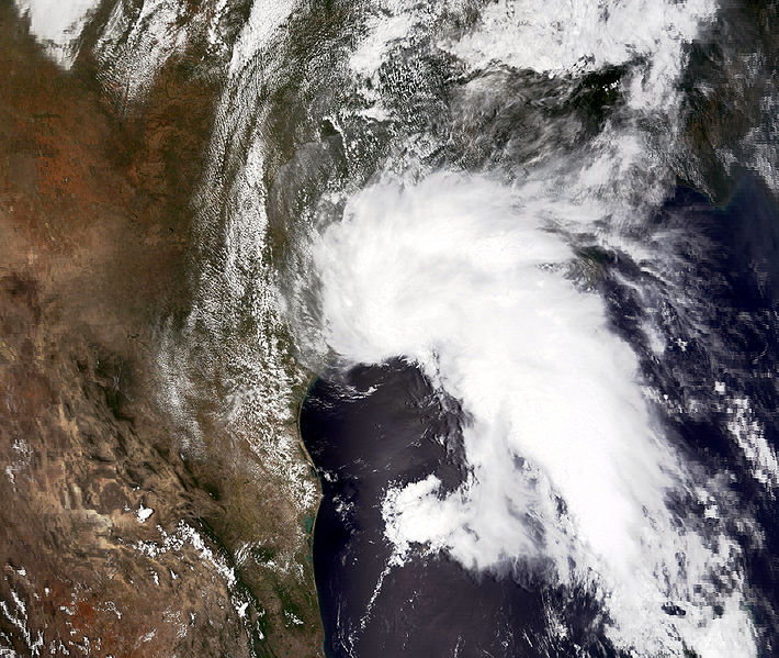
Gulf of Mexico Disturbance--PGI37L
Moderator: S2k Moderators
Forum rules

The posts in this forum are NOT official forecasts and should not be used as such. They are just the opinion of the poster and may or may not be backed by sound meteorological data. They are NOT endorsed by any professional institution or STORM2K. For official information, please refer to products from the National Hurricane Center and National Weather Service.
-
Stormcenter
- S2K Supporter

- Posts: 6689
- Joined: Wed Sep 03, 2003 11:27 am
- Location: Houston, TX

-
Frank P
- S2K Supporter
- Posts: 2779
- Joined: Fri Aug 29, 2003 10:52 am
- Location: Biloxi Beach, Ms
- Contact:
Re: Gulf of Mexico Disturbance--PGI37L
I've gotten more weather from this no nothing system today than I got from the TD 5 double header that visited us twice... It's very tropical in Biloxi today... just had a nice little squall line come thru.. breezy and rain.. sweet...
0 likes
-
Dean4Storms
- S2K Supporter
- Posts: 6358
- Age: 63
- Joined: Sun Aug 31, 2003 1:01 pm
- Location: Miramar Bch. FL

Raining now in downtown N.O. and a little breezy.
>>One thing that may work in our favor is the "wave train" and the pattern being established by these CV storms. Each will continue to leave a weakness which the succeeding storm would likely follow. Maybe the Bermuda high doesn't build back in.
This is an oversimplification that a lot of people latch onto, but it's not really the case even though sometimes it works that way (more likely toward the end of the season). Earl will only follow Danielle in as much as the pattern allows for recurvature - but farther west. Often in the wake of tropical systems, high pressure will build back with a vengence (not going to happen just yet), sometimes it will erode.
Pattern hasn't even flipped yet to ridge "on" in the Northeast U.S. Check out the 384 run of the ECMWF at 500mb to see where it sees us heading. If you don't believe that, check out the GFS at 200mb. True, the NAO isn't going to be a player yet and does not indicate where the season is heading. And after a bit of deterioration in the short-term (following Earl and 97L/Fiona-to-be) some reinforcments to western Atlantic high pressure will come courtesy of Eastern Canada. Bank on that. What we don't know is how strong or how long any of that will last. That's the beauty of sports that aren't fixed and the weather. It's going to be an interesting 4-6 weeks. FWIW, European long-range shows the pressures really falling toward the Gulf and Caribbean. No way we can tell who gets nailed, but its' coming. I personally guarantee many scary moments of model and wobble watching coming to a pc near us all.
0 likes

Re: Gulf of Mexico Disturbance--PGI37L
With this amount of upper divergence, couldn't a anti-cyclone develop over this? Possibly lowering the shear?

0 likes
-
Stormcenter
- S2K Supporter
- Posts: 6689
- Joined: Wed Sep 03, 2003 11:27 am
- Location: Houston, TX
Not saying anything is going to develop here but the area is starting to have that look to it.
http://www.ssd.noaa.gov/goes/east/gmex/loop-vis.html
http://www.ssd.noaa.gov/goes/east/gmex/loop-vis.html
0 likes


Re: Gulf of Mexico Disturbance--PGI37L
Greg...is this convection heading W/NW towards SETX or is the tail end of the frontal passage all we're going to get? I keep hearing it is headed W/NW, but you are the only MTR forecasting decent precip for Sunday. NWS is forecasting barely any rain for us. I'm confused...
0 likes

Re: Gulf of Mexico Disturbance--PGI37L
I 'm gonna take a guess that a low mabe forming south of the mouth of the Miss. river, because if look closely at the Hi-res. visible loop you see that the eddy(swirl) south of Morgan City is rotating around something to the SE in the heavier convection. Just my guess and it's not at the surface yet but is getting all in the inflow. should be a wet weekend for us in SE La.
Last edited by tailgater on Fri Aug 27, 2010 2:30 pm, edited 1 time in total.
0 likes
The following post is NOT an official forecast and should not be used as such. It is just the opinion of the poster and may or may not be backed by sound meteorological data. It is NOT endorsed by any professional institution including storm2k.org For Official Information please refer to the NHC and NWS products.
-
MGC

- S2K Supporter
- Posts: 5940
- Joined: Sun Mar 23, 2003 9:05 pm
- Location: Pass Christian MS, or what is left.
Re: Gulf of Mexico Disturbance--PGI37L
Looks to me that a weak low has formed near the Louisiana coast......MGC
0 likes
-
Dean4Storms
- S2K Supporter
- Posts: 6358
- Age: 63
- Joined: Sun Aug 31, 2003 1:01 pm
- Location: Miramar Bch. FL
This buoy raises my suspicion for sure, south of the central LA coast. Pressure dropping and winds sustained near 30mph.
http://www.ndbc.noaa.gov/station_page.php?station=42362
http://www.ndbc.noaa.gov/station_page.php?station=42362
0 likes
-
srainhoutx

- S2K Supporter
- Posts: 6919
- Age: 68
- Joined: Sun Jan 14, 2007 11:34 am
- Location: Haywood County, NC
- Contact:
Re:
Dean4Storms wrote:This buoy raises my suspicion for sure, south of the central LA coast. Pressure dropping and winds sustained near 30mph.
http://www.ndbc.noaa.gov/station_page.php?station=42362
Anemometer height: 122 m above site elevation
Barometer elevation: 37 m above mean sea level
0 likes
Carla/Alicia/Jerry(In The Eye)/Michelle/Charley/Ivan/Dennis/Katrina/Rita/Wilma/Ike/Harvey
Member: National Weather Association
Wx Infinity Forums
http://wxinfinity.com/index.php
Facebook.com/WeatherInfinity
Twitter @WeatherInfinity
Member: National Weather Association
Wx Infinity Forums
http://wxinfinity.com/index.php
Facebook.com/WeatherInfinity
Twitter @WeatherInfinity
-
greg_kfdm_tv
- Professional-Met

- Posts: 110
- Joined: Fri Aug 29, 2003 8:50 pm
- Location: Beaumont, Texas
- Contact:
Re: Gulf of Mexico Disturbance--PGI37L
djmikey wrote:Greg...is this convection heading W/NW towards SETX or is the tail end of the frontal passage all we're going to get? I keep hearing it is headed W/NW, but you are the only MTR forecasting decent precip for Sunday. NWS is forecasting barely any rain for us. I'm confused...
I would expect the trough axis, which extends from near the mouth of the Mississippi to the Mexican coast south of Brownsville, to shift slowly westward toward the Texas coast this weekend.
A few showers will be possible Saturday evening with a better risk Sunday. Not expecting any development and rainfall totals should stay less than two inches in a 24 hour period.
0 likes
Re: Gulf of Mexico Disturbance--PGI37L
greg_kfdm_tv wrote:djmikey wrote:Greg...is this convection heading W/NW towards SETX or is the tail end of the frontal passage all we're going to get? I keep hearing it is headed W/NW, but you are the only MTR forecasting decent precip for Sunday. NWS is forecasting barely any rain for us. I'm confused...
I would expect the trough axis, which extends from near the mouth of the Mississippi to the Mexican coast south of Brownsville, to shift slowly westward toward the Texas coast this weekend.
A few showers will be possible Saturday evening with a better risk Sunday. Not expecting any development and rainfall totals should stay less than two inches in a 24 hour period.
Thanks Greg!
0 likes


Re: Gulf of Mexico Disturbance--PGI37L
MGC wrote:Looks to me that a weak low has formed near the Louisiana coast......MGC
Same.
0 likes
-
Stormcenter
- S2K Supporter
- Posts: 6689
- Joined: Wed Sep 03, 2003 11:27 am
- Location: Houston, TX
Shear is our friend this season in the GOM.
If it were not for the shear we'd have big problems
with this. IMO
http://www.rap.ucar.edu/weather/satelli ... uration=12
If it were not for the shear we'd have big problems
with this. IMO
http://www.rap.ucar.edu/weather/satelli ... uration=12
0 likes
-
Bailey1777
- S2K Supporter
- Posts: 962
- Joined: Mon Jul 31, 2006 6:23 pm
- Location: Houston, Texas
Re: Gulf of Mexico Disturbance--PGI37L
why is developement not expected. it seems like storms are persisting
0 likes
-
srainhoutx
- S2K Supporter
- Posts: 6919
- Age: 68
- Joined: Sun Jan 14, 2007 11:34 am
- Location: Haywood County, NC
- Contact:
Re: Gulf of Mexico Disturbance--PGI37L
AREA FORECAST DISCUSSION
NATIONAL WEATHER SERVICE NEW ORLEANS LA
307 PM CDT FRI AUG 27 2010
.SYNOPSIS...
UPPER SHEAR AXIS AND SURFACE WARM FRONT EXTEND FROM NORTHERN GULF
OF MEXICO SOUTH OF MORGAN CITY...TO LAKE PONTCHARTRAIN...TO NORTH
OF MOBILE AT 19Z. WINDS OUT OF THE SOUTH TO THE SOUTH OF THE
BOUNDARY...AND LIGHT EAST TO NORTHEAST THE NORTH OF THE BOUNDARY.
A CIRCULATION CENTER IS APPARENT ON RADAR ABOUT 60NM TO THE SOUTH
OF MORGAN CITY...MOVING WEST. ISOLATED THUNDERSTORMS DETECTED FROM
PASCAGOULA TO NEW ORLEANS TO THIBODAUX WITH ONE OF THE BANDS.
&&
.SHORT TERM...
MORNING PRECIPITABLE WATER WAS 1.86 AT LIX...AND THIS WAS NORTH OF
THE BOUNDARY...WITH SOUNDER INDICATING 2.0 TO 2.5 INCHES TO THE
SOUTH OF THE BOUNDARY. MODELS ARE CONSISTENT IN LEAVING THE SHEAR
AXIS AND FRONTAL BOUNDARY OVER THE AREA THROUGH ABOUT 36 HOURS
BEFORE DRIFTING NORTHWARD AND GETTING PICKED UP IN THE WESTERLIES.
WITH LITTLE CHANGE IN THE BOUNDARY CONDITIONS OVER THE NEXT 3-4
PERIODS...THROUGH SATURDAY NIGHT AND SUNDAY...EXPECT SCATTERED TO
NUMEROUS SHOWERS AND THUNDERSTORMS TO AGAIN OCCUR ON SATURDAY AND
SUNDAY. THE MAIN TIME OF OCCURRENCE WILL AGAIN BE THE DIURNALLY
FAVORED AFTERNOON AND EVENING HOURS OVER LAND. LOCALLY HEAVY
RAINFALL IS EXPECTED...BUT SHOULD NOT BE WIDESPREAD AT ANY ONE
TIME. SLIGHTLY LOWER POPS ON MONDAY AS UPPER IMPULSE MOVES OFF TO
THE NORTHEAST. TEMPERATURES SHOULD BE NEAR NORMAL THROUGH THE
WEEKEND. 35
0 likes
Carla/Alicia/Jerry(In The Eye)/Michelle/Charley/Ivan/Dennis/Katrina/Rita/Wilma/Ike/Harvey
Member: National Weather Association
Wx Infinity Forums
http://wxinfinity.com/index.php
Facebook.com/WeatherInfinity
Twitter @WeatherInfinity
Member: National Weather Association
Wx Infinity Forums
http://wxinfinity.com/index.php
Facebook.com/WeatherInfinity
Twitter @WeatherInfinity
Who is online
Users browsing this forum: AnnularCane, cycloneye and 227 guests