2016 Global Model Runs Discussion (Out to Day 16)
Moderator: S2k Moderators
Forum rules

The posts in this forum are NOT official forecasts and should not be used as such. They are just the opinion of the poster and may or may not be backed by sound meteorological data. They are NOT endorsed by any professional institution or STORM2K. For official information, please refer to products from the National Hurricane Center and National Weather Service.
-
Blown Away

- S2K Supporter

- Posts: 10253
- Joined: Wed May 26, 2004 6:17 am
Re: 2016 Global Model Runs Discussion
These named 50-60 mph, is it tropical or nontropical, type systems are becoming the norm in the Atlantic basin... 
0 likes
Hurricane Eye Experience: David 79, Irene 99, Frances 04, Jeanne 04, Wilma 05… Hurricane Brush Experience: Andrew 92, Erin 95, Floyd 99, Matthew 16, Irma 17, Ian 22, Nicole 22…
-
1900hurricane

- Category 5

- Posts: 6063
- Age: 34
- Joined: Fri Feb 06, 2015 12:04 pm
- Location: Houston, TX
- Contact:
Re: 2016 Global Model Runs Discussion
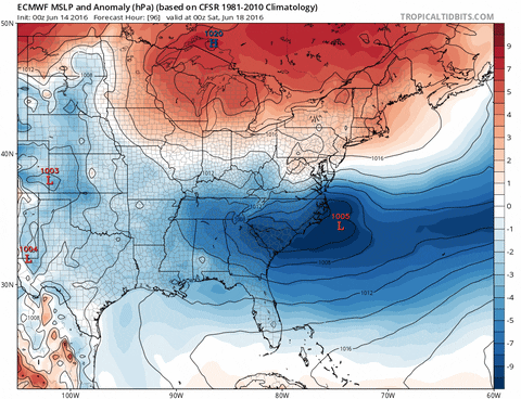
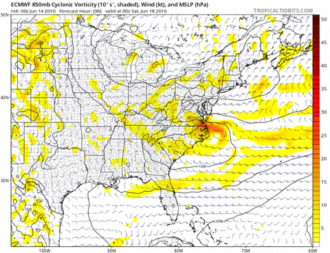
Not sold that the system on the 00Z ECMWF is anything other than extratropical. The same run shows a local minimum of 1000-500 mb thickness directly over the system's center, typical of an occluded low. 850 mb temps are also pretty chilly (<10*C) with the system, which is noticeably colder than the surrounding environment.

Last edited by 1900hurricane on Mon Jun 13, 2016 8:07 am, edited 1 time in total.
0 likes
Contract Meteorologist. TAMU & MSST. Fiercely authentic, one of a kind. We are all given free will, so choose a life meant to be lived. We are the Masters of our own Stories.
Opinions expressed are mine alone.
Follow me on Twitter at @1900hurricane : Read blogs at https://1900hurricane.wordpress.com/
Opinions expressed are mine alone.
Follow me on Twitter at @1900hurricane : Read blogs at https://1900hurricane.wordpress.com/
-
crownweather

- S2K Supporter
- Posts: 602
- Age: 51
- Joined: Sat Aug 12, 2006 9:21 am
- Location: Sturbridge, Massachusetts
- Contact:
Re: 2016 Global Model Runs Discussion
Just noticed this Tweet & thought I would share -
Michael Ventrice @MJVentrice 5m5 minutes ago
Big news in world of weather: In 2018-2019, NOAA is planning to replace the GFS, and the dynamic core of the CFS/GEFS #hope
4 retweets 5 likes
Michael Ventrice @MJVentrice 5m5 minutes ago
Big news in world of weather: In 2018-2019, NOAA is planning to replace the GFS, and the dynamic core of the CFS/GEFS #hope
4 retweets 5 likes
0 likes
Rob Lightbown
Crown Weather Services
https://crownweather.com
Crown Weather Services
https://crownweather.com
Re: 2016 Global Model Runs Discussion
crownweather wrote:Just noticed this Tweet & thought I would share -
Michael Ventrice @MJVentrice 5m5 minutes ago
Big news in world of weather: In 2018-2019, NOAA is planning to replace the GFS, and the dynamic core of the CFS/GEFS #hope
4 retweets 5 likes
Its been known for a while that the GFS is almost done. There is question (and a heated debate at times) which model NOAA will select. Heres a blog by Cliff Mass in which you can clearly see which side he favors.
http://cliffmass.blogspot.com/2016/03/t ... lects.html
0 likes
-
wxman57

- Moderator-Pro Met

- Posts: 23173
- Age: 68
- Joined: Sat Jun 21, 2003 8:06 pm
- Location: Houston, TX (southwest)
Re: 2016 Global Model Runs Discussion
It's clear that the Euro develops the low on a cold front this Saturday. But by Sunday, it appears to detach from the front. I do think that there's a greater than 50% chance this will be Danielle (TS, not STS).
0 likes


Re: 2016 Global Model Runs Discussion
Hello all, I've been a guest for about four years and it's been awesome. It feels great finally to be a member. I've learned a lot from you guys and I appreciate y'all's insight. This season seems to be off to an interesting start so far with Danielle possible this weekend.
Last edited by JaxGator on Mon Jun 13, 2016 10:44 am, edited 1 time in total.
0 likes
The posts or stuff said are NOT an official forecast. Please look to the NHC and NWS for official forecasts and products.
Floyd-1999, Frances-2004, Jeanne-2004, Fay-2008, Beryl-2012, Debby-2012, Colin-2016, Hermine-2016, Julia-2016, Matthew-2016, Irma-2017, Elsa-2021, Idalia-2023, Debby-2024, Helene-2024.
Go Gators! Go Jags!
Floyd-1999, Frances-2004, Jeanne-2004, Fay-2008, Beryl-2012, Debby-2012, Colin-2016, Hermine-2016, Julia-2016, Matthew-2016, Irma-2017, Elsa-2021, Idalia-2023, Debby-2024, Helene-2024.
Go Gators! Go Jags!
-
OuterBanker
- S2K Supporter
- Posts: 1761
- Joined: Wed Feb 26, 2003 10:53 am
- Location: Nags Head, NC
- Contact:
Re: 2016 Global Model Runs Discussion
Both models becoming more consistent. Both different as usual. Euro develops something on the front as it exits the DelMarVa. And detaches from the front, heading NW into Boston. By contrast the GFS has the low much further south exiting the NC coast. It elongates the low after meandering for a while and heads out to sea. Euro is usually right. I am skeptical of anything that develops north of 35 though.
0 likes

Re: 2016 Global Model Runs Discussion
wxman57 wrote:It's clear that the Euro develops the low on a cold front this Saturday. But by Sunday, it appears to detach from the front. I do think that there's a greater than 50% chance this will be Danielle (TS, not STS).
But by Sunday the Euro shows the system to be moving over SSTs well into the 60s.
This afternoon I am now thinking that this will not even be a subtropical system with the mid and upper level low pretty much on top of it, its cloud cover forecast also shows the classic look of an extra tropical system, no way this will be tropical. IMHO.
0 likes
Re: 2016 Global Model Runs Discussion
OuterBanker wrote:Both models becoming more consistent. Both different as usual. Euro develops something on the front as it exits the DelMarVa. And detaches from the front, heading NW into Boston. By contrast the GFS has the low much further south exiting the NC coast. It elongates the low after meandering for a while and heads out to sea. Euro is usually right. I am skeptical of anything that develops north of 35 though.
12z Euro actually shows that between 12z Sunday and 12z Monday the low will meander around between Delaware and Long Island doing at least one loop before moving ashore near Long Island, quickly falling apart.
0 likes
-
TheStormExpert
Re: 2016 Global Model Runs Discussion
For two runs now the GFS has been showing that same low moving into the FL/GA Coast in about a week although very weak. No between the models consistency whatsoever.
0 likes
-
stormwise

Re: 2016 Global Model Runs Discussion
Impressive wave off Africa so far but only the GFS develops it into something on this run (18z) but for now, shear appears to be low just to the west of the wave. Somehow, I can't post the images of the model run or the shear map.
Personal Forecast Disclaimer:
The posts in this forum are NOT official forecast and should not be used as such. They are just the opinion of the poster and may or may not be backed by sound meteorological data. They are NOT endorsed by any professional institution or storm2k.org. For official information, please refer to NHC and NWS products.
0 likes
The posts or stuff said are NOT an official forecast. Please look to the NHC and NWS for official forecasts and products.
Floyd-1999, Frances-2004, Jeanne-2004, Fay-2008, Beryl-2012, Debby-2012, Colin-2016, Hermine-2016, Julia-2016, Matthew-2016, Irma-2017, Elsa-2021, Idalia-2023, Debby-2024, Helene-2024.
Go Gators! Go Jags!
Floyd-1999, Frances-2004, Jeanne-2004, Fay-2008, Beryl-2012, Debby-2012, Colin-2016, Hermine-2016, Julia-2016, Matthew-2016, Irma-2017, Elsa-2021, Idalia-2023, Debby-2024, Helene-2024.
Go Gators! Go Jags!
-
TheStormExpert
Re: 2016 Global Model Runs Discussion
00z Euro shows it becoming subtropical @ hr. 144, then tropical very briefly @ hr. 168. The 00z GFS on the other hand shows a very weak low moving into SC @ hr. 132.

0 likes
Re: 2016 Global Model Runs Discussion
0z Euro is further south with the area of low pressure, so is more believable on this run that the system could acquire subtropical and or tropical characteristics as it sits over the warm gulf stream east of N.C./Mid Atlantic area.
0 likes

Re: 2016 Global Model Runs Discussion
NDG wrote:0z Euro is further south with the area of low pressure, so is more believable on this run that the system could acquire subtropical and or tropical characteristics as it sits over the warm gulf stream east of N.C./Mid Atlantic area.
Not to put much stock into everyone's crazy Uncle Gem (Canadian model), but it's appearing to be more or less on board with the EURO at about 132 hours. Granted at a latitude closer to about 40N, but still showing what now appears as a briefly tropical low that swings back toward Long Island before stalling and weakening, then being pulled into the Westerlies on the way out.
On a different but related note, the GEM is showing for the second straight run, a tropical storm also developing in the S. Gulf and moves it into Brownsville. I know.... I know, minimal model support for a Gulf system and its the GEM lol, but I will say this much, not only does there seem to be some of the (GEFS) ensemble members showing possible support for this area, but to me appears to better fit both climatolody and the dynamic set up with a fairly strong surface high over the South/Central Plains to its north. In fact, the Navy (NAVGEM) too, is fully picking up and trending more vigorous on a low coming off Yucatan into the S. Central Gulf at 144 hour as well.
0 likes
Andy D
(For official information, please refer to the NHC and NWS products.)
(For official information, please refer to the NHC and NWS products.)
Re: 2016 Global Model Runs Discussion
The differences between the Euro and GFS when it comes to this cutoff low are staggering. The GFS has a 594 ridge where the Euro has a 564 cutoff low.
0 likes
Re: 2016 Global Model Runs Discussion
RL3AO wrote:The differences between the Euro and GFS when it comes to this cutoff low are staggering. The GFS has a 594 ridge where the Euro has a 564 cutoff low.
Very true, though in my opinion and under more typical tropical conditions, could be somewhat compared to a northward moving tropical storm approaching a strong banana shaped ridge extending east from the Carolina's. I'm not suggesting that GFS isnt overplaying the 500mb heights or somewhat displaced this ridge itself, but either way the EURO is also suggesting some East coast ridging to cause a briefly transitioning T.S. to curl back westward. Obvious problem that the GFS is having is not only related to its lesser forecast surface ressure falls with this cutoff, but I think moreso not picking up on the transitioning upper level conditions which would seemingly support short term tropical development of the cutoff that the EURO is showing.
I have a feeling that the GFS will be coming around a bit more in line with the EURO within the next 12 hours. I was taking a long look at the past four runs of the GFS forecast 200mb pattern. There seems to be a fairly significant pattern change from GFS models when compared to the 6Z run. The 6Z run shows a distinctly more ridging pattern building over the Four Corners' region as well as off the US East coastline. Not only did this imply more obvious upper air conditions as it may apply to this transitional tropical cut off, but the previously forecasted pooling of Westerlies to a broad trough down the Eastern seaboard, to suddenly becoming replaced with a northward building upper level ridge. This increased upper level ridging also now also seem to be less supressing a 200 mb anticlyclone over the Yucatan and Southern Gulf from about 130-170hrs. No doubt we might see this updating GFS 12Z better exhibit some similarity and in line with the EURO regarding development of an East coast hybrid system. I also think the GFS might begin trending toward a S. Gulf development more or less during the same time period. At least that's what I'm beginning to anticipate might play out.
0 likes
Andy D
(For official information, please refer to the NHC and NWS products.)
(For official information, please refer to the NHC and NWS products.)
Re: 2016 Global Model Runs Discussion
Hmmm, Well it looks like at least up to 120 hours the 12Z GFS is holding steadfast on taking a pair of cut-offs and just moving them eastward off the Carolina coast, weakening with time. Still looking to see if perhaps another cut-off might enter the picture and try to develop in line with the 0Z Euro. Something's gotta give soon though. Hmmm, could it be the EURO that might prove to "bust" on this one (stiring the pot  )??
)??
0 likes
Andy D
(For official information, please refer to the NHC and NWS products.)
(For official information, please refer to the NHC and NWS products.)
-
tropicwatch

- Category 5
- Posts: 3426
- Age: 62
- Joined: Sat Jun 02, 2007 10:01 am
- Location: The Villages, Florida
- Contact:
Re: 2016 Global Model Runs Discussion
Noticed the GFS indicating a low close to the northern Gulf Coast this weekend. Though it doesn't suggest development, a low in the northern gulf can become interesting to watch if it hangs around.
Last edited by tropicwatch on Tue Jun 14, 2016 1:00 pm, edited 1 time in total.
0 likes
Tropicwatch
Agnes 72', Eloise 75, Elena 85', Kate 85', Charley 86', Florence 88', Beryl 94', Dean 95', Erin 95', Opal 95', Earl 98', Georges 98', Ivan 2004', Arlene 2005', Dennis 2005', Ida 2009' Debby 2012' Irma 2017' Michael 2018'
Agnes 72', Eloise 75, Elena 85', Kate 85', Charley 86', Florence 88', Beryl 94', Dean 95', Erin 95', Opal 95', Earl 98', Georges 98', Ivan 2004', Arlene 2005', Dennis 2005', Ida 2009' Debby 2012' Irma 2017' Michael 2018'
Re: 2016 Global Model Runs Discussion
Well, GFS 12Z run and no East coast storm consensus. GFS suggesting  , to the EURO in respect to a cutoff developing into a hybrid system.
On another note and something I thought this morning might be taking place, has the GFS now developing a 1010mb Low/Tropical depression (?) down in the southern Gulf at about 144 hours. This under an expanding upper anticyclone. In spite of this however, the model seems to slowly slide this feature inland near or north of Veracruz. I'm thinking however that this feature might continue to trend stronger with future GFS runs. I'd be surprised if the EURO picked up on this anytime soon given its small relative size however.
, to the EURO in respect to a cutoff developing into a hybrid system.On another note and something I thought this morning might be taking place, has the GFS now developing a 1010mb Low/Tropical depression (?) down in the southern Gulf at about 144 hours. This under an expanding upper anticyclone. In spite of this however, the model seems to slowly slide this feature inland near or north of Veracruz. I'm thinking however that this feature might continue to trend stronger with future GFS runs. I'd be surprised if the EURO picked up on this anytime soon given its small relative size however.
0 likes
Andy D
(For official information, please refer to the NHC and NWS products.)
(For official information, please refer to the NHC and NWS products.)
Who is online
Users browsing this forum: No registered users and 197 guests