
Looks like the heaviest convection is just west of Martinique and Dominica.HURAKAN wrote:
Perturbed Area over Lesser Antilles (Is Invest 93L)
Moderator: S2k Moderators
Forum rules

The posts in this forum are NOT official forecasts and should not be used as such. They are just the opinion of the poster and may or may not be backed by sound meteorological data. They are NOT endorsed by any professional institution or STORM2K. For official information, please refer to products from the National Hurricane Center and National Weather Service.
-
Gustywind

- Category 5

- Posts: 12334
- Joined: Mon Sep 03, 2007 7:29 am
- Location: Baie-Mahault, GUADELOUPE
Re: Little Perturbed Area east of Martinica trying to organize?
cycloneye wrote:The action looks like its all on top of you guys in Guadeloupe.What observations you can see about this bad weather there?
http://www.meteo.fr/temps/domtom/antill ... Tagant.jpg
Oh yeah this blob has exploxed this morning at 4am, all the islands should experience wet and unstelled weather conditions, and especially Guadeloupe, surely on the "heart" of this perturbed area!
Hi Cycloneye, things are deteriorating here as we're right now in ORANGE alert by our Pro-Met of Meteo-France for a real ans strong risk of strong showers added to thunderstorms!
I translate you the latest weather forecast of Meteo-France for Guadeloupe
SynopsisAn important perturbed area is concerning us actively since the night before with persisting rains sometimes with strong intensity.
ForecastsFor at least the next 36 hours, a type of rainy weather, with frequents rainshowers should be on tape, with briefs periods of calm.
Data and numbers
120 millimeters have been reported at Marie-Galante( Guadeloupe) for the night and more than 50 to 60 millimeters in others locations of Guadeloupe.
We could expect importants amounts of rain during this episode who will stay, stall for good moment...
More than the risk of abundants rains gustywinds ( not me
In definitive with this strong risk of strong showers this last hours, and this persistent perturbed area on our island of Guadeloupe, the orange alert is neccesary!
The episode should stay at least Friday on the island, next weather forecast at 12 am.
Hope i'm informative for you, i do my best on this, enjoy it!
Nice regards from the butterfly island, Gustywind
0 likes
-
HURAKAN

- Professional-Met

- Posts: 46084
- Age: 39
- Joined: Thu May 20, 2004 4:34 pm
- Location: Key West, FL
- Contact:
In the loop you can clearly see the upper level clouds moving east and the LL clouds moving west. Shear is winning.
Loop: http://www.ssd.noaa.gov/goes/east/carb/loop-vis.html
Loop: http://www.ssd.noaa.gov/goes/east/carb/loop-vis.html
0 likes
-
Gustywind
- Category 5
- Posts: 12334
- Joined: Mon Sep 03, 2007 7:29 am
- Location: Baie-Mahault, GUADELOUPE
Re:
HURAKAN wrote:In the loop you can clearly see the upper level clouds moving east and the LL clouds moving west. Shear is winning.
Loop: http://www.ssd.noaa.gov/goes/east/carb/loop-vis.html
Tkanks Hurakan for the nice observation, but i like this type of win without any circulation on Guadeloupe and the others islands in vicinity
0 likes
-
Gustywind
- Category 5
- Posts: 12334
- Joined: Mon Sep 03, 2007 7:29 am
- Location: Baie-Mahault, GUADELOUPE
http://www.meteo.fr/temps/domtom/antill ... Tagant.jpg
TROPICAL WEATHER DISCUSSION
NWS TPC/NATIONAL HURRICANE CENTER MIAMI FL
805 AM EDT THU SEP 18 2008
TROPICAL WEATHER DISCUSSION FOR NORTH AMERICA...CENTRAL
AMERICA...GULF OF MEXICO...CARIBBEAN SEA...NORTHERN SECTIONS
OF SOUTH AMERICA...AND ATLANTIC OCEAN TO THE AFRICAN COAST
FROM THE EQUATOR TO 32N. THE FOLLOWING INFORMATION IS BASED
ON SATELLITE IMAGERY...METEOROLOGICAL ANALYSIS...WEATHER
OBSERVATIONS...AND RADAR.
BASED ON 0600 UTC SURFACE ANALYSIS AND SATELLITE IMAGERY THROUGH
1015 UTC.
...DISCUSSION...
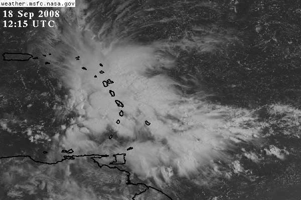
AN UPPER LEVEL LOW IS CENTERED N OF THE LEEWARD ISLANDS NEAR 22N64W. DIFFLUENCE E OF THE CENTER IS PRODUCING AN IMPRESSIVE AREA OF SCATTERED MODERATE TO STRONG CONVECTION OVER THE LEEWARD ISLANDS FROM 14N-20N
BETWEEN 58W-64W.
TROPICAL WEATHER DISCUSSION
NWS TPC/NATIONAL HURRICANE CENTER MIAMI FL
805 AM EDT THU SEP 18 2008
TROPICAL WEATHER DISCUSSION FOR NORTH AMERICA...CENTRAL
AMERICA...GULF OF MEXICO...CARIBBEAN SEA...NORTHERN SECTIONS
OF SOUTH AMERICA...AND ATLANTIC OCEAN TO THE AFRICAN COAST
FROM THE EQUATOR TO 32N. THE FOLLOWING INFORMATION IS BASED
ON SATELLITE IMAGERY...METEOROLOGICAL ANALYSIS...WEATHER
OBSERVATIONS...AND RADAR.
BASED ON 0600 UTC SURFACE ANALYSIS AND SATELLITE IMAGERY THROUGH
1015 UTC.
...DISCUSSION...
AN UPPER LEVEL LOW IS CENTERED N OF THE LEEWARD ISLANDS NEAR 22N64W. DIFFLUENCE E OF THE CENTER IS PRODUCING AN IMPRESSIVE AREA OF SCATTERED MODERATE TO STRONG CONVECTION OVER THE LEEWARD ISLANDS FROM 14N-20N
BETWEEN 58W-64W.
0 likes
-
Gustywind
- Category 5
- Posts: 12334
- Joined: Mon Sep 03, 2007 7:29 am
- Location: Baie-Mahault, GUADELOUPE
000
FXCA62 TJSJ 180854
AFDSJU
AREA FORECAST DISCUSSION
NATIONAL WEATHER SERVICE SAN JUAN PR
454 AM AST THU SEP 18 2008
.SYNOPSIS...
AN UPPER-LEVEL TROUGH (TUTT) EXTENDS FROM A LOW LOCATED NEAR 22N
67W...SOUTHWARDS ACROSS PUERTO RICO THEN INTO THE EASTERN CARIBBEAN.
THE STRONG SOUTHWESTERLY FLOW EAST OF THIS TROUGH AXIS CONTINUED TO
TRANSPORT MOIST TROPICAL AIR ACROSS LESSER ANTILLES BRINGING CONSIDERABLE
AMOUNTS OF MID TO UPPER LEVEL CLOUDINESS ACROSS AND TO THE EAST OF THE
ISLAND CHAIN. IN THE LOW LEVELS MOISTURE ENHANCED BY THE UPPER LEVEL
TUTT AND TRAILING A TROPICAL WAVE NOW LOCATED NEAR NEAR 69 WEST WILL
CONTINUE TO MOVE ACROSS THE NORTHEAST CARIBBEAN AND AFFECT THE LOCAL
AREA TODAY THROUGH FRIDAY.
&&
.DISCUSSION...
UPPER LEVEL TROUGH ACROSS THE REGION HELPING TO MAINTAIN VERY UNSTABLE
CONDITIONS ACROSS THE REGION AND INDUCING CONSIDERABLE AMOUNTS OF
CONVECTION ALONG THE TRAILING EDGE OF THE TROPICAL WAVE AXIS...WHICH
IS NOW MOVING ACROSS THE U.S. VIRGIN ISLANDS. LATEST GFS MODEL
GUIDANCE CONTINUED TO SUGGEST THAT THIS MOIST AND UNSTABLE
ENVIRONMENT WILL REMAIN IN PLACE ACROSS THE REGION THROUGH REST
OF THE WEEK...AS THE TUTT WILL LIFT NORTH NORTHWEST TO JUST NORTH
OF THE AREA. IN THE MEANTIME....THE BROAD LOW LEVEL TROUGHINESS
ACROSS THE EASTERN CARIBBEAN BASIN WILL HELP MAINTAIN A PREVAILING
EAST SOUTHEAST LOW LEVEL WIND FLOW WITH FAIR AMOUNTS OF ITCZ
MOISTURE EXPECTED TO BE LIFTED NORTHWARDS ACROSS THE LOCAL AREA.
BY SUNDAY...A BULGE (INDUCED TROUGHINESS) IN THE ITCZ WILL LIFT
NORTHWARD ACROSS THE LOCAL FORECAST AREA AND FURTHER INCREASE THE
THE CHANCES OF MORE ACTIVE WEATHER CONDITIONS DURING THE DAYTIME.
THE AVAILABLE MOISTURE COMBINED WITH THE PROXIMITY OF THE UPPER
LEVEL TROUGH JUST NORTH OF THE AREA...AND THE LOCAL AND DIURNAL
INFLUENCES WILL MAKE FOR MOSTLY ACTIVE WEATHER CONDITIONS FOR THE
REST OF THE WEEK AND WELL INTO THE WEEKEND.
&&
.AVIATION...
CLOUDINESS AND SHOWERS BEHIND A TROPICAL WAVE WHOSE AXIS IS
ACROSS THE MONA PASSAGE THIS MORNING WILL CONTINUE ACROSS THE
REGION PRODUCING TEMPORARY MVFR CONDITIONS ACROSS TKPK...TNCM...
TISX AND TIST UNTIL AT LEAST 16Z. FOR THE AFTERNOON HOURS...THIS
MOISTURE WILL TRACK WESTWARD ACROSS THE REST OF THE REGION...AND
WILL COMBINE WITH DIURNAL HEATING AND LOCAL EFFECTS...RESULTING IN
DIURNALLY DRIVEN CONVECTION ACROSS THE INTERIOR AND WESTERN
SECTIONS OF PUERTO RICO. THIS WILL RESULT IN MOUNTAIN OBSCURATIONS
AND PERIODS OF MVFR OR EVEN IFR CONDITIONS ACROSS TJSJ...TJPS...
TJMZ AND TJBQ FROM 17-23Z. LATEST TJSJ 00Z SOUNDING INDICATED A
LIGHT EAST TO SOUTHEAST WIND FLOW FROM THE SURFACE TO AROUND 6K
FEET...BECOMING MORE SOUTHERLY FROM 6-30K FEET.
&&
.MARINE...
OUTSIDE OF THE EXPECTED SHOWERS AND ISOLATED THUNDERSTORM ACTIVITY...
MARINERS CAN EXPECT WINDS OF 16 KNOTS OR LESS AND SEAS OF 4 FEET OR
LESS ACROSS THE REGIONAL WATERS TODAY.
&&
.PRELIMINARY POINT TEMPS/POPS...
SJU 88 78 88 77 / 50 50 40 40
STT 86 78 86 78 / 50 60 60 50
&&
.SJU WATCHES/WARNINGS/ADVISORIES...
PR...NONE.
VI...NONE.
&&
$$
72/09/
0 likes
-
Gustywind
- Category 5
- Posts: 12334
- Joined: Mon Sep 03, 2007 7:29 am
- Location: Baie-Mahault, GUADELOUPE
000
AWCA82 TJSJ 180934
RWSVI
WEATHER SUMMARY FOR THE U.S. VIRGIN ISLANDS
NATIONAL WEATHER SERVICE SAN JUAN PR
500 AM AST THU SEP 18 2008
A TROPICAL WAVE ACROSS THE MONA PASSAGE THIS MORNING...WILL CONTINUE
TO TRACK WESTWARD TODAY. A LARGE AREA OF CLOUDINESS...SHOWERS
AND THUNDERSTORMS...WELL EAST OF THE WAVE AXIS...IS LOCATED JUST
EAST OF THE U.S. VIRGIN ISLANDS THIS MORNING. THIS MOISTURE...
ENHANCED BY AN UPPER TROUGH OVER THE REGION...WILL MOVE WESTWARD
ACROSS THE LOCAL ISLANDS TODAY AND TONIGHT. THE COMBINATION OF THESE
FEATURES WITH LOCAL EFFECTS...IS FORECAST TO PRODUCE A GENERAL
INCREASE IN CLOUDINESS...SHOWERS AND THUNDERSTORMS OVER THE REGION
TODAY. THIS WET WEATHER PATTERN WILL PREVAIL ACROSS THE LOCAL
ISLANDS UNTIL AT LEAST SATURDAY.
0 likes
Re: Perturbed Area over Lesser Antilles trying to organize?
LOL, wind direction and speed are quite erratic this morning at the airport. Probably due to localized convective activity.
0 likes

-
Gustywind
- Category 5
- Posts: 12334
- Joined: Mon Sep 03, 2007 7:29 am
- Location: Baie-Mahault, GUADELOUPE
Winds are slighlty abating given the map shear, hope no more but this perturbed area should stall more than predicted...  let's see what happens as we're in the peak
  . No more changes here, always sad grey dark but the rain has diminshed it's little right now no wind no thunderstorms or lightnings..
0 likes
Re: Perturbed Area over Lesser Antilles trying to organize?
I'd be surprised if this didn't develop. You can see the upper level concave cut into the west side at the shear level, but in my view in prime season the convection flaring caused by this should draw in convergence and formation. Think we are looking at our next storm here. How many times have we seen yesterday's scattered dotted convection gell into a system in this area?
0 likes
-
gatorcane

- S2K Supporter

- Posts: 23708
- Age: 48
- Joined: Sun Mar 13, 2005 3:54 pm
- Location: Boca Raton, FL
Re: Perturbed Area over Lesser Antilles trying to organize?
As I said yesterday (look back at this thread before it got attention)...activate the bears!
and Luis did....
still conditions appear a bit hostile for rapid development
and Luis did....
still conditions appear a bit hostile for rapid development
0 likes
-
HURAKAN
- Professional-Met
- Posts: 46084
- Age: 39
- Joined: Thu May 20, 2004 4:34 pm
- Location: Key West, FL
- Contact:
Re: Perturbed Area over Lesser Antilles trying to organize?
Sanibel, development may occur after the TUTT leaves the area but I bet it's the TUTT that is providing for the convection to develop. Which means, no TUTT, likely, no convection. Yes, it's an impressive area of convection but first, there is nothing at the surface, there nearest tropical wave is at 70W, and second, conditions are not favorable for development.
Moreover, no pro-Met seems interested in the area as no one has commented on it.
Moreover, no pro-Met seems interested in the area as no one has commented on it.
0 likes
-
Stormcenter
- S2K Supporter
- Posts: 6689
- Joined: Wed Sep 03, 2003 11:27 am
- Location: Houston, TX
Re: Perturbed Area over Lesser Antilles trying to organize?
Sanibel wrote:I'd be surprised if this didn't develop. You can see the upper level concave cut into the west side at the shear level, but in my view in prime season the convection flaring caused by this should draw in convergence and formation. Think we are looking at our next storm here. How many times have we seen yesterday's scattered dotted convection gell into a system in this area?
If it does it's going to have a tough time throughout
it's lifespan.
0 likes
-
cycloneye

- Admin

- Posts: 149556
- Age: 69
- Joined: Thu Oct 10, 2002 10:54 am
- Location: San Juan, Puerto Rico
Re: Perturbed Area over Lesser Antilles trying to organize?
gatorcane wrote:As I said yesterday (look back at this thread before it got attention)...activate the bears!
and Luis did....
still conditions appear a bit hostile for rapid development
I posted the bears for a little fun,but I am with all what HURAKAN says.
0 likes


Who is online
Users browsing this forum: Google Adsense [Bot], Yellow Evan and 48 guests