GOM, homebrew?

This is the general tropical discussion area. Anyone can take their shot at predicting a storms path.

Moderator: S2k Moderators

Forum rules

The posts in this forum are NOT official forecasts and should not be used as such. They are just the opinion of the poster and may or may not be backed by sound meteorological data. They are NOT endorsed by any professional institution or STORM2K. For official information, please refer to products from the National Hurricane Center and National Weather Service.

Help Support Storm2K
Message
Author
RL3AO
Moderator-Pro Met
Moderator-Pro Met
Posts: 16308
Joined: Thu Jun 14, 2007 10:03 pm
Location: NC

#41 Postby RL3AO » Thu Sep 25, 2008 7:13 pm

Image

TROPICAL WEATHER OUTLOOK
NWS TPC/NATIONAL HURRICANE CENTER MIAMI FL
800 PM EDT THU SEP 25 2008

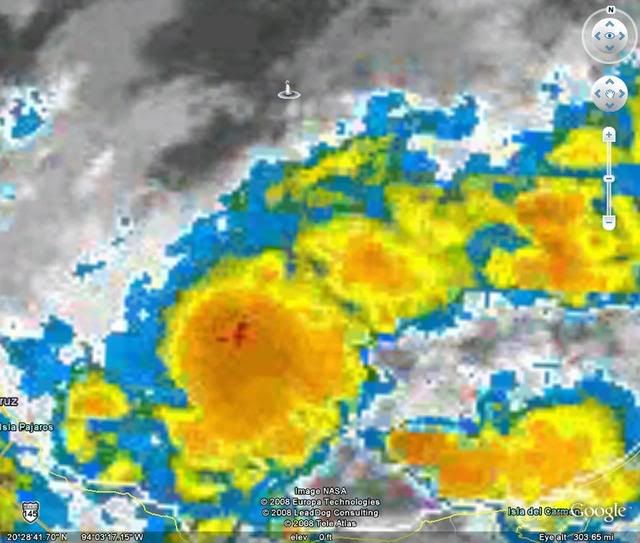
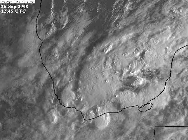
AN AREA OF DISTURBED WEATHER HAS FORMED IN THE BAY OF CAMPECHE.
THERE ARE NO SIGNS OF ORGANIZATION AT THIS TIME BUT THIS SYSTEM
COULD BRING HEAVY RAINS TO PORTIONS SOUTHERN MEXICO DURING THE NEXT
COUPLE OF DAYS.

FORECASTER AVILA/BERG


Not sure if this is what the thread was talking about, but I didn't want to start a new topic.
0 likes   

caneman

Re: GOM, homebrew?

#42 Postby caneman » Thu Sep 25, 2008 7:30 pm

This area sure has been festering for awhile. Not much if any model support but does bear watching this time of year.
0 likes   

User avatar
KatDaddy
Category 5
Category 5
Posts: 2815
Joined: Mon Oct 21, 2002 6:23 pm
Location: League City, Texas

#43 Postby KatDaddy » Thu Sep 25, 2008 9:18 pm

Joe B has been talking about the S GOM for a few days. He is good at long range patterns but not 5 days out. He has taken a beating this season I agree the overall pattern could support tropical development in the GOM but hopefully not. I will let the pro-Mets chime in on the GOM.
0 likes   

User avatar
HURAKAN
Professional-Met
Professional-Met
Posts: 46086
Age: 38
Joined: Thu May 20, 2004 4:34 pm
Location: Key West, FL
Contact:

Re: GOM, homebrew?

#44 Postby HURAKAN » Fri Sep 26, 2008 7:23 am

42055 - MARITIME-buoy
Friday Sep. 26 - 10:50 UTC
Air Temperature: 82°F
Dewpoint: 70°F
Wind: NNE at 29 mph
gusting to 34

Pressure: 1010.8 mb
Wave Height: 8 ft
Sea Surface Temp: 84.4°F

Image

Could we have a small area of low pressure that is intensifying?
0 likes   

User avatar
HURAKAN
Professional-Met
Professional-Met
Posts: 46086
Age: 38
Joined: Thu May 20, 2004 4:34 pm
Location: Key West, FL
Contact:

#45 Postby HURAKAN » Fri Sep 26, 2008 7:26 am

Coatzacoalcos, VZ, MX as of 2008-09-26 12:00 UTC:

Humidity: 78%
Wind: SW 12 mph
Pressure: 29.80 in.
Dewpoint: 68°F / 20°C
0 likes   

User avatar
HURAKAN
Professional-Met
Professional-Met
Posts: 46086
Age: 38
Joined: Thu May 20, 2004 4:34 pm
Location: Key West, FL
Contact:

#46 Postby HURAKAN » Fri Sep 26, 2008 7:58 am

Image
0 likes   

User avatar
gboudx
S2K Supporter
S2K Supporter
Posts: 4080
Joined: Thu Sep 04, 2003 1:39 pm
Location: Rockwall, Tx but from Harvey, La

Re:

#47 Postby gboudx » Fri Sep 26, 2008 9:24 am

KatDaddy wrote:Joe B has been talking about the S GOM for a few days. He is good at long range patterns but not 5 days out. He has taken a beating this season I agree the overall pattern could support tropical development in the GOM but hopefully not. I will let the pro-Mets chime in on the GOM.


Here's what Jeff Lidner said in his email update this morning about that area. No link.

Gulf of Mexico:

An area of disturbed weather has developed in the southern Gulf of Mexico and Bay of Campeche along the tail end of an old surface trough which extends from S FL to Mexico. While currently disorganized the system does have some potential for slow development if it can remain over the open waters of the Bay of Campeche. A few of the forecast models suggest lowering pressures in this region over the next several days and attempt to close off a surface low over the Yucatan. Given the upper pattern developing over the US…any development would be held in the southern Gulf for the next several days and then may be allowed to move northward of NNE toward the US Gulf coast late next week as large scale ridging in control of much of the US breaks down.
0 likes   

Sanibel
Category 5
Category 5
Posts: 10375
Joined: Mon Aug 30, 2004 11:06 pm
Location: Offshore SW Florida

Re: GOM, homebrew?

#48 Postby Sanibel » Fri Sep 26, 2008 10:57 am

Dry area to north should impede development.
0 likes   

User avatar
wxman57
Moderator-Pro Met
Moderator-Pro Met
Posts: 22985
Age: 67
Joined: Sat Jun 21, 2003 8:06 pm
Location: Houston, TX (southwest)

Re: GOM, homebrew?

#49 Postby wxman57 » Fri Sep 26, 2008 11:08 am

Here's a surface analysis as requested by HURAKAN. It's common for winds to accelerate down the coast of Mexico and into the BoC, forming an eddy at the trailing end of cold fronts. That's what we have now. It's something to keep an eye on, but winds aloft are quite hostile outside the southern BoC - 50 kts out of the west from Mexico to the northern Yucatan. Westerly winds aloft actually increase across the central BoC over the next 24 hours, so quite a bit of shear down there.

Image
0 likes   

Ed Mahmoud

Re: GOM, homebrew?

#50 Postby Ed Mahmoud » Fri Sep 26, 2008 11:33 am

Just looking at the shallower 2 CIMMS mean wind analyses, anything there should be drifting Southward now. Back into Mexico, possibly.


12Z WRF seems to imply that 500 mb steering will allow anything down there to start moving more Northeastward in a couple of days, and seems to actually show a feature coming up toward Florida, maybe bent back more Northerly by what might be a bit of the big East Coast trough breaking off and getting into the Northwest Gulf.


I will say, other than that one little fluke about two weeks ago, Texas has been in a Fall like pattern of Westerlies for almost a month, and now we have a nice continental surface airmass to go along with that.

Probably never develops, but if it does, I smell Florida.
0 likes   

User avatar
Tampa_God
Category 1
Category 1
Posts: 333
Age: 35
Joined: Wed May 31, 2006 7:27 pm
Location: New Port Richey/Trinity, FL

Re: GOM, homebrew?

#51 Postby Tampa_God » Fri Sep 26, 2008 3:29 pm

If anything does form, it will be dragged North eastward. The huge no name low will steer this thing either into the West Coast of Florida or towards the Panhandle/AL border.
0 likes   

tina25
Tropical Depression
Tropical Depression
Posts: 62
Joined: Mon Sep 01, 2008 10:53 pm
Location: NYC

Re: GOM, homebrew?

#52 Postby tina25 » Fri Sep 26, 2008 4:11 pm

From Jeff Masters latest blog..

Gulf of Mexico disturbance may threaten western Florida next week
An area of disturbed weather in the southern Gulf of Mexico, just west of Mexico's Yucatan Peninsula, has changed little today. Visible satellite images show a modest-sized area of heavy thunderstorms moving east-southeast, towards the Yucatan Peninsula. Wind shear is about 15 knots over the region, which is marginal for development. The system should move ashore over the Yucatan Peninsula by Saturday before development into a tropical depression can occur. NHC is giving this system a low (<20% chance) of developing into a tropical depression by Sunday. Early next week, we will have to watch the waters on either side of the Yucatan for possible development of this system. Some of the models are predicting that a tropical depression could form off the coast of the Yucatan Peninsula early next week, then move northeastwards to a landfall in western Florida as early as Wednesday.
0 likes   

Sanibel
Category 5
Category 5
Posts: 10375
Joined: Mon Aug 30, 2004 11:06 pm
Location: Offshore SW Florida

Re: GOM, homebrew?

#53 Postby Sanibel » Fri Sep 26, 2008 6:43 pm

Slight spin. Limited area of development under unfavorable northern GOM.

Could spin and head in our direction.
0 likes   

User avatar
Tampa Bay Hurricane
Category 5
Category 5
Posts: 5597
Age: 37
Joined: Fri Jul 22, 2005 7:54 pm
Location: St. Petersburg, FL

Re: GOM, homebrew?

#54 Postby Tampa Bay Hurricane » Sat Sep 27, 2008 12:09 am

Heavy Convection forming in the SE Gulf/NW Caribbean; This area is climatologically favored
for significant late season storms; The stationary
front that is fueling it will lift north
over central Florida by Monday, allowing a steering
flow to push whatever this becomes into South Florida
by Wednesday-Thursday.


Image
0 likes   

User avatar
boca
Category 5
Category 5
Posts: 6368
Age: 60
Joined: Mon Dec 15, 2003 8:49 am
Location: Boca Raton,FL

Re: GOM, homebrew?

#55 Postby boca » Sat Sep 27, 2008 12:23 am

Hey Tampa bay it looks like you saw the 00z GFS run it has a low moving NE towards the west coast of Florida by Wed timeframe.Good call.

http://www.nco.ncep.noaa.gov/pmb/nwprod ... loop.shtml
0 likes   

JonathanBelles
Professional-Met
Professional-Met
Posts: 11430
Age: 35
Joined: Sat Dec 24, 2005 9:00 pm
Location: School: Florida State University (Tallahassee, FL) Home: St. Petersburg, Florida
Contact:

#56 Postby JonathanBelles » Sat Sep 27, 2008 12:37 am

TITAN showed a low forming by monday-Tuesday and moving NE over FL.
0 likes   

User avatar
boca
Category 5
Category 5
Posts: 6368
Age: 60
Joined: Mon Dec 15, 2003 8:49 am
Location: Boca Raton,FL

Re:

#57 Postby boca » Sat Sep 27, 2008 12:40 am

fact789 wrote:TITAN showed a low forming by monday-Tuesday and moving NE over FL.


Do you have a link?
0 likes   

JonathanBelles
Professional-Met
Professional-Met
Posts: 11430
Age: 35
Joined: Sat Dec 24, 2005 9:00 pm
Location: School: Florida State University (Tallahassee, FL) Home: St. Petersburg, Florida
Contact:

Re: Re:

#58 Postby JonathanBelles » Sat Sep 27, 2008 12:45 am

boca wrote:
fact789 wrote:TITAN showed a low forming by monday-Tuesday and moving NE over FL.


Do you have a link?


Local ABC news model. Time sensitive link: http://www.abcactionnews.com/weather/default.aspx <---Watch the video on the right.
0 likes   

User avatar
boca
Category 5
Category 5
Posts: 6368
Age: 60
Joined: Mon Dec 15, 2003 8:49 am
Location: Boca Raton,FL

Re: GOM, homebrew?

#59 Postby boca » Sat Sep 27, 2008 12:56 am

Thanks fact, our ABC affiliate channel 25 uses the titan too.
0 likes   


Return to “Talkin' Tropics”

Who is online

Users browsing this forum: Blown Away, fig, HeatherAKC, skillz305, Stratton23, Ulf, weeniepatrol and 79 guests