wxman57 wrote:Can't even reach that server now. Maybe they changed the base URL?
There is a lot of different products here:
https://oceanography.navy.mil/legacy/web/ops.htm
https://oceanography.navy.mil/legacy/we ... ts/geo.htm
Moderator: S2k Moderators


wxman57 wrote:Can't even reach that server now. Maybe they changed the base URL?
wxman57 wrote:Parungus wrote:wxman57 wrote:By the way, anyone have some good SST links? I used to have a link to a high-res SST chart that covered the East U.S. Coast. It was black & white, but I'm not opposed to a color version. There was a second such chart that covered the GoM. Both had the Gulf Stream and Loop Current identified with speeds indicated.
Perhaps you are looking for this:
http://www7320.nrlssc.navy.mil/IASNFS_W ... S.html#gom
http://www7320.nrlssc.navy.mil/IASNFS_W ... e/gomt.gif
No, I have that site. It's good for the Gulf and Caribbean but not for the East U.S. Coast. The imagery I"m thinking of had the SSTs identified in 0.5C contours along with a trace of the Gulf Stream (with current speeds) and any warm/cold eddies defined.
This USED to be the correct link:
Northern Gulf Stream / East U.S. Coast
https://www.nlmoc.navy.mil/cen/local/gulf/gulf01.gif
Gulf of Mexico:
https://www.nlmoc.navy.mil/cen/local/gulf/gulf02.gif
Can't even reach that server now. Maybe they changed the base URL?


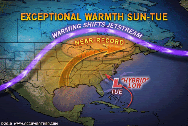
Southeast U.S. coastal storm next week could become subtropical
A region of cloudiness and showers just east of the Bahama Islands will develop into a strong extratropical storm over the weekend. This storm is expected to move slowly northwestward towards the Southeast U.S. coast Sunday and Monday, and could bring 20 - 30 mph winds and heavy rain to the coast of North Carolina by Tuesday. While the storm will initially form in a region of high wind shear and be entirely extratropical, it will move into a region of lower wind shear in a gap between the polar jet stream to the north and the subtropical jet stream to its south early next week. At that time, the low will be positioned near the warm waters of the Gulf Stream, and will have the opportunity to develop a shallow warm core and transition to a subtropical storm. The models are divided on whether the storm will eventually make landfall on the Southeast U.S. coast 6 - 7 days from now, and it is too early to offer odds on this occurring. The counter-clockwise flow of air around this low will probably lead to northeasterly winds over the oil spill region Monday through Wednesday, keeping oil away from the coasts of Alabama and the Florida Panhandle, but pushing oil westwards towards Texas.


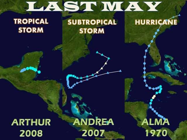
AJC3 wrote:100% wrong, my friend. I had a look at MUCH more, higher resolution data at work today compared to the coarse resolution images that you posted earlier. A phase diagram showing a forecast of at best a marginal, shallow warm core is unconvincing given the synoptic setup. The low north of Hispanola will form due to jet forced ascent, which will cause the pressure falls. Read the AFD out of Melbourne...I wrote it.

Users browsing this forum: No registered users and 41 guests


