Central Atlantic Tropical Wave (Is Invest 97L)
Moderator: S2k Moderators
Forum rules

The posts in this forum are NOT official forecasts and should not be used as such. They are just the opinion of the poster and may or may not be backed by sound meteorological data. They are NOT endorsed by any professional institution or STORM2K. For official information, please refer to products from the National Hurricane Center and National Weather Service.
-
Hurricane Mike
- Category 2

- Posts: 675
- Joined: Tue Apr 10, 2018 7:44 am
Re: Central Atlantic Tropical Wave
I don't like the ones that disappear....then pop and look good....then are gone....but suddenly blossom....then spin a bit...then go away....then spin again. The "bursting" waves, I guess you could call it. It's how many storms begin.
6 likes
-
AtlanticWind

- S2K Supporter

- Posts: 1898
- Age: 67
- Joined: Sun Aug 08, 2004 9:57 pm
- Location: Plantation,Fla
Re: Central Atlantic Tropical Wave
We should get an invest on this sometime sunday I imagine.
0 likes
-
lsuhurricane
- Category 1

- Posts: 270
- Joined: Tue Aug 15, 2017 2:53 pm
Re: Central Atlantic Tropical Wave
0z ICON brings this to hurricane strength near the eastern tip of Cuba one week from today
3 likes
-
Blown Away

- S2K Supporter
- Posts: 10253
- Joined: Wed May 26, 2004 6:17 am
Re: Central Atlantic Tropical Wave
12z Euro doesn’t see much with this wave.
Last edited by Blown Away on Sat Aug 15, 2020 11:36 pm, edited 1 time in total.
0 likes
Hurricane Eye Experience: David 79, Irene 99, Frances 04, Jeanne 04, Wilma 05… Hurricane Brush Experience: Andrew 92, Erin 95, Floyd 99, Matthew 16, Irma 17, Ian 22, Nicole 22…
Re: Central Atlantic Tropical Wave
lsuhurricane wrote:0z ICON brings this to hurricane strength near the eastern tip of Cuba one week from today
Minor correction: western tip of Cuba
Also, UKmet starting to like this wave, calling for development in W Carib by day 6, similar to ICON solution, but a bit further SW
0 likes
-
AJC3

- Admin

- Posts: 4156
- Age: 62
- Joined: Tue Aug 31, 2004 7:04 pm
- Location: Ballston Spa, New York
- Contact:
Re: Central Atlantic Tropical Wave
Tropical Weather Outlook
NWS National Hurricane Center Miami FL
200 AM EDT Sun Aug 16 2020
1. A fast-moving tropical wave located over the central tropical
Atlantic several hundred miles east of the Windward Islands is
producing a small area of disorganized showers and thunderstorms.
This system is expected to move westward at about 20 mph during the
next few days, and that fast speed is likely to limit development
while the system approaches the Windward and southern Leeward
Islands today and Monday and moves across the eastern Caribbean Sea
on Tuesday. After that time, the system is expected to move more
slowly westward across the central and western Caribbean Sea, and
upper-level winds could be conducive for development during the
middle to latter part of this week.
* Formation chance through 48 hours...low...10 percent.
* Formation chance through 5 days...low...30 percent.

1 likes
-
northjaxpro

- S2K Supporter
- Posts: 8900
- Joined: Mon Sep 27, 2010 11:21 am
- Location: Jacksonville, FL
Re: Central Atlantic Tropical Wave
Up to 30% now. We should see the Invest designation on this feature very shortly.
0 likes
NEVER, EVER SAY NEVER in the tropics and weather in general, and most importantly, with life itself!!
________________________________________________________________________________________
Fay 2008 Beryl 2012 Debby 2012 Colin 2016 Hermine 2016 Julia 2016 Matthew 2016 Irma 2017 Dorian 2019
________________________________________________________________________________________
Fay 2008 Beryl 2012 Debby 2012 Colin 2016 Hermine 2016 Julia 2016 Matthew 2016 Irma 2017 Dorian 2019

Re: Central Atlantic Tropical Wave
Solid looking LL vort far from the ITCZ and tracking into an anticyclone.
Refiring convection south of the vort.
Models get aggressive in the west Carib.
One to watch for the GoM.
Refiring convection south of the vort.
Models get aggressive in the west Carib.
One to watch for the GoM.
2 likes
-
ouragans

- Category 2
- Posts: 501
- Age: 54
- Joined: Sun Jun 12, 2011 12:09 pm
- Location: Abymes, Guadeloupe F.W.I
- Contact:
Re: Central Atlantic Tropical Wave
northjaxpro wrote:Up to 30% now. We should see the Invest designation on this feature very shortly.
Once it reaches at least 20% at 48 hrs
0 likes
Personal forecast disclaimer
This post is a personal point of view, not an information. Please refer to official statements for life-threatening decisions.
David '79, Frederic '79, Hugo '89, Iris, Luis & Marilyn '95, Georges '98, Lenny '99, Dean '07, Irma '17, Maria '17, Fiona '22, Philippe '23, Tammy '23
16°13'33.3,"6N -61°36'39.5"W
-
jaxfladude
- Category 5

- Posts: 1249
- Joined: Wed Aug 24, 2005 9:36 pm
- Location: Jacksonville, Fla
Re: Central Atlantic Tropical Wave
Is this the start of the scary times with this system?
0 likes
Stay safe y'all
-
cycloneye

- Admin
- Posts: 149715
- Age: 69
- Joined: Thu Oct 10, 2002 10:54 am
- Location: San Juan, Puerto Rico
Re: Central Atlantic Tropical Wave
A fast-moving tropical wave located about 850 miles east of the
Windward Islands is producing a small area of disorganized showers
and thunderstorms. This system is expected to move westward at
about 20 mph during the next few days, and that fast speed is likely
to limit development while the system approaches the Windward and
southern Leeward Islands today and Monday and moves across the
eastern Caribbean Sea on Tuesday. After that time, the system is
expected to move more slowly westward across the central and western
Caribbean Sea, and upper-level winds could be conducive for
development during the middle to latter part of this week.
* Formation chance through 48 hours...low...10 percent.
* Formation chance through 5 days...low...30 percent.
2 likes
Visit the Caribbean-Central America Weather Thread where you can find at first post web cams,radars
and observations from Caribbean basin members Click Here
and observations from Caribbean basin members Click Here
-
gatorcane

- S2K Supporter
- Posts: 23708
- Age: 48
- Joined: Sun Mar 13, 2005 3:54 pm
- Location: Boca Raton, FL
Re: Central Atlantic Tropical Wave
Something else that may develop but likely not before reaching the islands. May have to wait until reaching the Western Caribbean. Models support is pretty anemic still.
Favorable look in the Western Caribbean:
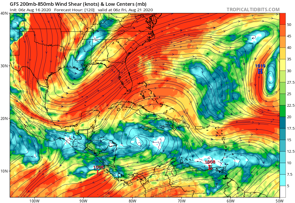
Favorable look in the Western Caribbean:
3 likes
-
toad strangler

- S2K Supporter
- Posts: 4546
- Joined: Sun Jul 28, 2013 3:09 pm
- Location: Earth
- Contact:
Re: Central Atlantic Tropical Wave
gatorcane wrote:Something else that may develop but likely not before reaching the islands. May have to wait until reaching the Western Caribbean. Models support is pretty anemic still.
Favorable look in the Western Caribbean:
https://i.postimg.cc/sDr6cCR9/gfs-shear-watl-21.png
The lemon is nearly the width of the CONUS. That right there tells me it’s not gonna develop near term.
2 likes
My Weather Station
https://www.wunderground.com/dashboard/pws/KFLPORTS603
https://www.wunderground.com/dashboard/pws/KFLPORTS603
-
Aric Dunn
- Category 5
- Posts: 21238
- Age: 43
- Joined: Sun Sep 19, 2004 9:58 pm
- Location: Ready for the Chase.
- Contact:
Re: Central Atlantic Tropical Wave
This low should begin to tap into the moisture tail of josephine later today and overnight. probably see an uptick in convection and a step closer to development.
It has begun to encircle the low with moisture from the north. cutting off the SAL.

It has begun to encircle the low with moisture from the north. cutting off the SAL.
4 likes
Note: If I make a post that is brief. Please refer back to previous posts for the analysis or reasoning. I do not re-write/qoute what my initial post said each time.
If there is nothing before... then just ask
Space & Atmospheric Physicist, Embry-Riddle Aeronautical University,
I believe the sky is falling...
If there is nothing before... then just ask
Space & Atmospheric Physicist, Embry-Riddle Aeronautical University,
I believe the sky is falling...

Re: Central Atlantic Tropical Wave
I want to say that given how dry it is Texas ( no rain in what seems like forever) how could it even survive? But with the high humidity, it really isn't dry at all. Is a low pressure system looming?
0 likes
Alicia, Rita, Ike, Harvey and Beryl...moved to Splendora lol

Re: Central Atlantic Tropical Wave
12z GFS continues with developing this TW as it gets to the Western Caribbean before reaching the Y.P.


0 likes
Re: Central Atlantic Tropical Wave
toad strangler wrote:gatorcane wrote:Something else that may develop but likely not before reaching the islands. May have to wait until reaching the Western Caribbean. Models support is pretty anemic still.
Favorable look in the Western Caribbean:
https://i.postimg.cc/sDr6cCR9/gfs-shear-watl-21.png
The lemon is nearly the width of the CONUS. That right there tells me it’s not gonna develop near term.
Doesn't this shape say more about expected fast forward motion rather than near term development odds? That's the way i always interpret it. the system is hauling. present extrapolation would imply a yucatan/western gulf threat down the road which matches nicely with climo..
4 likes
-
Aric Dunn
- Category 5
- Posts: 21238
- Age: 43
- Joined: Sun Sep 19, 2004 9:58 pm
- Location: Ready for the Chase.
- Contact:
Re: Central Atlantic Tropical Wave
With the Increasing convection and Model support, Chances are likely going to go up in the short term and long term.
vorticity is increasing convection building around the "center" ... looking good..
vorticity is increasing convection building around the "center" ... looking good..
0 likes
Note: If I make a post that is brief. Please refer back to previous posts for the analysis or reasoning. I do not re-write/qoute what my initial post said each time.
If there is nothing before... then just ask
Space & Atmospheric Physicist, Embry-Riddle Aeronautical University,
I believe the sky is falling...
If there is nothing before... then just ask
Space & Atmospheric Physicist, Embry-Riddle Aeronautical University,
I believe the sky is falling...
-
toad strangler
- S2K Supporter
- Posts: 4546
- Joined: Sun Jul 28, 2013 3:09 pm
- Location: Earth
- Contact:
Re: Central Atlantic Tropical Wave
psyclone wrote:toad strangler wrote:gatorcane wrote:Something else that may develop but likely not before reaching the islands. May have to wait until reaching the Western Caribbean. Models support is pretty anemic still.
Favorable look in the Western Caribbean:
https://i.postimg.cc/sDr6cCR9/gfs-shear-watl-21.png
The lemon is nearly the width of the CONUS. That right there tells me it’s not gonna develop near term.
Doesn't this shape say more about expected fast forward motion rather than near term development odds? That's the way i always interpret it. the system is hauling. present extrapolation would imply a yucatan/western gulf threat down the road which matches nicely with climo..
That too
1 likes
My Weather Station
https://www.wunderground.com/dashboard/pws/KFLPORTS603
https://www.wunderground.com/dashboard/pws/KFLPORTS603
-
gatorcane
- S2K Supporter
- Posts: 23708
- Age: 48
- Joined: Sun Mar 13, 2005 3:54 pm
- Location: Boca Raton, FL
Re: Central Atlantic Tropical Wave
Development certainly looks possible once it nears the Western Caribbean. That is where the wave should slow its forward speed and convection should start to “pile up” not to mention a large anticyclone should be there.
1 likes