Increased from 40% to 50%:
Tropical Weather Outlook
NWS National Hurricane Center Miami FL
200 AM EDT Mon Aug 4 2025
For the North Atlantic...Caribbean Sea and the Gulf of America:
Active Systems:
The National Hurricane Center is issuing advisories on newly formed
Tropical Storm Dexter, located over the western Atlantic Ocean.
1. Central Tropical Atlantic:
A tropical wave is forecast to move off the west coast of Africa
later today. Thereafter, some gradual development of the wave is
possible, and a tropical depression could form late this week while
it moves generally west-northwestward across the central tropical
Atlantic.
* Formation chance through 48 hours...low...near 0 percent.
* Formation chance through 7 days...medium...50 percent.
Tropical Wave in the Eastern Atlantic (Is Invest 96L)
Moderator: S2k Moderators
Forum rules

The posts in this forum are NOT official forecasts and should not be used as such. They are just the opinion of the poster and may or may not be backed by sound meteorological data. They are NOT endorsed by any professional institution or STORM2K. For official information, please refer to products from the National Hurricane Center and National Weather Service.
Re: Tropical Wave Over West Africa
0 likes
Personal Forecast Disclaimer:
The posts in this forum are NOT official forecasts and should not be used as such. They are just the opinion of the poster and may or may not be backed by sound meteorological data. They are NOT endorsed by any professional institution or storm2k.org. For official information, please refer to the NHC and NWS products.
The posts in this forum are NOT official forecasts and should not be used as such. They are just the opinion of the poster and may or may not be backed by sound meteorological data. They are NOT endorsed by any professional institution or storm2k.org. For official information, please refer to the NHC and NWS products.
Re: Tropical Wave Emerging From West Africa
Euro Ensembles still well east of the GFS, which I think will probably get more aligned with the Euro as time goes on and stay off shore. 6Z GFS put landfall in Charleston.

GFS Ensembles:

Tidbits is probably getting hit with traffic, and likely DDoSd, this year in particular I'd get familiar with some alternates
like https://pivitolweather.com https://weathermodels.com https://polarwx.com https://weathernerds.com https://cyclonicwx.com/ weatherbell and a few more (some have paywalls or partial paywalls).
To post images use something like imgur.com (2MB Limit on size) or https://postimages.org/ (or a few others) and put the image url in between two img tags. Ctrl+I on firefox shows a window with a "media" tab that lists all the images and their urls you are currently looking at (unless it uses javascript to generate them to a canvas) Another option is a snippet for a screencap Windows Key+Shift+S will bring up the snippet box on windows 10 & 11, and if you bring up snipping tool you can safe those to a file. Or just paste it into sites that allow clipboard pasting.
GFS Ensembles:
Tidbits is probably getting hit with traffic, and likely DDoSd, this year in particular I'd get familiar with some alternates
like https://pivitolweather.com https://weathermodels.com https://polarwx.com https://weathernerds.com https://cyclonicwx.com/ weatherbell and a few more (some have paywalls or partial paywalls).
To post images use something like imgur.com (2MB Limit on size) or https://postimages.org/ (or a few others) and put the image url in between two img tags. Ctrl+I on firefox shows a window with a "media" tab that lists all the images and their urls you are currently looking at (unless it uses javascript to generate them to a canvas) Another option is a snippet for a screencap Windows Key+Shift+S will bring up the snippet box on windows 10 & 11, and if you bring up snipping tool you can safe those to a file. Or just paste it into sites that allow clipboard pasting.
Last edited by BobHarlem on Mon Aug 04, 2025 6:48 am, edited 2 times in total.
2 likes
-
Blown Away

- S2K Supporter

- Posts: 10253
- Joined: Wed May 26, 2004 6:17 am
2025 Global Model Runs Discussion (Out thru day 16)
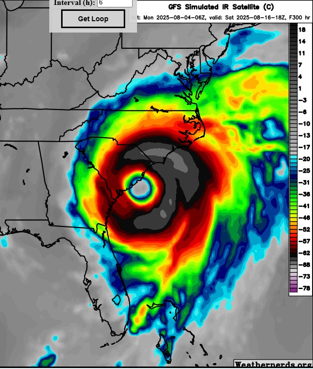
06z GFS... Still showing a very large MH impact on the SE CONUS in the long range... S.C. on this run and (2) hits on Central Florida earlier...
1 likes
Hurricane Eye Experience: David 79, Irene 99, Frances 04, Jeanne 04, Wilma 05… Hurricane Brush Experience: Andrew 92, Erin 95, Floyd 99, Matthew 16, Irma 17, Ian 22, Nicole 22…
-
cycloneye

- Admin

- Posts: 149462
- Age: 69
- Joined: Thu Oct 10, 2002 10:54 am
- Location: San Juan, Puerto Rico
Re: 2025 Global Model Runs Discussion (Out thru day 16)
Blown Away wrote:[url]https://i.postimg.cc/0jvfYkTv/06z-GFS.jpg [/url]
06z GFS... Still showing a very large MH impact on the SE CONUS in the long range... S.C. on this run and (2) hits on Central Florida earlier...
To let you know that moved your post from the models discussion thread to the African Wave thread.
2 likes
Visit the Caribbean-Central America Weather Thread where you can find at first post web cams,radars
and observations from Caribbean basin members Click Here
and observations from Caribbean basin members Click Here

Re: 2025 Global Model Runs Discussion (Out thru day 16)
Blown Away wrote:[url]https://i.postimg.cc/0jvfYkTv/06z-GFS.jpg [/url]
06z GFS... Still showing a very large MH impact on the SE CONUS in the long range... S.C. on this run and (2) hits on Central Florida earlier...
Well that escalated quickly
0 likes
Once I see the REDS and GREENS Converge on a Base Velocity. ... I'm There!!
This is NOT an Official Forecast....Just my Opinion. For official information, please refer to the NHC and NWS products.
HIGHLIGHTS : '13 El Reno Tornado : 2013 Storm Chaser Tour, Joaquin; SC flood event, Matthew '16, Lowcountry Snow storm Jan '18
This is NOT an Official Forecast....Just my Opinion. For official information, please refer to the NHC and NWS products.
HIGHLIGHTS : '13 El Reno Tornado : 2013 Storm Chaser Tour, Joaquin; SC flood event, Matthew '16, Lowcountry Snow storm Jan '18
-
cycloneye
- Admin
- Posts: 149462
- Age: 69
- Joined: Thu Oct 10, 2002 10:54 am
- Location: San Juan, Puerto Rico
Re: Tropical Wave Emerging From West Africa
8 AM cone a little more south and southwest.

1 likes
Visit the Caribbean-Central America Weather Thread where you can find at first post web cams,radars
and observations from Caribbean basin members Click Here
and observations from Caribbean basin members Click Here
-
Blown Away
- S2K Supporter
- Posts: 10253
- Joined: Wed May 26, 2004 6:17 am
Re: Tropical Wave Emerging From West Africa
NHC starting to flatten out and bend that area more W.
2 likes
Hurricane Eye Experience: David 79, Irene 99, Frances 04, Jeanne 04, Wilma 05… Hurricane Brush Experience: Andrew 92, Erin 95, Floyd 99, Matthew 16, Irma 17, Ian 22, Nicole 22…
-
TallyTracker
- Category 2

- Posts: 787
- Joined: Thu Oct 11, 2018 2:46 pm
Re: 2025 Global Model Runs Discussion (Out thru day 16)
Kohlecane wrote:Blown Away wrote:[url]https://i.postimg.cc/0jvfYkTv/06z-GFS.jpg [/url]
06z GFS... Still showing a very large MH impact on the SE CONUS in the long range... S.C. on this run and (2) hits on Central Florida earlier...
Well that escalated quickly, being here near Hilton Head all my Evacs spots would still be getting hurricane force winds lol
With an eye that large, the hurricane force winds would likely cover the entire South Carolina coast! Thankfully just a single run but disturbing nonetheless.
1 likes
Fran '96, Georges '98, Gordon '00, Gabrielle '01, Charley '04, Frances '04, Jeanne '04, Barry '07, Fay '08, Debby '12, Matthew '16, Emily '17, Irma '17, Michael ‘18, Elsa ‘21, Fred ‘21, Mindy ‘21, Nicole ‘22, Idalia ‘23, Debby ‘24, Helene ‘24
-
ScottNAtlanta

- Category 5

- Posts: 2535
- Joined: Sat May 25, 2013 3:11 pm
- Location: Atlanta, GA
Re: Tropical Wave Emerging From West Africa
Hmmm...the GFS has always had an out to sea bias in the long to medium range, so either they tweaked the model or my concern level has gone up a bit.
2 likes
The posts in this forum are NOT official forecast and should not be used as such. They are just the opinion of the poster and may or may not be backed by sound meteorological data. They are NOT endorsed by any professional institution or storm2k.org. For official information, please refer to the NHC and NWS products.
-
cycloneye
- Admin
- Posts: 149462
- Age: 69
- Joined: Thu Oct 10, 2002 10:54 am
- Location: San Juan, Puerto Rico
Re: Tropical Wave Emerging From West Africa
1 likes
Visit the Caribbean-Central America Weather Thread where you can find at first post web cams,radars
and observations from Caribbean basin members Click Here
and observations from Caribbean basin members Click Here
-
skillz305
- Category 1

- Posts: 312
- Joined: Sat Sep 08, 2018 11:10 am
- Location: Miami, Florida --> Vero Beach, Florida
Re: Tropical Wave Emerging From West Africa
That GFS run into Melbourne almost made my head spin. We can’t do another hurricane in central Florida again. Pray it curves OTS. I have my first born child coming in the next 24 hours. God bless everyone! 
3 likes
Hurricanes: Andrew 1992 - Irene 1999 - Frances 2004 - Jeanne 2004 - Katrina 2005 - Wilma 2005 - Matthew 2016 - Irma 2017 - Ian 2022 - Nicole 2022 - Milton 2024Re: Tropical Wave Emerging From West Africa
The 12z icon run shifted west a bit, but still recurves this well east of Bermuda.
0 likes
-
MEANINGLESS_NUMBERS
- Category 2
- Posts: 503
- Joined: Mon Nov 02, 2020 1:43 pm
Re: 2025 Global Model Runs Discussion (Out thru day 16)
Blown Away wrote:[url]https://i.postimg.cc/0jvfYkTv/06z-GFS.jpg [/url]
06z GFS... Still showing a very large MH impact on the SE CONUS in the long range... S.C. on this run and (2) hits on Central Florida earlier...
Safest place to be at 12 days out
2 likes
Emily '87, Felix '95, Gert '99, Fabian '03, Humberto '19, Paulette '20, Teddy '20, Fiona '22, Lee '23, Ernesto '24, Humberto/Imelda '25
Re: Tropical Wave Emerging From West Africa
12z GFS is much much weaker so far with this, and further south, it gets over the Virgin Islands in a week. I think it's given up the idea for the big storm.

Last edited by BobHarlem on Mon Aug 04, 2025 11:33 am, edited 2 times in total.
0 likes
-
ScottNAtlanta
- Category 5
- Posts: 2535
- Joined: Sat May 25, 2013 3:11 pm
- Location: Atlanta, GA
Re: Tropical Wave Emerging From West Africa
skillz305 wrote:That GFS run into Melbourne almost made my head spin. We can’t do another hurricane in central Florida again. Pray it curves OTS. I have my first born child coming in the next 24 hours. God bless everyone!
Congratulations!!! Next thing you know, they will be 18 and leaving home. It all happens so fast.
2 likes
The posts in this forum are NOT official forecast and should not be used as such. They are just the opinion of the poster and may or may not be backed by sound meteorological data. They are NOT endorsed by any professional institution or storm2k.org. For official information, please refer to the NHC and NWS products.
-
Category5Kaiju

- Category 5
- Posts: 4333
- Joined: Thu Dec 24, 2020 12:45 pm
- Location: Seattle and Phoenix
Re: Tropical Wave Emerging From West Africa
BobHarlem wrote:12z GFS is much much weaker so far with this, and further south, it gets over the Virgin Islands in a week. I think it's given up the idea for the big storm.
https://i.imgur.com/j0OLlix.png
I'd also be interested to watch the ensembles. Operational runs are quite sensitive and volatile; it's not uncommon to show a bona fide monster on one run and absolutely zilch on a subsequent run.
1 likes
Unless explicitly stated, all info in my posts is based on my own opinions and observations. Tropical storms and hurricanes can be extremely dangerous. Refer to an accredited weather research agency or meteorologist if you need to make serious decisions regarding an approaching storm.
-
WeatherBoy2000
- Category 1
- Posts: 461
- Joined: Mon Apr 10, 2023 9:29 am
Re: Tropical Wave Emerging From West Africa
BobHarlem wrote:12z GFS is much much weaker so far with this, and further south, it gets over the Virgin Islands in a week. I think it's given up the idea for the big storm.
https://i.imgur.com/j0OLlix.png
Need to see more consistent runs before this can be said definitively.
1 likes
Re: Tropical Wave Emerging From West Africa
WeatherBoy2000 wrote:BobHarlem wrote:12z GFS is much much weaker so far with this, and further south, it gets over the Virgin Islands in a week. I think it's given up the idea for the big storm.
https://i.imgur.com/j0OLlix.png
Need to see more consistent runs before this can be said definitively.
For this run for sure. But the fact this, Canadian, Icon, and Euro are all so vastly different, along with the ensembles being quite different, something else just seems off. Dexter is another example. There haven't been any consistent runs.
Last edited by BobHarlem on Mon Aug 04, 2025 11:51 am, edited 2 times in total.
0 likes
-
cycloneye
- Admin
- Posts: 149462
- Age: 69
- Joined: Thu Oct 10, 2002 10:54 am
- Location: San Juan, Puerto Rico
Re: Tropical Wave SSE of Cabo Verde Islands
Has been introduced at the 12z surface analisis.

0 likes
Visit the Caribbean-Central America Weather Thread where you can find at first post web cams,radars
and observations from Caribbean basin members Click Here
and observations from Caribbean basin members Click Here
-
WeatherBoy2000
- Category 1
- Posts: 461
- Joined: Mon Apr 10, 2023 9:29 am
Re: Tropical Wave Emerging From West Africa
BobHarlem wrote:WeatherBoy2000 wrote:BobHarlem wrote:12z GFS is much much weaker so far with this, and further south, it gets over the Virgin Islands in a week. I think it's given up the idea for the big storm.
https://i.imgur.com/j0OLlix.png
Need to see more consistent runs before this can be said definitively.
For this run for sure. But the fact this, Canadian, Icon, and Euro are all so vastly different, along with the ensembles being quite different, something else just seems off.
For better or for worse, the gfs is more prone to blowing up strong storms in the long range than compared to any of those other models.
0 likes
Who is online
Users browsing this forum: MarioProtVI and 172 guests