
SUBTROPICAL STORM ANDREA, Analysis, Sat Pics, Models Thread
Moderator: S2k Moderators
Forum rules

The posts in this forum are NOT official forecasts and should not be used as such. They are just the opinion of the poster and may or may not be backed by sound meteorological data. They are NOT endorsed by any professional institution or STORM2K. For official information, please refer to products from the National Hurricane Center and National Weather Service.
-
Stormcenter
- S2K Supporter

- Posts: 6687
- Joined: Wed Sep 03, 2003 11:27 am
- Location: Houston, TX
MortisFL wrote:Stormcenter wrote:HURAKAN wrote:What everyone has been waiting since Nov. 30, 2006. The first invest of the 2007 hurricane season.
Speak for yourself. Personally I'm looking forward to Nov. 30th 2007.
I seriously doubt that Stormcenter. You wouldn't be here otherwise.
No comment.
0 likes
Unfortunately I don't think this will help the fire situation, only aggrevate it. It gives us the NW to west winds, but little moisture. I'm in southern Brevard county, and it is a tinder box with the low DPs and winds. Hopefully it will get close enough to give us some showers. Overnight convection has dwindled, but it is trying to perk up again. Fascinating little storm system. Good thin it wasn't a month later. Unseasonably cool and dry conditions here in Melbourne right now. Cheers! 
0 likes
-
LSU2001

- S2K Supporter
- Posts: 1711
- Age: 58
- Joined: Sat Sep 11, 2004 11:01 pm
- Location: Cut Off, Louisiana
I think that we should all view this storm as a good opportunity for a warm-up/trial run for the season. I have a feeling that this season will provide alot of late nights tracking along with the associated wobble wars. To me this early storm has little chance of becoming a strong or really dangerous weather event so we should all be grateful for the chance to practice our skills before the season.
Just my 2 cent$
Tim
Just my 2 cent$
Tim
0 likes
Personal Forecast Disclaimer:
The posts in this forum are NOT official forecast and should not be used as such. They are NOT endorsed by any professional institution or storm2k.org. For official information, please refer to the NHC and NWS products.
The posts in this forum are NOT official forecast and should not be used as such. They are NOT endorsed by any professional institution or storm2k.org. For official information, please refer to the NHC and NWS products.


Steve H. wrote:Unfortunately I don't think this will help the fire situation, only aggrevate it. It gives us the NW to west winds, but little moisture. I'm in southern Brevard county, and it is a tinder box with the low DPs and winds. Hopefully it will get close enough to give us some showers. Overnight convection has dwindled, but it is trying to perk up again. Fascinating little storm system. Good thin it wasn't a month later. Unseasonably cool and dry conditions here in Melbourne right now. Cheers!
Its winds are causing havock for souther Georgia. Fires are now over 100K acres and have moved into the Okefenokee Swamp, where firefighters have to let it burn (no way to get to it there). Unless this storm can dump 5+ inches, its a nightmare scenario for firefighters....
edit-----
http://www.news4jax.com/news/13276901/detail.html
GA fires jump river, now burning in Baker County Florida
http://www.news4jax.com/news/13275181/detail.html
Bradford County Florida - 16,000 acres burning now.
Last edited by jdray on Tue May 08, 2007 11:53 am, edited 1 time in total.
0 likes
It's beginning to show up on radar -
http://radar.weather.gov/ridge/Legend/N ... gend_0.gif
*anyone else having trouble posting an image - I keep getting error - you didn't post image URL - which as you can
see I did)
guess that didn't work very well - try again -
http://radar.weather.gov/ridge/radar.ph ... 11&loop=no
http://radar.weather.gov/ridge/Legend/N ... gend_0.gif
*anyone else having trouble posting an image - I keep getting error - you didn't post image URL - which as you can
see I did)
guess that didn't work very well - try again -
http://radar.weather.gov/ridge/radar.ph ... 11&loop=no
Last edited by artist on Tue May 08, 2007 11:55 am, edited 1 time in total.
0 likes


-
Grease Monkey

- Category 2

- Posts: 727
- Joined: Fri Jun 09, 2006 9:25 pm
Just full of hot air?
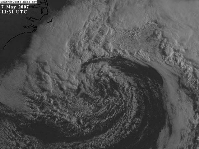
Looks like it just lacks moisture. Other than that it would look like a tropical cyclone.
Looks like it just lacks moisture. Other than that it would look like a tropical cyclone.
Last edited by Grease Monkey on Tue May 08, 2007 12:07 pm, edited 2 times in total.
0 likes
-
DESTRUCTION5

- Category 5

- Posts: 4430
- Age: 44
- Joined: Wed Sep 03, 2003 11:25 am
- Location: Stuart, FL
-
wxman57

- Moderator-Pro Met

- Posts: 23130
- Age: 68
- Joined: Sat Jun 21, 2003 8:06 pm
- Location: Houston, TX (southwest)
Still just a surface reflection of an upper-level low. The air flowing into and surrounding the low is very stable, thus the lack of deep convection and continued cold-core status. As it moves farther westward tonight it'll be moving out of the Gulf Stream and over some quite cool shelf water. Chances of any development into an STS or TS remain low. Just a bit breezy along the SE US Coast and a good chance of rain for that area tonight/Wednesday. Most of the rain will stay north of Florida, however.
0 likes
-
MississippiHurricane

- ChatStaff

- Posts: 648
- Age: 41
- Joined: Sat Jul 16, 2005 12:20 am
- Location: Hanover, Maryland
- Contact:
-
HURAKAN

- Professional-Met

- Posts: 46086
- Age: 38
- Joined: Thu May 20, 2004 4:34 pm
- Location: Key West, FL
- Contact:
TROPICAL WEATHER DISCUSSION
NWS TPC/NATIONAL HURRICANE CENTER MIAMI FL
205 PM EDT TUE MAY 08 2007
...SPECIAL FEATURE...
A NON-TROPICAL LOW PRESSURE SYSTEM...CENTERED NEAR 30.5N77W...OR
ABOUT 230 MILES EAST-SOUTHEAST OF THE GEORGIA AND SOUTH CAROLINA
COASTS...HAS BEEN MOVING SLOWLY WESTWARD AT 5 TO 10 MPH. THIS
SYSTEM IS PRODUCING GALE-FORCE WINDS AND HEAVY SURF ALONG THE
COASTS OF NORTH CAROLINA...SOUTH CAROLINA...AND GEORGIA...WITH
STRONGER WINDS OFFSHORE. THE 12Z QUIKSCAT PASS SHOWED 35-40 KT
WINDS OFF THE SOUTHEAST COAST. THESE WINDS ARE CONTINUING TO
PRODUCE A SIGNIFICANT SWELL EVENT FOR THE SOUTHEAST U.S. COAST
AND THE BAHAMAS. BUOY 41010 CONTINUES TO REPORT SEAS NEAR 20 FT.
ASSOCIATED SHOWER ACTIVITY HAS INCREASED SINCE YESTERDAY...BUT
NO SIGNIFICANT STRENGTHENING OF THIS SYSTEM IS EXPECTED. THE LOW
IS BEING MONITORED FOR SIGNS OF TROPICAL OR SUBTROPICAL CYCLONE
DEVELOPMENT...AND AN AIR FORCE RESERVE RECONNAISSANCE AIRCRAFT
WILL BE AVAILABLE TO INVESTIGATE THE SYSTEM TOMORROW
MORNING...IF NECESSARY. PLEASE REFER TO THE HIGH SEAS FORECAST
AND STATEMENTS FROM LOCAL WEATHER SERVICE OFFICES FOR MORE
DETAILS.
http://www.nhc.noaa.gov/text/refresh/MI ... 1714.shtml?
0 likes
-
Evil Jeremy

- S2K Supporter
- Posts: 5463
- Age: 32
- Joined: Mon Apr 10, 2006 2:10 pm
- Location: Los Angeles, CA
-
Hurricanehink

- S2K Supporter
- Posts: 2047
- Joined: Sun Nov 16, 2003 2:05 pm
- Location: New Jersey