Pouch P17L in Eastern Atlantic -(Now Invest 97L)

This is the general tropical discussion area. Anyone can take their shot at predicting a storms path.

Moderator: S2k Moderators

Forum rules

The posts in this forum are NOT official forecasts and should not be used as such. They are just the opinion of the poster and may or may not be backed by sound meteorological data. They are NOT endorsed by any professional institution or STORM2K. For official information, please refer to products from the National Hurricane Center and National Weather Service.

Help Support Storm2K
Message
Author
caneseddy
Category 5
Category 5
Posts: 1172
Joined: Fri Sep 03, 2004 9:31 pm
Location: Plantation, FL

Re: Pouch P17L in Eastern Atlantic

#421 Postby caneseddy » Wed Aug 17, 2011 1:41 pm

CourierPR wrote:
Ivanhater wrote:144 hours....Shredded by Hispaniola

Image

Uploaded with ImageShack.us


What's that system I see east of the Antilles on that run?


The Euro has been on that one since yesterday...JB mentioned it in his tweet yesterday saying that this system off of Africa depicted by the Euro would be the strongest system coming off of Africa since Donna in 1960 if the Euro verifies
0 likes   

User avatar
Ivanhater
Storm2k Moderator
Storm2k Moderator
Posts: 11162
Age: 38
Joined: Fri Jul 01, 2005 8:25 am
Location: Pensacola

Re: Pouch P17L in Eastern Atlantic

#422 Postby Ivanhater » Wed Aug 17, 2011 1:48 pm

192 hours...weak low in the Western Caribbean. The more important thing is the pattern. It would continue into Florida if this run developed it.

Image

Uploaded with ImageShack.us
0 likes   
Michael

Stormcenter
S2K Supporter
S2K Supporter
Posts: 6684
Joined: Wed Sep 03, 2003 11:27 am
Location: Houston, TX

#423 Postby Stormcenter » Wed Aug 17, 2011 1:51 pm

Actually I'm just playing along Portastorm. :lol:
0 likes   

caneseddy
Category 5
Category 5
Posts: 1172
Joined: Fri Sep 03, 2004 9:31 pm
Location: Plantation, FL

Re: Pouch P17L in Eastern Atlantic

#424 Postby caneseddy » Wed Aug 17, 2011 1:52 pm

12z UKMET still has it entering the Caribbean, close to GFS run

http://raleighwx.americanwx.com/models/ ... cal120.gif
0 likes   

User avatar
Ivanhater
Storm2k Moderator
Storm2k Moderator
Posts: 11162
Age: 38
Joined: Fri Jul 01, 2005 8:25 am
Location: Pensacola

Re: Pouch P17L in Eastern Atlantic

#425 Postby Ivanhater » Wed Aug 17, 2011 1:53 pm

What a pattern change.... :eek:

Image

Uploaded with ImageShack.us
0 likes   
Michael

User avatar
cycloneye
Admin
Admin
Posts: 145379
Age: 68
Joined: Thu Oct 10, 2002 10:54 am
Location: San Juan, Puerto Rico

Re: Pouch P17L in Eastern Atlantic

#426 Postby cycloneye » Wed Aug 17, 2011 1:55 pm

:uarrow: Wow Michael,look at all those H's.
0 likes   
Visit the Caribbean-Central America Weather Thread where you can find at first post web cams,radars
and observations from Caribbean basin members Click Here

jlauderdal
S2K Supporter
S2K Supporter
Posts: 7183
Joined: Wed May 19, 2004 5:46 am
Location: NE Fort Lauderdale
Contact:

Re: Re:

#427 Postby jlauderdal » Wed Aug 17, 2011 1:55 pm

Kohlecane wrote:
jlauderdal wrote:
Stormcenter wrote:I'll go out on a limb here and say that "if" this does develop it's not a central GOM event. JMHO


i say the "center" passes at least 150 miles to the S of Fort Lauderdale


Based On what madel, i live in LADY DALE :eek:

based on the ridge overhead, there has to be a center though, system might not develop or it gets killed off over hispanola
0 likes   

User avatar
wxman57
Moderator-Pro Met
Moderator-Pro Met
Posts: 22980
Age: 67
Joined: Sat Jun 21, 2003 8:06 pm
Location: Houston, TX (southwest)

Re: Pouch P17L in Eastern Atlantic

#428 Postby wxman57 » Wed Aug 17, 2011 1:55 pm

European doesn't indicate much development, but it does break down the ridge over TX by day 10 and build the ridge north of the Caribbean westward over Florida. That could open up the central Gulf coast for a possible impact.
0 likes   

User avatar
Kohlecane
Category 2
Category 2
Posts: 593
Age: 33
Joined: Sun Jul 31, 2011 11:03 pm
Location: Beaufort, SC

Re: Pouch P17L in Eastern Atlantic

#429 Postby Kohlecane » Wed Aug 17, 2011 1:56 pm

CourierPR wrote:
Ivanhater wrote:144 hours....Shredded by Hispaniola

http://img811.imageshack.us/img811/2360/12zeurotropical850mbvorn.gif

Uploaded with ImageShack.us


What's that system I see east of the Antilles on that run?


Ha i just spotted that Holy Hell
0 likes   
Once I see the REDS and GREENS Converge on a Base Velocity. ... I'm There!!

This is NOT an Official Forecast....Just my Opinion. For official information, please refer to the NHC and NWS products.
HIGHLIGHTS : '13 El Reno Tornado : 2013 Storm Chaser Tour, Joaquin; SC flood event, Matthew '16, Lowcountry Snow storm Jan '18

User avatar
Ivanhater
Storm2k Moderator
Storm2k Moderator
Posts: 11162
Age: 38
Joined: Fri Jul 01, 2005 8:25 am
Location: Pensacola

Re: Pouch P17L in Eastern Atlantic

#430 Postby Ivanhater » Wed Aug 17, 2011 1:59 pm

The pattern advertised on the Euro is very worrisome for the central Gulf coast
0 likes   
Michael

weatherguy2
Tropical Depression
Tropical Depression
Posts: 72
Joined: Sun Aug 01, 2010 2:45 am

Re: Pouch P17L in Eastern Atlantic

#431 Postby weatherguy2 » Wed Aug 17, 2011 1:59 pm

FWIW look at the new 12z FIMY model:

Image
0 likes   

BigB0882
S2K Supporter
S2K Supporter
Posts: 2284
Joined: Thu Jul 03, 2003 12:08 am
Location: Baton Rouge, LA
Contact:

#432 Postby BigB0882 » Wed Aug 17, 2011 2:01 pm

That latest run opens up Louisiana BIG TIME. Not liking that, at all. :eek:
0 likes   

Stormcenter
S2K Supporter
S2K Supporter
Posts: 6684
Joined: Wed Sep 03, 2003 11:27 am
Location: Houston, TX

#433 Postby Stormcenter » Wed Aug 17, 2011 2:09 pm

Should we all just evacuate the entire GOM coastline now?

I'm just kidding of course but patterns do change folks so I wouldn't
get so worked up just yet. IMO

Haven't the models been predicting this eventual "pattern change"
throughout this Summer. I'm just saying.
Last edited by Stormcenter on Wed Aug 17, 2011 2:12 pm, edited 1 time in total.
0 likes   

Kory
Tropical Storm
Tropical Storm
Posts: 200
Age: 29
Joined: Tue Aug 02, 2011 11:32 am
Location: New Orleans, Louisiana

Re:

#434 Postby Kory » Wed Aug 17, 2011 2:09 pm

BigB0882 wrote:That latest run opens up Louisiana BIG TIME. Not liking that, at all. :eek:

Yep, very ominous pattern shown by the Euro. I have split thoughts on this future pattern set up. The pattern has been dominant protecting the western and central Gulf coast for months now, but the pattern eventually will break and give Texas a respite. Just gotta watch and see....

The posts in this forum are NOT official forecast and should not be used as such. They are just the opinion of the poster and may or may not be backed by sound meteorological data. They are NOT endorsed by any professional institution or storm2k.org. For official information, please refer to the NHC and NWS products.
0 likes   

User avatar
micktooth
S2K Supporter
S2K Supporter
Posts: 391
Joined: Mon Jul 11, 2005 3:47 pm
Location: PreK:New Orleans,PostK:Colorado

Re: Pouch P17L in Eastern Atlantic

#435 Postby micktooth » Wed Aug 17, 2011 2:09 pm

OK Guys, all of these model "monsters", so when is this going to develop? If it will indeed "bomb", when do you all think the process will start?
0 likes   

BigB0882
S2K Supporter
S2K Supporter
Posts: 2284
Joined: Thu Jul 03, 2003 12:08 am
Location: Baton Rouge, LA
Contact:

Re:

#436 Postby BigB0882 » Wed Aug 17, 2011 2:12 pm

Stormcenter wrote:Should we all just evacuate the entire GOM coastline now?

I'm just kidding of course but patterns do change folks so I wouldn't
get so worked up just yet. IMO


No one is worried or worked up. We are just enjoying our hobby which is model watching. You seem to post the same thing over and over. I'm not sure you would think anything was worth posting until the gale force winds are on your front porch.
0 likes   

User avatar
northjaxpro
S2K Supporter
S2K Supporter
Posts: 8900
Joined: Mon Sep 27, 2010 11:21 am
Location: Jacksonville, FL

#437 Postby northjaxpro » Wed Aug 17, 2011 2:13 pm

So, it appears the ECMWF runs 10 days out are finally breaking down the long persistant death ridge over Texas. Well, I tell you that ridge has been parked over the Southern Plains and Texas it seems like forever. You have to figure at some point that ridge will finally loosen its grip eventually.

If the Euro pans out right with regards of weakening that death ridge, then the Gulf Coast could get in the mix IF this system develops during the coming days. We have a long time to watch this. Also, let's see how the other dynamical model runs handle the death ridge as time progresses.
Last edited by northjaxpro on Wed Aug 17, 2011 2:21 pm, edited 1 time in total.
0 likes   
NEVER, EVER SAY NEVER in the tropics and weather in general, and most importantly, with life itself!!

________________________________________________________________________________________

Fay 2008 Beryl 2012 Debby 2012 Colin 2016 Hermine 2016 Julia 2016 Matthew 2016 Irma 2017 Dorian 2019

Aric Dunn
Category 5
Category 5
Posts: 21238
Age: 42
Joined: Sun Sep 19, 2004 9:58 pm
Location: Ready for the Chase.
Contact:

Re: Pouch P17L in Eastern Atlantic

#438 Postby Aric Dunn » Wed Aug 17, 2011 2:16 pm

Ivanhater wrote:192 hours...weak low in the Western Caribbean. The more important thing is the pattern. It would continue into Florida if this run developed it.

Image

Uploaded with ImageShack.us


exactly. the pattern has not changed and continues the consistency
0 likes   
Note: If I make a post that is brief. Please refer back to previous posts for the analysis or reasoning. I do not re-write/qoute what my initial post said each time.
If there is nothing before... then just ask :)

Space & Atmospheric Physicist, Embry-Riddle Aeronautical University,
I believe the sky is falling...

User avatar
SoupBone
Category 5
Category 5
Posts: 3111
Joined: Tue Sep 20, 2005 5:24 pm

Re:

#439 Postby SoupBone » Wed Aug 17, 2011 2:20 pm

Stormcenter wrote:Should we all just evacuate the entire GOM coastline now?

I'm just kidding of course but patterns do change folks so I wouldn't
get so worked up just yet. IMO

Haven't the models been predicting this eventual "pattern change"
throughout this Summer. I'm just saying
.


Yes, which is why I keep asking what has changed that would force a stubborn and dominanat high from texas/Louisiana. :)
0 likes   

User avatar
HurricaneMaster_PR
Category 2
Category 2
Posts: 795
Joined: Tue Jul 22, 2003 6:23 pm
Location: San Juan, Puerto Rico

Re: Pouch P17L in Eastern Atlantic

#440 Postby HurricaneMaster_PR » Wed Aug 17, 2011 2:21 pm

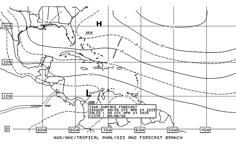
TAFB 72 hrs Surface Forecast
Image
0 likes   


Return to “Talkin' Tropics”

Who is online

Users browsing this forum: cajungal, cycloneye, dl20415, IsabelaWeather, jaguars_22, kenayers, kevin and 55 guests