ENSO Updates (2007 thru 2023)

This is the general tropical discussion area. Anyone can take their shot at predicting a storms path.

Moderator: S2k Moderators

Forum rules

The posts in this forum are NOT official forecasts and should not be used as such. They are just the opinion of the poster and may or may not be backed by sound meteorological data. They are NOT endorsed by any professional institution or STORM2K. For official information, please refer to products from the National Hurricane Center and National Weather Service.

Help Support Storm2K
Message
Author
User avatar
cycloneye
Admin
Admin
Posts: 145383
Age: 68
Joined: Thu Oct 10, 2002 10:54 am
Location: San Juan, Puerto Rico

Re: ENSO Updates

#4301 Postby cycloneye » Wed Apr 30, 2014 7:36 pm

Can you believe the 30 day SOI is about to cross to La Nina threshold of +8?

http://www.bom.gov.au/climate/enso/soi.txt

Image
0 likes   
Visit the Caribbean-Central America Weather Thread where you can find at first post web cams,radars
and observations from Caribbean basin members Click Here

User avatar
Hammy
Category 5
Category 5
Posts: 5849
Age: 42
Joined: Fri May 25, 2012 5:25 pm
Contact:

#4302 Postby Hammy » Wed Apr 30, 2014 7:38 pm

Is this in any way related to the shrinking of the subsurface warm pool?
0 likes   
The above post is not official and should not be used as such. It is the opinion of the poster and may or may not be backed by sound meteorological data. It is not endorsed by any professional institution or storm2k.org. For official information, please refer to the NHC and NWS products.

User avatar
Ntxw
Storm2k Moderator
Storm2k Moderator
Posts: 22786
Joined: Wed Oct 21, 2009 6:34 pm
Location: DFW, Texas

Re: ENSO Updates

#4303 Postby Ntxw » Wed Apr 30, 2014 7:44 pm

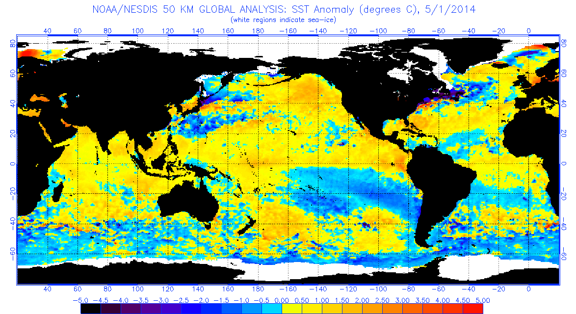
cycloneye wrote:It appears bigtime upwelling is going on at Nino 3.4 and 4.


You have to be careful with these daily's the TAO buoys is showing expanding of 0.5C not reducing. As a reminder the CDAS maps do not always follow the TAO/Triton data for whatever reason. I have very little doubt the El Nino is making it's appearance right now, as remains the question is how strong will it be and when the CPC will declare it.

Last update- this was 0.4C
Image

Latest 5 day average, we are well on our way to the first greater than 0.5C reading on Monday
Image

Currents are moving strongly from west to east, it's only due time we will see another strong down-well oceanic kelvin wave and possibly another strong warm pool for the fall.

Image
Last edited by Ntxw on Wed Apr 30, 2014 7:55 pm, edited 3 times in total.
0 likes   
The above post and any post by Ntxw is NOT an official forecast and should not be used as such. It is just the opinion of the poster and may or may not be backed by sound meteorological data. It is NOT endorsed by any professional institution including Storm2k. For official information, please refer to NWS products.

  Help support Storm2K!
Help Support Storm2K

User avatar
cycloneye
Admin
Admin
Posts: 145383
Age: 68
Joined: Thu Oct 10, 2002 10:54 am
Location: San Juan, Puerto Rico

Re: ENSO Updates

#4304 Postby cycloneye » Wed Apr 30, 2014 7:49 pm

JB keeps insisting on El Nino being Modoki.

"‏@BigJoeBastardi · I outlined in Sept 2011 series of 3 potentially harsh winters.12-13,13-14,14-15 . Modiki winters like we have next winter usually cold,snowy."
0 likes   
Visit the Caribbean-Central America Weather Thread where you can find at first post web cams,radars
and observations from Caribbean basin members Click Here

User avatar
Ntxw
Storm2k Moderator
Storm2k Moderator
Posts: 22786
Joined: Wed Oct 21, 2009 6:34 pm
Location: DFW, Texas

Re: ENSO Updates

#4305 Postby Ntxw » Wed Apr 30, 2014 7:52 pm

cycloneye wrote:JB keeps insisting on El Nino being Modoki.

"‏@BigJoeBastardi · I outlined in Sept 2011 series of 3 potentially harsh winters.12-13,13-14,14-15 . Modiki winters like we have next winter usually cold,snowy."


His modoki is 2009 style, where it was a full basin El Nino with strongest warm anomalies in the cpac. He's been harping 02 and 09. He seems to be favoring this because of his call for cold US winter.
0 likes   
The above post and any post by Ntxw is NOT an official forecast and should not be used as such. It is just the opinion of the poster and may or may not be backed by sound meteorological data. It is NOT endorsed by any professional institution including Storm2k. For official information, please refer to NWS products.


  Help support Storm2K!

Help Support Storm2K


User avatar
Kingarabian
S2K Supporter
S2K Supporter
Posts: 15981
Joined: Sat Aug 08, 2009 3:06 am
Location: Honolulu, Hawaii

Re:

#4306 Postby Kingarabian » Wed Apr 30, 2014 9:42 pm

Hammy wrote:Is this in any way related to the shrinking of the subsurface warm pool?

Tropical activity near Darwin.

One has to think that if the atmosphere continues to not correlate with the ocean, a strong Nino may be out of the pictures.
0 likes   
RIP Kobe Bryant

dexterlabio
Category 5
Category 5
Posts: 3468
Joined: Sat Oct 24, 2009 11:50 pm

Re: ENSO Updates

#4307 Postby dexterlabio » Wed Apr 30, 2014 10:19 pm

cycloneye wrote:JB keeps insisting on El Nino being Modoki.

"‏@BigJoeBastardi · I outlined in Sept 2011 series of 3 potentially harsh winters.12-13,13-14,14-15 . Modiki winters like we have next winter usually cold,snowy."


I still don't get how he can still harp for a modoki when things are going like this.

Image


Whether it's strong or moderate, the potential EN this year looks more like a traditional, east-based one.

Having said that, I think we will get an El Nino reading in MJJ. Not sure if it will make to EN threshold in AMJ period. The atmosphere has to correlate with the ocean first for a steady warming...but I believe we are getting there..
0 likes   
Personal Forecast Disclaimer:
The posts in this forum are NOT official forecast and should not be used as such. They are just the opinion of the poster and may or may not be backed by sound meteorological data. They are NOT endorsed by any professional institution or storm2k.org. For official information, please refer to the NHC and NWS products.

User avatar
xtyphooncyclonex
Category 5
Category 5
Posts: 3861
Age: 23
Joined: Sat Dec 08, 2012 9:07 am
Location: Cebu City
Contact:

#4308 Postby xtyphooncyclonex » Wed Apr 30, 2014 10:38 pm

Is there a model that forecasts a Modoki? ECMWF did before, but they changed to an EP type El Niño.
0 likes   
REMINDER: My opinions that I, or any other NON Pro-Met in this forum, are unofficial. Please do not take my opinions as an official forecast and warning. I am NOT a meteorologist. Following my forecasts blindly may lead to false alarm, danger and risk if official forecasts from agencies are ignored.

User avatar
xtyphooncyclonex
Category 5
Category 5
Posts: 3861
Age: 23
Joined: Sat Dec 08, 2012 9:07 am
Location: Cebu City
Contact:

Re: ENSO Updates

#4309 Postby xtyphooncyclonex » Wed Apr 30, 2014 10:40 pm

cycloneye wrote:Can you believe the 30 day SOI is about to cross to La Nina threshold of +8?

http://www.bom.gov.au/climate/enso/soi.txt

Image

Other Niño years had these blips too. Let's wait till it goes down significantly.
0 likes   
REMINDER: My opinions that I, or any other NON Pro-Met in this forum, are unofficial. Please do not take my opinions as an official forecast and warning. I am NOT a meteorologist. Following my forecasts blindly may lead to false alarm, danger and risk if official forecasts from agencies are ignored.

User avatar
xtyphooncyclonex
Category 5
Category 5
Posts: 3861
Age: 23
Joined: Sat Dec 08, 2012 9:07 am
Location: Cebu City
Contact:

#4310 Postby xtyphooncyclonex » Wed Apr 30, 2014 10:46 pm

CFSv2 has an uptick in El Niño intensity. From borderline 1.5 to 1.7 in Niño 3.4 amd an uptick in other Niño regions too.
0 likes   
REMINDER: My opinions that I, or any other NON Pro-Met in this forum, are unofficial. Please do not take my opinions as an official forecast and warning. I am NOT a meteorologist. Following my forecasts blindly may lead to false alarm, danger and risk if official forecasts from agencies are ignored.

User avatar
xtyphooncyclonex
Category 5
Category 5
Posts: 3861
Age: 23
Joined: Sat Dec 08, 2012 9:07 am
Location: Cebu City
Contact:

Re: ENSO Updates

#4311 Postby xtyphooncyclonex » Thu May 01, 2014 8:40 am

Big-time warming seen near the coast of Peru and the rest of Niño 1+2. Warming is also spreading westwards and is also evident near Niño 3 too. Warm pool south of the warm waters now weakening giving way to warmer anomalies. Slight warming also seen over the Niño regions 3.4 and 4.
Image
0 likes   
REMINDER: My opinions that I, or any other NON Pro-Met in this forum, are unofficial. Please do not take my opinions as an official forecast and warning. I am NOT a meteorologist. Following my forecasts blindly may lead to false alarm, danger and risk if official forecasts from agencies are ignored.

User avatar
xtyphooncyclonex
Category 5
Category 5
Posts: 3861
Age: 23
Joined: Sat Dec 08, 2012 9:07 am
Location: Cebu City
Contact:

#4312 Postby xtyphooncyclonex » Thu May 01, 2014 8:56 am

Obviously an Eastern Pacific (EP) type El Niño as seen in the graphic above. Niño 1+2 is the warmest region as of now. Not surprised if anomalies there will reach moderate threshold anytime in this or next week.
Last edited by xtyphooncyclonex on Thu May 01, 2014 8:56 pm, edited 1 time in total.
0 likes   
REMINDER: My opinions that I, or any other NON Pro-Met in this forum, are unofficial. Please do not take my opinions as an official forecast and warning. I am NOT a meteorologist. Following my forecasts blindly may lead to false alarm, danger and risk if official forecasts from agencies are ignored.

User avatar
xtyphooncyclonex
Category 5
Category 5
Posts: 3861
Age: 23
Joined: Sat Dec 08, 2012 9:07 am
Location: Cebu City
Contact:

#4313 Postby xtyphooncyclonex » Thu May 01, 2014 9:13 am

In the TAO data, it is showing 2 different subsurface pools, one is the CP weakening pool and the very warm pool near Peru. The other data shows the subsurface pool has weakened. Which is real now?
0 likes   
REMINDER: My opinions that I, or any other NON Pro-Met in this forum, are unofficial. Please do not take my opinions as an official forecast and warning. I am NOT a meteorologist. Following my forecasts blindly may lead to false alarm, danger and risk if official forecasts from agencies are ignored.

User avatar
cycloneye
Admin
Admin
Posts: 145383
Age: 68
Joined: Thu Oct 10, 2002 10:54 am
Location: San Juan, Puerto Rico

Re: ENSO Updates

#4314 Postby cycloneye » Thu May 01, 2014 9:37 am

CFSv2 peaks around +1.7C by OND period.One ensemble member goes to the roof with a super,super,super El Nino above +3.0C but I think is a big outlier. :)

Image
0 likes   
Visit the Caribbean-Central America Weather Thread where you can find at first post web cams,radars
and observations from Caribbean basin members Click Here

User avatar
xtyphooncyclonex
Category 5
Category 5
Posts: 3861
Age: 23
Joined: Sat Dec 08, 2012 9:07 am
Location: Cebu City
Contact:

Re: ENSO Updates

#4315 Postby xtyphooncyclonex » Thu May 01, 2014 9:44 am

cycloneye wrote:CFSv2 peaks around +1.7C by OND period.One ensemble member goes to the roof with a super,super,super El Nino above +3.0C but I think is a big outlier. :)

Image

All ensemble members go above 0.5 C for this year.and isn't 1.7 strong?
0 likes   
REMINDER: My opinions that I, or any other NON Pro-Met in this forum, are unofficial. Please do not take my opinions as an official forecast and warning. I am NOT a meteorologist. Following my forecasts blindly may lead to false alarm, danger and risk if official forecasts from agencies are ignored.

User avatar
xtyphooncyclonex
Category 5
Category 5
Posts: 3861
Age: 23
Joined: Sat Dec 08, 2012 9:07 am
Location: Cebu City
Contact:

Re: ENSO Updates

#4316 Postby xtyphooncyclonex » Thu May 01, 2014 10:15 am

Finally, the Philippine media notice the upcoming El Niño. It says "An El Niño is possible to occur by June or July".
Image
0 likes   
REMINDER: My opinions that I, or any other NON Pro-Met in this forum, are unofficial. Please do not take my opinions as an official forecast and warning. I am NOT a meteorologist. Following my forecasts blindly may lead to false alarm, danger and risk if official forecasts from agencies are ignored.

User avatar
Ntxw
Storm2k Moderator
Storm2k Moderator
Posts: 22786
Joined: Wed Oct 21, 2009 6:34 pm
Location: DFW, Texas

#4317 Postby Ntxw » Thu May 01, 2014 10:19 am

A little link I thought I'd share. I know we talk about sub-surface, anomalies, and ocean water but many don't understand what it means hence the talk of growing and shrinking warm pools.

http://www.classzone.com/books/earth_science/terc/content/investigations/esu601/esu601page02.cfm?chapter_no=investigation

To understand ENSO one must know how the thermocline works, so fun link of the day!

There is really (sort of) no such thing as a warm pool in the sub-surface coming and going in thin air (or ocean). It's simply the movement of Ocean water, a warm anomaly is when the warm ocean water from the west is evenly distributed from east to west, cooler anomalies is the retreat of this warm water. So it's not appearing and disappearing, it's moving.

Hope it is a good read!
Last edited by Ntxw on Thu May 01, 2014 10:20 am, edited 1 time in total.
0 likes   
The above post and any post by Ntxw is NOT an official forecast and should not be used as such. It is just the opinion of the poster and may or may not be backed by sound meteorological data. It is NOT endorsed by any professional institution including Storm2k. For official information, please refer to NWS products.


  Help support Storm2K!

Help Support Storm2K


asd123
Category 1
Category 1
Posts: 265
Joined: Tue Sep 06, 2011 7:06 pm
Location: Orlando, Florida

Re:

#4318 Postby asd123 » Thu May 01, 2014 10:19 am

xtyphooncyclonex wrote:In the TAO data, it is showing 2 different subsurface pools, one is the CP weakening pool and the very warm pool near Peru. The other data shows the subsurface pool has weakened. Which is real now?


Make sure you check the date;

Go to viewtopic.php?f=31&t=92137&start=0

The 5th image down shows the current anomaly pool as of May 1 (This image updates daily). If you go down to the 7th image, that image is from April 21 (Image updates, don't know how often, at least weekly, if not longer). As of the most recent image, the pool has actually strengthened.
0 likes   
This post is NOT AN OFFICIAL FORECAST and should not be used as such. It is just the opinion of the poster and may or may not be backed by sound meteorological data. It is NOT endorsed by any professional institution including storm2k.org. For Official Information please refer to the NHC and NWS products.

User avatar
Ntxw
Storm2k Moderator
Storm2k Moderator
Posts: 22786
Joined: Wed Oct 21, 2009 6:34 pm
Location: DFW, Texas

#4319 Postby Ntxw » Thu May 01, 2014 10:56 am

So assuming we've all looked at the link :wink:, here's the latest Satellite data of sea surface heights(updates every 15 days so new one soon).

Image
______
Here was 2009 at it's peak, modoki. Sea level never rose all that much in the east, mostly central pacific as was 2002 and 2004.

Image
0 likes   
The above post and any post by Ntxw is NOT an official forecast and should not be used as such. It is just the opinion of the poster and may or may not be backed by sound meteorological data. It is NOT endorsed by any professional institution including Storm2k. For official information, please refer to NWS products.


  Help support Storm2K!

Help Support Storm2K


User avatar
Ntxw
Storm2k Moderator
Storm2k Moderator
Posts: 22786
Joined: Wed Oct 21, 2009 6:34 pm
Location: DFW, Texas

#4320 Postby Ntxw » Thu May 01, 2014 11:22 am

So now that you've been teased with what a modoki looks like, you ask what did the last big traditional El Nino look like, in terms of sea leve heights? (minus 2006 it was too weak and saw little height rises) and you get 1997!

April 25, 1997

Image

By the end of May it looks like this

Image

Lets see where we stand in about 3 weeks, we are definitely heading in that direction in the eastern Pacific.
Last edited by Ntxw on Thu May 01, 2014 11:24 am, edited 1 time in total.
0 likes   
The above post and any post by Ntxw is NOT an official forecast and should not be used as such. It is just the opinion of the poster and may or may not be backed by sound meteorological data. It is NOT endorsed by any professional institution including Storm2k. For official information, please refer to NWS products.


  Help support Storm2K!

Help Support Storm2K


Return to “Talkin' Tropics”

Who is online

Users browsing this forum: Cpv17, Frank P, jaguars_22, TomballEd, USTropics and 64 guests