
Atlantic Sea Surface Temperatures and Anomalies
Moderator: S2k Moderators
Forum rules

The posts in this forum are NOT official forecasts and should not be used as such. They are just the opinion of the poster and may or may not be backed by sound meteorological data. They are NOT endorsed by any professional institution or STORM2K. For official information, please refer to products from the National Hurricane Center and National Weather Service.
-
cycloneye

- Admin

- Posts: 149479
- Age: 69
- Joined: Thu Oct 10, 2002 10:54 am
- Location: San Juan, Puerto Rico
Re: Atlantic Sea Surface Temperatures and Anomalies
My goodness!, no change from a month ago in terms of the very warm anomalies in the MDR and North Atlantic.
0 likes
Visit the Caribbean-Central America Weather Thread where you can find at first post web cams,radars
and observations from Caribbean basin members Click Here
and observations from Caribbean basin members Click Here
-
wxman57

- Moderator-Pro Met

- Posts: 23174
- Age: 68
- Joined: Sat Jun 21, 2003 8:06 pm
- Location: Houston, TX (southwest)
Re: Atlantic Sea Surface Temperatures and Anomalies
Blown Away wrote:ROCK wrote:yeah Luis...those anomalies do look ominous of they hold into spring....with what I suspect nuetral ENSO this could mean another big year....
If the pattern remains we may have another active season with a weak Bermuda High and majority of the systems staying offshore??
Current long-range Euro is predicting higher pressures across the Caribbean April-June. That would signal a stronger Bermuda High in 2011 than it was in 2010. This increases the landfall threat farther west (Caribbean/U.S.). The chart below is from Dec. 15th. January's forecast will be out around this weekend.

0 likes
-
Ivanhater

- Storm2k Moderator

- Posts: 11221
- Age: 39
- Joined: Fri Jul 01, 2005 8:25 am
- Location: Pensacola
Re: Atlantic Sea Surface Temperatures and Anomalies
What is concerning to me Wxman on the map you posted is the lower pressure developing over the central U.S. I am probably getting ahead of myself this early but that could signal an opening in the Gulf, instead of plowing west into Mexico. Extremely early at this stage, but I would imagine that would spell trouble for the SE Coast and U.S Gulf coast.
0 likes
Michael
-
cycloneye
- Admin
- Posts: 149479
- Age: 69
- Joined: Thu Oct 10, 2002 10:54 am
- Location: San Juan, Puerto Rico
Re: Atlantic Sea Surface Temperatures and Anomalies
The MDR area continues very warm thanks to the continuation of the negative NAO.

0 likes
Visit the Caribbean-Central America Weather Thread where you can find at first post web cams,radars
and observations from Caribbean basin members Click Here
and observations from Caribbean basin members Click Here
-
cycloneye
- Admin
- Posts: 149479
- Age: 69
- Joined: Thu Oct 10, 2002 10:54 am
- Location: San Juan, Puerto Rico
Re: Atlantic Sea Surface Temperatures and Anomalies
It continues to be well above normal on the anomalies front in the MDR.

0 likes
Visit the Caribbean-Central America Weather Thread where you can find at first post web cams,radars
and observations from Caribbean basin members Click Here
and observations from Caribbean basin members Click Here
-
cycloneye
- Admin
- Posts: 149479
- Age: 69
- Joined: Thu Oct 10, 2002 10:54 am
- Location: San Juan, Puerto Rico
Re: Atlantic Sea Surface Temperatures and Anomalies
It continues to be warm in the Tropical Atlantic,but not as warm it was in early January.
January 8
Uploaded by imageshack.us
Febuary 19

Uploaded by imageshack.us
January 8
Uploaded by imageshack.us
Febuary 19
Uploaded by imageshack.us
0 likes
Visit the Caribbean-Central America Weather Thread where you can find at first post web cams,radars
and observations from Caribbean basin members Click Here
and observations from Caribbean basin members Click Here
-
cycloneye
- Admin
- Posts: 149479
- Age: 69
- Joined: Thu Oct 10, 2002 10:54 am
- Location: San Juan, Puerto Rico
Re: Atlantic Sea Surface Temperatures and Anomalies
As of March 17,the sst's in the North Atlantic basin in general are cooler than in 2010. But there is a warm finger in the GOM this year,that 2010 didn't have on this date.
March 17,2010

March 17,2011

March 17,2010
March 17,2011
0 likes
Visit the Caribbean-Central America Weather Thread where you can find at first post web cams,radars
and observations from Caribbean basin members Click Here
and observations from Caribbean basin members Click Here


Re: Atlantic Sea Surface Temperatures and Anomalies
The Loop current is warmer now than March 2010, it won't be good if it stays warmer than normal by the time of the hurricane season unless wind shear is high enough to prevent development.
0 likes
-
StormClouds63
- Category 2

- Posts: 583
- Age: 62
- Joined: Tue May 13, 2008 11:56 am
- Location: Southwest Louisiana
Re: Atlantic Sea Surface Temperatures and Anomalies
As another poster commented, one of the keys to the 2011 season will be the position and strength of the Bermuda High. Water temps are important, but steering patterns and upper level conditions will largely determine whether it's a high or low impact year for U.S. landfalls. All of us along the GOM were very fortunate that a busy season turned uot to be a quiet one as well. Memories of Rita and Ike are still fresh in the public's mind, so no apathy here.
0 likes
Re: Atlantic Sea Surface Temperatures and Anomalies
Although SSTs are not as high overall basin-wide as this time last year, in general, most areas of the basin south of 20N are running near normal to above normal in SST. The Gulf and area off the S.E. coast of the U.S. will warm quickly once cold fronts grind to a halt and no longer drive cold air down from the north.
Lower SST than last year in the eastern atlantic may not be a good thing - if systems don't develop as quickly off of the coast of africa - and slighly cooler sst can be a contributing factor to less development right off the bat, systems may make it further west before they develop instead of rapidly-developed systems turning into fish storms.....just a thought....look at where storms formed in 2005....they made it pretty far west before forming (Katrina and Rita didn't become depressions until they were in the bahamas).

Lower SST than last year in the eastern atlantic may not be a good thing - if systems don't develop as quickly off of the coast of africa - and slighly cooler sst can be a contributing factor to less development right off the bat, systems may make it further west before they develop instead of rapidly-developed systems turning into fish storms.....just a thought....look at where storms formed in 2005....they made it pretty far west before forming (Katrina and Rita didn't become depressions until they were in the bahamas).
0 likes
-
Ivanhater
- Storm2k Moderator
- Posts: 11221
- Age: 39
- Joined: Fri Jul 01, 2005 8:25 am
- Location: Pensacola
Re: Atlantic Sea Surface Temperatures and Anomalies
Gulf really heating up. Loop current has checked in for Hurricane season.
0 likes
Michael
-
cycloneye
- Admin
- Posts: 149479
- Age: 69
- Joined: Thu Oct 10, 2002 10:54 am
- Location: San Juan, Puerto Rico
Re: Atlantic Sea Surface Temperatures and Anomalies
jinftl wrote:Although SSTs are not as high overall basin-wide as this time last year, in general, most areas of the basin south of 20N are running near normal to above normal in SST. The Gulf and area off the S.E. coast of the U.S. will warm quickly once cold fronts grind to a halt and no longer drive cold air down from the north.
Lower SST than last year in the eastern atlantic may not be a good thing - if systems don't develop as quickly off of the coast of africa - and slighly cooler sst can be a contributing factor to less development right off the bat, systems may make it further west before they develop instead of rapidly-developed systems turning into fish storms.....just a thought....look at where storms formed in 2005....they made it pretty far west before forming (Katrina and Rita didn't become depressions until they were in the bahamas).
A rebound in the sst anomalies on this week's update in the MDR,parts of GOM and in the extreme North Atlantic.

0 likes
Visit the Caribbean-Central America Weather Thread where you can find at first post web cams,radars
and observations from Caribbean basin members Click Here
and observations from Caribbean basin members Click Here
-
Weatherfreak000
Re:
Weatherfreak000 wrote:^^^
I agree....SST's rebounding in a big way. And with the EURO showing La Nina-Neutral it could still be a nasty season. But like I was saying earlier this month the models shifting towards El Nino is a prohibitive factor.
It depends on the strenght of El Niño too and it may also depend if it is Modoki or Normal, a weak El Niño could still be very bad like 1969 or 2004.
0 likes
-
cycloneye
- Admin
- Posts: 149479
- Age: 69
- Joined: Thu Oct 10, 2002 10:54 am
- Location: San Juan, Puerto Rico
Re: Atlantic Sea Surface Temperatures and Anomalies
The updated image of the Atlantic anomalies shows even a more warmer basin in general,even in the GOM.

Uploaded by imageshack.us
Uploaded by imageshack.us
0 likes
Visit the Caribbean-Central America Weather Thread where you can find at first post web cams,radars
and observations from Caribbean basin members Click Here
and observations from Caribbean basin members Click Here
-
wxman57
- Moderator-Pro Met
- Posts: 23174
- Age: 68
- Joined: Sat Jun 21, 2003 8:06 pm
- Location: Houston, TX (southwest)
Re: Atlantic Sea Surface Temperatures and Anomalies
Remember, those are anomalies, not temperatures. Northern Gulf temps are still rather cool from Texas to Florida.

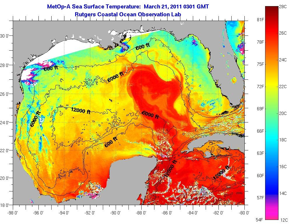
However, SSTs across the Gulf for THIS year are a good bit warmer than for the same time last March:

However, SSTs across the Gulf for THIS year are a good bit warmer than for the same time last March:
0 likes


Re: Atlantic Sea Surface Temperatures and Anomalies
Yep, if I remember correctly last year it was a rather cool & rainy late winter & early spring across the gulf coast & most of FL thus for why waters in the northern GOM were much cooler compared to this time of the year so far.
Interesting how much farther north the Loop Current in the GOM is this year compared to at least last year.
Interesting how much farther north the Loop Current in the GOM is this year compared to at least last year.
0 likes
-
wxman57
- Moderator-Pro Met
- Posts: 23174
- Age: 68
- Joined: Sat Jun 21, 2003 8:06 pm
- Location: Houston, TX (southwest)
Re: Atlantic Sea Surface Temperatures and Anomalies
NDG wrote:Yep, if I remember correctly last year it was a rather cool & rainy late winter & early spring across the gulf coast & most of FL thus for why waters in the northern GOM were much cooler compared to this time of the year so far.
Interesting how much farther north the Loop Current in the GOM is this year compared to at least last year.
That could be related to stronger easterly trades across the Caribbean and Tropical Atlantic due to a stronger Bermuda High this year. That would also be responsible for the reduced SSTs in the MDR this year over last year. They're still quite warm, but not as warm as 2010.
0 likes

Re: Atlantic Sea Surface Temperatures and Anomalies
wxman57 wrote:Remember, those are anomalies, not temperatures. Northern Gulf temps are still rather cool from Texas to Florida.
However, SSTs across the Gulf for THIS year are a good bit warmer than for the same time last March:
the contrast is even a bit more as the scale this year is 0.5 higher than last year...meaning if it were on the same scale the color contrast would be greater...interesting
0 likes
Who is online
Users browsing this forum: No registered users and 208 guests