2025 Global Model Runs Discussion (Out thru day 16)
Moderator: S2k Moderators
Forum rules

The posts in this forum are NOT official forecasts and should not be used as such. They are just the opinion of the poster and may or may not be backed by sound meteorological data. They are NOT endorsed by any professional institution or STORM2K. For official information, please refer to products from the National Hurricane Center and National Weather Service.
-
Tailgater33
- Tropical Depression

- Posts: 94
- Joined: Thu Jun 02, 2022 9:15 am
Re: 2025 Global Model Runs Discussion (Out thru day 16)
Quite a little flare up NE Puerto Rico, shrimp look to it and all. Northern end of a wave. I haven’t been watching much but I don’t see it mentioned so I guess it’ll be puffed in the morning.
1 likes

Re: 2025 Global Model Runs Discussion (Out thru day 16)
You wake up and look at the satellites to see this and the models are like nope nothing, hmm.

6 likes
Re: 2025 Global Model Runs Discussion (Out thru day 16)
ChrisH-UK wrote:You wake up and look at the satellites to see this and the models are like nope nothing, hmm.
[url]https://imagizer.imageshack.com/img923/6362/afVFde.gif [/url]
Has some vorticity also. (leftovers from 94L)

1 likes
-
Blown Away

- S2K Supporter

- Posts: 10253
- Joined: Wed May 26, 2004 6:17 am
Re: 2025 Global Model Runs Discussion (Out thru day 16)
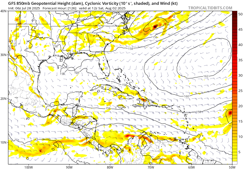
06z GFS... Now showing a weak signal with this area moving through NE Caribbean and fizzles out in the SE Bahamas...
0 likes
Hurricane Eye Experience: David 79, Irene 99, Frances 04, Jeanne 04, Wilma 05… Hurricane Brush Experience: Andrew 92, Erin 95, Floyd 99, Matthew 16, Irma 17, Ian 22, Nicole 22…
-
Blown Away
- S2K Supporter
- Posts: 10253
- Joined: Wed May 26, 2004 6:17 am
Re: 2025 Global Model Runs Discussion (Out thru day 16)
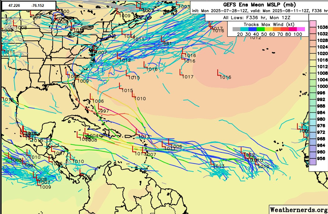
12z GEFS... Definite uptick and intensity for a few members...
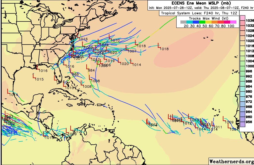
12z ECENS... Backing off on development...
1 likes
Hurricane Eye Experience: David 79, Irene 99, Frances 04, Jeanne 04, Wilma 05… Hurricane Brush Experience: Andrew 92, Erin 95, Floyd 99, Matthew 16, Irma 17, Ian 22, Nicole 22…
-
Stratton23
- Category 5

- Posts: 3558
- Joined: Fri Jul 21, 2023 10:59 pm
- Location: Katy, Tx
Re: 2025 Global Model Runs Discussion (Out thru day 16)
Still cant write this wave off yet, Euro AIFS is sticking with its guns, still some support on the GEFS, it aint over till its over
0 likes
Re: 2025 Global Model Runs Discussion (Out thru day 16)
beyond the Canadian/EuroAI wave is the regular euro with this

3 likes
-
Stratton23
- Category 5
- Posts: 3558
- Joined: Fri Jul 21, 2023 10:59 pm
- Location: Katy, Tx
Re: 2025 Global Model Runs Discussion (Out thru day 16)
00z ICON shows development of the wave ( that the Euro AI was showing development on )
0 likes
-
Stratton23
- Category 5
- Posts: 3558
- Joined: Fri Jul 21, 2023 10:59 pm
- Location: Katy, Tx
Re: 2025 Global Model Runs Discussion (Out thru day 16)
CMC 00z On board with development, strong TS off shore of eastern US
0 likes
Re: 2025 Global Model Runs Discussion (Out thru day 16)
Standard operational 0z Euro is looking a lot closer to the AI now, fwiw. Although it doesn't really develop the system until it gets into the Gulf. Once there it's more bullish than the AI (979mb hurricane approaching LA there) And other wave following up east of it. AI this time is a little stronger east of Florida, but doesn't develop in the Gulf nearly as much. GFS hints at it too, but it takes the energy mostly over the Caribbean islands which keeps the thing weak. I have to wonder if the GFS shifted north of the islands if anything would change on it.

Ensembles like the system off the Carolinas -- operationals not so much. Ensembles aren't too keen on the MDR thing, however.
Ensembles like the system off the Carolinas -- operationals not so much. Ensembles aren't too keen on the MDR thing, however.
5 likes

Re: 2025 Global Model Runs Discussion (Out thru day 16)
06z Euro AI continues it's development of our wave with low crossing S FL and a tropical storm riding up the west coast of Florida. 00z Operational Euro on board with low developing into a 979 mb hurricane in the GOM. Still way out in the long range but models starting the perk up as we enter August.
4 likes
-
DorkyMcDorkface

- Category 5
- Posts: 1012
- Age: 28
- Joined: Mon Sep 30, 2019 1:32 pm
- Location: Mid-Atlantic
Re: 2025 Global Model Runs Discussion (Out thru day 16)
BobHarlem wrote:Standard operational 0z Euro is looking a lot closer to the AI now, fwiw. Although it doesn't really develop the system until it gets into the Gulf. Once there it's more bullish than the AI (979mb hurricane approaching LA there) And other wave following up east of it. AI this time is a little stronger east of Florida, but doesn't develop in the Gulf nearly as much. GFS hints at it too, but it takes the energy mostly over the Caribbean islands which keeps the thing weak. I have to wonder if the GFS shifted north of the islands if anything would change on it.
https://i.postimg.cc/cJ3hk6cS/ecmwf-z850-vort-watl-fh135-360.gif
Ensembles like the system off the Carolinas -- operationals not so much. Ensembles aren't too keen on the MDR thing, however.
There's a third one in the MDR at the tail end of the run. Subject to change at this juncture obviously but this might be the model picking up on increased favorability as the MJO moves out of the Pacific and into our region of the world.

5 likes
Please note the thoughts expressed by this account are solely those of the user and are from a hobbyist perspective. For more comprehensive analysis, consult an actual professional meteorologist or meteorological agency.
Floyd 1999 | Isabel 2003 | Hanna 2008 | Irene 2011 | Sandy 2012 | Isaias 2020
-
Stratton23
- Category 5
- Posts: 3558
- Joined: Fri Jul 21, 2023 10:59 pm
- Location: Katy, Tx
Re: 2025 Global Model Runs Discussion (Out thru day 16)
CMC develops a weak system that crosses florida and into the NE gulf
1 likes
Re: 2025 Global Model Runs Discussion (Out thru day 16)
0Z UKMET fwiw has TCG/a TD at 168 in the far NW Bahamas:
NEW TROPICAL CYCLONE FORECAST TO DEVELOP AFTER 168 HOURS
FORECAST POSITION AT T+168 : 26.9N 78.3W
LEAD CENTRAL MAXIMUM WIND
VERIFYING TIME TIME POSITION PRESSURE (MB) SPEED (KNOTS)
-------------- ---- -------- ------------- -------------
0000UTC 06.08.2025 168 26.9N 78.3W 1014 27
NEW TROPICAL CYCLONE FORECAST TO DEVELOP AFTER 168 HOURS
FORECAST POSITION AT T+168 : 26.9N 78.3W
LEAD CENTRAL MAXIMUM WIND
VERIFYING TIME TIME POSITION PRESSURE (MB) SPEED (KNOTS)
-------------- ---- -------- ------------- -------------
0000UTC 06.08.2025 168 26.9N 78.3W 1014 27
1 likes
Personal Forecast Disclaimer:
The posts in this forum are NOT official forecasts and should not be used as such. They are just the opinion of the poster and may or may not be backed by sound meteorological data. They are NOT endorsed by any professional institution or storm2k.org. For official information, please refer to the NHC and NWS products.
The posts in this forum are NOT official forecasts and should not be used as such. They are just the opinion of the poster and may or may not be backed by sound meteorological data. They are NOT endorsed by any professional institution or storm2k.org. For official information, please refer to the NHC and NWS products.
-
StormWeather

- Category 1

- Posts: 476
- Joined: Wed Jun 05, 2024 2:34 pm
Re: 2025 Global Model Runs Discussion (Out thru day 16)
Anyone notice that the 00Z GFS run today wanted Iona’s remnants to survive all the way to the Philippines?
0 likes
Just an average cyclone tracker
The posts in this forum are NOT official forecasts and should not be used as such. They are just the opinion of the poster and may or may not be backed by sound meteorological data. They are NOT endorsed by any professional institution or storm2k.org. For official information, please refer to the NHC and NWS products
The posts in this forum are NOT official forecasts and should not be used as such. They are just the opinion of the poster and may or may not be backed by sound meteorological data. They are NOT endorsed by any professional institution or storm2k.org. For official information, please refer to the NHC and NWS products
Re: 2025 Global Model Runs Discussion (Out thru day 16)
This video is Bill Read and more talking with Mark Andersson one of the main folks behind the new Google Deep Mind model (NTWC)
https://www.youtube.com/watch?v=UPXebRV_KPE
https://www.youtube.com/watch?v=UPXebRV_KPE
1 likes
Re: 2025 Global Model Runs Discussion (Out thru day 16)
The UKMET is back to having a TD form on the 0Z. But unlike yesterday’s 0Z, which developed the current central MDR wave that was moving NNW to threaten the SE US, this one forms on an old front just off the SE US coast. After forming, it crawls NNE to just offshore the Mid-Atlantic coast remaining as a TD:
NEW TROPICAL CYCLONE FORECAST TO DEVELOP AFTER 90 HOURS
FORECAST POSITION AT T+ 90 : 32.0N 75.3W
LEAD CENTRAL MAXIMUM WIND
VERIFYING TIME TIME POSITION PRESSURE (MB) SPEED (KNOTS)
-------------- ---- -------- ------------- -------------
0000UTC 04.08.2025 96 31.4N 75.7W 1010 29
1200UTC 04.08.2025 108 32.1N 74.8W 1012 25
0000UTC 05.08.2025 120 32.1N 75.0W 1013 25
1200UTC 05.08.2025 132 33.1N 73.9W 1015 23
0000UTC 06.08.2025 144 34.3N 73.9W 1015 23
1200UTC 06.08.2025 156 35.7N 73.6W 1014 30
0000UTC 07.08.2025 168 37.6N 73.0W 1012 28
——————-
*Edit: 0Z Euro is a bit similar to 0Z UKMET but with just a very weak sfc low rather than a TD. It similarly goes up the US E coast just offshore and then toward Cape Cod and Maine.
2 likes
Personal Forecast Disclaimer:
The posts in this forum are NOT official forecasts and should not be used as such. They are just the opinion of the poster and may or may not be backed by sound meteorological data. They are NOT endorsed by any professional institution or storm2k.org. For official information, please refer to the NHC and NWS products.
The posts in this forum are NOT official forecasts and should not be used as such. They are just the opinion of the poster and may or may not be backed by sound meteorological data. They are NOT endorsed by any professional institution or storm2k.org. For official information, please refer to the NHC and NWS products.
-
TomballEd
- Category 5
- Posts: 1292
- Age: 62
- Joined: Wed Aug 16, 2023 4:52 pm
- Location: Spring/Klein area, not Tomball
Re: 2025 Global Model Runs Discussion (Out thru day 16)
LarryWx wrote:The UKMET is back to having a TD form on the 0Z. But unlike yesterday’s 0Z, which developed the current central MDR wave that was moving NNW to threaten the SE US, this one forms on an old front just off the SE US coast. After forming, it crawls NNE to just offshore the Mid-Atlantic coast remaining as a TD:
NEW TROPICAL CYCLONE FORECAST TO DEVELOP AFTER 90 HOURS
FORECAST POSITION AT T+ 90 : 32.0N 75.3W
LEAD CENTRAL MAXIMUM WIND
VERIFYING TIME TIME POSITION PRESSURE (MB) SPEED (KNOTS)
-------------- ---- -------- ------------- -------------
0000UTC 04.08.2025 96 31.4N 75.7W 1010 29
1200UTC 04.08.2025 108 32.1N 74.8W 1012 25
0000UTC 05.08.2025 120 32.1N 75.0W 1013 25
1200UTC 05.08.2025 132 33.1N 73.9W 1015 23
0000UTC 06.08.2025 144 34.3N 73.9W 1015 23
1200UTC 06.08.2025 156 35.7N 73.6W 1014 30
0000UTC 07.08.2025 168 37.6N 73.0W 1012 28
——————-
*Edit: 0Z Euro is a bit similar to 0Z UKMET but with just a very weak sfc low rather than a TD. It similarly goes up the US E coast just offshore and the toward Cape Cod and Maine.
There is some support from the ensembles. The ensembles have quieted down quite a bit in the last couple of days but GFS/Euro both have members developing something off the SEUSA. I think any named storm the next two weeks will be of non-tropical origin. The last few days inside 16 days might favor systems waiting until they are N of the Caribbean to develop per Euro weekly strike probs. Just beyond the 16 day scope of the thread the area which has 5% odds of a named system increase somewhat and max probs increase. Still mainly N of the Caribbean and off the East Coast.
Below just outside the 16 days when Euro weeklies start looking interesting. But the week before is similar, just smaller and lower max probs.

1 likes
-
cycloneye

- Admin

- Posts: 149462
- Age: 69
- Joined: Thu Oct 10, 2002 10:54 am
- Location: San Juan, Puerto Rico
Re: 2025 Global Model Runs Discussion (Out thru day 16)
Ensembles perking up as the real peak approaches.
https://x.com/AdrianLinares28/status/1950907828496978158
https://x.com/AdrianLinares28/status/1950907828496978158
2 likes
Visit the Caribbean-Central America Weather Thread where you can find at first post web cams,radars
and observations from Caribbean basin members Click Here
and observations from Caribbean basin members Click Here
Re: 2025 Global Model Runs Discussion (Out thru day 16)
For the 2nd run in a row, the UKMET (12Z) has a TD from off the SE US from a frontal zone with no further strengthening of note and with very slow movement. This run has it initially moving NE/NNE before turning to the WSW and then SW a couple hundred miles off NC:
NEW TROPICAL CYCLONE FORECAST TO DEVELOP AFTER 66 HOURS
FORECAST POSITION AT T+ 66 : 32.9N 73.5W
LEAD CENTRAL MAXIMUM WIND
VERIFYING TIME TIME POSITION PRESSURE (MB) SPEED (KNOTS)
-------------- ---- -------- ------------- -------------
1200UTC 03.08.2025 72 32.7N 72.9W 1010 26
0000UTC 04.08.2025 84 33.1N 71.9W 1009 26
1200UTC 04.08.2025 96 33.9N 70.8W 1010 29
0000UTC 05.08.2025 108 34.3N 70.4W 1012 27
1200UTC 05.08.2025 120 35.1N 69.4W 1014 30
0000UTC 06.08.2025 132 35.8N 69.2W 1014 31
1200UTC 06.08.2025 144 36.4N 69.1W 1015 30
0000UTC 07.08.2025 156 36.0N 69.8W 1015 31
1200UTC 07.08.2025 168 35.5N 70.4W 1016 29
Last edited by LarryWx on Thu Jul 31, 2025 12:27 pm, edited 1 time in total.
0 likes
Personal Forecast Disclaimer:
The posts in this forum are NOT official forecasts and should not be used as such. They are just the opinion of the poster and may or may not be backed by sound meteorological data. They are NOT endorsed by any professional institution or storm2k.org. For official information, please refer to the NHC and NWS products.
The posts in this forum are NOT official forecasts and should not be used as such. They are just the opinion of the poster and may or may not be backed by sound meteorological data. They are NOT endorsed by any professional institution or storm2k.org. For official information, please refer to the NHC and NWS products.
Who is online
Users browsing this forum: Yellow Evan and 51 guests