ENSO Updates (2007 thru 2023)
Moderator: S2k Moderators
Forum rules

The posts in this forum are NOT official forecasts and should not be used as such. They are just the opinion of the poster and may or may not be backed by sound meteorological data. They are NOT endorsed by any professional institution or STORM2K. For official information, please refer to products from the National Hurricane Center and National Weather Service.
-
xtyphooncyclonex

- Category 5

- Posts: 3891
- Age: 24
- Joined: Sat Dec 08, 2012 9:07 am
- Location: Cebu City
- Contact:
I wonder if the next WWB, which may arrive over the WPAC later this month, will bring us a massive warming again.
0 likes
REMINDER: My opinions that I, or any other NON Pro-Met in this forum, are unofficial. Please do not take my opinions as an official forecast and warning. I am NOT a meteorologist. Following my forecasts blindly may lead to false alarm, danger and risk if official forecasts from agencies are ignored.


Re: ENSO Updates
Update will be tomorrow and everything looks to hold course. We didn't see much cooling overall this week and the buoys said more warming (but they have been acting up so can't trust them). Last week was 0.6 lets see if we hold steady or slightly warmed.


0 likes
The above post and any post by Ntxw is NOT an official forecast and should not be used as such. It is just the opinion of the poster and may or may not be backed by sound meteorological data. It is NOT endorsed by any professional institution including Storm2k. For official information, please refer to NWS products.
Help support Storm2K!
-
cycloneye

- Admin

- Posts: 149454
- Age: 69
- Joined: Thu Oct 10, 2002 10:54 am
- Location: San Juan, Puerto Rico
Re: ENSO Updates
We will have this week the update of the May PDO data so let's see how much it went up from the +1.13 that was in April.
0 likes
Visit the Caribbean-Central America Weather Thread where you can find at first post web cams,radars
and observations from Caribbean basin members Click Here
and observations from Caribbean basin members Click Here
-
CaliforniaResident
- Tropical Storm

- Posts: 215
- Joined: Fri Feb 21, 2014 1:47 pm
Re:
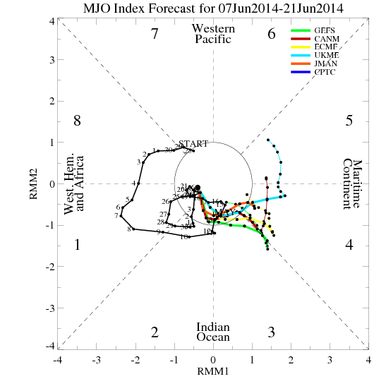
NDG wrote:The last few days the Euro (which did the best last year forecasting the MJO) has been trending towards the MJO really weakening as it heads into the western Pacific.
Is this MJO our last chance of a hope for a strong El Nino to set in this fall? If this doesn't materialize, is it "game over"?
0 likes
-
xtyphooncyclonex
- Category 5
- Posts: 3891
- Age: 24
- Joined: Sat Dec 08, 2012 9:07 am
- Location: Cebu City
- Contact:
Current CPC SST data for June 4, 2014
1+2: +1.4ºC
3: +0.8ºC
3.4: +0.5ºC
4: +0.8ºC
Niño 3 warmed a bit, while the rest of the Niño regions have cooled.
Compared to last week
1+2: +1.6ºC
3: +0.8ºC
3.4: +0.6ºC
4: +0.9ºC
1+2: +1.4ºC
3: +0.8ºC
3.4: +0.5ºC
4: +0.8ºC
Niño 3 warmed a bit, while the rest of the Niño regions have cooled.
Compared to last week
1+2: +1.6ºC
3: +0.8ºC
3.4: +0.6ºC
4: +0.9ºC
0 likes
REMINDER: My opinions that I, or any other NON Pro-Met in this forum, are unofficial. Please do not take my opinions as an official forecast and warning. I am NOT a meteorologist. Following my forecasts blindly may lead to false alarm, danger and risk if official forecasts from agencies are ignored.
-
cycloneye
- Admin
- Posts: 149454
- Age: 69
- Joined: Thu Oct 10, 2002 10:54 am
- Location: San Juan, Puerto Rico
Re: ENSO Updates
Daily SOI going down in negative. The beginning of a definite crash to negative?
SOI values for 09 Jun 2014
Average for last 30 days
8.9
Average for last 90 days
1.2
Daily contribution to SOI calculation
-29.0
SOI values for 09 Jun 2014
Average for last 30 days
8.9
Average for last 90 days
1.2
Daily contribution to SOI calculation
-29.0
0 likes
Visit the Caribbean-Central America Weather Thread where you can find at first post web cams,radars
and observations from Caribbean basin members Click Here
and observations from Caribbean basin members Click Here
-
xtyphooncyclonex
- Category 5
- Posts: 3891
- Age: 24
- Joined: Sat Dec 08, 2012 9:07 am
- Location: Cebu City
- Contact:
Looks like we have to wait for a warming over the next weeks for an El Niño to be declared this month. And it will, as a WWB brought by the MJO could bring some warming later this month.
SOI now is tanking and should continue, brought by the very negative daily value.
http://www.longpaddock.qld.gov.au/seaso ... tionindex/
Looks like an El Niño really is coming.
SOI now is tanking and should continue, brought by the very negative daily value.
http://www.longpaddock.qld.gov.au/seaso ... tionindex/
Looks like an El Niño really is coming.
0 likes
REMINDER: My opinions that I, or any other NON Pro-Met in this forum, are unofficial. Please do not take my opinions as an official forecast and warning. I am NOT a meteorologist. Following my forecasts blindly may lead to false alarm, danger and risk if official forecasts from agencies are ignored.
-
xtyphooncyclonex
- Category 5
- Posts: 3891
- Age: 24
- Joined: Sat Dec 08, 2012 9:07 am
- Location: Cebu City
- Contact:
Re: ENSO Updates
The graphic which I thought was glitched and not yet updated is finally fixed and has already been updated. So we have a wide swath of warm waters spreading over Niño 3 merging with the warm pool over the equatorial portion of the IDL. There are also several patches of +2ºC anomalies over Niño regions 1+2 & 3. Maybe we could see warmer departures in the update next week.

0 likes
REMINDER: My opinions that I, or any other NON Pro-Met in this forum, are unofficial. Please do not take my opinions as an official forecast and warning. I am NOT a meteorologist. Following my forecasts blindly may lead to false alarm, danger and risk if official forecasts from agencies are ignored.
Re: ENSO Updates
Like I said a few days ago, Nino 3.4 was going to cool down, at least temporarily.
0 likes
Re: ENSO Updates
The weekly enso anomalies index shows Nino 3.4 down a little to 0.5C. 1+2 down to 1.4C, 3 up to 0.8C, and 4 down a little to 0.8C. Should be official in a few hours in the update. Overall no big changes this update everything either moved up or down by one or two tenths.
0 likes
The above post and any post by Ntxw is NOT an official forecast and should not be used as such. It is just the opinion of the poster and may or may not be backed by sound meteorological data. It is NOT endorsed by any professional institution including Storm2k. For official information, please refer to NWS products.
Help support Storm2K!
Help support Storm2K!

Re:
NDG wrote:CFSv2 is still persistent of Nino 1+2 cooling down below El Nino threshold by SON period. What you guys have to say about it, I have not seen anybody else bring this up again ever since I brought this up a few weeks ago.
http://i20.photobucket.com/albums/b245/ ... 629548.gif
If that's the case and becomes reality, Joe Bastardi will get his 2009 late modoki esque Nino for his cold winter prediction as that Nino did about the same in that ENSO basin for the same period. Not that I agree with him but hey there's the data as you posted.
0 likes
The above post and any post by Ntxw is NOT an official forecast and should not be used as such. It is just the opinion of the poster and may or may not be backed by sound meteorological data. It is NOT endorsed by any professional institution including Storm2k. For official information, please refer to NWS products.
Help support Storm2K!
Help support Storm2K!
Re: Re:
Ntxw wrote:NDG wrote:CFSv2 is still persistent of Nino 1+2 cooling down below El Nino threshold by SON period. What you guys have to say about it, I have not seen anybody else bring this up again ever since I brought this up a few weeks ago.
http://i20.photobucket.com/albums/b245/ ... 629548.gif
If that's the case and becomes reality, Joe Bastardi will get his 2009 late modoki esque Nino for his cold winter prediction as that Nino did about the same in that ENSO basin for the same period. Not that I agree with him but hey there's the data as you posted.
Thanks for your reply, correct me if I'm wrong but if Modoki does become a reality that would mean that the SW US could remain drier than average, for the most part?
0 likes
-
xtyphooncyclonex
- Category 5
- Posts: 3891
- Age: 24
- Joined: Sat Dec 08, 2012 9:07 am
- Location: Cebu City
- Contact:
Niño 1+2 would go down, but it is more likely that it will go down SLOWER and less sharply than what CFSv2 was expecting. This is what happened during the early part of the 1982 and most of the 1991 events. But this year would still be classified as a traditional El Niño.
0 likes
REMINDER: My opinions that I, or any other NON Pro-Met in this forum, are unofficial. Please do not take my opinions as an official forecast and warning. I am NOT a meteorologist. Following my forecasts blindly may lead to false alarm, danger and risk if official forecasts from agencies are ignored.
Re: Re:
NDG wrote:Ntxw wrote:NDG wrote:CFSv2 is still persistent of Nino 1+2 cooling down below El Nino threshold by SON period. What you guys have to say about it, I have not seen anybody else bring this up again ever since I brought this up a few weeks ago.
http://i20.photobucket.com/albums/b245/ ... 629548.gif
If that's the case and becomes reality, Joe Bastardi will get his 2009 late modoki esque Nino for his cold winter prediction as that Nino did about the same in that ENSO basin for the same period. Not that I agree with him but hey there's the data as you posted.
Thanks for your reply, correct me if I'm wrong but if Modoki does become a reality that would mean that the SW US could remain drier than average, for the most part?
It could, it also depends on the strength. Virtually all Nino's feature more precip in the southern half from Cal to Florida. Modoki's precipitation favors the southern tier of the country east of the Rockies for the highest, an EP more to the desert southwest.
0 likes
The above post and any post by Ntxw is NOT an official forecast and should not be used as such. It is just the opinion of the poster and may or may not be backed by sound meteorological data. It is NOT endorsed by any professional institution including Storm2k. For official information, please refer to NWS products.
Help support Storm2K!
Help support Storm2K!
-
xtyphooncyclonex
- Category 5
- Posts: 3891
- Age: 24
- Joined: Sat Dec 08, 2012 9:07 am
- Location: Cebu City
- Contact:
Re: Re:
CaliforniaResident wrote:NDG wrote:The last few days the Euro (which did the best last year forecasting the MJO) has been trending towards the MJO really weakening as it heads into the western Pacific.
Is this MJO our last chance of a hope for a strong El Nino to set in this fall? If this doesn't materialize, is it "game over"?
A strong event is likely for this year. But I guess you meant a "super" El Niño? A super Niño chance would be like 25% IMO compared to 75% also IMO. SSTs may reach the "super" threshold for a few times but it is the ONI which is the basis, meaning the 3-month average of Niño 3.4 departures is also the basis to deter the intensity of the El Niño.
The warm pool over the subsurface, beneath the equator, which was supposed to rapidly weaken, actually is still very persistent, and could even get stronger because of a possible MJO which will bring a WWB which would enhance the warming, specially over the subsurface.
--------------------
The posts in this forum are NOT official forecast and should not be used as such. They are just the opinion of the poster and may or may not be backed by sound meteorological data. They are NOT endorsed by any professional institution or storm2k.org. For official information, please refer to the CPC/NOAA and BOM products.
0 likes
REMINDER: My opinions that I, or any other NON Pro-Met in this forum, are unofficial. Please do not take my opinions as an official forecast and warning. I am NOT a meteorologist. Following my forecasts blindly may lead to false alarm, danger and risk if official forecasts from agencies are ignored.
-
euro6208
Re:
NDG wrote:CFSv2 is still persistent of Nino 1+2 cooling down below El Nino threshold by SON period. What you guys have to say about it, I have not seen anybody else bring this up again ever since I brought this up a few weeks ago.
If that were to happen then this el nino would be a total bust even if weaker...
0 likes
-
xtyphooncyclonex
- Category 5
- Posts: 3891
- Age: 24
- Joined: Sat Dec 08, 2012 9:07 am
- Location: Cebu City
- Contact:
Re: Re:
euro6208 wrote:NDG wrote:CFSv2 is still persistent of Nino 1+2 cooling down below El Nino threshold by SON period. What you guys have to say about it, I have not seen anybody else bring this up again ever since I brought this up a few weeks ago.
TOTAL BUST!
Total Bust? It's not like the El Niño is going to be cancelled, in fact, the CFSv2 is expecting this to be a moderate-to-strong El Niño for the main Niño region 3.4 and please NOTE the difficulty of how to forecast a very complicated thing like this. Please also remember that this is only a prediction and a forecast, and it is not an absolute guarantee of what will actually happen. Please don't also overexaggerate. So far, CFSv2 is the only model I know that is forecasting a modoki-esque El Niño. A Modoki El Niño is a bust? Very meaningless. Don't also forget that one of the strongest in history was a Modoki type, the 1965-1966 event.
DO NOT FORGET THAT NIÑO 3.4 IS THE BASIS OF DETERMINING THE INTENSITY OF THE EL NIÑO AND NOT 1+2. AND THAT CFSv2 AND THE ECMWF ARE EXPECTING A MODERATE TO STRONG EVENT.
0 likes
REMINDER: My opinions that I, or any other NON Pro-Met in this forum, are unofficial. Please do not take my opinions as an official forecast and warning. I am NOT a meteorologist. Following my forecasts blindly may lead to false alarm, danger and risk if official forecasts from agencies are ignored.
-
cycloneye
- Admin
- Posts: 149454
- Age: 69
- Joined: Thu Oct 10, 2002 10:54 am
- Location: San Juan, Puerto Rico
Re: ENSO Updates
Climate Prediction Center 6/9/14 update
Nino 3.4 went down slightly from +0.6C last week to +0.5C in this weekly update.
http://www.cpc.ncep.noaa.gov/products/a ... ts-web.pdf
Nino 3.4 went down slightly from +0.6C last week to +0.5C in this weekly update.
http://www.cpc.ncep.noaa.gov/products/a ... ts-web.pdf
0 likes
Visit the Caribbean-Central America Weather Thread where you can find at first post web cams,radars
and observations from Caribbean basin members Click Here
and observations from Caribbean basin members Click Here
Who is online
Users browsing this forum: No registered users and 168 guests