Seasonal Indicators (Beyond Day 16): Instability / SST's / MSLP / Steering / Sal
Moderator: S2k Moderators
Forum rules

The posts in this forum are NOT official forecasts and should not be used as such. They are just the opinion of the poster and may or may not be backed by sound meteorological data. They are NOT endorsed by any professional institution or STORM2K. For official information, please refer to products from the National Hurricane Center and National Weather Service.


Re: 2016 indicators: Instability / SST's / MSLP / Steering / Sal
One thing we have to think about. In the mid latitudes, warmer than normal SST's often is a sign of stronger ridging. Weaker Azores high years (thus sometimes bigger season) are amongst years with the Atlantic tripole. Cooler waters up there is often indicative of lower pressures. It's not as simple as warmer than normal SST's means more activity. The past two seasons much above SST's anoms have coincided with the stronger Bermuda ridge thus reflecting the higher than normal pressures. It is always warm enough to sustain tropical activity during peak season regardless of SST anoms. But the anoms can give hints to upper air patterns.
0 likes
The above post and any post by Ntxw is NOT an official forecast and should not be used as such. It is just the opinion of the poster and may or may not be backed by sound meteorological data. It is NOT endorsed by any professional institution including Storm2k. For official information, please refer to NWS products.
Help support Storm2K!
-
tarheelprogrammer

- S2K Supporter

- Posts: 1793
- Joined: Mon Mar 28, 2016 9:25 pm
- Location: Raleigh, NC area (Garner, NC)
Re: 2016 indicators: Instability / SST's / MSLP / Steering / Sal
Ntxw wrote:One thing we have to think about. In the mid latitudes, warmer than normal SST's often is a sign of stronger ridging. Weaker Azores high years (thus sometimes bigger season) are amongst years with the Atlantic tripole. Cooler waters up there is often indicative of lower pressures. It's not as simple as warmer than normal SST's means more activity. The past two seasons much above SST's anoms have coincided with the stronger Bermuda ridge thus reflecting the higher than normal pressures. It is always warm enough to sustain tropical activity during peak season regardless of SST anoms. But the anoms can give hints to upper air patterns.
Thanks for the input and that really broke down if SSTs are important or not in terms of the hurricane season activity.
0 likes
My posts are not official forecasts. They are just my opinion and may or may not be backed by sound meteorological data. They are NOT endorsed by any professional institution or storm2k.org. For official information, please refer to the NHC and NWS products.
-
TheStormExpert
Re: 2016 indicators: Instability / SST's / MSLP / Steering / Sal
We might have a weaker than normal Azores High but what's the strength of the Bermuda High? That will be key in determining if we see storms recurving out to sea or coming close and or affecting land.
0 likes
Re: 2016 indicators: Instability / SST's / MSLP / Steering / Sal
TheStormExpert wrote:We might have a weaker than normal Azores High but what's the strength of the Bermuda High? That will be key in determining if we see storms recurving out to sea or coming close and or affecting land.
The Azores and Bermuda high's are essentially the same thing. One is an extension of the other. They move and intensify or weaken accordingly. The SST's anoms gives you a hint of where it is likely located.
0 likes
The above post and any post by Ntxw is NOT an official forecast and should not be used as such. It is just the opinion of the poster and may or may not be backed by sound meteorological data. It is NOT endorsed by any professional institution including Storm2k. For official information, please refer to NWS products.
Help support Storm2K!
Help support Storm2K!
-
TheStormExpert
Re: 2016 indicators: Instability / SST's / MSLP / Steering / Sal
Ntxw wrote:TheStormExpert wrote:We might have a weaker than normal Azores High but what's the strength of the Bermuda High? That will be key in determining if we see storms recurving out to sea or coming close and or affecting land.
The Azores and Bermuda high's are essentially the same thing. One is an extension of the other. They move and intensify or weaken accordingly. The SST's anoms gives you a hint of where it is likely located.
How was the 2004 hurricane so active in the MDR with such a strong Azores/Bermuda High? One would think there had to be quite a lack of instability and tons of SAL, but there wasn't.
0 likes
-
gatorcane

- S2K Supporter
- Posts: 23708
- Age: 48
- Joined: Sun Mar 13, 2005 3:54 pm
- Location: Boca Raton, FL
Re: 2016 indicators: Instability / SST's / MSLP / Steering / Sal
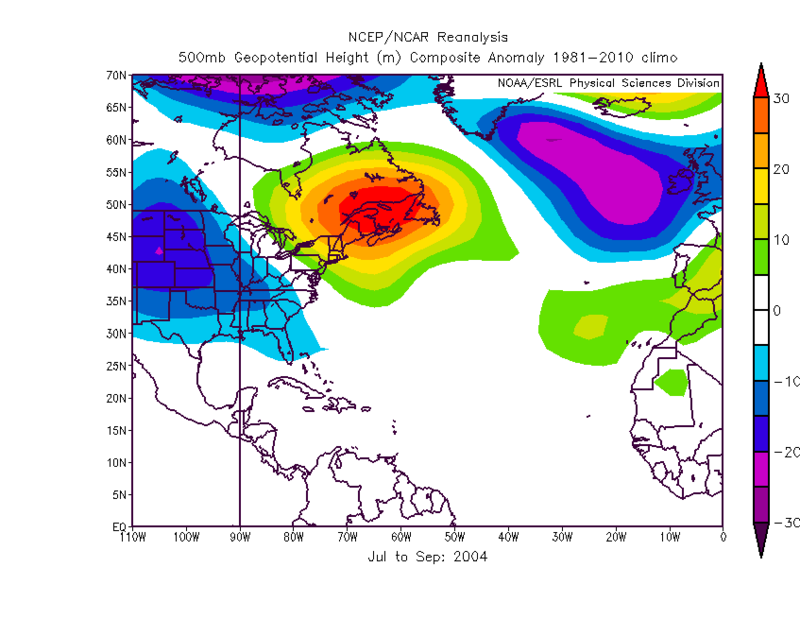
I really don't get the emphasis on colder than normal north Atlantic SSTs. As I pointed out before, 2004 saw such anomalies but we know what happened. Note warmer than normal SSTs in the Western Atlantic around Bermuda and Azores area:

0 likes
-
WPBWeather

- S2K Supporter
- Posts: 535
- Age: 67
- Joined: Thu Jul 18, 2013 12:33 pm
Re: 2016 indicators: Instability / SST's / MSLP / Steering / Sal
gatorcane wrote:I really don't get the emphasis on colder than normal north Atlantic SSTs. As I pointed out before, 2004 saw such anomalies but we know what happened. Note warmer than normal SSTs in the Western Atlantic around Bermuda and Azores area:
It seems the disagreements are on where to look to measure and even what models are accurate for temp measurements. ProMets here on Storm2K disagree and in the greater climo community there is disagreement also.
0 likes
Re: 2016 indicators: Instability / SST's / MSLP / Steering / Sal
TheStormExpert wrote:Ntxw wrote:TheStormExpert wrote:We might have a weaker than normal Azores High but what's the strength of the Bermuda High? That will be key in determining if we see storms recurving out to sea or coming close and or affecting land.
The Azores and Bermuda high's are essentially the same thing. One is an extension of the other. They move and intensify or weaken accordingly. The SST's anoms gives you a hint of where it is likely located.
How was the 2004 hurricane so active in the MDR with such a strong Azores/Bermuda High? One would think there had to be quite a lack of instability and tons of SAL, but there wasn't.
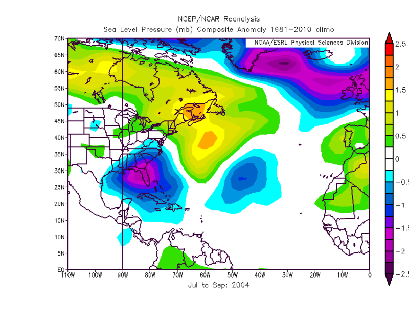
I did a reanalysis from June-Oct 2004. There was much below normal surface pressures of where the Azores high/Bermuda high should be and it was displaced well west (east of Bahamas and off east coast). It actually looks like much weaker than normal high. But the location that it was displaced to is stronger than it relatively is typically thus probably helped steer everything into Florida.

0 likes
The above post and any post by Ntxw is NOT an official forecast and should not be used as such. It is just the opinion of the poster and may or may not be backed by sound meteorological data. It is NOT endorsed by any professional institution including Storm2k. For official information, please refer to NWS products.
Help support Storm2K!
Help support Storm2K!

Re: 2016 indicators: Instability / SST's / MSLP / Steering / Sal
It looks to me that the Azores Surface High was not strong at all during Jul-Sept 2004, ridging was abnormally high across NE US and eastern Canada & extreme NW Atlantic.
0 likes
-
TheStormExpert
Re: 2016 indicators: Instability / SST's / MSLP / Steering / Sal
0 likes
Re: 2016 indicators: Instability / SST's / MSLP / Steering / Sal
TheStormExpert wrote::uarrow: How does this all compare up to this season?
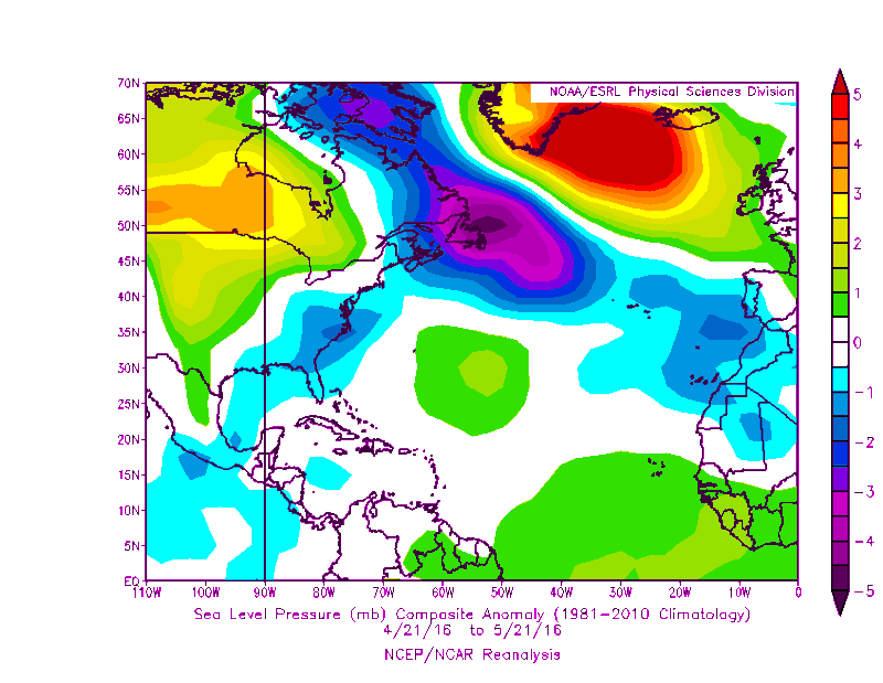
I will hate to make a comparison because season has not started yet and a pattern has not set yet, most models show a strong Azore's High during the hurricane season thus why many think the Atlantic MDR could be below average this season.
But since you asked this is how pressures have run across the Atlantic in average during the past month. Most of the eastern tropical Atlantic pressures have run above average while the Caribbean and GOM have run near average to below average. Pressures just east of Bermuda are running higher than average.
I think the neutral to negative NAO during the past 6 weeks have kept the Azores High at bay so far, maybe why the Atlantic MDR has not cooled as much as many were thinking it was going to do this month.
0 likes
-
HurricaneFan
- Tropical Storm

- Posts: 192
- Age: 42
- Joined: Tue Jan 18, 2011 6:16 pm
- Location: Anguilla,Leeward Islands 18.3N 63.0W
Re: 2016 indicators: Instability / SST's / MSLP / Steering / Sal
Are the models still predicting the NOA to turn positive soon?Why hasn't it turn positive as predicted yet?
0 likes
-
Hurricaneman

- Category 5

- Posts: 7404
- Age: 45
- Joined: Tue Aug 31, 2004 3:24 pm
- Location: central florida
Re: 2016 indicators: Instability / SST's / MSLP / Steering / Sal
According to NESDIS it looks like the PDO is becoming quite a bit less positive and the Atlantic Tripole is becoming more neutral if not slightly positive
PS The CDAS SSTA chart is showing the drop in PDO but not agreeing on the tropical Atlantic with the NESDIS charts
The posts in this forum are NOT official forecast and should not be used as such. They are just the opinion of the poster and may or may not be backed by sound meteorological data. They are NOT endorsed by any professional institution or storm2k.org. For official information, please refer to the NHC and NWS products
0 likes
-
Hurricaneman
- Category 5
- Posts: 7404
- Age: 45
- Joined: Tue Aug 31, 2004 3:24 pm
- Location: central florida
Re: 2016 indicators: Instability / SST's / MSLP / Steering / Sal
The GFS seems to be showing a weak to non existent Bermuda\Azores high, that would be good news if you like tracking Cape verde systems, but who knows that Azores high may come back with gusto and kill off the MDR but if we keep a weak Bermuda\Azores high it could mean recurves of Tropical cyclones from the MDR but as always we need to watch all factors
PS A Bermuda high that sets up between 50 and 60W and 35 to 40N could spell trouble for the US from Eastern Atlantic waves
The posts in this forum are NOT official forecast and should not be used as such. They are just the opinion of the poster and may or may not be backed by sound meteorological data. They are NOT endorsed by any professional institution or storm2k.org. For official information, please refer to the NHC and NWS products
0 likes
-
hurricanehunter69
- Category 1

- Posts: 344
- Joined: Sun May 16, 2010 5:21 pm
- Location: New Orleans
Re: 2016 indicators: Instability / SST's / MSLP / Steering / Sal
you know we're in for a busy season when " Ninel Conde " is NOT writing season cancel posts! ...just sayin?
0 likes
-
ninel conde
Re: 2016 indicators: Instability / SST's / MSLP / Steering / Sal
I predicted 14/8/4 so i dont think it will be slow, but the neg NAO and east coast trof is as strong as ever.
0 likes
Re: 2016 indicators: Instability / SST's / MSLP / Steering / Sal
ninel conde wrote:I predicted 14/8/4 so i dont think it will be slow, but the neg NAO and east coast trof is as strong as ever.
But just because the NAO is negative does not mean that there could be a stronger Bermuda ridge which extends into the NE US like it is doing over the next few days from time to time.
Just a reminder that the NAO was negative through most of the summer of 2004, but the Bermuda ridge was stronger.

0 likes
-
CaliforniaResident
- Tropical Storm
- Posts: 215
- Joined: Fri Feb 21, 2014 1:47 pm
Re: 2016 indicators: Instability / SST's / MSLP / Steering / Sal
Hurricaneman wrote:According to NESDIS it looks like the PDO is becoming quite a bit less positive and the Atlantic Tripole is becoming more neutral if not slightly positive
PS The CDAS SSTA chart is showing the drop in PDO but not agreeing on the tropical Atlantic with the NESDIS charts
The posts in this forum are NOT official forecast and should not be used as such. They are just the opinion of the poster and may or may not be backed by sound meteorological data. They are NOT endorsed by any professional institution or storm2k.org. For official information, please refer to the NHC and NWS products
I think the PDO will drop like a rock very quickly over the summer and revert a long lasting negative phase for years to come and the climatic patterns that go with the negative PDO will resume course as well.
0 likes
-
Kingarabian

- S2K Supporter
- Posts: 16355
- Joined: Sat Aug 08, 2009 3:06 am
- Location: Honolulu, Hawaii
Re: 2016 indicators: Instability / SST's / MSLP / Steering / Sal
CaliforniaResident wrote:Hurricaneman wrote:According to NESDIS it looks like the PDO is becoming quite a bit less positive and the Atlantic Tripole is becoming more neutral if not slightly positive
PS The CDAS SSTA chart is showing the drop in PDO but not agreeing on the tropical Atlantic with the NESDIS charts
The posts in this forum are NOT official forecast and should not be used as such. They are just the opinion of the poster and may or may not be backed by sound meteorological data. They are NOT endorsed by any professional institution or storm2k.org. For official information, please refer to the NHC and NWS products
I think the PDO will drop like a rock very quickly over the summer and revert a long lasting negative phase for years to come and the climatic patterns that go with the negative PDO will resume course as well.
No evidence at all that the PDO is going to drop anytime soon.
0 likes
RIP Kobe Bryant
-
Yellow Evan

- Professional-Met

- Posts: 16232
- Age: 27
- Joined: Fri Jul 15, 2011 12:48 pm
- Location: Henderson, Nevada/Honolulu, HI
- Contact:
Re: 2016 indicators: Instability / SST's / MSLP / Steering / Sal
CaliforniaResident wrote:I think the PDO will drop like a rock very quickly over the summer and revert a long lasting negative phase for years to come and the climatic patterns that go with the negative PDO will resume course as well.
There is likely no turning back at this point, given the PDO records of the last 2 years and the negative PDO from 1998-2013 makes me think we are in a +PDO era again and will stay that way for another 7-10+ years.
0 likes
Who is online
Users browsing this forum: Google Adsense [Bot], Ntxw, WaveBreaking and 377 guests