Broad area of disturbed weather in the Western Caribbean Sea (Is INVEST 91L)

This is the general tropical discussion area. Anyone can take their shot at predicting a storms path.

Moderator: S2k Moderators

Forum rules

The posts in this forum are NOT official forecasts and should not be used as such. They are just the opinion of the poster and may or may not be backed by sound meteorological data. They are NOT endorsed by any professional institution or STORM2K. For official information, please refer to products from the National Hurricane Center and National Weather Service.

Help Support Storm2K
Message
Author
User avatar
cycloneye
Admin
Admin
Posts: 145313
Age: 68
Joined: Thu Oct 10, 2002 10:54 am
Location: San Juan, Puerto Rico

Re: Broad area of disturbed weather in the Western Caribbean Sea

#481 Postby cycloneye » Wed Oct 03, 2018 12:45 pm

2 PM TWO:

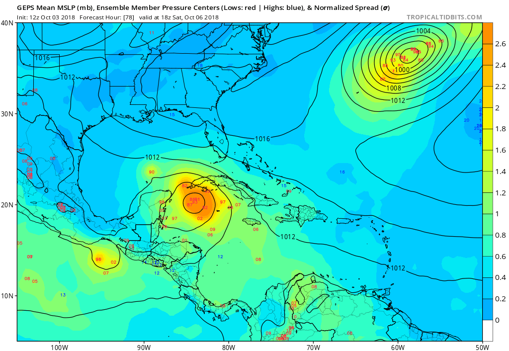
A broad area of low pressure covers the central and southwestern
Caribbean Sea, and portions of Central America. Showers and
thunderstorms remain disorganized, however, some slow development
within this broad circulation is possible this weekend and early
next week as it drifts northwestward.
* Formation chance through 48 hours...low...near 0 percent.
* Formation chance through 5 days...low...30 percent.
0 likes   
Visit the Caribbean-Central America Weather Thread where you can find at first post web cams,radars
and observations from Caribbean basin members Click Here

LarryWx
S2K Supporter
S2K Supporter
Posts: 6305
Joined: Sun Sep 07, 2003 2:04 pm
Location: GA

Re: Broad area of disturbed weather in the Western Caribbean Sea

#482 Postby LarryWx » Wed Oct 03, 2018 12:46 pm

12Z GEFS has several members as TD or TS near or on FL E coast 10/11-13 fwiw
0 likes   
Personal Forecast Disclaimer:
The posts in this forum are NOT official forecasts and should not be used as such. They are just the opinion of the poster and may or may not be backed by sound meteorological data. They are NOT endorsed by any professional institution or storm2k.org. For official information, please refer to the NHC and NWS products.

User avatar
northjaxpro
S2K Supporter
S2K Supporter
Posts: 8900
Joined: Mon Sep 27, 2010 11:21 am
Location: Jacksonville, FL

Re: Broad area of disturbed weather in the Western Caribbean Sea

#483 Postby northjaxpro » Wed Oct 03, 2018 12:47 pm

NHC still keeps development probs at 30% for next 5 days.
0 likes   
NEVER, EVER SAY NEVER in the tropics and weather in general, and most importantly, with life itself!!

________________________________________________________________________________________

Fay 2008 Beryl 2012 Debby 2012 Colin 2016 Hermine 2016 Julia 2016 Matthew 2016 Irma 2017 Dorian 2019

User avatar
SFLcane
S2K Supporter
S2K Supporter
Posts: 10163
Age: 47
Joined: Sat Jun 05, 2010 1:44 pm
Location: Lake Worth Florida

Re: Broad area of disturbed weather in the Western Caribbean Sea

#484 Postby SFLcane » Wed Oct 03, 2018 12:53 pm

It actually looks like this might develop in the eastern pacific. Its all speculation at this point
0 likes   

User avatar
chris_fit
Category 5
Category 5
Posts: 3222
Age: 42
Joined: Wed Sep 10, 2003 11:58 pm
Location: Tampa Bay Area, FL

Re: Broad area of disturbed weather in the Western Caribbean Sea

#485 Postby chris_fit » Wed Oct 03, 2018 1:08 pm

Looks like the 12Z Euro is very similar to the 12z CMC in regards to track through 72 hours. CMC is much stronger than the Euro though.
0 likes   

OuterBanker
S2K Supporter
S2K Supporter
Posts: 1731
Joined: Wed Feb 26, 2003 10:53 am
Location: Nags Head, NC
Contact:

Re: Broad area of disturbed weather in the Western Caribbean Sea

#486 Postby OuterBanker » Wed Oct 03, 2018 1:11 pm

CMC is the lone wolf with a LA/Tx hit.

lol, and it still has Leslie hanging around.

Looks like Leslie will be fitted for a Halloween costume.
1 likes   

User avatar
CyclonicFury
Category 5
Category 5
Posts: 2025
Age: 26
Joined: Sun Jul 02, 2017 12:32 pm
Location: NC
Contact:

Re: Broad area of disturbed weather in the Western Caribbean Sea

#487 Postby CyclonicFury » Wed Oct 03, 2018 1:13 pm

While I would say chances of development appear to be deceasing on model runs, you have to remember the potential time for genesis is still 3-4 days away. It is too soon to write this system off (and the rest of the season, it's only early October) at this time.
0 likes   
NCSU B.S. in Meteorology Class of 2021. Tropical weather blogger at http://www.cyclonicfury.com. My forecasts and thoughts are NOT official, for official forecasts please consult the National Hurricane Center.

User avatar
wxman57
Moderator-Pro Met
Moderator-Pro Met
Posts: 22978
Age: 67
Joined: Sat Jun 21, 2003 8:06 pm
Location: Houston, TX (southwest)

Re: Broad area of disturbed weather in the Western Caribbean Sea

#488 Postby wxman57 » Wed Oct 03, 2018 1:13 pm

I trust the Canadian model about 1/10th as far as I can throw it. The disturbance is looking less impressive today, and models are less bullish on any development. Something to keep an eye on, but not something to worry too much about yet.
7 likes   

User avatar
toad strangler
S2K Supporter
S2K Supporter
Posts: 4543
Joined: Sun Jul 28, 2013 3:09 pm
Location: Earth
Contact:

Re: Broad area of disturbed weather in the Western Caribbean Sea

#489 Postby toad strangler » Wed Oct 03, 2018 1:32 pm

12z Euro

crickets
0 likes   

Aric Dunn
Category 5
Category 5
Posts: 21238
Age: 42
Joined: Sun Sep 19, 2004 9:58 pm
Location: Ready for the Chase.
Contact:

Re: Broad area of disturbed weather in the Western Caribbean Sea

#490 Postby Aric Dunn » Wed Oct 03, 2018 1:36 pm

toad strangler wrote:12z Euro

crickets


lol just be patient. because models have never flipped back and forth before :P
3 likes   
Note: If I make a post that is brief. Please refer back to previous posts for the analysis or reasoning. I do not re-write/qoute what my initial post said each time.
If there is nothing before... then just ask :)

Space & Atmospheric Physicist, Embry-Riddle Aeronautical University,
I believe the sky is falling...

stormlover2013

Re: Broad area of disturbed weather in the Western Caribbean Sea

#491 Postby stormlover2013 » Wed Oct 03, 2018 1:50 pm

one thing i notice from the Euro that ridge is strong for OCT in the se, looks strong till next thursday.
0 likes   

LarryWx
S2K Supporter
S2K Supporter
Posts: 6305
Joined: Sun Sep 07, 2003 2:04 pm
Location: GA

Re: Broad area of disturbed weather in the Western Caribbean Sea

#492 Postby LarryWx » Wed Oct 03, 2018 1:54 pm

stormlover2013 wrote:one thing i notice from the Euro that ridge is strong for OCT in the se, looks strong till next thursday.


The atmosphere over and SSTs near the SE US are and will continue to be much more typical of August than October. What an anomalous pattern!

Euro not doing much near FL 10/10-13 but there continues to be good moisture flowing off the Atlantic below the anomalous upper high. Still going to watch this area for this period.
0 likes   
Personal Forecast Disclaimer:
The posts in this forum are NOT official forecasts and should not be used as such. They are just the opinion of the poster and may or may not be backed by sound meteorological data. They are NOT endorsed by any professional institution or storm2k.org. For official information, please refer to the NHC and NWS products.

stormlover2013

Re: Broad area of disturbed weather in the Western Caribbean Sea

#493 Postby stormlover2013 » Wed Oct 03, 2018 1:56 pm

LarryWx wrote:
stormlover2013 wrote:one thing i notice from the Euro that ridge is strong for OCT in the se, looks strong till next thursday.


The atmosphere over and SSTs near the SE US are and will continue to be much more typical of August than October. What an anomalous pattern!


no doubt about that
0 likes   

stormlover2013

Re: Broad area of disturbed weather in the Western Caribbean Sea

#494 Postby stormlover2013 » Wed Oct 03, 2018 1:59 pm

this is why i always tell me to not trust a model past 5 days....this is what you get right here lol
0 likes   

User avatar
gatorcane
S2K Supporter
S2K Supporter
Posts: 23691
Age: 47
Joined: Sun Mar 13, 2005 3:54 pm
Location: Boca Raton, FL

Re: Broad area of disturbed weather in the Western Caribbean Sea

#495 Postby gatorcane » Wed Oct 03, 2018 1:59 pm

Strong signal from the GEPS in just 78 hours:

Image
1 likes   

stormlover2013

Re: Broad area of disturbed weather in the Western Caribbean Sea

#496 Postby stormlover2013 » Wed Oct 03, 2018 2:04 pm

Euro ensembles will shift west.... we should know in about hour
0 likes   

User avatar
CourierPR
Category 5
Category 5
Posts: 1335
Age: 71
Joined: Tue Aug 31, 2004 7:53 pm
Location: Pompano Beach, Florida

Re: Broad area of disturbed weather in the Western Caribbean Sea

#497 Postby CourierPR » Wed Oct 03, 2018 2:06 pm

stormlover2013 wrote:Euro ensembles will shift west.... we should know in about hour


What are you basing that on?
0 likes   

stormlover2013

Re: Broad area of disturbed weather in the Western Caribbean Sea

#498 Postby stormlover2013 » Wed Oct 03, 2018 2:09 pm

CourierPR wrote:
stormlover2013 wrote:Euro ensembles will shift west.... we should know in about hour


What are you basing that on?


The strong ridge that the EURO is showing, CMC, GFS, all show it also
0 likes   

User avatar
CourierPR
Category 5
Category 5
Posts: 1335
Age: 71
Joined: Tue Aug 31, 2004 7:53 pm
Location: Pompano Beach, Florida

Re: Broad area of disturbed weather in the Western Caribbean Sea

#499 Postby CourierPR » Wed Oct 03, 2018 2:20 pm

stormlover2013 wrote:
CourierPR wrote:
stormlover2013 wrote:Euro ensembles will shift west.... we should know in about hour


What are you basing that on?


The strong ridge that the EURO is showing, CMC, GFS, all show it also


I believe I saw some models showing a cold front entering the picture in roughly 10 days. Any west shift may be temporary and it always helps to have a developing system that the models can track.
0 likes   

User avatar
cycloneye
Admin
Admin
Posts: 145313
Age: 68
Joined: Thu Oct 10, 2002 10:54 am
Location: San Juan, Puerto Rico

Re: Broad area of disturbed weather in the Western Caribbean Sea

#500 Postby cycloneye » Wed Oct 03, 2018 2:21 pm

SFLcane wrote:It actually looks like this might develop in the eastern pacific. Its all speculation at this point


NHC mentions that in EPAC TWO.

The western portion of the broad area of low pressure over the
western Caribbean Sea and Central America extends into the extreme
eastern North Pacific. Some slow development of this system is
possible this weekend and early next week while it drifts
northwestward.
* Formation chance through 48 hours...low...near 0 percent.
* Formation chance through 5 days...low...20 percent.
0 likes   
Visit the Caribbean-Central America Weather Thread where you can find at first post web cams,radars
and observations from Caribbean basin members Click Here


Return to “Talkin' Tropics”

Who is online

Users browsing this forum: duilaslol, Hypercane_Kyle, REDHurricane, WaveBreaking and 45 guests