Insane warming, as of the moment. Niño 1+2 cooled a tiny bit, Niño 4 warmed a tiny bit while Niño 3.4 & 3 warm significantly.
Niño 4: +0.73
Niño 3.4: +0.75
Niño 3: +1.01
Niño 1+2: +1.68
ENSO Updates (2007 thru 2023)
Moderator: S2k Moderators
Forum rules

The posts in this forum are NOT official forecasts and should not be used as such. They are just the opinion of the poster and may or may not be backed by sound meteorological data. They are NOT endorsed by any professional institution or STORM2K. For official information, please refer to products from the National Hurricane Center and National Weather Service.
-
xtyphooncyclonex

- Category 5

- Posts: 3891
- Age: 24
- Joined: Sat Dec 08, 2012 9:07 am
- Location: Cebu City
- Contact:
Last edited by xtyphooncyclonex on Thu Jun 19, 2014 8:19 pm, edited 1 time in total.
0 likes
REMINDER: My opinions that I, or any other NON Pro-Met in this forum, are unofficial. Please do not take my opinions as an official forecast and warning. I am NOT a meteorologist. Following my forecasts blindly may lead to false alarm, danger and risk if official forecasts from agencies are ignored.


Re:
xtyphooncyclonex wrote:Insane warming, as of the moment. Niño 1+2 cooled a tiny bit, Niño 4 warmed a tiny bit while Niño 3.4 & 3 warm significantly.
Niño 4: +0.73
Niño 3.4: +0.75
Niño 3: +1.02
Niño 1+2: +1.67
I will be interested to see Monday's update. The buoys are going one way, satellite is going the opposite way (though I am more certain buoys is likely an error due to it's history of doing this). One is right and the other is wrong! Should we take the middle ground?
0 likes
The above post and any post by Ntxw is NOT an official forecast and should not be used as such. It is just the opinion of the poster and may or may not be backed by sound meteorological data. It is NOT endorsed by any professional institution including Storm2k. For official information, please refer to NWS products.
Help support Storm2K!
Second week of June was dominated by stronger anomalous easterlies (blues) resulting in the recent cooling. Does look like that period has ended and we are heading back towards westerlies (yellow and orange) for the dateline moving eastward, central Pacific.

0 likes
The above post and any post by Ntxw is NOT an official forecast and should not be used as such. It is just the opinion of the poster and may or may not be backed by sound meteorological data. It is NOT endorsed by any professional institution including Storm2k. For official information, please refer to NWS products.
Help support Storm2K!
Help support Storm2K!
-
xtyphooncyclonex
- Category 5
- Posts: 3891
- Age: 24
- Joined: Sat Dec 08, 2012 9:07 am
- Location: Cebu City
- Contact:
I don't get why CFSv2 is expecting the warm subsurface pool to shrink A LOT by July, in fact, their bullish forecasts previously have shown cooler than what is happening, and that the 5C anomalies have remained in place. They also predict a big cooling, as they averaged members, one outlier goes through a moderate La Niña, and making the El Niño forecast weaker.
0 likes
REMINDER: My opinions that I, or any other NON Pro-Met in this forum, are unofficial. Please do not take my opinions as an official forecast and warning. I am NOT a meteorologist. Following my forecasts blindly may lead to false alarm, danger and risk if official forecasts from agencies are ignored.
-
xtyphooncyclonex
- Category 5
- Posts: 3891
- Age: 24
- Joined: Sat Dec 08, 2012 9:07 am
- Location: Cebu City
- Contact:
Latest graphic shows this 
Niño 1+2: +1.59°
Niño 3: +1.17°
Niño 3.4: +0.87°
Niño 4: +0.76°
Niño 1+2: +1.59°
Niño 3: +1.17°
Niño 3.4: +0.87°
Niño 4: +0.76°
0 likes
REMINDER: My opinions that I, or any other NON Pro-Met in this forum, are unofficial. Please do not take my opinions as an official forecast and warning. I am NOT a meteorologist. Following my forecasts blindly may lead to false alarm, danger and risk if official forecasts from agencies are ignored.

Re:
xtyphooncyclonex wrote:Latest graphic shows this
Niño 1+2: +1.59°
Niño 3: +1.17°
Niño 3.4: +0.87°
Niño 4: +0.76°
Super El Nino Cancel Cancel
Now to be serious we must all wait a couple of days to assess what exactly is going on with an apparent massive warming. Is it the satellites or is it something short lived? Let's just wait a few days to establish a pattern. Pro Mets: What do you think is going on with the apparent massive warming?
0 likes
This post is NOT AN OFFICIAL FORECAST and should not be used as such. It is just the opinion of the poster and may or may not be backed by sound meteorological data. It is NOT endorsed by any professional institution including storm2k.org. For Official Information please refer to the NHC and NWS products.
Re: ENSO: CPC 6/2/14: Nino 3.4 up to +0.6C
Ntxw wrote:Looks like NOAA has been doing some updating to the RTG SST maps. Remember to look at the scale, the colors may be a little more dramatic than before (darker) but it's much better than the previous product which you had to do more guessing with some blended colors.
Aside we should get a PDO reading here in within the next 2 weeks for May, should come out as another positive value for the fifth consecutive month. June looks to be locked in for the 6th but that's for next month.


Yeah I definitely like the new maps, much easier to track ssta. One problem though, I think NOAA should add more intervals between the 4 and 8. The scale goes by .25's and then .5's and then jumps from 4 to 8. It would be useful to have more intervals between 4 and 8, perhaps after 4 going by intervals of 1.
0 likes
This post is NOT AN OFFICIAL FORECAST and should not be used as such. It is just the opinion of the poster and may or may not be backed by sound meteorological data. It is NOT endorsed by any professional institution including storm2k.org. For Official Information please refer to the NHC and NWS products.
Re: ENSO Updates
Folks,
This sudden warming showing up on OISST based maps and not on the TAO buoys is reminding me of the false warming that was on OISST based maps back in Nov. of 2012 and not on TAO! Back then, Ntxw and myself were intensely discussing this. OISST fooled me as I said this: "El Nino is NOT even close to being dead now!" in here:
viewtopic.php?f=31&t=92137&st=0&sk=t&sd=a&start=2726
Based on OISST, I had guessed that 3.4 would warm from +0.4 to the +0.8 to +1.0 range in that NOAA weekly update. However, it turned out that NOAA warmed it only to +0.5. Even Ntxw had said this about the only weak warming on 11/19/12 here:
viewtopic.php?f=31&t=92137&st=0&sk=t&sd=a&start=2730
"If that is the case, there is something very wrong. There is no charts or satellite maps that depict anything less than 0.7, heck even less than 0.9 seems weird. We should look back at the other weeks that showed warming yet didn't happen with the CPC, very fishy."
A person at NOAA told me this on the phone per this post:
viewtopic.php?f=31&t=92137&st=0&sk=t&sd=a&start=2734
"She said that there was "a bug in the data". The data has been rerun. So, they clearly think that OISST was erroneous."
In other words, NOAA considered the OISST based warming to be false and, instead, went with the cooler buoys.
Subsequent to this, the OISST maps cooled all the way back down as fast as they had warmed and suggested that they were tainted with false data somehow. As we know, no Nino ever materialized that fall/winter and in contrast, it continued cooling all the way to neutral negative by December.
The point of this post is to suggest the supposed intense warming be taken with a grain at least until NOAA releases its next couple of weeklies. I'm not going to get fooled a second time.
0 likes
Personal Forecast Disclaimer:
The posts in this forum are NOT official forecasts and should not be used as such. They are just the opinion of the poster and may or may not be backed by sound meteorological data. They are NOT endorsed by any professional institution or storm2k.org. For official information, please refer to the NHC and NWS products.
The posts in this forum are NOT official forecasts and should not be used as such. They are just the opinion of the poster and may or may not be backed by sound meteorological data. They are NOT endorsed by any professional institution or storm2k.org. For official information, please refer to the NHC and NWS products.
-
Kingarabian

- S2K Supporter

- Posts: 16364
- Joined: Sat Aug 08, 2009 3:06 am
- Location: Honolulu, Hawaii
Re: ENSO Updates
LarryWx wrote:Folks,
This sudden warming showing up on OISST based maps and not on the TAO buoys is reminding me of the false warming that was on OISST based maps back in Nov. of 2012 and not on TAO! Back then, Ntxw and myself were intensely discussing this. OISST fooled me as I said this: "El Nino is NOT even close to being dead now!" in here:
viewtopic.php?f=31&t=92137&st=0&sk=t&sd=a&start=2726
Based on OISST, I had guessed that 3.4 would warm from +0.4 to the +0.8 to +1.0 range in that NOAA weekly update. However, it turned out that NOAA warmed it only to +0.5. Even Ntxw had said this about the only weak warming on 11/19/12 here:
viewtopic.php?f=31&t=92137&st=0&sk=t&sd=a&start=2730
"If that is the case, there is something very wrong. There is no charts or satellite maps that depict anything less than 0.7, heck even less than 0.9 seems weird. We should look back at the other weeks that showed warming yet didn't happen with the CPC, very fishy."
A person at NOAA told me this on the phone per this post:
viewtopic.php?f=31&t=92137&st=0&sk=t&sd=a&start=2734
"She said that there was "a bug in the data". The data has been rerun. So, they clearly think that OISST was erroneous."
In other words, NOAA considered the OISST based warming to be false and, instead, went with the cooler buoys.
Subsequent to this, the OISST maps cooled all the way back down as fast as they had warmed and suggested that they were tainted with false data somehow. As we know, no Nino ever materialized that fall/winter and in contrast, it continued cooling all the way to neutral negative by December.
The point of this post is to suggest the supposed intense warming be taken with a grain at least until NOAA releases its next couple of weeklies. I'm not going to get fooled a second time.
I recall that scenario as if it were yesterday. Shame that 2 years later, this bug still exists.
0 likes
RIP Kobe Bryant
Re: ENSO Updates
LarryWx wrote: The point of this post is to suggest the supposed intense warming be taken with a grain at least until NOAA releases its next couple of weeklies. I'm not going to get fooled a second time.
This is a very good reminder, partially why in a previous post I've been hesitant to fully comply since the change was so drastic. I remember that time well. Unfortunately we don't have the buoys like we did then (they have deteriorated, and even recently have falsely showed cold anomalies a few weeks ago). We'll just have to wait for the CPC updates to know what is really going on.
I would suggest using NCEP's RTG product as it incorporates a myriad of data collection and probably less prone to errors from a singular source. It's been much more steady.
http://polar.ncep.noaa.gov/sst/rtg_low_res/
Last edited by Ntxw on Fri Jun 20, 2014 1:23 am, edited 1 time in total.
0 likes
The above post and any post by Ntxw is NOT an official forecast and should not be used as such. It is just the opinion of the poster and may or may not be backed by sound meteorological data. It is NOT endorsed by any professional institution including Storm2k. For official information, please refer to NWS products.
Help support Storm2K!
Help support Storm2K!
-
xtyphooncyclonex
- Category 5
- Posts: 3891
- Age: 24
- Joined: Sat Dec 08, 2012 9:07 am
- Location: Cebu City
- Contact:
So maybe the graphic might be at +0.6 officially? I knew it was a glitch, as it is very unlikely that the warming would be that very rapid.
0 likes
REMINDER: My opinions that I, or any other NON Pro-Met in this forum, are unofficial. Please do not take my opinions as an official forecast and warning. I am NOT a meteorologist. Following my forecasts blindly may lead to false alarm, danger and risk if official forecasts from agencies are ignored.
-
South Texas Storms

- Professional-Met

- Posts: 4258
- Joined: Thu Jun 24, 2010 12:28 am
- Location: Houston, TX
Re: ENSO Updates
CFSv2 is indicating westerly winds in the Nino regions during the next 2 weeks.

Uploaded with ImageShack.us

Uploaded with ImageShack.us
0 likes
-
CaliforniaResident
- Tropical Storm

- Posts: 215
- Joined: Fri Feb 21, 2014 1:47 pm
Here's one just for fun:
What do you think are the chances in terms of percentages for each of the following for the 2014-2015 season based on the conditions as of June 20, 2014?
1) A Super record El Nino on par with 1997-1998 or stronger
2) A strong El Nino
3) A Moderate El Nino
4) A Weak El Nino
5) Neutral Conditions
6) La Nina
My personal guess
1) around 1 percent
2) around 10 percent
3) around 40 percent
4) around 30 percent
5) around 15 percent
6) around 4 percent
I invite others to make similar guesses...
0 likes
-
Steve820

- Tropical Storm
- Posts: 188
- Age: 26
- Joined: Sat May 17, 2014 8:04 pm
- Location: Southern California
- Contact:
Re:
CaliforniaResident wrote:Here's one just for fun:
What do you think are the chances in terms of percentages for each of the following for the 2014-2015 season based on the conditions as of June 20, 2014?
1) A Super record El Nino on par with 1997-1998 or stronger
2) A strong El Nino
3) A Moderate El Nino
4) A Weak El Nino
5) Neutral Conditions
6) La Nina
My personal guess
1) around 1 percent
2) around 10 percent
3) around 40 percent
4) around 30 percent
5) around 15 percent
6) around 4 percent
I invite others to make similar guesses...
My guesses:
1) 1 percent
2) 12 percent
3) 40 percent
4) 27 percent
5) 15 percent
6) 5 percent
I'm thinking we'll most likely see a weak to moderate El Nino this year.
0 likes
Hurricanes are an amazing natural phenomena. While many are spiraling pits of evil that kill people or cause devastation, some are tame and stay clear of land.
I wish for you to
I wish for you to
-
xtyphooncyclonex
- Category 5
- Posts: 3891
- Age: 24
- Joined: Sat Dec 08, 2012 9:07 am
- Location: Cebu City
- Contact:
Re:
CaliforniaResident wrote:Here's one just for fun:
What do you think are the chances in terms of percentages for each of the following for the 2014-2015 season based on the conditions as of June 20, 2014?
1) A Super record El Nino on par with 1997-1998 or stronger
2) A strong El Nino
3) A Moderate El Nino
4) A Weak El Nino
5) Neutral Conditions
6) La Nina
My personal guess
1) around 1 percent
2) around 10 percent
3) around 40 percent
4) around 30 percent
5) around 15 percent
6) around 4 percent
I invite others to make similar guesses...
1) 5%
2) 25%
3) 45%
4) 20%
5) 5%
6) Definitely zero
I said zero for the bust because the subsurface is too warm, the PDO is very positive, the atmosphere is starting to cooperate and coincide with the Pacific ENSO warming, and that the MEI is very positive.
0 likes
REMINDER: My opinions that I, or any other NON Pro-Met in this forum, are unofficial. Please do not take my opinions as an official forecast and warning. I am NOT a meteorologist. Following my forecasts blindly may lead to false alarm, danger and risk if official forecasts from agencies are ignored.
-
AJC3

- Admin

- Posts: 4155
- Age: 62
- Joined: Tue Aug 31, 2004 7:04 pm
- Location: Ballston Spa, New York
- Contact:
Re: ENSO Updates
South Texas Storms wrote:CFSv2 is indicating westerly winds in the Nino regions during the next 2 weeks.
Uploaded with ImageShack.us
Just to be clear for those that are likely to misinterpret that map, what are being displayed are not wind barbs. They are vector anomalies. If one assumes an climatological mean wind out of the east at roughly 15kt (8 m/s) in the equatorial EPAC, then only westerly wind anomalies with a magnitude above that value would be true westerly winds. Assuming my climo approximation is close (anyone?), this means the only area on that map within the ENSO regions that would have any westerly winds is shaded in medium red (6-10 m/s) from around 160E to 170W between the equator and 10N, and may be smaller in area than that. The remainder of that area with positive westerly anomalies would simply have weaker easterlies than normal.
0 likes
Re: ENSO Updates
According to the link below, the current calendar week's averaged 3.4 SST anom., which will be released Monday by NOAA, is +0.6:
http://www.tropicaltidbits.com/analysis/nino34.png
Let's see if NOAA raises it from last week's +0.4 to +0.6. That wouldn't be surprising as that isn't that much of a rise. More importantly, let's see what happens in the subsequent week and how this graph evolves over the next week or so. After such a steep rise, I wouldn't be surprised if there is some drop back pretty quickly. Regardless, I'd take this graph with a grain, partially because dailies are volatile/what happened in 2012 suggested a false warming, and put more emphasis on what NOAA does. The number to be released a week from Monday will be more interesting.
0 likes
Personal Forecast Disclaimer:
The posts in this forum are NOT official forecasts and should not be used as such. They are just the opinion of the poster and may or may not be backed by sound meteorological data. They are NOT endorsed by any professional institution or storm2k.org. For official information, please refer to the NHC and NWS products.
The posts in this forum are NOT official forecasts and should not be used as such. They are just the opinion of the poster and may or may not be backed by sound meteorological data. They are NOT endorsed by any professional institution or storm2k.org. For official information, please refer to the NHC and NWS products.
-
Yellow Evan

- Professional-Met
- Posts: 16240
- Age: 27
- Joined: Fri Jul 15, 2011 12:48 pm
- Location: Henderson, Nevada/Honolulu, HI
- Contact:
Re:
Alyono wrote:west winds in the CPAC could created favorable low level winds for TC formation, couldn't they?
GFs has been hinting a possible TC there, yes.
0 likes
Re: ENSO Updates
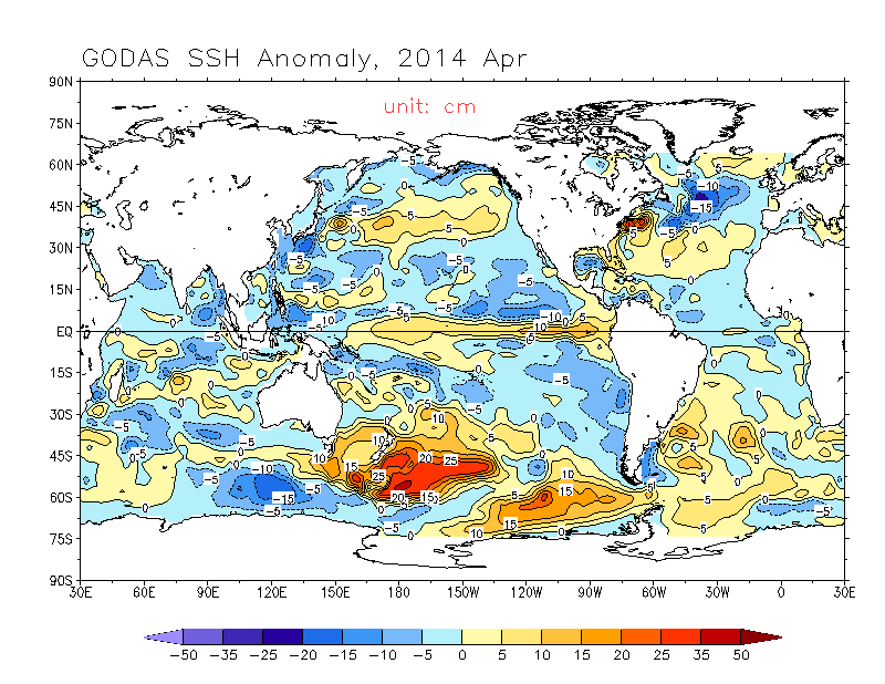
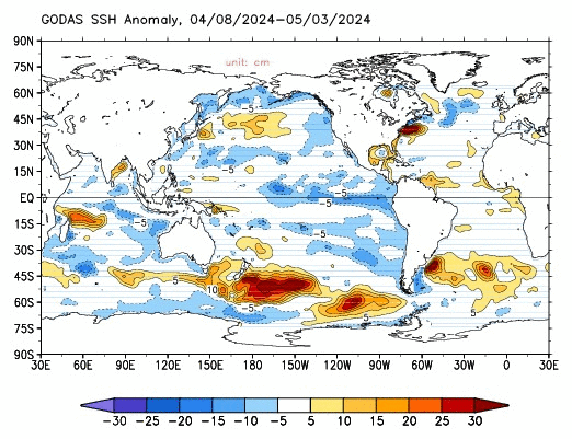
This looks much weaker than it did in early April. I remember when some people were expecting a "super" el nino to develop. But now, sea height anomalies have diminished to below 2009 levels-and decreasing still, SOI remains consistently positive, and the warming is now well behind 1997-and are now only slightly ahead of 2009. Subsurface temperature anomalies have also diminished considerably. In addition, the past 30 day average wind anomalies have been easterly over the central equatorial Pacific. My opinion is that this will develop but it will between somewhere between 2006 and 2009 in strength-probably with around 1.2 degrees C as the peak nino3.4 anomaly. -but that is just my opinion.
Does anyone have any thoughts on what caused this lessening? Could it be the fact that SST anomalies have been fairly negative in the South Pacific immediately below the equator all year? Therefore making it hard for SOI to become negative and for strong westerly wind anomalies to develop?
Here are the Sea level height anomalies for April 2014 and for the last 30 days (respectively). Notice the decrease in SSH anomalies. Similarly,the depth of the 20 degree C thermocline in the east and central equatorial Pacific has responded in a similar way.
Personal Forecast Disclaimer:
The posts in this forum are NOT official forecast and should not be used as such. They are just the opinion of the poster and may or may not be backed by sound meteorological data. They are NOT endorsed by any professional institution or storm2k.org. For official information, please refer to the NHC and NWS products.
0 likes
All posts by Dean_175 are NOT official forecasts and should not be used as such. They are just the opinion of the poster and may or may not be backed by sound meteorological data. They are NOT endorsed by any professional institution or storm2k.org. For official information, please refer to the NHC and NWS products.
Who is online
Users browsing this forum: No registered users and 184 guests