
I know a lot of people may be cautious to speculate on intensity during this time of the year- espescially after last year's near failure to develop at all- but could this el nino become as strong as 1997(ONI >2.0)-or is that still a very unlikely event? Not only are subsurface temperatures extremely warm , but we have had a series of strong WWB as well as sustained westerly wind anomalies across the equatorial Pacific. This is unlike last year in which the atmosphere was not responding at all- and easterly anomalies were observed through spring and summer. Not only that , but all nino regions are already warm.
I am not saying that I expect an event like that this year- but it seems that conditions this year look just as "good" or better than last year when a lot of people were saying they were expecting a very strong el nino to develop. Yet right now, nobody seems to be talking about that. None of the "hype" this year.
ENSO Updates (2007 thru 2023)
Moderator: S2k Moderators
Forum rules

The posts in this forum are NOT official forecasts and should not be used as such. They are just the opinion of the poster and may or may not be backed by sound meteorological data. They are NOT endorsed by any professional institution or STORM2K. For official information, please refer to products from the National Hurricane Center and National Weather Service.
0 likes
All posts by Dean_175 are NOT official forecasts and should not be used as such. They are just the opinion of the poster and may or may not be backed by sound meteorological data. They are NOT endorsed by any professional institution or storm2k.org. For official information, please refer to the NHC and NWS products.


Re:
Dean_175 wrote:I am not saying that I expect an event like that this year- but it seems that conditions this year look just as "good" or better than last year when a lot of people were saying they were expecting a very strong el nino to develop. Yet right now, nobody seems to be talking about that. None of the "hype" this year.
It's a possibility, you're right we've all been spooked after last year. It takes a set of just perfect circumstances to develop a Nino that big it seems. The Ocean is only half the story we've learned the atmosphere needs to keep it going. 3.4 is still warming very slowly, if that picks up pace substantially through April and into May I think people will be less hesitant to mention it.
0 likes
The above post and any post by Ntxw is NOT an official forecast and should not be used as such. It is just the opinion of the poster and may or may not be backed by sound meteorological data. It is NOT endorsed by any professional institution including Storm2k. For official information, please refer to NWS products.
Help support Storm2K!
-
xtyphooncyclonex

- Category 5

- Posts: 3891
- Age: 24
- Joined: Sat Dec 08, 2012 9:07 am
- Location: Cebu City
- Contact:
Re: ENSO: CPC 3/30/15 update: El Nino remains at +0.6C
Interesting. They say a moderate El Niño is likely in the next few weeks, and there's a strong WWB over the WPAC enhanced by Super Typhoon Maysak.
Little change to Weather Pattern as El Niño Strengthens
http://www.wunderground.com/blog/SteveG ... ef=Default
Though reluctant to make a definitive forecast for El Niño beyond the next few weeks due to the generally poor skill for ENSO forecasts during the spring – it certainly appears that we could be in for a moderate or even a strong El Niño by early summer.
The very strong westerly wind burst in the WPAC last week (partially due to the 2 tropical cyclones) has broadened out, with low level westerly anomalies now common across most of the Pacific. SST anomalies are now increasing over the EPAC, with sub-surface warming continuing to intensify and broaden across much of the Pacific. With this continuing warming trend and apparently more persistent low level westerlies, most models continue to forecast a moderate or even strong El Niño to develop by summer.
The most recent global SST anomaly chart from 2 days ago shows a strongly positive PDO pattern, with an increasing significant El Niño superimposed on it. Even though SST’s are still only modestly above normal in Niño region 3, the combined Niño 3.4 region now has an ONI value of +0.6. At the current rate of warming, a weekly Niño 3.4 reading approaching +1.0 within a few weeks is quite possible.
0 likes
REMINDER: My opinions that I, or any other NON Pro-Met in this forum, are unofficial. Please do not take my opinions as an official forecast and warning. I am NOT a meteorologist. Following my forecasts blindly may lead to false alarm, danger and risk if official forecasts from agencies are ignored.
-
xtyphooncyclonex
- Category 5
- Posts: 3891
- Age: 24
- Joined: Sat Dec 08, 2012 9:07 am
- Location: Cebu City
- Contact:
Probably strongest WWB? Maysak is now the strongest storm prior to May with a pressure of 905 mb.
0 likes
REMINDER: My opinions that I, or any other NON Pro-Met in this forum, are unofficial. Please do not take my opinions as an official forecast and warning. I am NOT a meteorologist. Following my forecasts blindly may lead to false alarm, danger and risk if official forecasts from agencies are ignored.
-
cycloneye

- Admin

- Posts: 149508
- Age: 69
- Joined: Thu Oct 10, 2002 10:54 am
- Location: San Juan, Puerto Rico
Re:
xtyphooncyclonex wrote:Probably strongest WWB? Maysak is now the strongest storm prior to May with a pressure of 905 mb.
And whatever forms from 99W on a lesser degree will help.
0 likes
Visit the Caribbean-Central America Weather Thread where you can find at first post web cams,radars
and observations from Caribbean basin members Click Here
and observations from Caribbean basin members Click Here
1997 - Isa
2002 - Mitag
2015 - Maysak
Maysak is the strongest of that cluster. Long year for the Pacific basins.
2002 - Mitag
2015 - Maysak
Maysak is the strongest of that cluster. Long year for the Pacific basins.
0 likes
The above post and any post by Ntxw is NOT an official forecast and should not be used as such. It is just the opinion of the poster and may or may not be backed by sound meteorological data. It is NOT endorsed by any professional institution including Storm2k. For official information, please refer to NWS products.
Help support Storm2K!
Help support Storm2K!
-
Kingarabian

- S2K Supporter

- Posts: 16366
- Joined: Sat Aug 08, 2009 3:06 am
- Location: Honolulu, Hawaii
Re: Re:
Ntxw wrote:Dean_175 wrote:I am not saying that I expect an event like that this year- but it seems that conditions this year look just as "good" or better than last year when a lot of people were saying they were expecting a very strong el nino to develop. Yet right now, nobody seems to be talking about that. None of the "hype" this year.
It's a possibility, you're right we've all been spooked after last year. It takes a set of just perfect circumstances to develop a Nino that big it seems. The Ocean is only half the story we've learned the atmosphere needs to keep it going. 3.4 is still warming very slowly, if that picks up pace substantially through April and into May I think people will be less hesitant to mention it.
Agreed.
I think if we see another WWB that is similar in intensity like the event we had in the beginning of the year, talk for a moderate-strong Nino will increase. I think it's good people are laying off the strong El-nino talk compared to last year and taking the conservative route.
I think all the pieces are in place. Tanking SOI, VERY warm PDO, ESPI getting there and a very warm pool surfacing. Maybe Maysak can help in triggering that last WWB that will propel a full fledged Nino.
0 likes
RIP Kobe Bryant
-
Yellow Evan

- Professional-Met

- Posts: 16240
- Age: 27
- Joined: Fri Jul 15, 2011 12:48 pm
- Location: Henderson, Nevada/Honolulu, HI
- Contact:
Re:
Yellow Evan wrote:How many more WWB's would we need to get a super El Nino.
1997 had the big burst in similar time, as did last year. Then April-June westerlies just held steady, not necessarily the big burst as the first one but just very little easterlies. And then it went bonkers in the fall. We don't need WWB as strong as what happened we just need the winds to stay anomalously westerly. So far easterlies don't look to be returning anytime soon in the central Pacific.

0 likes
The above post and any post by Ntxw is NOT an official forecast and should not be used as such. It is just the opinion of the poster and may or may not be backed by sound meteorological data. It is NOT endorsed by any professional institution including Storm2k. For official information, please refer to NWS products.
Help support Storm2K!
Help support Storm2K!
Re: ENSO Updates
While there doesn't seem to be signs that the ocean has "discharged"- subsurface temperatures are warm throughout the central Pacific- could the fact that last year was a weak el nino year limit the strength of the el nino this year?
0 likes
All posts by Dean_175 are NOT official forecasts and should not be used as such. They are just the opinion of the poster and may or may not be backed by sound meteorological data. They are NOT endorsed by any professional institution or storm2k.org. For official information, please refer to the NHC and NWS products.
-
xtyphooncyclonex
- Category 5
- Posts: 3891
- Age: 24
- Joined: Sat Dec 08, 2012 9:07 am
- Location: Cebu City
- Contact:
Re: ENSO Updates
I doubt the bust would happen this year, as the westerlies are clearly evident, pushing warm waters to the west. The consensus of the models bring this to a moderate El Niño. The base conditions right now are weak El Niño, unlike cool neutral last year, which may also provide better conditions for El Niño to strengthen. Right now, we're having a category 5 monster super typhoon MAYSAK which may be a product of the WWB. We also had a cyclone named PAM of similar intensity on the other side of the equator. Unlike this year, 2014 only had category 1 typhoon Faxai, which did not really help the westerlies push the water east. That is why El Niño conditions were declared March of this year, unlike the bust last year. We also had lack of atmospheric feedback last year. But now, things have changed - drought happening here in SE Asia and historic floods over South America - indicative of response.
0 likes
REMINDER: My opinions that I, or any other NON Pro-Met in this forum, are unofficial. Please do not take my opinions as an official forecast and warning. I am NOT a meteorologist. Following my forecasts blindly may lead to false alarm, danger and risk if official forecasts from agencies are ignored.
Re: ENSO Updates
xtyphooncyclonex wrote:I doubt the bust would happen this year, as the westerlies are clearly evident, pushing warm waters to the west. The consensus of the models bring this to a moderate El Niño.
Wow another moderate.

It has almost been 20 years since we had a strong el nino. All El Ninos so far in the 21st century have been weak to moderate- with the exception of 2009 (which was borderline strong).
0 likes
All posts by Dean_175 are NOT official forecasts and should not be used as such. They are just the opinion of the poster and may or may not be backed by sound meteorological data. They are NOT endorsed by any professional institution or storm2k.org. For official information, please refer to the NHC and NWS products.
-
Yellow Evan
- Professional-Met
- Posts: 16240
- Age: 27
- Joined: Fri Jul 15, 2011 12:48 pm
- Location: Henderson, Nevada/Honolulu, HI
- Contact:
Re:
Yellow Evan wrote:Where is the consensus for moderate?
At this point, I'd favor a strong El Nino.
Yeah I would too. Conditions look pretty good for a real el nino right now. Not that that ensures a strong el nino- but I just think that is likely.
0 likes
All posts by Dean_175 are NOT official forecasts and should not be used as such. They are just the opinion of the poster and may or may not be backed by sound meteorological data. They are NOT endorsed by any professional institution or storm2k.org. For official information, please refer to the NHC and NWS products.
-
xtyphooncyclonex
- Category 5
- Posts: 3891
- Age: 24
- Joined: Sat Dec 08, 2012 9:07 am
- Location: Cebu City
- Contact:
You guys are totally MISSING MY POINT. I am favoring AT LEAST A MOD NIÑO. Don't you check the IRI models average? Isn't 1.2 moderate? I never said I was not favoring a strong Niño. Even a super Niño is possible. 
0 likes
REMINDER: My opinions that I, or any other NON Pro-Met in this forum, are unofficial. Please do not take my opinions as an official forecast and warning. I am NOT a meteorologist. Following my forecasts blindly may lead to false alarm, danger and risk if official forecasts from agencies are ignored.
-
HURRICANELONNY
- Category 5
- Posts: 1392
- Joined: Wed May 07, 2003 6:48 am
- Location: HOLLYWOOD.FL
Re: ENSO Updates
I'll take another dead Atlantic hurricane season if California can get some rain. Besides it only takes 1 hurricane to ruin your day. El Nino has been fickle the last couple of years with a mind of its own. Hoping for a strong El Nino.
0 likes
hurricanelonny
-
dexterlabio
- Category 5
- Posts: 3508
- Joined: Sat Oct 24, 2009 11:50 pm
Re: ENSO Updates
same time last year, we're also about to approach the most negative 30-day SOI since the 2009-2010 El Nino.
0 likes
Personal Forecast Disclaimer:
The posts in this forum are NOT official forecast and should not be used as such. They are just the opinion of the poster and may or may not be backed by sound meteorological data. They are NOT endorsed by any professional institution or storm2k.org. For official information, please refer to the NHC and NWS products.
The posts in this forum are NOT official forecast and should not be used as such. They are just the opinion of the poster and may or may not be backed by sound meteorological data. They are NOT endorsed by any professional institution or storm2k.org. For official information, please refer to the NHC and NWS products.

Re: ENSO Updates
dexterlabio wrote:same time last year, we're also about to approach the most negative 30-day SOI since the 2009-2010 El Nino.
I would say this year has a greater chance than last of a moderate El Nino, considering this time last year we weren't already in one and the atmosphere wasn't responding at that time.
0 likes
The above post is not official and should not be used as such. It is the opinion of the poster and may or may not be backed by sound meteorological data. It is not endorsed by any professional institution or storm2k.org. For official information, please refer to the NHC and NWS products.
-
Kingarabian
- S2K Supporter
- Posts: 16366
- Joined: Sat Aug 08, 2009 3:06 am
- Location: Honolulu, Hawaii
-
xtyphooncyclonex
- Category 5
- Posts: 3891
- Age: 24
- Joined: Sat Dec 08, 2012 9:07 am
- Location: Cebu City
- Contact:
Re: ENSO Updates=Important CPC monthly update on April 9
Epic Eerie Comparison
1997
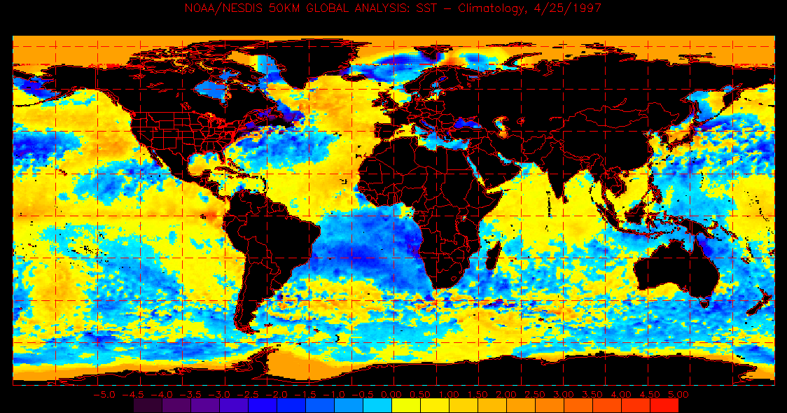
2015
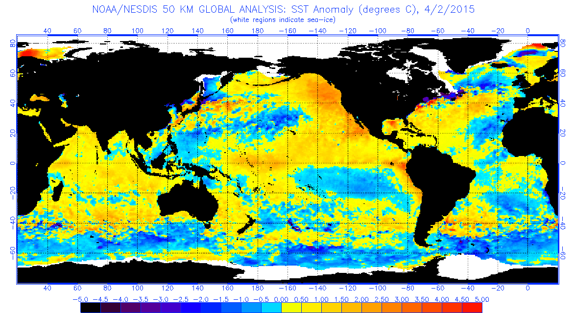
1997
2015
0 likes
REMINDER: My opinions that I, or any other NON Pro-Met in this forum, are unofficial. Please do not take my opinions as an official forecast and warning. I am NOT a meteorologist. Following my forecasts blindly may lead to false alarm, danger and risk if official forecasts from agencies are ignored.
Who is online
Users browsing this forum: dexterlabio and 367 guests