Strong Wave East of Windward Islands-(Is Invest 97L)
Moderator: S2k Moderators
Forum rules

The posts in this forum are NOT official forecasts and should not be used as such. They are just the opinion of the poster and may or may not be backed by sound meteorological data. They are NOT endorsed by any professional institution or STORM2K. For official information, please refer to products from the National Hurricane Center and National Weather Service.
-
Hurricane Andrew

- S2K Supporter

- Posts: 1891
- Age: 27
- Joined: Sun May 23, 2010 2:53 pm
- Location: KS
-
Nikki

- S2K Supporter
- Posts: 291
- Joined: Mon Jun 21, 2010 3:38 pm
- Location: Santa Fe, TX (yes I typed that right TEXAS not New Mexico, I am about 20 miles from Galveston, TX)
Re:
Hurricane Andrew wrote:http://www.storm2k.org/phpbb2/viewtopic.php?f=72&t=108192
Why this link?
0 likes
My name is Nicole and this is what I go by in Storm2k chat! Come chat with us! We have fun in there too!!
A teacher's purpose is not to create students in her own image, but to develop students who can create their own image. ~Author Unknown
Alicia, Allison, Rita, Ike
A teacher's purpose is not to create students in her own image, but to develop students who can create their own image. ~Author Unknown
Alicia, Allison, Rita, Ike
-
Hurricane Andrew
- S2K Supporter
- Posts: 1891
- Age: 27
- Joined: Sun May 23, 2010 2:53 pm
- Location: KS


-
Aric Dunn
- Category 5

- Posts: 21238
- Age: 43
- Joined: Sun Sep 19, 2004 9:58 pm
- Location: Ready for the Chase.
- Contact:
I remember that one. but that never broke from the ITCZ this one is just about free from it already. clearly the dry stable air will probably inhibit develop of this one though.
0 likes
Note: If I make a post that is brief. Please refer back to previous posts for the analysis or reasoning. I do not re-write/qoute what my initial post said each time.
If there is nothing before... then just ask
Space & Atmospheric Physicist, Embry-Riddle Aeronautical University,
I believe the sky is falling...
If there is nothing before... then just ask
Space & Atmospheric Physicist, Embry-Riddle Aeronautical University,
I believe the sky is falling...
-
islandguy246
-
cycloneye

- Admin

- Posts: 149505
- Age: 69
- Joined: Thu Oct 10, 2002 10:54 am
- Location: San Juan, Puerto Rico
Re: Strong Tropical Wave East of Windward Islands-10%
TROPICAL WEATHER OUTLOOK
NWS NATIONAL HURRICANE CENTER MIAMI FL
800 PM EDT WED JUN 27 2012
FOR THE NORTH ATLANTIC...CARIBBEAN SEA AND THE GULF OF MEXICO...
THE NATIONAL HURRICANE CENTER HAS ISSUED THE FINAL ADVISORY ON
POST-TROPICAL CYCLONE DEBBY...LOCATED OVER THE WESTERN ATLANTIC
ABOUT 240 MILES EAST OF ST. AUGUSTINE FLORIDA.
A TROPICAL WAVE LOCATED ABOUT 1500 MILES EAST OF THE SOUTHERN
WINDWARD ISLANDS CONTINUES TO PRODUCE DISORGANIZED SHOWERS
AND A FEW THUNDERSTORMS. ANY DEVELOPMENT SHOULD BE SLOW TO OCCUR AS
IT MOVES WESTWARD AT 10 TO 15 MPH. THIS SYSTEM HAS A LOW
CHANCE...10 PERCENT...OF BECOMING A TROPICAL CYCLONE DURING THE
NEXT 48 HOURS.
ELSEWHERE...TROPICAL CYCLONE FORMATION IS NOT EXPECTED DURING THE
NEXT 48 HOURS.
$$
FORECASTER ROBERTS
0 likes
Visit the Caribbean-Central America Weather Thread where you can find at first post web cams,radars
and observations from Caribbean basin members Click Here
and observations from Caribbean basin members Click Here
-
Gustywind

- Category 5
- Posts: 12334
- Joined: Mon Sep 03, 2007 7:29 am
- Location: Baie-Mahault, GUADELOUPE
000
AXNT20 KNHC 272337
TWDAT
TROPICAL WEATHER DISCUSSION
NWS NATIONAL HURRICANE CENTER MIAMI FL
805 PM EDT WED JUN 27 2012
TROPICAL WEATHER DISCUSSION FOR NORTH AMERICA...CENTRAL
AMERICA...GULF OF MEXICO...CARIBBEAN SEA...NORTHERN SECTIONS OF
SOUTH AMERICA...AND ATLANTIC OCEAN TO THE AFRICAN COAST FROM THE
EQUATOR TO 32N. THE FOLLOWING INFORMATION IS BASED ON SATELLITE
IMAGERY...WEATHER OBSERVATIONS...RADAR...AND METEOROLOGICAL
ANALYSIS.
BASED ON 1800 UTC SURFACE ANALYSIS AND SATELLITE IMAGERY THROUGH
2315 UTC.
...TROPICAL WAVES...
TROPICAL WAVE EXTENDS FROM 15N36W THROUGH A WEAK 1013 MB LOW
NEAR 10N38W TO 7N39W MOVING NNW NEAR 10 KT. WAVE IS EMBEDDED
WITHIN A SURGE OF DEEP LAYER MOISTURE AS DEPICTED ON TOTAL
PRECIPITABLE WATER IMAGERY. WAVE REMAINS TO THE S OF THE SAHARAN
DUST THAT COVERS THE TROPICAL ATLC. SCATTERED SHOWERS/ISOLATED
THUNDERSTORMS ARE WITHIN 45 NM OF 11N BETWEEN 37W-42W.
0 likes
-
Gustywind
- Category 5
- Posts: 12334
- Joined: Mon Sep 03, 2007 7:29 am
- Location: Baie-Mahault, GUADELOUPE
I post this comment related to our daily newspaper to show you how critical the situation is in Guadeloupe and most of the Lesser Antilles! And, you will understand why we hope that this strong twave could really bring copious showers on the butterfly island and adjacent islands in the EC carib. Cycloneye is facing the same in PR: extreme drought, hot hot temperatures!
ENVIRONMENT
Alert the pollution of air
franceantilles.fr27.06.2012
http://www.microsofttranslator.com/bv.a ... 176052.php
The approved association of quality monitoring air Guadeloupe GWADAIR noted today an exceedance of the alert threshold for fine particles in the air. This pollution is caused by significant mists of sand from the Sahara and across currently area Caribbean, associated pollution fuel.
The approved association of quality monitoring air Guadeloupe GWADAIR noted today an exceedance of the alert threshold for fine particles in the air. This pollution is caused by significant mists of sand from the Sahara and across currently area Caribbean, associated pollution fuel.
The result of this concentration of air pollutants, a degraded del air quality index ' order of 10 on a scale of 10. This situation, vigilance is rigorous, especially frail people
who can experience episodes of irritation of the respiratory tract related to this natural phenomenon.
In the meantime the ATMO, prefecture index improved recommends:
-to avoid the physical and sports activities intense because the fines can be
leaders of respiratory gene. They can also cause shortness of breath and
aggravate pre-existing respiratory pathologies.
-to comply with all measures sense likely to limit the non-physical efforts
essential
-to avoid polluting the air by burning in the open air operations...
-focus on carpooling and conduct economic
Light physical activities and outputs outside are not prohibited. The phenomenon persists and can last a few next days. It is recommended to follow the air quality bulletins distributed by GWADAIR.
0 likes

Re: Strong Tropical Wave East of Windward Islands-10%
000
ABNT20 KNHC 280534
TWOAT
TROPICAL WEATHER OUTLOOK
NWS NATIONAL HURRICANE CENTER MIAMI FL
200 AM EDT THU JUN 28 2012
FOR THE NORTH ATLANTIC...CARIBBEAN SEA AND THE GULF OF MEXICO...
A TROPICAL WAVE LOCATED ABOUT 1450 MILES EAST OF THE WINDWARD
ISLANDS CONTINUES TO PRODUCE DISORGANIZED SHOWERS AND A FEW
THUNDERSTORMS. ANY DEVELOPMENT SHOULD BE SLOW TO OCCUR AS IT MOVES
GENERALLY WESTWARD AT 10 TO 15 MPH. THIS SYSTEM HAS A LOW
CHANCE...10 PERCENT...OF BECOMING A TROPICAL CYCLONE DURING THE
NEXT 48 HOURS.
ELSEWHERE...TROPICAL CYCLONE FORMATION IS NOT EXPECTED DURING THE
NEXT 48 HOURS.
$$
FORECASTER BEVEN
0 likes
-
floridasun78
- Category 5
- Posts: 3755
- Joined: Sun May 17, 2009 10:16 pm
- Location: miami fl
Re: Strong Tropical Wave East of Windward Islands-10%
it looking better on sat pic let see how look later today
0 likes
-
Hurricane Alexis

- Category 2

- Posts: 683
- Age: 29
- Joined: Thu Jun 14, 2012 7:59 pm
- Location: Miami,Florida
Re: Strong Tropical Wave East of Windward Islands-10%
[img]
[/img]

[/img]
0 likes
Personal Forecast Disclaimer:
The posts in this forum are NOT official forecast and should not be used as such. They are just the opinion of the poster and may or may not be backed by sound meteorological data. They are NOT endorsed by any professional institution or storm2k.org. For official information, please refer to the NHC and NWS products.
The posts in this forum are NOT official forecast and should not be used as such. They are just the opinion of the poster and may or may not be backed by sound meteorological data. They are NOT endorsed by any professional institution or storm2k.org. For official information, please refer to the NHC and NWS products.
It may be minimal but according to this it finally has some convergence, now let's see if it can increase.

0 likes
I am just an amateur and a "noob" at that so any speculations that I have made are just that, uneducated speculations. Please refer to the NHC for accurate information.
Thank you all for your thoughts, I've loved reading through this community since '06 and finally decided to post more actively.
-JJ
Thank you all for your thoughts, I've loved reading through this community since '06 and finally decided to post more actively.
-JJ

Re: Strong Tropical Wave East of Windward Islands-10%
This has all the earmarks of a classic "pouch".
It is definitely protecting itself from SAL.
MCS's firing in a cluster.
Shear analysis appears to show a minimal anti-cyclone over it.
Well defined and good UL Divergence & LL Convergence.
Absolutely incredible a wave has a structure like this so early in the season.
It is definitely protecting itself from SAL.
MCS's firing in a cluster.
Shear analysis appears to show a minimal anti-cyclone over it.
Well defined and good UL Divergence & LL Convergence.
Absolutely incredible a wave has a structure like this so early in the season.
0 likes
Re: Strong Tropical Wave East of Windward Islands-10%
Analysis is less impressive than before:
000
AXNT20 KNHC 280546
TWDAT
TROPICAL WEATHER DISCUSSION
NWS NATIONAL HURRICANE CENTER MIAMI FL
205 AM EDT THU JUN 28 2012
TROPICAL WEATHER DISCUSSION FOR NORTH AMERICA...CENTRAL
AMERICA...GULF OF MEXICO...CARIBBEAN SEA...NORTHERN SECTIONS OF
SOUTH AMERICA...AND ATLANTIC OCEAN TO THE AFRICAN COAST FROM THE
EQUATOR TO 32N. THE FOLLOWING INFORMATION IS BASED ON SATELLITE
IMAGERY...WEATHER OBSERVATIONS...RADAR...AND METEOROLOGICAL
ANALYSIS.
BASED ON 0000 UTC SURFACE ANALYSIS AND SATELLITE IMAGERY THROUGH
0515 UTC.
...TROPICAL WAVES...
TROPICAL WAVE EXTENDS FROM 08N40W TO 15N37W MOVING W AT 10-15
KT. A WEAK 1015 MB LOW IS ALONG THE WAVE AXIS NEAR 11N. THE WAVE
REMAINS EMBEDDED WITHIN THE ITCZ WITH LOW-LEVEL CYCLONIC FLOW
NOTED BETWEEN 35W-42W APPEARING WEAKER THAN THE PREVIOUS 2-3
DAYS. 700 MB LEVEL STREAMLINES ON THE GLOBAL MODELS ALSO SHOW
SOME WEAKENING HAS OCCURRED OVER THE PAST 24 TO 36 HOURS AS THE
700 MB TROUGHING HAS BROADENED INTO MORE OF AN OPEN TROUGH
BETWEEN 40W-45W. ISOLATED MODERATE CONVECTION IS FROM 11N-13N
BETWEEN 39W-44W...
0 likes
Re: Strong Tropical Wave East of Windward Islands-10%
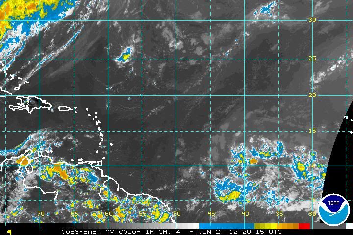
looks fairly healthy this morn. on satellite...anyone feel NHC raises % later?....good morning all...
http://www.ssd.noaa.gov/goes/east/tatl/avn-l.jpg
http://www.ssd.noaa.gov/goes/east/tatl/avn-l.jpg
0 likes
-
wxman57

- Moderator-Pro Met

- Posts: 23175
- Age: 68
- Joined: Sat Jun 21, 2003 8:06 pm
- Location: Houston, TX (southwest)
Re: Strong Tropical Wave East of Windward Islands-10%
No development from this one. It's heading into ever-increasing shear.
0 likes
-
cycloneye
- Admin
- Posts: 149505
- Age: 69
- Joined: Thu Oct 10, 2002 10:54 am
- Location: San Juan, Puerto Rico
Re: Strong Tropical Wave East of Windward Islands-10%
TROPICAL WEATHER OUTLOOK
NWS NATIONAL HURRICANE CENTER MIAMI FL
800 AM EDT THU JUN 28 2012
FOR THE NORTH ATLANTIC...CARIBBEAN SEA AND THE GULF OF MEXICO...
SHOWERS AND THUNDERSTORMS ASSOCIATED WITH A TROPICAL WAVE LOCATED
ABOUT 1350 MILES EAST OF THE WINDWARD ISLANDS HAVE BECOME A LITTLE
MORE CONCENTRATED THIS MORNING. ANY DEVELOPMENT SHOULD BE SLOW TO
OCCUR AS IT MOVES GENERALLY WESTWARD AT 10 TO 15 MPH. THIS SYSTEM
HAS A LOW CHANCE...10 PERCENT...OF BECOMING A TROPICAL CYCLONE
DURING THE NEXT 48 HOURS.
ELSEWHERE...TROPICAL CYCLONE FORMATION IS NOT EXPECTED DURING THE
NEXT 48 HOURS.
$$
FORECASTER KIMBERLAIN
0 likes
Visit the Caribbean-Central America Weather Thread where you can find at first post web cams,radars
and observations from Caribbean basin members Click Here
and observations from Caribbean basin members Click Here
Re: Strong Tropical Wave East of Windward Islands-10%
I say the NHC will go up to either 20% or 30% at the 2 P.M. update. A little off topic.....but the users count went down about 300 since Debby had dissipated. I found that statistically interesting.
0 likes
"People might not get all they work for in this world, but they must certainly work for all they get."- Frederick Douglass
Re: Strong Tropical Wave East of Windward Islands-10%
Oh, and I said 20% or 30% because the newest update mentioned "more concentrated".
0 likes
"People might not get all they work for in this world, but they must certainly work for all they get."- Frederick Douglass
Who is online
Users browsing this forum: Iceresistance and 273 guests