Western Caribbean Area of Interest: (Is INVEST 90L)
Moderator: S2k Moderators
Forum rules

The posts in this forum are NOT official forecasts and should not be used as such. They are just the opinion of the poster and may or may not be backed by sound meteorological data. They are NOT endorsed by any professional institution or STORM2K. For official information, please refer to products from the National Hurricane Center and National Weather Service.
-
floridasun78
- Category 5

- Posts: 3755
- Joined: Sun May 17, 2009 10:16 pm
- Location: miami fl
Re: SW Caribbean Area of Interest
season can wait June 1 we no hurry to early start season because aug we see alot sleepless night like 2017
2 likes
-
CyclonicFury

- Category 5
- Posts: 2032
- Age: 27
- Joined: Sun Jul 02, 2017 12:32 pm
- Location: NC
- Contact:
Re: SW Caribbean Area of Interest
Interesting, GFS sends this into Georgia...

0 likes
NCSU B.S. in Meteorology Class of 2021. Tropical weather blogger at http://www.cyclonicfury.com. My forecasts and thoughts are NOT official, for official forecasts please consult the National Hurricane Center.
-
USTropics
- Professional-Met

- Posts: 2738
- Joined: Sun Aug 12, 2007 3:45 am
- Location: Florida State University
Re: SW Caribbean Area of Interest
00z GFS and ECMWF not too far off from each other in solutions and timing. ECMWF has a bit more of a weaker system, with multiple areas of vorticity along a stretched axis that extends towards the GOM. The end result is a more westward solution compared to the GFS, with the core area of consolidation occurring over FL.
00z GFS:

00z ECMWF:

00z GFS:
00z ECMWF:
1 likes

Re: SW Caribbean Area of Interest
06z run is more west, and weaker.

0 likes
Igor 2010, Sandy 2012, Fay 2014, Gonzalo 2014, Joaquin 2015, Nicole 2016, Humberto 2019, Imelda 2025
I am only a tropical weather enthusiast. My predictions are not official and may or may not be backed by sound meteorological data. For official information, please refer to the NHC and NWS products.
I am only a tropical weather enthusiast. My predictions are not official and may or may not be backed by sound meteorological data. For official information, please refer to the NHC and NWS products.
-
northjaxpro

- S2K Supporter

- Posts: 8900
- Joined: Mon Sep 27, 2010 11:21 am
- Location: Jacksonville, FL
Re: SW Caribbean Area of Interest
06Z GFS has a slow moving, sheared tropical cyclone moving north, directly over the entire Florida peninsula during the Memorial weekend, from hour 192 -228 hours. It does deepen the system to 993 mb over North Florida during hour 210. It then meanders over South Georgia by 234 hours as a 998 mb cyclone.
Potential dangerous flooding event could happen over peninsula if this track.pans out, along with potential of tornadoes.
Potential dangerous flooding event could happen over peninsula if this track.pans out, along with potential of tornadoes.
Last edited by northjaxpro on Fri May 18, 2018 6:09 am, edited 2 times in total.
0 likes
NEVER, EVER SAY NEVER in the tropics and weather in general, and most importantly, with life itself!!
________________________________________________________________________________________
Fay 2008 Beryl 2012 Debby 2012 Colin 2016 Hermine 2016 Julia 2016 Matthew 2016 Irma 2017 Dorian 2019
________________________________________________________________________________________
Fay 2008 Beryl 2012 Debby 2012 Colin 2016 Hermine 2016 Julia 2016 Matthew 2016 Irma 2017 Dorian 2019
-
Dean4Storms
- S2K Supporter
- Posts: 6358
- Age: 63
- Joined: Sun Aug 31, 2003 1:01 pm
- Location: Miramar Bch. FL
Re: SW Caribbean Area of Interest
0z ECM EPS still at 30% chance of TS between 25th and 27th in the Eastern GOM. The Ensembles seem to be further westward with the North tracking Low than the 00z ECM OP.
0 likes
-
HURRICANELONNY
- Category 5
- Posts: 1392
- Joined: Wed May 07, 2003 6:48 am
- Location: HOLLYWOOD.FL
Re: SW Caribbean Area of Interest
Climo says west. I've seen this a 100 times. By the time we get within 96 hrs. Whatever forms. Models will trend west. Just my opinion of what models trend as we get closer in hours. 
0 likes
hurricanelonny
-
northjaxpro
- S2K Supporter
- Posts: 8900
- Joined: Mon Sep 27, 2010 11:21 am
- Location: Jacksonville, FL
Re: SW Caribbean Area of Interest
0 likes
NEVER, EVER SAY NEVER in the tropics and weather in general, and most importantly, with life itself!!
________________________________________________________________________________________
Fay 2008 Beryl 2012 Debby 2012 Colin 2016 Hermine 2016 Julia 2016 Matthew 2016 Irma 2017 Dorian 2019
________________________________________________________________________________________
Fay 2008 Beryl 2012 Debby 2012 Colin 2016 Hermine 2016 Julia 2016 Matthew 2016 Irma 2017 Dorian 2019
-
AJC3

- Admin

- Posts: 4153
- Age: 62
- Joined: Tue Aug 31, 2004 7:04 pm
- Location: Ballston Spa, New York
- Contact:
Re: SW Caribbean Area of Interest
HURRICANELONNY wrote:Climo says west. I've seen this a 100 times. By the time we get within 96 hrs. Whatever forms. Models will trend west. Just my opinion of what models trend as we get closer in hours.
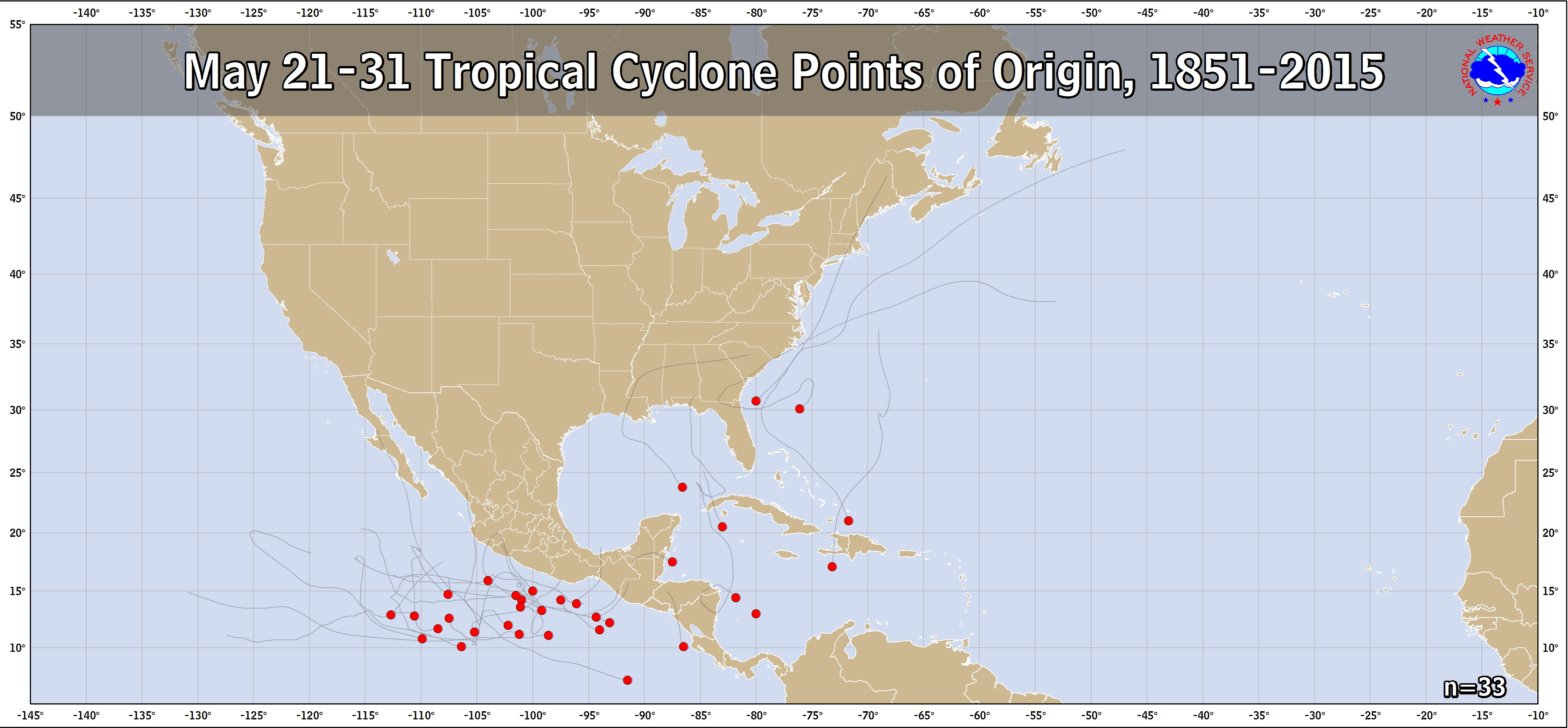
Keep in mind that there isn't a whole lot of May 21-31 genesis climo to go by here - only five systems of at least TS strength are known to have formed in the WCARIB and SE GOMEX (between 13-23N and 80-88W) during that 10 day period since 1851. So most (if not all) of your '100 times' fell much later in the season, when climatological tracks do go farther west.
5 likes
-
srainhoutx

- S2K Supporter
- Posts: 6919
- Age: 68
- Joined: Sun Jan 14, 2007 11:34 am
- Location: Haywood County, NC
- Contact:
Re: SW Caribbean Area of Interest
The 00Z TC Genesis Probabilities via the Ensembles increased to 50% chance of TC genesis in the NW Caribbean Sea within 120 hours.
3 likes
Carla/Alicia/Jerry(In The Eye)/Michelle/Charley/Ivan/Dennis/Katrina/Rita/Wilma/Ike/Harvey
Member: National Weather Association
Wx Infinity Forums
http://wxinfinity.com/index.php
Facebook.com/WeatherInfinity
Twitter @WeatherInfinity
Member: National Weather Association
Wx Infinity Forums
http://wxinfinity.com/index.php
Facebook.com/WeatherInfinity
Twitter @WeatherInfinity
-
Dean4Storms
- S2K Supporter
- Posts: 6358
- Age: 63
- Joined: Sun Aug 31, 2003 1:01 pm
- Location: Miramar Bch. FL
Re: SW Caribbean Area of Interest
srainhoutx wrote:The 00Z TC Genesis Probabilities via the Ensembles increased to 50% chance of TC genesis in the NW Caribbean Sea within 120 hours.
This the GFS Ensembles?
0 likes
-
TheStormExpert
Re: SW Caribbean Area of Interest
I wouldn’t expect more than a weak sheared messy TS coming from this with multiple vortices competing for one.
0 likes
-
gatorcane

- S2K Supporter
- Posts: 23708
- Age: 48
- Joined: Sun Mar 13, 2005 3:54 pm
- Location: Boca Raton, FL
Re: SW Caribbean Area of Interest
AJC3 wrote:HURRICANELONNY wrote:Climo says west. I've seen this a 100 times. By the time we get within 96 hrs. Whatever forms. Models will trend west. Just my opinion of what models trend as we get closer in hours.
Keep in mind that there isn't a whole lot of May 21-31 genesis climo to go by here - only five systems of at least TS strength are known to have formed in the WCARIB and SE GOMEX (between 13-23N and 80-88W) during that 10 day period since 1851. So most (if not all) of your '100 times' fell much later in the season, when climatological tracks do go farther west.
https://www.nhc.noaa.gov/climo/images/may_21_31.png
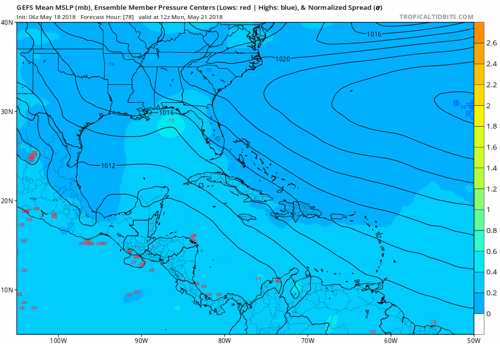
The models are definitely detecting some kind of pattern that would turn the system NNE or NE once in the NW Caribbean. For example, the latest 06Z GEFS animation from hours 78 to 192 shows this well, but, we are still far enough out that I agree they can shift back into the Gulf:
0 likes
-
srainhoutx
- S2K Supporter
- Posts: 6919
- Age: 68
- Joined: Sun Jan 14, 2007 11:34 am
- Location: Haywood County, NC
- Contact:
Re: SW Caribbean Area of Interest
Dean4Storms wrote:srainhoutx wrote:The 00Z TC Genesis Probabilities via the Ensembles increased to 50% chance of TC genesis in the NW Caribbean Sea within 120 hours.
This the GFS Ensembles?
NCEP/ECMWF/CMC suite of ensembles.
0 likes
Carla/Alicia/Jerry(In The Eye)/Michelle/Charley/Ivan/Dennis/Katrina/Rita/Wilma/Ike/Harvey
Member: National Weather Association
Wx Infinity Forums
http://wxinfinity.com/index.php
Facebook.com/WeatherInfinity
Twitter @WeatherInfinity
Member: National Weather Association
Wx Infinity Forums
http://wxinfinity.com/index.php
Facebook.com/WeatherInfinity
Twitter @WeatherInfinity
-
gatorcane
- S2K Supporter
- Posts: 23708
- Age: 48
- Joined: Sun Mar 13, 2005 3:54 pm
- Location: Boca Raton, FL
Re: SW Caribbean Area of Interest
Convection is increasing in the SW Caribbean albeit sheared still:
http://rammb.cira.colostate.edu/ramsdis ... display=12
http://rammb.cira.colostate.edu/ramsdis ... display=12
1 likes
-
wxman57

- Moderator-Pro Met

- Posts: 23172
- Age: 68
- Joined: Sat Jun 21, 2003 8:06 pm
- Location: Houston, TX (southwest)
Re: SW Caribbean Area of Interest
00Z EC ensembles were indicating a western Florida Panhandle hit. Interesting that the 00Z operational EC was to the far right of all ensemble members. GFS ensembles are focused on SW Florida Peninsula, same as operational.
1 likes
-
WeatherEmperor
- S2K Supporter
- Posts: 4806
- Age: 42
- Joined: Thu Sep 04, 2003 2:54 pm
- Location: South Florida
Re: SW Caribbean Area of Interest
wxman57 wrote:00Z EC ensembles were indicating a western Florida Panhandle hit. Interesting that the 00Z operational EC was to the far right of all ensemble members. GFS ensembles are focused on SW Florida Peninsula, same as operational.
Sorry for the dumb question, but do you see this becoming more than a sloppy/sheared TS?
0 likes
-
wxman57
- Moderator-Pro Met
- Posts: 23172
- Age: 68
- Joined: Sat Jun 21, 2003 8:06 pm
- Location: Houston, TX (southwest)
Re: SW Caribbean Area of Interest
WeatherEmperor wrote:wxman57 wrote:00Z EC ensembles were indicating a western Florida Panhandle hit. Interesting that the 00Z operational EC was to the far right of all ensemble members. GFS ensembles are focused on SW Florida Peninsula, same as operational.
Sorry for the dumb question, but do you see this becoming more than a sloppy/sheared TS?
For now, I'd go with a "sloppy" TS, but it's too far out to be very confident in what will eventually happen.
0 likes
Re: SW Caribbean Area of Interest
MUCH weaker so far. Not even a closed low any longer on the GFS
Canadian still has the EPAC TC with now only a disorganized low that is too weak to be classified in the Gulf
12Z models coming in weaker. Even ICON was slightly weaker
Canadian still has the EPAC TC with now only a disorganized low that is too weak to be classified in the Gulf
12Z models coming in weaker. Even ICON was slightly weaker
0 likes
-
TheStormExpert
Re: SW Caribbean Area of Interest
Alyono wrote:MUCH weaker so far. Not even a closed low any longer on the GFS
Canadian still has the EPAC TC with now only a disorganized low that is too weak to be classified in the Gulf
12Z models coming in weaker. Even ICON was slightly weaker
The GFS was likely overdoing it (as usual) and is now playing catchup. Wouldn't be surprised if in the end this doesn't even get classified a TC.
1 likes
Who is online
Users browsing this forum: ljmac75 and 117 guests