Tropical Wave in the East-Central Caribbean (Is Invest 92L)
Moderator: S2k Moderators
Forum rules

The posts in this forum are NOT official forecasts and should not be used as such. They are just the opinion of the poster and may or may not be backed by sound meteorological data. They are NOT endorsed by any professional institution or STORM2K. For official information, please refer to products from the National Hurricane Center and National Weather Service.
-
Hurricaneman

- Category 5

- Posts: 7404
- Age: 45
- Joined: Tue Aug 31, 2004 3:24 pm
- Location: central florida
Re: Tropical Wave East of the Lesser Antilles
The CMC is showing an intensifying storm heading slowly north at 204hrs through the Yucatan Channel
0 likes
Re: Tropical Wave East of the Lesser Antilles
Hurricaneman wrote:The CMC is showing an intensifying storm heading slowly north at 204hrs through the Yucatan Channel
0Z CMC at 240/cartoonland fwiw:

0 likes
Personal Forecast Disclaimer:
The posts in this forum are NOT official forecasts and should not be used as such. They are just the opinion of the poster and may or may not be backed by sound meteorological data. They are NOT endorsed by any professional institution or storm2k.org. For official information, please refer to the NHC and NWS products.
The posts in this forum are NOT official forecasts and should not be used as such. They are just the opinion of the poster and may or may not be backed by sound meteorological data. They are NOT endorsed by any professional institution or storm2k.org. For official information, please refer to the NHC and NWS products.
-
SFLcane

- S2K Supporter

- Posts: 10281
- Age: 48
- Joined: Sat Jun 05, 2010 1:44 pm
- Location: Lake Worth Florida
Re: Tropical Wave East of the Lesser Antilles
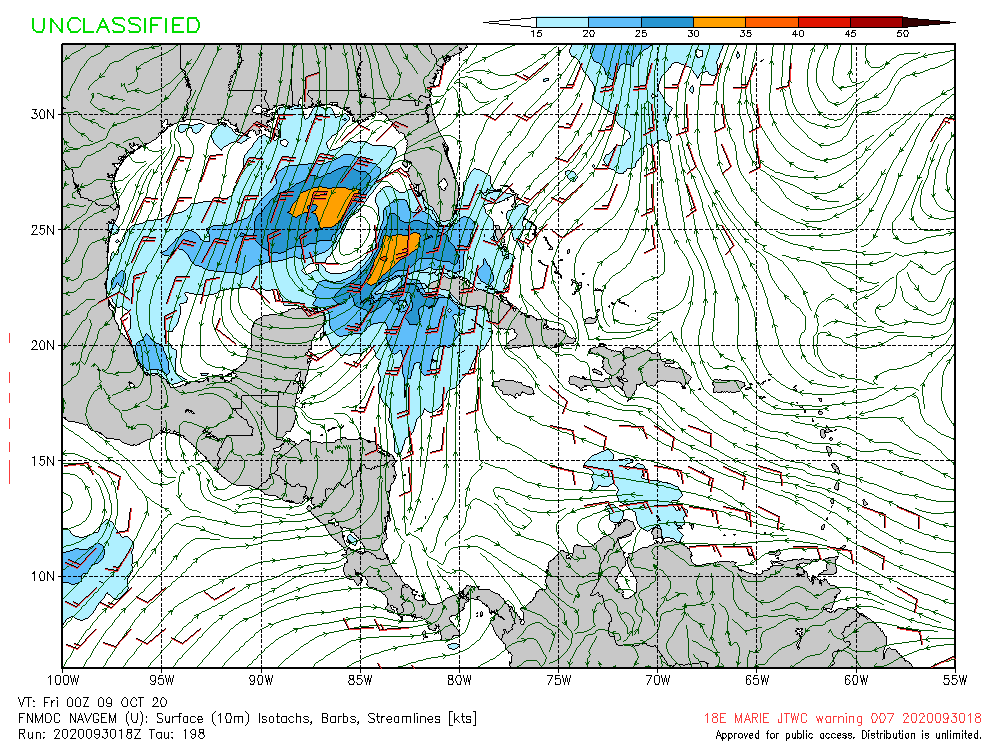
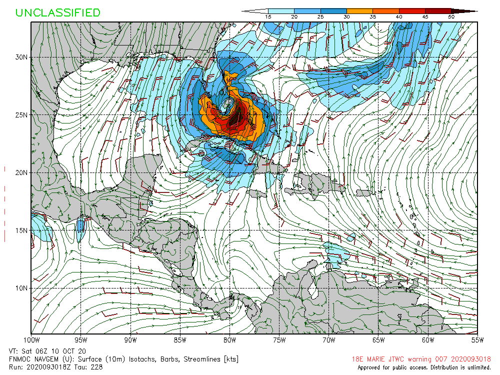
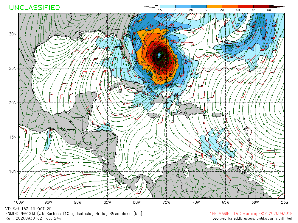
gatorcane wrote:18Z NAVGEM moves this into the SE GOM then it turns E to ENE and moves over South Florida while rapidly intensifying over the Bahamas
https://i.postimg.cc/yY2F8fJW/nvg10-sfc10m-198-go-mex.gif
https://i.postimg.cc/brDhYYMG/nvg10-sfc10m-228-go-mex.gif
https://i.postimg.cc/YqrPxC8Q/nvg10-sfc10m-240-go-mex.gif
Thankfully it’s a garbage model showing this.
0 likes
-
jlauderdal
- S2K Supporter
- Posts: 7240
- Joined: Wed May 19, 2004 5:46 am
- Location: NE Fort Lauderdale
- Contact:
Re: Tropical Wave East of the Lesser Antilles
SFLcane wrote:gatorcane wrote:18Z NAVGEM moves this into the SE GOM then it turns E to ENE and moves over South Florida while rapidly intensifying over the Bahamas
https://i.postimg.cc/yY2F8fJW/nvg10-sfc10m-198-go-mex.gif
https://i.postimg.cc/brDhYYMG/nvg10-sfc10m-228-go-mex.gif
https://i.postimg.cc/YqrPxC8Q/nvg10-sfc10m-240-go-mex.gif
Thankfully it’s a garbage model showing this.
South Florida is the magnet, navgem is the iron
1 likes
-
cycloneye

- Admin

- Posts: 149442
- Age: 69
- Joined: Thu Oct 10, 2002 10:54 am
- Location: San Juan, Puerto Rico
Re: Tropical Wave East of the Lesser Antilles
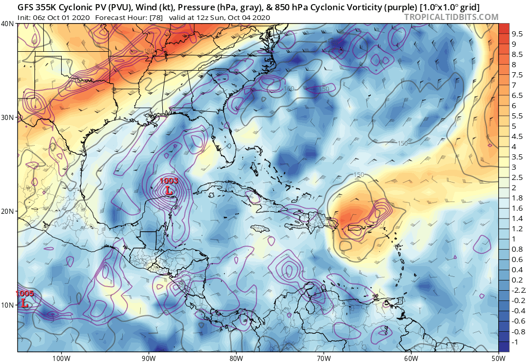
2. Another tropical wave located just east of the Lesser Antilles is
also producing a large area of disorganized showers and
thunderstorms. This wave is forecast to move westward at 15 to 20
mph during the next several days, and environmental conditions
could become a little more conducive for development when the system
is over the central or western Caribbean Sea early next week.
* Formation chance through 48 hours...low...near 0 percent.
* Formation chance through 5 days...low...20 percent.
0 likes
Visit the Caribbean-Central America Weather Thread where you can find at first post web cams,radars
and observations from Caribbean basin members Click Here
and observations from Caribbean basin members Click Here
-
SFLcane
- S2K Supporter
- Posts: 10281
- Age: 48
- Joined: Sat Jun 05, 2010 1:44 pm
- Location: Lake Worth Florida
Re: Tropical Wave East of the Lesser Antilles
Yea gfs and gfs/p don’t really do much with this wave anymore atleast that’s the trend last 24rs or so.
0 likes
-
Dean4Storms
- S2K Supporter
- Posts: 6358
- Age: 63
- Joined: Sun Aug 31, 2003 1:01 pm
- Location: Miramar Bch. FL
Re: Tropical Wave East of the Lesser Antilles
Would expect this to be an Invest at anytime today.
0 likes
-
AutoPenalti
- Category 5
- Posts: 4091
- Age: 29
- Joined: Mon Aug 17, 2015 4:16 pm
- Location: Ft. Lauderdale, Florida
Re: Tropical Wave East of the Lesser Antilles
SFLcane wrote:Yea gfs and gfs/p don’t really do much with this wave anymore atleast that’s the trend last 24rs or so.
What a mess with these models...
3 likes
The posts in this forum are NOT official forecasts and should not be used as such. They are just the opinion of the poster and may or may not be backed by sound meteorological data. They are NOT endorsed by any professional institution or STORM2K. For official information, please refer to products from the NHC and NWS.
Model Runs Cheat Sheet:
GFS (5:30 AM/PM, 11:30 AM/PM)
HWRF, GFDL, UKMET, NAVGEM (6:30-8:00 AM/PM, 12:30-2:00 AM/PM)
ECMWF (1:45 AM/PM)
TCVN is a weighted averaged
-
SFLcane
- S2K Supporter
- Posts: 10281
- Age: 48
- Joined: Sat Jun 05, 2010 1:44 pm
- Location: Lake Worth Florida
Re: Tropical Wave East of the Lesser Antilles
Dean4Storms wrote:Would expect this to be an Invest at anytime today.
Possibly but doubt it it’s got a date with a pv/streamer which might be the reason for dwindling model support.
2 likes


Re: Tropical Wave East of the Lesser Antilles
gatorcane wrote:18Z NAVGEM moves this into the SE GOM then it turns E to ENE and moves over South Florida while rapidly intensifying over the Bahamas
The GFS also has one run about three days ago that showed an expansive hurricane exploding out over the Bahamas going NE.
0 likes
FAA ATP
Belize UAS Operator
Belize UAS Operator
-
SFLcane
- S2K Supporter
- Posts: 10281
- Age: 48
- Joined: Sat Jun 05, 2010 1:44 pm
- Location: Lake Worth Florida
Re: Tropical Wave East of the Lesser Antilles
gatorcane wrote:18Z NAVGEM moves this into the SE GOM then it turns E to ENE and moves over South Florida while rapidly intensifying over the Bahamas
https://i.postimg.cc/yY2F8fJW/nvg10-sfc10m-198-go-mex.gif
https://i.postimg.cc/brDhYYMG/nvg10-sfc10m-228-go-mex.gif
https://i.postimg.cc/YqrPxC8Q/nvg10-sfc10m-240-go-mex.gif
Just for fun... nogaps doubled down.
Edit: wait what it’s the first wave takes it up towards the gulfcoast then swings it back south into SFL.

0 likes
-
toad strangler

- S2K Supporter
- Posts: 4546
- Joined: Sun Jul 28, 2013 3:09 pm
- Location: Earth
- Contact:
Re: Tropical Wave East of the Lesser Antilles
aHHHHH if I had a nickle for every NAVY run I saw slam the FL peninsula 
0 likes
My Weather Station
https://www.wunderground.com/dashboard/pws/KFLPORTS603
https://www.wunderground.com/dashboard/pws/KFLPORTS603
-
SFLcane
- S2K Supporter
- Posts: 10281
- Age: 48
- Joined: Sat Jun 05, 2010 1:44 pm
- Location: Lake Worth Florida
Re: Tropical Wave East of the Lesser Antilles
toad strangler wrote:aHHHHH if I had a nickle for every NAVY run I saw slam the FL peninsula
Not even a physical solution lol.
0 likes
-
jlauderdal
- S2K Supporter
- Posts: 7240
- Joined: Wed May 19, 2004 5:46 am
- Location: NE Fort Lauderdale
- Contact:
Re: Tropical Wave East of the Lesser Antilles
how about the gfs and its offsprings?toad strangler wrote:aHHHHH if I had a nickle for every NAVY run I saw slam the FL peninsula
0 likes

Re: Tropical Wave East of the Lesser Antilles
SFLcane wrote:Maybe this will get tagged sometime today
Unlikely, usually they wait for the 5 day development probabilities to get into the medium/high range.
0 likes
-
SFLcane
- S2K Supporter
- Posts: 10281
- Age: 48
- Joined: Sat Jun 05, 2010 1:44 pm
- Location: Lake Worth Florida
Re: Tropical Wave East of the Lesser Antilles
us89 wrote:SFLcane wrote:Maybe this will get tagged sometime today
Unlikely, usually they wait for the 5 day development probabilities to get into the medium/high range.
Yep, which is now close to 0 as models have lost interest.
That ULL is going split it in two.
0 likes

Re: Tropical Wave East of the Lesser Antilles
SFLcane wrote:us89 wrote:SFLcane wrote:Maybe this will get tagged sometime today
Unlikely, usually they wait for the 5 day development probabilities to get into the medium/high range.
Yep, which is now close to 0 as models have lost interest.
That ULL is going split it in two.
That’s probably why the GFS-Para shows its vorticity going north of the GAs and into the Bahamas. Could be something to watch for them and the SEUS instead of the Caribbean.
0 likes
Irene '11 Sandy '12 Hermine '16 5/15/2018 Derecho Fay '20 Isaias '20 Elsa '21 Henri '21 Ida '21
I am only a meteorology enthusiast who knows a decent amount about tropical cyclones. Look to the professional mets, the NHC, or your local weather office for the best information.
I am only a meteorology enthusiast who knows a decent amount about tropical cyclones. Look to the professional mets, the NHC, or your local weather office for the best information.
-
SFLcane
- S2K Supporter
- Posts: 10281
- Age: 48
- Joined: Sat Jun 05, 2010 1:44 pm
- Location: Lake Worth Florida
Re: Tropical Wave East of the Lesser Antilles
CMC and ICON like this wave near the Yucatán then potentially hooking right towards FL.
0 likes
-
SouthFLTropics

- Category 5
- Posts: 4258
- Age: 50
- Joined: Thu Aug 14, 2003 8:04 am
- Location: Port St. Lucie, Florida
Re: Tropical Wave East of the Lesser Antilles
12z GEFS is more enthusiastic than the 06z was.

0 likes
Fourth Generation Florida Native
Personal Storm History: David 79, Andrew 92, Erin 95, Floyd 99, Irene 99, Frances 04, Jeanne 04, Wilma 05, Matthew 16, Irma 17, Ian 22, Nicole 22, Milton 24
Personal Storm History: David 79, Andrew 92, Erin 95, Floyd 99, Irene 99, Frances 04, Jeanne 04, Wilma 05, Matthew 16, Irma 17, Ian 22, Nicole 22, Milton 24