2017 indicators: SST's / MSLP / SAL / Steering / Instability

This is the general tropical discussion area. Anyone can take their shot at predicting a storms path.

Moderator: S2k Moderators

Forum rules

The posts in this forum are NOT official forecasts and should not be used as such. They are just the opinion of the poster and may or may not be backed by sound meteorological data. They are NOT endorsed by any professional institution or STORM2K. For official information, please refer to products from the National Hurricane Center and National Weather Service.

Help Support Storm2K
Message
Author
User avatar
chaser1
S2K Supporter
S2K Supporter
Posts: 4749
Age: 63
Joined: Sat Oct 15, 2005 5:59 pm
Location: Longwood, Fl

Re: 2017 indicators: SST's / MSLP / SAL / Steering / Instability

#661 Postby chaser1 » Tue Jul 11, 2017 8:17 am

NDG wrote:After all the fake news by the models of a potential busy July over the Atlantic is time to realize that conditions are not there yet over the basin, is just a typical July, we are going to have to wait until August, the strong waves that come out of Africa will continue to struggle with the SAL over the Atlantic MDR and then windshear over the Caribbean, which by the way it has continued despite the CFSv2 persistently forecasting it to come down.
Time to get entertained in the EPAC.


You thnk? Any Poker Players in the house? How 'bout "Jack's or Better" :tailgate:

"I'll bet 4 Millibars on my pair of Jacks (Depression's) in the hole, prior to August 1" Any takers? :cheesy:
2 likes   
Personal Forecast Disclaimer:
The posts in this forum are NOT official forecast and should not be used as such. They are just the opinion of the poster and may or may not be backed by sound meteorological data. They are NOT endorsed by any professional institution or storm2k.org. For official information, please refer to the NHC and NWS products.


WeatherHoon
Tropical Storm
Tropical Storm
Posts: 131
Joined: Sat Oct 01, 2016 6:12 am

Re: 2017 indicators: SST's / MSLP / SAL / Steering / Instability

#662 Postby WeatherHoon » Tue Jul 11, 2017 10:34 am

0 likes   

User avatar
TheStormExpert
Category 5
Category 5
Posts: 8487
Age: 30
Joined: Wed Feb 16, 2011 5:38 pm
Location: Palm Beach Gardens, FL

Re: 2017 indicators: SST's / MSLP / SAL / Steering / Instability

#663 Postby TheStormExpert » Tue Jul 11, 2017 1:38 pm


Is this for a certain short-term period or long-term?
0 likes   
The following post is NOT an official forecast and should not be used as such. It is just the opinion of the poster and may or may not be backed by sound meteorological data. It is NOT endorsed by storm2k.org.

RL3AO
Moderator-Pro Met
Moderator-Pro Met
Posts: 16308
Joined: Thu Jun 14, 2007 10:03 pm
Location: NC

Re: 2017 indicators: SST's / MSLP / SAL / Steering / Instability

#664 Postby RL3AO » Tue Jul 11, 2017 1:51 pm

TheStormExpert wrote:Is this for a certain short-term period or long-term?


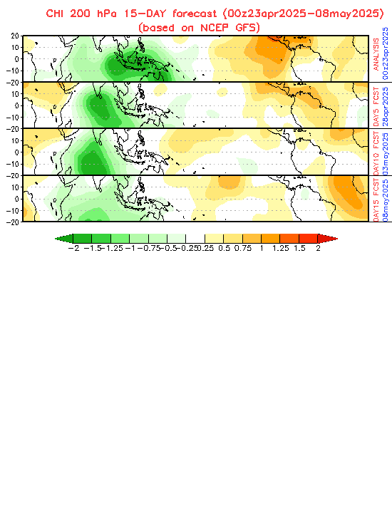
While this is the low-frequency band and not the MJO, I suspect much of it has to do with the very significant amplification of the MJO that the EPS has. No other models show anywhere near as strong of a MJO signal.
0 likes   

User avatar
TheStormExpert
Category 5
Category 5
Posts: 8487
Age: 30
Joined: Wed Feb 16, 2011 5:38 pm
Location: Palm Beach Gardens, FL

Re: 2017 indicators: SST's / MSLP / SAL / Steering / Instability

#665 Postby TheStormExpert » Tue Jul 11, 2017 1:52 pm

RL3AO wrote:
TheStormExpert wrote:Is this for a certain short-term period or long-term?


While this is the low-frequency band and not the MJO, I suspect much of it has to do with the very significant amplification of the MJO that the EPS has. No other models show anywhere near as strong of a MJO signal.

But will this affect how active or inactive the rest of Atlantic season is?
0 likes   
The following post is NOT an official forecast and should not be used as such. It is just the opinion of the poster and may or may not be backed by sound meteorological data. It is NOT endorsed by storm2k.org.

RL3AO
Moderator-Pro Met
Moderator-Pro Met
Posts: 16308
Joined: Thu Jun 14, 2007 10:03 pm
Location: NC

Re: 2017 indicators: SST's / MSLP / SAL / Steering / Instability

#666 Postby RL3AO » Tue Jul 11, 2017 2:02 pm

TheStormExpert wrote:
RL3AO wrote:
TheStormExpert wrote:Is this for a certain short-term period or long-term?


While this is the low-frequency band and not the MJO, I suspect much of it has to do with the very significant amplification of the MJO that the EPS has. No other models show anywhere near as strong of a MJO signal.

But will this affect how active or inactive the rest of Atlantic season is?


It would impact the rest of July. Can't tell much beyond that.
0 likes   

RL3AO
Moderator-Pro Met
Moderator-Pro Met
Posts: 16308
Joined: Thu Jun 14, 2007 10:03 pm
Location: NC

Re: 2017 indicators: SST's / MSLP / SAL / Steering / Instability

#667 Postby RL3AO » Tue Jul 11, 2017 2:02 pm

TheStormExpert wrote:
RL3AO wrote:
TheStormExpert wrote:Is this for a certain short-term period or long-term?


While this is the low-frequency band and not the MJO, I suspect much of it has to do with the very significant amplification of the MJO that the EPS has. No other models show anywhere near as strong of a MJO signal.

But will this affect how active or inactive the rest of Atlantic season is?


It would impact the rest of July. Can't tell much beyond that.
1 likes   

User avatar
gatorcane
S2K Supporter
S2K Supporter
Posts: 23499
Age: 46
Joined: Sun Mar 13, 2005 3:54 pm
Location: Boca Raton, FL

Re: 2017 indicators: SST's / MSLP / SAL / Steering / Instability

#668 Postby gatorcane » Tue Jul 11, 2017 2:49 pm

Maybe better MJO phase for Atlantic starting around 10 days from now?

Image
0 likes   

RL3AO
Moderator-Pro Met
Moderator-Pro Met
Posts: 16308
Joined: Thu Jun 14, 2007 10:03 pm
Location: NC

Re: 2017 indicators: SST's / MSLP / SAL / Steering / Instability

#669 Postby RL3AO » Tue Jul 11, 2017 3:03 pm

gatorcane wrote:Maybe better MJO phase for Atlantic starting around 10 days from now?


Maybe, but you're getting vastly different forecasts from the GFS vs Euro vs CFS.

CFS
Image

GFS
Image

Euro
Image
0 likes   

Ntxw
Storm2k Moderator
Storm2k Moderator
Posts: 21565
Joined: Wed Oct 21, 2009 6:34 pm
Location: DFW, Texas

Re: 2017 indicators: SST's / MSLP / SAL / Steering / Instability

#670 Postby Ntxw » Tue Jul 11, 2017 3:16 pm

Previously mentioned in posts #643 and 655 one page before none of this is really unexpected. Its been well seen conditions are not ideal for a few weeks of this month via subsidence and climo. Its nothing unprecedented. It will take a little time for rising air to work its way back.
0 likes   
The above post and any post by Ntxw is NOT an official forecast and should not be used as such. It is just the opinion of the poster and may or may not be backed by sound meteorological data. It is NOT endorsed by any professional institution including Storm2k. For official information, please refer to NWS products.

  Help support Storm2K!
Help Support Storm2K

Weather150
Tropical Storm
Tropical Storm
Posts: 190
Joined: Fri Jul 07, 2017 7:46 pm

Re: 2017 indicators: SST's / MSLP / SAL / Steering / Instability

#671 Postby Weather150 » Tue Jul 11, 2017 5:02 pm

Does anyone know what date Pouch tracking starts this year? I know it is around the middle of July.
0 likes   

User avatar
Hammy
Category 5
Category 5
Posts: 5594
Age: 40
Joined: Fri May 25, 2012 5:25 pm
Contact:

Re: 2017 indicators: SST's / MSLP / SAL / Steering / Instability

#672 Postby Hammy » Tue Jul 11, 2017 8:25 pm

I'm still not confident enough to make a forecast on the season yet as there are too many mixed signals. I was hoping for July to give me some idea but that doesn't seem likely at this point. I will say the MDR activity to this point is interesting, even with one being only a depression. In the last four decades only 1979, 2003, and 2005 had two MRD systems (depressions included) before the 20th, and in fact most had none.
0 likes   
The above post is not official and should not be used as such. It is the opinion of the poster and may or may not be backed by sound meteorological data. It is not endorsed by any professional institution or storm2k.org. For official information, please refer to the NHC and NWS products.

User avatar
SFLcane
S2K Supporter
S2K Supporter
Posts: 9626
Age: 46
Joined: Sat Jun 05, 2010 1:44 pm
Location: Lake Worth Florida

Re: 2017 indicators: SST's / MSLP / SAL / Steering / Instability

#673 Postby SFLcane » Tue Jul 11, 2017 9:51 pm

0 likes   

CrazyC83
Professional-Met
Professional-Met
Posts: 33398
Joined: Tue Mar 07, 2006 11:57 pm
Location: Deep South, for the first time!

Re: 2017 indicators: SST's / MSLP / SAL / Steering / Instability

#674 Postby CrazyC83 » Tue Jul 11, 2017 10:30 pm

The steering patterns seem reminiscent of 1996 and 2003 in my view.
1 likes   

User avatar
Hurricaneman
Category 5
Category 5
Posts: 7284
Age: 43
Joined: Tue Aug 31, 2004 3:24 pm
Location: central florida

Re: 2017 indicators: SST's / MSLP / SAL / Steering / Instability

#675 Postby Hurricaneman » Tue Jul 11, 2017 11:55 pm

CrazyC83 wrote:The steering patterns seem reminiscent of 1996 and 2003 in my view.

Actually those are good track analogs along with maybe 2004 depending on the reach and orientation and strength so we'll see
1 likes   

User avatar
ROCK
Category 5
Category 5
Posts: 9254
Age: 53
Joined: Tue Aug 17, 2004 7:30 am
Location: Kemah, Texas

Re: 2017 indicators: SST's / MSLP / SAL / Steering / Instability

#676 Postby ROCK » Wed Jul 12, 2017 1:05 am

CrazyC83 wrote:The steering patterns seem reminiscent of 1996 and 2003 in my view.


They are for July.. :lol: it's not August and we have seen what SAL has done this month so far.

We need to wait for it. I think we got spoiled with this early season quagmire of crap. It will start in a few weeks..wait for it.. :wink:
0 likes   

User avatar
cycloneye
Admin
Admin
Posts: 139593
Age: 67
Joined: Thu Oct 10, 2002 10:54 am
Location: San Juan, Puerto Rico

Re: 2017 indicators: SST's / MSLP / SAL / Steering / Instability

#677 Postby cycloneye » Wed Jul 12, 2017 10:31 am

@MJVentrice
After an impressive June, African easterly wave activity will reduce in July as the intraseasonal state shifts to unfavorable o/Africa


Image

 https://twitter.com/MJVentrice/status/885157426693111809


0 likes   
Visit the Caribbean-Central America Weather Thread where you can find at first post web cams,radars
and observations from Caribbean basin members Click Here

User avatar
Hurricane Andrew
S2K Supporter
S2K Supporter
Posts: 1891
Age: 25
Joined: Sun May 23, 2010 2:53 pm
Location: KS

Re: 2017 indicators: SST's / MSLP / SAL / Steering / Instability

#678 Postby Hurricane Andrew » Wed Jul 12, 2017 10:40 am

I wonder how long that reduced phase will last. If the wave train, MJO, and WWB(?) both kick into high gear at the same time, things could get interesting.
0 likes   

The Enthusiast
NREMT-AEMT, WX nerd

Irene '11, Sandy '12, Irma '17 (SAR)

"Hard to think we were born to live this way..." -Wage War

Weather150
Tropical Storm
Tropical Storm
Posts: 190
Joined: Fri Jul 07, 2017 7:46 pm

Re: 2017 indicators: SST's / MSLP / SAL / Steering / Instability

#679 Postby Weather150 » Wed Jul 12, 2017 12:03 pm

Image
If this is to be right, the MJO should be back in the Atlantic by very late July.
0 likes   

AutoPenalti
Category 5
Category 5
Posts: 3950
Age: 27
Joined: Mon Aug 17, 2015 4:16 pm
Location: Ft. Lauderdale, Florida

Re: 2017 indicators: SST's / MSLP / SAL / Steering / Instability

#680 Postby AutoPenalti » Wed Jul 12, 2017 1:18 pm

Hammy wrote:I'm still not confident enough to make a forecast on the season yet as there are too many mixed signals. I was hoping for July to give me some idea but that doesn't seem likely at this point. I will say the MDR activity to this point is interesting, even with one being only a depression. In the last four decades only 1979, 2003, and 2005 had two MRD systems (depressions included) before the 20th, and in fact most had none.


So what do you think Hammy? Quiet season for the ATL and a hyper active one in the EPAC with a neutral el-niño?
:lol:
0 likes   
The posts in this forum are NOT official forecasts and should not be used as such. They are just the opinion of the poster and may or may not be backed by sound meteorological data. They are NOT endorsed by any professional institution or STORM2K. For official information, please refer to products from the NHC and NWS.


Model Runs Cheat Sheet:
GFS (5:30 AM/PM, 11:30 AM/PM)
HWRF, GFDL, UKMET, NAVGEM (6:30-8:00 AM/PM, 12:30-2:00 AM/PM)
ECMWF (1:45 AM/PM)

TCVN
is a weighted averaged


Return to “Talkin' Tropics”

Who is online

Users browsing this forum: Craters, duilaslol, gatorcane, Hurricane2022, Kip, South Texas Storms, Sps123, TheWisestofAll, Wampadawg and 87 guests