SST'S and Anomalies in Atlantic and Pacific
Moderator: S2k Moderators
Forum rules

The posts in this forum are NOT official forecasts and should not be used as such. They are just the opinion of the poster and may or may not be backed by sound meteorological data. They are NOT endorsed by any professional institution or STORM2K. For official information, please refer to products from the National Hurricane Center and National Weather Service.
-
SouthFloridawx

- S2K Supporter

- Posts: 8346
- Age: 47
- Joined: Tue Jul 26, 2005 1:16 am
- Location: Sarasota, FL
- Contact:


-
HurricaneHunter914
- Category 5

- Posts: 4439
- Age: 32
- Joined: Fri Mar 10, 2006 7:36 pm
- Location: College Station, TX
-
Weatherfreak14

- Category 5
- Posts: 1381
- Joined: Sat Sep 24, 2005 3:40 pm
- Location: Beaufort, SC
- Contact:
-
meteorologyman
- Category 2

- Posts: 541
- Joined: Wed Mar 15, 2006 6:48 pm
- Location: Florida, Kissimmee/St.CLoud
Africa is starting its raining season (That is where we get are hurricanes) and the winds on south side ( "C") of Africa is going easterly which means winds from east to west for those who did not know that.
Also Tornado season is now on a roll for the Midwest
Also Tornado season is now on a roll for the Midwest
Last edited by meteorologyman on Thu Mar 30, 2006 10:31 pm, edited 2 times in total.
0 likes
-
gatorcane

- S2K Supporter
- Posts: 23708
- Age: 48
- Joined: Sun Mar 13, 2005 3:54 pm
- Location: Boca Raton, FL
Africa is starting its raining season (That is where we get are hurricanes) and the winds on south side of Africa is going easterly which means winds from east to west for those who did not know that.
Also Tornado season is now on a roll for the Midwest
Africa is no necessarily the only place (refer to 2005 season for those that done know)
0 likes
-
meteorologyman
- Category 2
- Posts: 541
- Joined: Wed Mar 15, 2006 6:48 pm
- Location: Florida, Kissimmee/St.CLoud
-
HurricaneHunter914
- Category 5
- Posts: 4439
- Age: 32
- Joined: Fri Mar 10, 2006 7:36 pm
- Location: College Station, TX
-
cycloneye

- Admin

- Posts: 149518
- Age: 69
- Joined: Thu Oct 10, 2002 10:54 am
- Location: San Juan, Puerto Rico

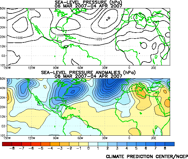
The cool area in the Eastern Atlantic has faded.The Western Atlantic still has cool anomalies.
In the Pacific the cool la nina continues but less cool waters are noted west of 160w.
0 likes
Visit the Caribbean-Central America Weather Thread where you can find at first post web cams,radars
and observations from Caribbean basin members Click Here
and observations from Caribbean basin members Click Here

-
Coredesat
Hurricane Hunter 914 wrote:Warming up in the Atlantic a bit but still needs warmer water before it's officially El nino(well at least that's what I heard).
Warmer waters in the Atlantic are not characteristic of an El Nino - that refers to the Pacific.
That map up there's interesting, though, because you can clearly see the area of cooler water in the Pacific, around the Equator.
0 likes

-
Matt-hurricanewatcher
Interesting pattern setting up.
1# The central and Eastern Atlantic is starting to warm....
2# Cooler water is forming off the east coast=cooler sst's which means cooler Atmosphere above=a strong Bermuda high. Also the western Caribbean is colder then normal.
So for one a weaker Azores meaning more recurvers over the eastern to Central Atlatnic. But if anything gets under the bermuda it will likely be steered to the west. Then once over the Gulf northwestward.
0 likes
-
gatorcane
- S2K Supporter
- Posts: 23708
- Age: 48
- Joined: Sun Mar 13, 2005 3:54 pm
- Location: Boca Raton, FL
Interesting pattern setting up.
1# The central and Eastern Atlantic is starting to warm....
2# Cooler water is forming off the east coast=cooler sst's which means cooler Atmosphere above=a strong Bermuda high. Also the western Caribbean is colder then normal.
So for one a weaker Azores meaning more recurvers over the eastern to Central Atlatnic. But if anything gets under the bermuda it will likely be steered to the west. Then once over the Gulf northwestward.
Finally I am starting to get support for my theories. I am really starting to think this Bermuda High is going nowhere this summer - and we will see at least one major get steared around it and threaten the east coast of the U.S (probably SE FL)
0 likes

http://www.cpc.ncep.noaa.gov/products/h ... 00_30d.gif
Those SSTs are bound to rise without high pressure in the Atlantic Basin. This pattern reminds me some of last year, but of course not as persistent. I expect more warming in the SST charts next week.
How do you get the image to appear in your post?
Those SSTs are bound to rise without high pressure in the Atlantic Basin. This pattern reminds me some of last year, but of course not as persistent. I expect more warming in the SST charts next week.
How do you get the image to appear in your post?
0 likes
http://www.cpc.ncep.noaa.gov/products/h ... 00_30d.gif
If this were August instead of March... !!! That type of anomaly pattern is a favorable one...
If this were August instead of March... !!! That type of anomaly pattern is a favorable one...
0 likes
Who is online
Users browsing this forum: No registered users and 104 guests