2018 Tropics: Global Model Runs Discussion (Out to day 16)

This is the general tropical discussion area. Anyone can take their shot at predicting a storms path.

Moderator: S2k Moderators

Forum rules

The posts in this forum are NOT official forecasts and should not be used as such. They are just the opinion of the poster and may or may not be backed by sound meteorological data. They are NOT endorsed by any professional institution or STORM2K. For official information, please refer to products from the National Hurricane Center and National Weather Service.

Help Support Storm2K
Message
Author
User avatar
SoupBone
Category 5
Category 5
Posts: 3111
Joined: Tue Sep 20, 2005 5:24 pm

Re: 2018 Tropics: Global Model Runs Discussion (Out to day 16)

#741 Postby SoupBone » Fri Jun 08, 2018 12:19 pm

NDG wrote:
cycloneye wrote:Nothing from them so we will continue to stick here posting the runs.

Tropical Weather Outlook
NWS National Hurricane Center Miami FL
200 PM EDT Fri Jun 8 2018

For the North Atlantic...Caribbean Sea and the Gulf of Mexico:

Tropical cyclone formation is not expected during the next 5 days.

$$
Forecaster Pasch


Not surprised, not until the Euro comes on board will they not mention the possibilities of development in the western Caribbean/southern GOM.


But why? Do they distrust the GFS that much that they're discounting it completely? Doesn't seem to exude a whole lot of confidence when it continues to push this system run after run after run. It's....odd.
0 likes   
Personal Forecast Disclaimer:
The posts in this forum are NOT official forecast and should not be used as such. They are just the opinion of the poster and may or may not be backed by sound meteorological data. They are NOT endorsed by any professional institution or storm2k.org. For official information, please refer to the NHC and NWS products.

LarryWx
S2K Supporter
S2K Supporter
Posts: 6311
Joined: Sun Sep 07, 2003 2:04 pm
Location: GA

Re: 2018 Tropics: Global Model Runs Discussion (Out to day 16)

#742 Postby LarryWx » Fri Jun 08, 2018 12:22 pm

SoupBone wrote:
NDG wrote:
cycloneye wrote:Nothing from them so we will continue to stick here posting the runs.

Tropical Weather Outlook
NWS National Hurricane Center Miami FL
200 PM EDT Fri Jun 8 2018

For the North Atlantic...Caribbean Sea and the Gulf of Mexico:

Tropical cyclone formation is not expected during the next 5 days.

$$
Forecaster Pasch


Not surprised, not until the Euro comes on board will they not mention the possibilities of development in the western Caribbean/southern GOM.


But why? Do they distrust the GFS that much that they're discounting it completely? Doesn't seem to exude a whole lot of confidence when it continues to push this system run after run after run. It's....odd.


Part of the reasoning may be that even the GFS now suggests any possible genesis would likely be after 5 days.
0 likes   
Personal Forecast Disclaimer:
The posts in this forum are NOT official forecasts and should not be used as such. They are just the opinion of the poster and may or may not be backed by sound meteorological data. They are NOT endorsed by any professional institution or storm2k.org. For official information, please refer to the NHC and NWS products.

Aric Dunn
Category 5
Category 5
Posts: 21238
Age: 42
Joined: Sun Sep 19, 2004 9:58 pm
Location: Ready for the Chase.
Contact:

Re: 2018 Tropics: Global Model Runs Discussion (Out to day 16)

#743 Postby Aric Dunn » Fri Jun 08, 2018 12:31 pm

LarryWx wrote:
SoupBone wrote:
NDG wrote:
Not surprised, not until the Euro comes on board will they not mention the possibilities of development in the western Caribbean/southern GOM.


But why? Do they distrust the GFS that much that they're discounting it completely? Doesn't seem to exude a whole lot of confidence when it continues to push this system run after run after run. It's....odd.


Part of the reasoning may be that even the GFS now suggests any possible genesis would likely be after 5 days.


current GFS and CMC are 3 to 4 days. they, of course, interpret everything and make a judgment. They also have access to other model outputs we do not. most notably the florida state model which by all indications is superior to the current model suit.
0 likes   
Note: If I make a post that is brief. Please refer back to previous posts for the analysis or reasoning. I do not re-write/qoute what my initial post said each time.
If there is nothing before... then just ask :)

Space & Atmospheric Physicist, Embry-Riddle Aeronautical University,
I believe the sky is falling...

LarryWx
S2K Supporter
S2K Supporter
Posts: 6311
Joined: Sun Sep 07, 2003 2:04 pm
Location: GA

Re: 2018 Tropics: Global Model Runs Discussion (Out to day 16)

#744 Postby LarryWx » Fri Jun 08, 2018 12:39 pm

LarryWx wrote:
Siker wrote:GFS ensemble support is pretty good. I count 15/20 members with some sort of low in the Gulf on the 06z run.

Image


Yeah, I counted 8 sub 1004 mb lows in the GOM at different times that affect the US GOM coast 6/14-17 out of ~20 members. That is much more active than any recent GEFS run. Is this indicative of a true increased risk of genesis or is it a false alarm? In contrast, only 3 of 50 0Z EPS members were sub 1004. The model wars continue. Let's see what the 12Z model consensus shows.


Similar to the the relatvely active 6Z GEFS, I count 8-9 sub 1004 mb tropical GOM lows on the 12Z GEFS. They then hit the US Gulf coast 6/15-7.
0 likes   
Personal Forecast Disclaimer:
The posts in this forum are NOT official forecasts and should not be used as such. They are just the opinion of the poster and may or may not be backed by sound meteorological data. They are NOT endorsed by any professional institution or storm2k.org. For official information, please refer to the NHC and NWS products.

User avatar
MississippiWx
S2K Supporter
S2K Supporter
Posts: 1699
Joined: Sat Aug 14, 2010 1:44 pm
Location: Hattiesburg, Mississippi

Re: 2018 Tropics: Global Model Runs Discussion (Out to day 16)

#745 Postby MississippiWx » Fri Jun 08, 2018 12:43 pm

Fairly decent agreement between the GFS, CMC, and ICON on a tropical cyclone in the Central Gulf a week from now. The models are now finally pushing this up in time a bit. Seems like the GFS has just been a little anxious to get things going. Still not fully buying into it yet, but will say it is much more interesting now that other models are picking it up. The Euro not showing anything isn’t really surprising because it is usually the last to show genesis. This may end up being a Bay of Campeche/Central Mexico/South Texas theat before it's over. We will see.
1 likes   
This post is not an official forecast and should not be used as such. It is just the opinion of MississippiWx and may or may not be backed by sound meteorological data. It is not endorsed by any professional institution including storm2k.org. For Official Information please refer to the NHC and NWS products.

User avatar
NDG
S2K Supporter
S2K Supporter
Posts: 15446
Joined: Sun Jul 09, 2006 10:14 pm
Location: Orlando, FL

Re: 2018 Tropics: Global Model Runs Discussion (Out to day 16)

#746 Postby NDG » Fri Jun 08, 2018 12:46 pm

Aric Dunn wrote:
LarryWx wrote:
SoupBone wrote:
But why? Do they distrust the GFS that much that they're discounting it completely? Doesn't seem to exude a whole lot of confidence when it continues to push this system run after run after run. It's....odd.


Part of the reasoning may be that even the GFS now suggests any possible genesis would likely be after 5 days.


current GFS and CMC are 3 to 4 days. they, of course, interpret everything and make a judgment. They also have access to other model outputs we do not. most notably the florida state model which by all indications is superior to the current model suit.


The FSU model is a super ensemble model, I believe they only use it on forecasting the track & intensity of an already developed system. Somebody correct me if I'm wrong.
0 likes   

User avatar
stormhunter7
Category 2
Category 2
Posts: 762
Joined: Mon May 26, 2008 3:13 pm
Location: Panama City Beach, Florida
Contact:

Re: 2018 Tropics: Global Model Runs Discussion (Out to day 16)

#747 Postby stormhunter7 » Fri Jun 08, 2018 12:49 pm

Superensemble hurricane model hailed as 'one of FSU's greatest contributions to science'

https://www.tallahassee.com/story/news/hurricane/2018/06/04/forecasting-model-created-florida-state-critical-tool-national-hurricane-center/661956002/

It uses a combination of weighted, bias-corrected input models to create track and intensity forecasts for hurricanes and tropical storms,” said Richard Pasch, senior hurricane specialist at the National Hurricane Center. “This differs from a simple model consensus forecast (TCON or TVCN), which uses a simple average of the input models. The FSSE has been one of the most accurate numerical guidance tools for hurricane forecasting and warning at the National Hurricane Center.”
2 likes   
The following post is NOT an official forecast and should not be used as such. It is just the opinion of the poster and may or may not be backed by sound meteorological data. It is NOT endorsed by any professional institution including storm2k.org For Official Information please refer to the NHC and NWS products. http://www.nhc.noaa.gov

User avatar
ronjon
Category 5
Category 5
Posts: 4822
Joined: Fri Aug 19, 2005 5:17 pm
Location: Hernando Beach, FL

Re: 2018 Tropics: Global Model Runs Discussion (Out to day 16)

#748 Postby ronjon » Fri Jun 08, 2018 12:59 pm

NDG wrote:
Aric Dunn wrote:
LarryWx wrote:
Part of the reasoning may be that even the GFS now suggests any possible genesis would likely be after 5 days.


current GFS and CMC are 3 to 4 days. they, of course, interpret everything and make a judgment. They also have access to other model outputs we do not. most notably the florida state model which by all indications is superior to the current model suit.


The FSU model is a super ensemble model, I believe they only use it on forecasting the track & intensity of an already developed system. Somebody correct me if I'm wrong.


Excerpts that came out from a nice article from a few days ago.

“It uses a combination of weighted, bias-corrected input models to create track and intensity forecasts for hurricanes and tropical storms,” said Richard Pasch, senior hurricane specialist at the National Hurricane Center. “This differs from a simple model consensus forecast (TCON or TVCN), which uses a simple average of the input models. The FSSE has been one of the most accurate numerical guidance tools for hurricane forecasting and warning at the National Hurricane Center.”

Mark Bourassa, associate director for the Center for Ocean-Atmospheric Prediction Studies and a meteorology professor at FSU, said the FSU invention is a combination or "ensemble" of other weather forecast models. Each of these models use knowledge of physical laws and the weather at the start of the forecast to estimate the weather in the future.

“NOAA routinely produces a simple average of such models,” he said. “The FSU Superensemble does more than that. It uses knowledge of model shortcomings, based on the proceeding weeks of forecasts, to adjust each of these forecasts before they are averaged. These corrections and the resulting improvement in the forecasts are what puts the 'super' in superensemble.“

Misra said the FSU Superensemble became known under Krishnamurti because of its success in forecasting the track and intensity of Atlantic hurricanes. In addition, he said, the model has outperformed other weather models in forecasting rainfall in the tropics and in forecasting climate a season in advance.

The uniqueness of the FSU Superensemble, said Misra, is in the weight given to each of the individual model forecasts entered into the superensemble. These weights are determined by statistical techniques on the performance of the individual model forecasts relative to the observations for past weather events.

“Superensemble uses a combination of forecast models,” he said. “It has usually shown itself to be superior to the best individual forecast model, which makes it quite unique. It is able to correct for systematic errors in the models and compensate for bad with good models through its weighted average technique.”

https://www.tallahassee.com/story/news/hurricane/2018/06/04/forecasting-model-created-florida-state-critical-tool-national-hurricane-center/661956002/
2 likes   

Frank2
Category 5
Category 5
Posts: 4061
Joined: Mon Jul 25, 2005 12:47 pm

Re: 2018 Tropics: Global Model Runs Discussion (Out to day 16)

#749 Postby Frank2 » Fri Jun 08, 2018 1:16 pm

This from today's Key West NWS forecast discussion:

...LONG TERM...

"...Moving into Wednesday and beyond, the trough in the Gulf very
slowly begins to break down and the Bermuda high builds into the
area through a deeper layer. The GFS GSM past Wednesday is
somewhat corrupted by the development of a tropical low in the
Gulf, which the other available GSM does not advertise. Overall
though, we should remain in a pattern slightly wetter than
climatology with lower boundary layer flow mainly out of the east
with winds at times fairly light and varying favoring mesoscale
activity along the islands."
Last edited by Frank2 on Fri Jun 08, 2018 1:16 pm, edited 1 time in total.
0 likes   

LarryWx
S2K Supporter
S2K Supporter
Posts: 6311
Joined: Sun Sep 07, 2003 2:04 pm
Location: GA

Re: 2018 Tropics: Global Model Runs Discussion (Out to day 16)

#750 Postby LarryWx » Fri Jun 08, 2018 1:16 pm

Out of 21 members of the 12Z CDN ensemble, I count 5 that go below 1004 mb in the W GOM 6/15-6, and they all then hit either TX or LA 6/15-8 (4 of the 5 hit as sub 1000 mb).
0 likes   
Personal Forecast Disclaimer:
The posts in this forum are NOT official forecasts and should not be used as such. They are just the opinion of the poster and may or may not be backed by sound meteorological data. They are NOT endorsed by any professional institution or storm2k.org. For official information, please refer to the NHC and NWS products.

User avatar
NDG
S2K Supporter
S2K Supporter
Posts: 15446
Joined: Sun Jul 09, 2006 10:14 pm
Location: Orlando, FL

Re: 2018 Tropics: Global Model Runs Discussion (Out to day 16)

#751 Postby NDG » Fri Jun 08, 2018 1:22 pm

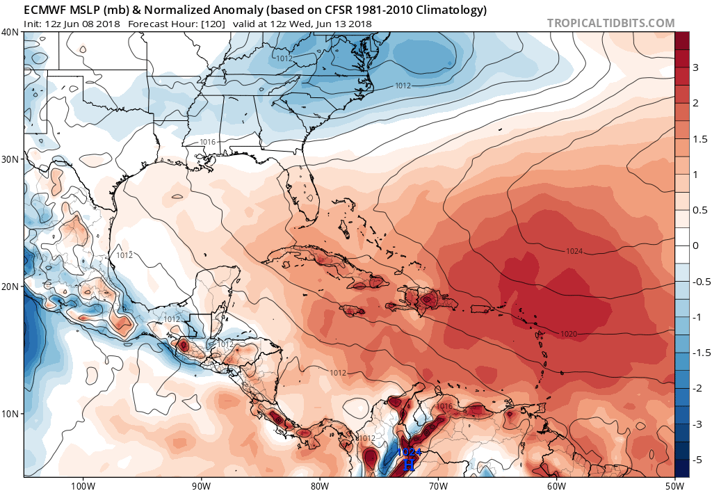
Absolutely nothing so far from the 12z Euro so far through day 5, but a friendly reminder how horrible it has been performing with Aletta.
0 likes   

LarryWx
S2K Supporter
S2K Supporter
Posts: 6311
Joined: Sun Sep 07, 2003 2:04 pm
Location: GA

Re: 2018 Tropics: Global Model Runs Discussion (Out to day 16)

#752 Postby LarryWx » Fri Jun 08, 2018 1:25 pm

Based on what I've already seen of the 12Z Euro, it will almost surely hold on with no genesis.
0 likes   
Personal Forecast Disclaimer:
The posts in this forum are NOT official forecasts and should not be used as such. They are just the opinion of the poster and may or may not be backed by sound meteorological data. They are NOT endorsed by any professional institution or storm2k.org. For official information, please refer to the NHC and NWS products.

User avatar
gatorcane
S2K Supporter
S2K Supporter
Posts: 23691
Age: 47
Joined: Sun Mar 13, 2005 3:54 pm
Location: Boca Raton, FL

Re: 2018 Tropics: Global Model Runs Discussion (Out to day 16)

#753 Postby gatorcane » Fri Jun 08, 2018 1:27 pm

Yep nothing but high pressure on the Euro out through day 5:

Image
0 likes   

User avatar
ronjon
Category 5
Category 5
Posts: 4822
Joined: Fri Aug 19, 2005 5:17 pm
Location: Hernando Beach, FL

Re: 2018 Tropics: Global Model Runs Discussion (Out to day 16)

#754 Postby ronjon » Fri Jun 08, 2018 1:27 pm

NDG wrote:Absolutely nothing so far from the 12z Euro so far through day 5, but a friendly reminder how horrible it has been performing with Aletta.


Yeah as board MET Alyono has said, EC has been performing poorly with genesis this year.
0 likes   

User avatar
NDG
S2K Supporter
S2K Supporter
Posts: 15446
Joined: Sun Jul 09, 2006 10:14 pm
Location: Orlando, FL

Re: 2018 Tropics: Global Model Runs Discussion (Out to day 16)

#755 Postby NDG » Fri Jun 08, 2018 1:34 pm

ronjon wrote:
NDG wrote:Absolutely nothing so far from the 12z Euro so far through day 5, but a friendly reminder how horrible it has been performing with Aletta.


Yeah as board MET Alyono has said, EC has been performing poorly with genesis this year.


Not just with genesis of Aletta but also forecast strength, just two days ago it was forecasting it to be a moderate TS today.
0 likes   

LarryWx
S2K Supporter
S2K Supporter
Posts: 6311
Joined: Sun Sep 07, 2003 2:04 pm
Location: GA

Re: 2018 Tropics: Global Model Runs Discussion (Out to day 16)

#756 Postby LarryWx » Fri Jun 08, 2018 1:36 pm

ronjon wrote:
NDG wrote:Absolutely nothing so far from the 12z Euro so far through day 5, but a friendly reminder how horrible it has been performing with Aletta.


Yeah as board MET Alyono has said, EC has been performing poorly with genesis this year.


We have a true model battle between a "genesis shy" Euro and a "genesis happy" GFS. Is there a genesis "just right" model we can semi-rely on? :lol:
3 likes   
Personal Forecast Disclaimer:
The posts in this forum are NOT official forecasts and should not be used as such. They are just the opinion of the poster and may or may not be backed by sound meteorological data. They are NOT endorsed by any professional institution or storm2k.org. For official information, please refer to the NHC and NWS products.

PSUHiker31
Tropical Storm
Tropical Storm
Posts: 114
Joined: Tue Oct 03, 2017 2:36 pm

Re: 2018 Tropics: Global Model Runs Discussion (Out to day 16)

#757 Postby PSUHiker31 » Fri Jun 08, 2018 1:41 pm

The Euro's skill at genesis has been a slow slide for a few years now as if it is overdoing every ridge. I still take development with a grain of salt, but definitely need to monitor the potential for development
0 likes   

Aric Dunn
Category 5
Category 5
Posts: 21238
Age: 42
Joined: Sun Sep 19, 2004 9:58 pm
Location: Ready for the Chase.
Contact:

Re: 2018 Tropics: Global Model Runs Discussion (Out to day 16)

#758 Postby Aric Dunn » Fri Jun 08, 2018 1:44 pm

towards the end of the EURO it does send some vorticity out of the Yucatan which you can track back to the SW carrib then up to central texas.
3 likes   
Note: If I make a post that is brief. Please refer back to previous posts for the analysis or reasoning. I do not re-write/qoute what my initial post said each time.
If there is nothing before... then just ask :)

Space & Atmospheric Physicist, Embry-Riddle Aeronautical University,
I believe the sky is falling...

User avatar
NDG
S2K Supporter
S2K Supporter
Posts: 15446
Joined: Sun Jul 09, 2006 10:14 pm
Location: Orlando, FL

Re: 2018 Tropics: Global Model Runs Discussion (Out to day 16)

#759 Postby NDG » Fri Jun 08, 2018 1:55 pm

LarryWx wrote:
ronjon wrote:
NDG wrote:Absolutely nothing so far from the 12z Euro so far through day 5, but a friendly reminder how horrible it has been performing with Aletta.


Yeah as board MET Alyono has said, EC has been performing poorly with genesis this year.


We have a true model battle between a "genesis shy" Euro and a "genesis happy" GFS. Is there a genesis "just right" model we can semi-rely on? :lol:


The Euro is also "genesis happy", whenever a trough/trough comes down to the northern gulf coast, most times wants to develop a weak system underneath the trough which most times never happens.
0 likes   

User avatar
Steve
S2K Supporter
S2K Supporter
Posts: 9621
Joined: Sat Apr 05, 2003 11:41 pm
Location: Not a state-caster

Re: 2018 Tropics: Global Model Runs Discussion (Out to day 16)

#760 Postby Steve » Fri Jun 08, 2018 1:56 pm

Aric Dunn wrote:towards the end of the EURO it does send some vorticity out of the Yucatan which you can track back to the SW carrib then up to central texas.


Makes sense if the Atlantic ridge is going to pulse west during that time period. The 500mb EC shows it pretty well as does the JMA.
0 likes   


Return to “Talkin' Tropics”

Who is online

Users browsing this forum: Google Adsense [Bot], Hurricane2000 and 57 guests