
2021 Indicators: SST's / SAL / MSLP / Shear / Steering / Instability / Sat Images
Moderator: S2k Moderators
Forum rules

The posts in this forum are NOT official forecasts and should not be used as such. They are just the opinion of the poster and may or may not be backed by sound meteorological data. They are NOT endorsed by any professional institution or STORM2K. For official information, please refer to products from the National Hurricane Center and National Weather Service.
-
tolakram
- Admin

- Posts: 20186
- Age: 62
- Joined: Sun Aug 27, 2006 8:23 pm
- Location: Florence, KY (name is Mark)
Re: 2021 Indicators: SST's / SAL / MSLP / Shear / Steering / Instability / Sat Images
The numerous waves in the MDR seem to be moving the needle.
0 likes
M a r k
- - - - -
Join us in chat: Storm2K Chatroom Invite. Android and IOS apps also available.
The posts in this forum are NOT official forecasts and should not be used as such. Posts are NOT endorsed by any professional institution or STORM2K.org. For official information and forecasts, please refer to NHC and NWS products.

Re: 2021 Indicators: SST's / SAL / MSLP / Shear / Steering / Instability / Sat Images
Ubuntwo wrote:NotSparta wrote:Ubuntwo wrote:This.
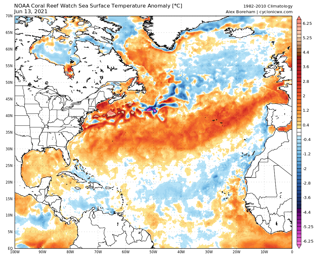
CRW (1985-2012 baseline):
https://media.discordapp.net/attachments/289981599448039425/853651781506695168/ct5km_ssta_v3.png?width=1107&height=676
Turns out CRW doesn't really have that climo and instead tries to emulate the 1985-93 climatology which makes the MDR appear far warmer than it really is. Here's the CRW data but with a 1982-2010 baseline:
https://uploads.disquscdn.com/images/c40b770d4db7983fc7a800907d8ab9b59b315164330177d9e0b0ede25e8b8bb9.png
Not as cold as CDAS, but it isn't nearly as warm as that map makes you think
Interesting. That's also in line with OISST which uses 1990-2019.
https://cdn.discordapp.com/attachments/289981599448039425/853779715014131742/oisst_anom_1d_tropatl_2021061200.png
I tried to find a solid SST profile analog but there's no real match. 2018 is close with the very warm subtropics, but its MDR was FAR cooler.

2015 is a partial analog, although with cooler subtropics and MDR. 2003 also displays a weak similarity. This is conjecture, but I think the importance of an SST profile (esp. at this point in the year) is greatly overstated when holistically compared to other factors like the WAM, dominant ridging, MJO tendency, ENSO, and zonal winds.
2010 had a record-warm MDR at this point in the year: besting 2020, 2017, and 2005 by a long shot. 2010 was certainly very active, though not on the level of those three years, and didn't yield a single US cane landfall.

By June 12th, 2004's MDR was actually cooler than this year. That didn't seem to stop the year from producing 4 intense Florida-landfalling canes.

Certain users in this forum seem to think there's a formula to long-range TC forecasting, as if a few key profiles and oscillation states directly lead to impacts in one part of the basin or another. That just isn't the case. Those factors can serve as hints towards activity, and maybe suggest a very general zone in which activity will be elevated. We don't have the forecasting skill for much more than that. So buckle up and see what happens. As with every other year, we'll all eventually be surprised at which areas take big hits (or vice versa).
Last edited by Ubuntwo on Sun Jun 13, 2021 10:36 pm, edited 2 times in total.
11 likes
Kendall -> SLO -> PBC
Memorable Storms: Katrina (for its Florida landfall...) Wilma Matthew Irma
Memorable Storms: Katrina (for its Florida landfall...) Wilma Matthew Irma
-
Category5Kaiju

- Category 5

- Posts: 4334
- Joined: Thu Dec 24, 2020 12:45 pm
- Location: Seattle and Phoenix
Re: 2021 Indicators: SST's / SAL / MSLP / Shear / Steering / Instability / Sat Images
With this talk of a lot of waves in the MDR now, I wonder if this is a sign that the WAM is trying to ramp up?
4 likes
Unless explicitly stated, all info in my posts is based on my own opinions and observations. Tropical storms and hurricanes can be extremely dangerous. Refer to an accredited weather research agency or meteorologist if you need to make serious decisions regarding an approaching storm.
-
Kingarabian

- S2K Supporter

- Posts: 16366
- Joined: Sat Aug 08, 2009 3:06 am
- Location: Honolulu, Hawaii
Re: 2021 Indicators: SST's / SAL / MSLP / Shear / Steering / Instability / Sat Images
This will make or break the EPAC and Atlantic hurricane season:

It's pretty simple. If this upwelling Kelvin wave can surface and negate the warming over the Nino regions, it will cut off the rising motion in the EPAC and it will allow the Atlantic to have a very active hurricane season. Sorta similar situation in 2017.
If it doesn't. Then it's likely the EPAC will be in a prolonged weak +ENSO state which will allow it to compete. Historically, an active EPAC means a slower Atlantic.
15 likes
RIP Kobe Bryant
-
NXStumpy_Robothing
- Category 1

- Posts: 335
- Age: 25
- Joined: Fri Jun 05, 2020 11:50 pm
- Location: North Georgia
Re: 2021 Indicators: SST's / SAL / MSLP / Shear / Steering / Instability / Sat Images
Category5Kaiju wrote:With this talk of a lot of waves in the MDR now, I wonder if this is a sign that the WAM is trying to ramp up?
Well, as it turns out, the recent impressive stretch of waves off the coast of Africa have had some very beneficial factors going their way, especially the big wave that is currently departing the African coast. These factors have contributed to the extremely impressive convection for June, and a few ensemble members even want to make it into a short-lived TC, which is pretty much unprecedented climatologically. I don't expect anything to happen, but certainly worth noting for what the wave is and what's assisting it, as well as another sign for the potential of the ASW/AEJ this year. I'm not sure if these impressive tropical waves can be solely attributed to a stronger WAM (for now, at least).
https://twitter.com/webberweather/status/1404216070441897990
4 likes
Undergraduate Meteorology Student, Georgia Institute of Technology
-
Stormybajan

- Category 1
- Posts: 453
- Joined: Thu May 20, 2021 3:21 pm
- Location: Windward Islands
Re: 2021 Indicators: SST's / SAL / MSLP / Shear / Steering / Instability / Sat Images
NXStumpy_Robothing wrote:Category5Kaiju wrote:With this talk of a lot of waves in the MDR now, I wonder if this is a sign that the WAM is trying to ramp up?
Well, as it turns out, the recent impressive stretch of waves off the coast of Africa have had some very beneficial factors going their way, especially the big wave that is currently departing the African coast. These factors have contributed to the extremely impressive convection for June, and a few ensemble members even want to make it into a short-lived TC, which is pretty much unprecedented climatologically. I don't expect anything to happen, but certainly worth noting for what the wave is and what's assisting it, as well as another sign for the potential of the ASW/AEJ this year. I'm not sure if these impressive tropical waves can be solely attributed to a stronger WAM (for now, at least).
https://twitter.com/webberweather/status/1404216070441897990
Interesting indeed given GFS wants a weak 1008 mb tropical depression of this chonk wave, doubt it'll happen but very interesting to see this in June
0 likes
Sad West Indies and Manchester United fan ⚽️
-
IsabelaWeather
- Category 1
- Posts: 316
- Age: 36
- Joined: Tue Jul 07, 2020 7:29 am
- Location: Isabela, Puerto Rico
Re: 2021 Indicators: SST's / SAL / MSLP / Shear / Steering / Instability / Sat Images
I'm rather confused. Everyone seems to be looking at the SSTA but anomalies dont matter for TC's, what matters are actual numbers. Most of the Atlantic is already warm enough for tropical cyclones and it will warm more before ASO.

5 likes
-
galaxy401

- Category 5
- Posts: 2446
- Age: 30
- Joined: Sat Aug 25, 2012 9:04 pm
- Location: Casa Grande, Arizona
Re: 2021 Indicators: SST's / SAL / MSLP / Shear / Steering / Instability / Sat Images
With how warm the subtropics are this year, I won't be surprised to see several mid-latitude storms spawn up out of nowhere with little model support. Similar to 2011 and 2018. There's already a disturbance off of the Carolinas.
0 likes
Got my eyes on moving right into Hurricane Alley: Florida.
-
Kingarabian
- S2K Supporter
- Posts: 16366
- Joined: Sat Aug 08, 2009 3:06 am
- Location: Honolulu, Hawaii
Re: 2021 Indicators: SST's / SAL / MSLP / Shear / Steering / Instability / Sat Images
IsabelaWeather wrote:I'm rather confused. Everyone seems to be looking at the SSTA but anomalies dont matter for TC's, what matters are actual numbers. Most of the Atlantic is already warm enough for tropical cyclones and it will warm more before ASO.
http://wxmaps.org/pix/atlpot.png
Anomalously warmer waters means anomalously more rising motion. That means a higher chance for TCG and vice versa. It's the same idea with El Nino/La Nina in the EPAC.
2 likes
RIP Kobe Bryant
-
cycloneye

- Admin
- Posts: 149505
- Age: 69
- Joined: Thu Oct 10, 2002 10:54 am
- Location: San Juan, Puerto Rico
Re: 2021 Indicators: SST's / SAL / MSLP / Shear / Steering / Instability / Sat Images
2 likes
Visit the Caribbean-Central America Weather Thread where you can find at first post web cams,radars
and observations from Caribbean basin members Click Here
and observations from Caribbean basin members Click Here
-
Shell Mound
- Category 5
- Posts: 2432
- Age: 33
- Joined: Thu Sep 07, 2017 3:39 pm
- Location: St. Petersburg, FL → Scandinavia
Re: 2021 Indicators: SST's / SAL / MSLP / Shear / Steering / Instability / Sat Images
cycloneye wrote:https://twitter.com/cyclonicwx/status/1404417538239442956
https://twitter.com/AndyHazelton/status/1404418498898583554
https://twitter.com/webberweather/status/1404428777518628865
https://twitter.com/AndyHazelton/status/1404433616961249291
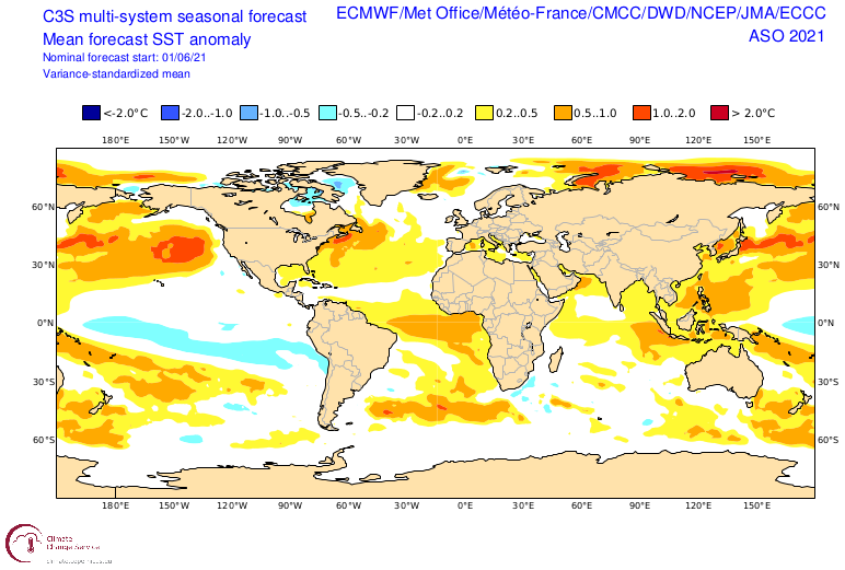
As noted above, the upcoming WWB over the MDR seems to be largely related to the MJO/CCKW rather than the ASW (African monsoon). Also, the westerly anomalies, while respectable, do not look to be especially strong through the upcoming period. I have certainly seen stronger and more persistent WWBs over the MDR in the past. Given that the MDR is currently well below average, we would need to see stronger and more persistent westerlies than is currently forecast. Additionally, model guidance for June (see image above) still suggests that the coldest SST anomalies in the equatorial Pacific will be west-based (in Niño 3.4+4 vs. Niño 1+2) during ASO. Even with a solid -PDO/-IOD in place, this would, combined with a warm subtropical Atlantic and Atlantic Niño, tend to impart considerable sinking air and enhanced low-level trades as well as a stronger-than-normal TUTT during the peak of the season. The EC is also showing enhanced precipitation over the eastern North Pacific during ASO, suggestive of outflow-induced shear extending eastward into the Atlantic basin. I don’t think that an active African monsoon alone will be able to sufficiently compensate for these negatives as to result in CSU’s projected ACE of ≥ 150.
Last edited by Shell Mound on Mon Jun 14, 2021 9:58 am, edited 2 times in total.
0 likes
CVW / MiamiensisWx / Shell Mound
The posts in this forum are NOT official forecasts and should not be used as such. They are just the opinion of the poster and may or may not be backed by sound meteorological data. They are NOT endorsed by any professional institution or STORM2K. For official information, please refer to products from the NHC and NWS.

Re: 2021 Indicators: SST's / SAL / MSLP / Shear / Steering / Instability / Sat Images
Even with a cool MDR, something is very clear today: the Atlantic based state and WAM are both quite favorable. 93L has become a TD/TS out of nowhere, 92L has a good chance of becoming Claudette in a few days, and there’s a huge AEW that is being marked for potential development….and it’s only June 14th. This season looks to be one of a handful with two or more June storms.
With a favorable base state and WAM, a slightly cooler than average MDR probably won’t impact the number of named storms that much. It remains to be seen if this’ll be a quantity-over-quality year like 2019 and most of 2020, or a season with impressive quantity and quality like 2005 and 2017.
With a favorable base state and WAM, a slightly cooler than average MDR probably won’t impact the number of named storms that much. It remains to be seen if this’ll be a quantity-over-quality year like 2019 and most of 2020, or a season with impressive quantity and quality like 2005 and 2017.
6 likes
Irene '11 Sandy '12 Hermine '16 5/15/2018 Derecho Fay '20 Isaias '20 Elsa '21 Henri '21 Ida '21
I am only a meteorology enthusiast who knows a decent amount about tropical cyclones. Look to the professional mets, the NHC, or your local weather office for the best information.
I am only a meteorology enthusiast who knows a decent amount about tropical cyclones. Look to the professional mets, the NHC, or your local weather office for the best information.
-
Shell Mound
- Category 5
- Posts: 2432
- Age: 33
- Joined: Thu Sep 07, 2017 3:39 pm
- Location: St. Petersburg, FL → Scandinavia
Re: 2021 Indicators: SST's / SAL / MSLP / Shear / Steering / Instability / Sat Images
aspen wrote:Even with a cool MDR, something is very clear today: the Atlantic based state and WAM are both quite favorable. 93L has become a TD/TS out of nowhere, 92L has a good chance of becoming Claudette in a few days, and there’s a huge AEW that is being marked for potential development….and it’s only June 14th. This season looks to be one of a handful with two or more June storms.
Personally, I would wait for 92L and 93L to be named as tropical cyclones first before making definitive declarations about this season’s potential. Even then, three weak, short-lived, early-season systems in the subtropics, including Ana, would be far from remarkable. I will become much more intrigued if the latest AEW somehow manages to become a brief TS over the MDR; that would perhaps suggest a more conducive base-state in the deep tropics than I currently suspect. Historically, TS formation in the MDR during late June or the first half of July is a much stronger indicator of hyperactivity come the peak of the season. 2018 featured Hurricane Beryl in the MDR in the very first week of July, for instance. If 2021 is at least as conducive, it should at least perform at 2018’s level and generate a hurricane in the MDR and/or Caribbean in July.
Biggest unfavourable factors:
- Likelihood of warmer Niño 1+2 (thus enhanced EPAC activity) vs. Niño 3.4+4 offsetting -PDO/-IOD/ASW, inducing sinking air, above-average VWS, and TUTT over Caribbean/MDR during ASO
- Warm subtropical Atlantic and Atlantic Niño combining with relatively warm Niño 1+2 and relatively cool MDR to amplify said hostile conditions during the seasonal peak
0 likes
CVW / MiamiensisWx / Shell Mound
The posts in this forum are NOT official forecasts and should not be used as such. They are just the opinion of the poster and may or may not be backed by sound meteorological data. They are NOT endorsed by any professional institution or STORM2K. For official information, please refer to products from the NHC and NWS.
-
Category5Kaiju
- Category 5
- Posts: 4334
- Joined: Thu Dec 24, 2020 12:45 pm
- Location: Seattle and Phoenix
Re: 2021 Indicators: SST's / SAL / MSLP / Shear / Steering / Instability / Sat Images
Not sure if this is true, but I wonder if there are some oceanic and/or atmospheric variables that were present last year and helped really boost that season that are also lingering and contributing to this active June?
Also, I do think the AEW is something to watch. If it does become Claudette or Danny, then I think that is a very interesting and ominous signal for what's to come, especially in terms of long-track MDR systems later this season.
Also, I do think the AEW is something to watch. If it does become Claudette or Danny, then I think that is a very interesting and ominous signal for what's to come, especially in terms of long-track MDR systems later this season.
0 likes
Unless explicitly stated, all info in my posts is based on my own opinions and observations. Tropical storms and hurricanes can be extremely dangerous. Refer to an accredited weather research agency or meteorologist if you need to make serious decisions regarding an approaching storm.
Re: 2021 Indicators: SST's / SAL / MSLP / Shear / Steering / Instability / Sat Images
Shell Mound wrote:aspen wrote:Even with a cool MDR, something is very clear today: the Atlantic based state and WAM are both quite favorable. 93L has become a TD/TS out of nowhere, 92L has a good chance of becoming Claudette in a few days, and there’s a huge AEW that is being marked for potential development….and it’s only June 14th. This season looks to be one of a handful with two or more June storms.
Personally, I would wait for 92L and 93L to be named as tropical cyclones first before making definitive declarations about this season’s potential. Even then, three weak, short-lived, early-season systems in the subtropics, including Ana, would be far from remarkable. I will become much more intrigued if the latest AEW somehow manages to become a brief TS over the MDR; that would perhaps suggest a more conducive base-state in the deep tropics than I currently suspect. Historically, TS formation in the MDR during late June or the first half of July is a much stronger indicator of hyperactivity come the peak of the season. 2018 featured Hurricane Beryl in the MDR in the very first week of July, for instance. If 2021 is at least as conducive, it should at least perform at 2018’s level and generate a hurricane in the MDR and/or Caribbean in July.
Biggest unfavourable factors:If these negatives were blunted/subdued or not present, I would certainly be keen on forecasting a hyperactive year. But I think these will keep ACE below 130.
- Likelihood of warmer Niño 1+2 (thus enhanced EPAC activity) vs. Niño 3.4+4 offsetting -PDO/-IOD/ASW, inducing sinking air, above-average VWS, and TUTT over Caribbean/MDR during ASO
- Warm subtropical Atlantic and Atlantic Niño combining with relatively warm Niño 1+2 and relatively cool MDR to amplify said hostile conditions during the seasonal peak
2021 doesn’t need to have a super early MDR hurricane like Beryl, but last year I went through every season from 1980 to present day and found a strong correlation between MDR or AEW-based storms/hurricanes in July and overall season activity. Accounting for 2020 (which had 3 AEW July systems, two of which became hurricanes), the average season numbers are:
—16.9 named storms
—9.0 hurricanes
—4.1 majors
—160.29 ACE
For seasons that had any non-AEW-based July system, even if they also had a tropical wave born system as well, the average is much lower:
—13.4 named storms
—6.6 hurricanes
—2.9 majors
—115.40 ACE
So yes, July activity is a very strong sign of what the rest of the season could be like. However, the fact that a lot of things are attempting to form this early does make the predictions for an above-average season more likely…unless there’s a sudden shift to +ENSO.
6 likes
Irene '11 Sandy '12 Hermine '16 5/15/2018 Derecho Fay '20 Isaias '20 Elsa '21 Henri '21 Ida '21
I am only a meteorology enthusiast who knows a decent amount about tropical cyclones. Look to the professional mets, the NHC, or your local weather office for the best information.
I am only a meteorology enthusiast who knows a decent amount about tropical cyclones. Look to the professional mets, the NHC, or your local weather office for the best information.
-
IsabelaWeather
- Category 1
- Posts: 316
- Age: 36
- Joined: Tue Jul 07, 2020 7:29 am
- Location: Isabela, Puerto Rico
Re: 2021 Indicators: SST's / SAL / MSLP / Shear / Steering / Instability / Sat Images
Kingarabian wrote:IsabelaWeather wrote:I'm rather confused. Everyone seems to be looking at the SSTA but anomalies dont matter for TC's, what matters are actual numbers. Most of the Atlantic is already warm enough for tropical cyclones and it will warm more before ASO.
http://wxmaps.org/pix/atlpot.png
Anomalously warmer waters means anomalously more rising motion. That means a higher chance for TCG and vice versa. It's the same idea with El Nino/La Nina in the EPAC.
I mean, you don't need to school me. I understand warmer water allows for more OHC and more rising air. But as I said the ocean is currently warm enough for major hurricanes. What matters is how warm the water is, and it is currently warm even if its cooler than average.
Also, just because water is much warmer than average that doesn't mean we will get more storms. There are a lot of other things to focus on.
2 likes
-
NXStumpy_Robothing
- Category 1
- Posts: 335
- Age: 25
- Joined: Fri Jun 05, 2020 11:50 pm
- Location: North Georgia
Re: 2021 Indicators: SST's / SAL / MSLP / Shear / Steering / Instability / Sat Images
That's a pretty active look for the MDR in the Atlantic come peak season, if this forecast is to be believed.
https://twitter.com/BenNollWeather/status/1404438488506720256
https://twitter.com/BenNollWeather/status/1404438488506720256
1 likes
Undergraduate Meteorology Student, Georgia Institute of Technology
-
cycloneye
- Admin
- Posts: 149505
- Age: 69
- Joined: Thu Oct 10, 2002 10:54 am
- Location: San Juan, Puerto Rico
Re: 2021 Indicators: SST's / SAL / MSLP / Shear / Steering / Instability / Sat Images
0 likes
Visit the Caribbean-Central America Weather Thread where you can find at first post web cams,radars
and observations from Caribbean basin members Click Here
and observations from Caribbean basin members Click Here
Re: 2021 Indicators: SST's / SAL / MSLP / Shear / Steering / Instability / Sat Images
cycloneye wrote:https://twitter.com/BenNollWeather/status/1404423378098868229
The standing wave over Africa looks really strong in July and August. Maybe we’ll see higher activity around that time, perhaps comparable to 2020 (5 total storms in July, including 3 AEW-based systems and 2 hurricanes).
0 likes
Irene '11 Sandy '12 Hermine '16 5/15/2018 Derecho Fay '20 Isaias '20 Elsa '21 Henri '21 Ida '21
I am only a meteorology enthusiast who knows a decent amount about tropical cyclones. Look to the professional mets, the NHC, or your local weather office for the best information.
I am only a meteorology enthusiast who knows a decent amount about tropical cyclones. Look to the professional mets, the NHC, or your local weather office for the best information.
-
Stormybajan
- Category 1
- Posts: 453
- Joined: Thu May 20, 2021 3:21 pm
- Location: Windward Islands
Re: 2021 Indicators: SST's / SAL / MSLP / Shear / Steering / Instability / Sat Images
NXStumpy_Robothing wrote:That's a pretty active look for the MDR in the Atlantic come peak season, if this forecast is to be believed.
https://twitter.com/BenNollWeather/status/1404438488506720256
Are those low riders I see...
0 likes
Sad West Indies and Manchester United fan ⚽️