2022 Indicators (SSTs/SAL/MSLP/Shear/Steering/Instability) and >Day 16 Models
Moderator: S2k Moderators
Forum rules

The posts in this forum are NOT official forecasts and should not be used as such. They are just the opinion of the poster and may or may not be backed by sound meteorological data. They are NOT endorsed by any professional institution or STORM2K. For official information, please refer to products from the National Hurricane Center and National Weather Service.
-
tolakram
- Admin

- Posts: 20186
- Age: 62
- Joined: Sun Aug 27, 2006 8:23 pm
- Location: Florence, KY (name is Mark)
Re: 2022 indicators: SSTs / SAL / MSLP / shear / steering / instability / images
How reliable is a 240 hour model plot of the GEFS?
0 likes
M a r k
- - - - -
Join us in chat: Storm2K Chatroom Invite. Android and IOS apps also available.
The posts in this forum are NOT official forecasts and should not be used as such. Posts are NOT endorsed by any professional institution or STORM2K.org. For official information and forecasts, please refer to NHC and NWS products.
-
skyline385

- Category 5

- Posts: 2728
- Age: 35
- Joined: Wed Aug 26, 2020 11:15 pm
- Location: Houston TX
2022 indicators: SSTs / SAL / MSLP / shear / steering / instability / images
Category5Kaiju wrote:skyline385 wrote:https://twitter.com/andyhazelton/status/1523641314348507136
Welp, a bout of trade winds in mid-May? Alright, cool MDR incoming for August! CV season will not happen, and I'm calling this season a dud right now.
Ok, no, but seriously; I personally think in the grand scheme of things, that bout of trades will likely not really impact the overall ceiling of the season, particularly if the forecasts for weaker trades near the end of the month verify as Kingarabian pointed our earlier on this page
Yea lets all put more weight into model forecasts more farther out, including forecasts even 2-3 months out (which is totally not subject to change) but ignore the one for next week. This season is clearly going to be the most hyperactive of all hyperactive seasons.
Seriously guys, this is literally an expert in the field sharing his outlook for the next few weeks. No need to overreact in every post as if he is saying the season is canceled.
What's funny is that he even jokes about this overreaction in his tweet.
https://twitter.com/andyhazelton/status/1523643660885438464
0 likes
-
Category5Kaiju

- Category 5
- Posts: 4346
- Joined: Thu Dec 24, 2020 12:45 pm
- Location: Seattle during the summer, Phoenix during the winter
Re: 2022 indicators: SSTs / SAL / MSLP / shear / steering / instability / images
skyline385 wrote:Category5Kaiju wrote:skyline385 wrote:https://twitter.com/andyhazelton/status/1523641314348507136
Welp, a bout of trade winds in mid-May? Alright, cool MDR incoming for August! CV season will not happen, and I'm calling this season a dud right now.
Ok, no, but seriously; I personally think in the grand scheme of things, that bout of trades will likely not really impact the overall ceiling of the season, particularly if the forecasts for weaker trades near the end of the month verify as Kingarabian pointed our earlier on this page
Yea lets all put more weight into model forecasts more farther out, including forecasts even 2-3 months out (which is totally not subject to change) but ignore the one for next week. This season is clearly going to be the most hyperactive of all hyperactive seasons.
Seriously guys, this is literally an expert in the field sharing his outlook for the next few weeks. No need to overreact in every post as if he is saying the season is canceled.
What's funny is that he even jokes about this overreaction in his tweet.
https://twitter.com/andyhazelton/status/1523643660885438464
Oh, I know exactly what what being talked about in that Tweet; I was mainly referring to the idea that there are bound to be some individuals (especially on social media and those who are not as experienced as us, Andy, Phil, etc. but think they know much better) who automatically see this as a sign that the MDR will be shut down for business later in the season
0 likes
Unless explicitly stated, all information in my posts is based on my own opinions and observations. Tropical storms and hurricanes can be extremely dangerous. Refer to an accredited weather research agency or meteorologist if you need to make serious decisions regarding an approaching storm.
-
tolakram
- Admin
- Posts: 20186
- Age: 62
- Joined: Sun Aug 27, 2006 8:23 pm
- Location: Florence, KY (name is Mark)
Re: 2022 indicators: SSTs / SAL / MSLP / shear / steering / instability / images
I sent a few PM's, I'm also going to add this for everyone.
Twitter is twitter, and some of these tweets, from experts or otherwise, aren't very scientific. In fact I dare say some of the tweets are closer to clickbait than reasoned analysis. I added twitter support to make referencing things easier, please don't force me to take it down because some of you are interpreting a 240 hour GFS product as a forecast. Let twitter be twitter and keep it classy and respectful here please.
Twitter is twitter, and some of these tweets, from experts or otherwise, aren't very scientific. In fact I dare say some of the tweets are closer to clickbait than reasoned analysis. I added twitter support to make referencing things easier, please don't force me to take it down because some of you are interpreting a 240 hour GFS product as a forecast. Let twitter be twitter and keep it classy and respectful here please.
14 likes
M a r k
- - - - -
Join us in chat: Storm2K Chatroom Invite. Android and IOS apps also available.
The posts in this forum are NOT official forecasts and should not be used as such. Posts are NOT endorsed by any professional institution or STORM2K.org. For official information and forecasts, please refer to NHC and NWS products.
- - - - -
Join us in chat: Storm2K Chatroom Invite. Android and IOS apps also available.
The posts in this forum are NOT official forecasts and should not be used as such. Posts are NOT endorsed by any professional institution or STORM2K.org. For official information and forecasts, please refer to NHC and NWS products.
-
Kingarabian

- S2K Supporter

- Posts: 16379
- Joined: Sat Aug 08, 2009 3:06 am
- Location: Honolulu, Hawaii
Re: 2022 indicators: SSTs / SAL / MSLP / shear / steering / instability / images
skyline385 wrote:Category5Kaiju wrote:skyline385 wrote:https://twitter.com/andyhazelton/status/1523641314348507136
Welp, a bout of trade winds in mid-May? Alright, cool MDR incoming for August! CV season will not happen, and I'm calling this season a dud right now.
Ok, no, but seriously; I personally think in the grand scheme of things, that bout of trades will likely not really impact the overall ceiling of the season, particularly if the forecasts for weaker trades near the end of the month verify as Kingarabian pointed our earlier on this page
Yea lets all put more weight into model forecasts more farther out, including forecasts even 2-3 months out (which is totally not subject to change) but ignore the one for next week. This season is clearly going to be the most hyperactive of all hyperactive seasons.
Seriously guys, this is literally an expert in the field sharing his outlook for the next few weeks. No need to overreact in every post as if he is saying the season is canceled.
What's funny is that he even jokes about this overreaction in his tweet.
https://twitter.com/andyhazelton/status/1523643660885438464
In certain situations, a climate coupled model's forecast 2 months out can mean more than a global models 10-16 day forecast. The forecast I'm talking about is FROM the 3 month CFS and valid in less than a month. We'll see if it verifies but the anomalies have only gotten stronger with the timeframe coming in.
5/9/22:

4/22/22:

0 likes
RIP Kobe Bryant
-
AlphaToOmega
- Category 5
- Posts: 1448
- Joined: Sat Jun 26, 2021 10:51 am
- Location: Somewhere in Massachusetts
Re: 2022 indicators: SSTs / SAL / MSLP / shear / steering / instability / images
Of course the OISSTv2 fails to update. 
0 likes
-
DorkyMcDorkface

- Category 5
- Posts: 1043
- Age: 28
- Joined: Mon Sep 30, 2019 1:32 pm
- Location: Mid-Atlantic
Re: 2022 indicators: SSTs / SAL / MSLP / shear / steering / instability / images
AlphaToOmega wrote:Of course the OISSTv2 fails to update.
It's been having issues as of late yeah...just use Alex Boreham's CRW maps instead, they are higher res and use a better climo than NOAA's CRW maps so it's not always warm-biased in the Atlantic.
4 likes
Please note the thoughts expressed by this account are solely those of the user and are from a hobbyist perspective. For more comprehensive analysis, consult an actual professional meteorologist or meteorological agency.
Floyd 1999 | Isabel 2003 | Hanna 2008 | Irene 2011 | Sandy 2012 | Isaias 2020
-
Category5Kaiju
- Category 5
- Posts: 4346
- Joined: Thu Dec 24, 2020 12:45 pm
- Location: Seattle during the summer, Phoenix during the winter
Re: 2022 indicators: SSTs / SAL / MSLP / shear / steering / instability / images
Ok, so a few key bits of info that I see:
https://twitter.com/stormyday200/status/1523720186037403648
I think this is quite an interesting and logical assumption to make, and personally I do agree: I think we should expect to see periods of warming and cooling (for instance, recently there was warming, but there may be some cooling around the 18th/19th of this month or so). However, these are just limited fluctuations, and I'd have to imagine that the overall trend favors a net and steady/healthy warmup of the MDR through the rest of spring into the summer.
There's also this:
https://twitter.com/dmorris9661/status/1523716320671330305
This was exactly something that I commented a bit earlier in this thread, but that warm belt uniquely resembles 2004 to an extent during its summer time period. I cannot recall 2017 or 2020 even having that kind of pattern in May, but I do have to wonder if that warmth would gradually migrate southwest and allow the MDR to become warmer too?
0 likes
Unless explicitly stated, all information in my posts is based on my own opinions and observations. Tropical storms and hurricanes can be extremely dangerous. Refer to an accredited weather research agency or meteorologist if you need to make serious decisions regarding an approaching storm.
-
Stormybajan

- Category 1

- Posts: 453
- Joined: Thu May 20, 2021 3:21 pm
- Location: Windward Islands
Re: 2022 indicators: SSTs / SAL / MSLP / shear / steering / instability / images
Category5Kaiju wrote:Ok, so a few key bits of info that I see:
https://twitter.com/stormyday200/status/1523720186037403648
I think this is quite an interesting and logical assumption to make, and personally I do agree: I think we should expect to see periods of warming and cooling (for instance, recently there was warming, but there may be some cooling around the 18th/19th of this month or so). However, these are just limited fluctuations, and I'd have to imagine that the overall trend favors a net and steady/healthy warmup of the MDR through the rest of spring into the summer.
There's also this:
https://twitter.com/dmorris9661/status/1523716320671330305
This was exactly something that I commented a bit earlier in this thread, but that warm belt uniquely resembles 2004 to an extent during its summer time period. I cannot recall 2017 or 2020 even having that kind of pattern in May, but I do have to wonder if that warmth would gradually migrate southwest and allow the MDR to become warmer too?
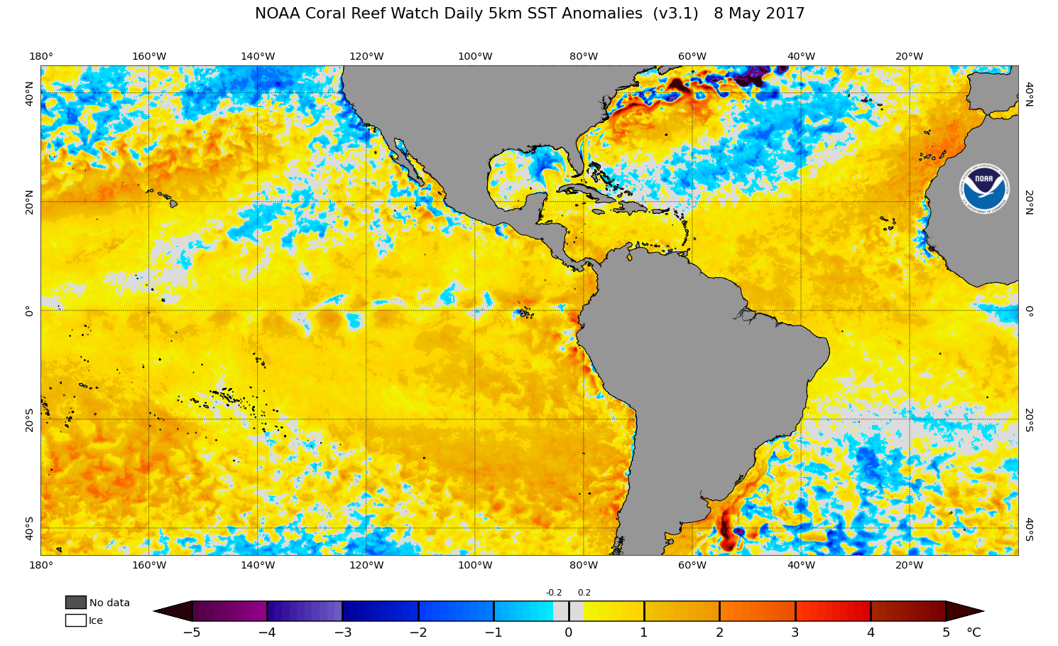
By this point 2017 and 2020 definitely were much warmer in the MDR than 2022 right now. There are just some seasons which early on are so anomalous with warmth that you know it was going to be an iconic/ hyperactive season.https://coralreefwatch.noaa.gov/data/5km/v3.1_op/image/daily/ssta/png/2017/05/ct5km_ssta_v3.1_west_20170508.png
2 likes
Sad West Indies and Manchester United fan ⚽️
-
ScottNAtlanta

- Category 5
- Posts: 2535
- Joined: Sat May 25, 2013 3:11 pm
- Location: Atlanta, GA
Re: 2022 indicators: SSTs / SAL / MSLP / shear / steering / instability / images
Stormybajan wrote:Category5Kaiju wrote:Ok, so a few key bits of info that I see:
https://twitter.com/stormyday200/status/1523720186037403648
I think this is quite an interesting and logical assumption to make, and personally I do agree: I think we should expect to see periods of warming and cooling (for instance, recently there was warming, but there may be some cooling around the 18th/19th of this month or so). However, these are just limited fluctuations, and I'd have to imagine that the overall trend favors a net and steady/healthy warmup of the MDR through the rest of spring into the summer.
There's also this:
https://twitter.com/dmorris9661/status/1523716320671330305
This was exactly something that I commented a bit earlier in this thread, but that warm belt uniquely resembles 2004 to an extent during its summer time period. I cannot recall 2017 or 2020 even having that kind of pattern in May, but I do have to wonder if that warmth would gradually migrate southwest and allow the MDR to become warmer too?
By this point 2017 and 2020 definitely were much warmer in the MDR than 2022 right now. There are just some seasons which early on are so anomalous with warmth that you know it was going to be an iconic/ hyperactive season.https://coralreefwatch.noaa.gov/data/5km/v3.1_op/image/daily/ssta/png/2017/05/ct5km_ssta_v3.1_west_20170508.png
There are some interesting similarities though with 2017. The subtropical Atlantic has cooled quite a bit setting up the warm over cold over warm that usually produces busy seasons and lowers pressures in the MDR. That storm that has been sitting well off the coast of NC has really worked to mix the water in that region cooling it quite a bit. Whenever you see that warm horse shoe...you need to take notice
3 likes
The posts in this forum are NOT official forecast and should not be used as such. They are just the opinion of the poster and may or may not be backed by sound meteorological data. They are NOT endorsed by any professional institution or storm2k.org. For official information, please refer to the NHC and NWS products.
-
ScottNAtlanta
- Category 5
- Posts: 2535
- Joined: Sat May 25, 2013 3:11 pm
- Location: Atlanta, GA
Re: 2022 Indicators (SSTs/SAL/MSLP/Shear/Steering/Instability) and >Day 16 Models
I've seen a couple of 2004 comparisons, but remember that 2004 had a weakening el nino and the first storm Alex didn't even form until July 31st. So even though it looked really good in May there were other factors involved as well. Just like there are other factors here.
2 likes
The posts in this forum are NOT official forecast and should not be used as such. They are just the opinion of the poster and may or may not be backed by sound meteorological data. They are NOT endorsed by any professional institution or storm2k.org. For official information, please refer to the NHC and NWS products.
-
SFLcane

- S2K Supporter
- Posts: 10281
- Age: 48
- Joined: Sat Jun 05, 2010 1:44 pm
- Location: Lake Worth Florida
Re: 2022 Indicators (SSTs/SAL/MSLP/Shear/Steering/Instability) and >Day 16 Models
The NMME has a very dry epac which should definitely favor the Atlantic.
1 likes
-
cycloneye

- Admin
- Posts: 149720
- Age: 69
- Joined: Thu Oct 10, 2002 10:54 am
- Location: San Juan, Puerto Rico
Re: 2022 Indicators (SSTs/SAL/MSLP/Shear/Steering/Instability) and >Day 16 Models
0 likes
Visit the Caribbean-Central America Weather Thread where you can find at first post web cams,radars
and observations from Caribbean basin members Click Here
and observations from Caribbean basin members Click Here
-
AlphaToOmega
- Category 5
- Posts: 1448
- Joined: Sat Jun 26, 2021 10:51 am
- Location: Somewhere in Massachusetts
Re: 2022 Indicators (SSTs/SAL/MSLP/Shear/Steering/Instability) and >Day 16 Models
Would you look at that: a solid, classic La Niña in the heart of spring! As of May 10, the Nino 3.4 region is 0.829 C below-average, and the Nino 1+2 region is 1.297 C below-average. We have never left La Niña conditions throughout the entirety of this spring, and this is not expected to stop per the NMME ensemble guidance. Because of this, La Niña plus -PDO, those living west of Missouri have been in a constant drought since the summer of 2020. It seems as if Mother Nature is trying to bully the Western United States. Better luck next year 
0 likes
-
skyline385
- Category 5
- Posts: 2728
- Age: 35
- Joined: Wed Aug 26, 2020 11:15 pm
- Location: Houston TX
Re: 2022 Indicators (SSTs/SAL/MSLP/Shear/Steering/Instability) and >Day 16 Models
Does anyone know of any papers or official verification for the different SST models?
OISST V2 shows MDR anomaly of 0.4C, NOAA Coral Reef Watch shows 0.2C whereas CDAS shows 0.1C.
OISST V2 shows MDR anomaly of 0.4C, NOAA Coral Reef Watch shows 0.2C whereas CDAS shows 0.1C.
1 likes
-
Kingarabian
- S2K Supporter
- Posts: 16379
- Joined: Sat Aug 08, 2009 3:06 am
- Location: Honolulu, Hawaii
Re: 2022 Indicators (SSTs/SAL/MSLP/Shear/Steering/Instability) and >Day 16 Models
skyline385 wrote:Does anyone know of any papers or official verification for the different SST models?
OISST V2 shows MDR anomaly of 0.4C, NOAA Coral Reef Watch shows 0.2C whereas CDAS shows 0.1C.
CDAS is very noisy for the MDR.
Per the CPC, SSTOI.v2 which I'm assuming is OISST.v2 is the official methodology. OISST.V2 is what's officially being used, but the CPC says the issue isn't in the methodology of obtaining the values. It's the climotology. The CPC uses the 1991-2020 base period.
2 likes
RIP Kobe Bryant
-
cycloneye
- Admin
- Posts: 149720
- Age: 69
- Joined: Thu Oct 10, 2002 10:54 am
- Location: San Juan, Puerto Rico
Re: 2022 Indicators (SSTs/SAL/MSLP/Shear/Steering/Instability) and >Day 16 Models
UKMET has warmer eastern MDR and strong la Niña.
https://twitter.com/dmorris9661/status/1524342678707748864
https://twitter.com/dmorris9661/status/1524342682042175488
https://twitter.com/dmorris9661/status/1524342685657669633
https://twitter.com/dmorris9661/status/1524342689067642883
https://twitter.com/dmorris9661/status/1524342678707748864
https://twitter.com/dmorris9661/status/1524342682042175488
https://twitter.com/dmorris9661/status/1524342685657669633
https://twitter.com/dmorris9661/status/1524342689067642883
4 likes
Visit the Caribbean-Central America Weather Thread where you can find at first post web cams,radars
and observations from Caribbean basin members Click Here
and observations from Caribbean basin members Click Here
-
Iceresistance

- Category 5
- Posts: 9607
- Age: 22
- Joined: Sat Oct 10, 2020 9:45 am
- Location: Tecumseh, OK/Norman, OK
Re: 2022 Indicators (SSTs/SAL/MSLP/Shear/Steering/Instability) and >Day 16 Models
This is something worth noting from Doc V
https://twitter.com/MJVentrice/status/1524365431548620800
https://twitter.com/MJVentrice/status/1524370206847651840
https://twitter.com/MJVentrice/status/1524365431548620800
https://twitter.com/MJVentrice/status/1524370206847651840
0 likes
Bill 2015 & Beta 2020
Winter 2020-2021
All observations are in Tecumseh, OK unless otherwise noted.
Winter posts are focused mainly for Oklahoma & Texas.
Take any of my forecasts with a grain of salt, refer to the NWS, SPC, and NHC for official information
Never say Never with weather! Because ANYTHING is possible!
Winter 2020-2021
All observations are in Tecumseh, OK unless otherwise noted.
Winter posts are focused mainly for Oklahoma & Texas.
Take any of my forecasts with a grain of salt, refer to the NWS, SPC, and NHC for official information
Never say Never with weather! Because ANYTHING is possible!
-
skyline385
- Category 5
- Posts: 2728
- Age: 35
- Joined: Wed Aug 26, 2020 11:15 pm
- Location: Houston TX
Re: 2022 Indicators (SSTs/SAL/MSLP/Shear/Steering/Instability) and >Day 16 Models
Iceresistance wrote:This is something worth noting from Doc V
https://twitter.com/MJVentrice/status/1524365431548620800
https://twitter.com/MJVentrice/status/1524370206847651840
I wonder if this is the reason the GEFS keeps on developing several members in the Caribbean in around 10 days.
1 likes
Who is online
Users browsing this forum: hcane27, Yellow Evan and 150 guests