
ENSO Updates (2007 thru 2023)
Moderator: S2k Moderators
Forum rules

The posts in this forum are NOT official forecasts and should not be used as such. They are just the opinion of the poster and may or may not be backed by sound meteorological data. They are NOT endorsed by any professional institution or STORM2K. For official information, please refer to products from the National Hurricane Center and National Weather Service.
-
cycloneye

- Admin

- Posts: 149442
- Age: 69
- Joined: Thu Oct 10, 2002 10:54 am
- Location: San Juan, Puerto Rico
Re: ENSO Updates
NMME is bullish but the spring barrier period makes me not to believe it too much.
0 likes
Visit the Caribbean-Central America Weather Thread where you can find at first post web cams,radars
and observations from Caribbean basin members Click Here
and observations from Caribbean basin members Click Here


Re: ENSO Updates
Peru has seen some devastating floods the past few days. Events like this for the country is more prone to occur during an El Nino. Could it be a harbinger of things to come? Having Nino 1+2 so warm and near their coastline certainly could have effected. Another similar episode happened in January.
https://watchers.news/2017/03/16/major-flooding-after-heavy-rains-hit-peru/
https://watchers.news/2017/03/16/major-flooding-after-heavy-rains-hit-peru/
0 likes
The above post and any post by Ntxw is NOT an official forecast and should not be used as such. It is just the opinion of the poster and may or may not be backed by sound meteorological data. It is NOT endorsed by any professional institution including Storm2k. For official information, please refer to NWS products.
Help support Storm2K!


Re: ENSO Updates
Peruvian rainfall is most affected by Niño 1+2, so I don't think of this much as a harbinger of any Niño to come, rather more a failure of the upwelling in that area of the ocean which is much more volatile than the ENSO region anyways.
0 likes

Re: ENSO Updates
Has anyone seen this? Any future followups on this and more study/investigation could possibly make ENSO forecasting a thing of the past, as we could know today, in 2017, what ENSO will be like all the way out to 2050 and beyond.
http://contextearth.com/2016/11/21/pres ... cember-12/

http://contextearth.com/2016/11/21/pres ... cember-12/
1 likes
-
cycloneye
- Admin
- Posts: 149442
- Age: 69
- Joined: Thu Oct 10, 2002 10:54 am
- Location: San Juan, Puerto Rico
Re: ENSO Updates
The Mid-March plume forecast of the ENSO models show borderline Weak to Moderate El Nino by ASO but again there is the spring barrier.

0 likes
Visit the Caribbean-Central America Weather Thread where you can find at first post web cams,radars
and observations from Caribbean basin members Click Here
and observations from Caribbean basin members Click Here
Re: ENSO Updates
Repost from the Texas thread
Ntxw wrote:ENSO update. SOI will rise the next week or two as we lose the bigger negatives in Feb being that it is a moving signal. Alone it is noisy but it context with other signals there is still no building yet of an El Nino. Much of the warming in the eastern basin is far too shallow and the walker cell circulation has not moved from the IO-Maritime continent. Within believable range another big burst of cooling trade winds is in the horizon, CFSv2 is pushing west winds back a bit more after early April.
There just can't be forging of El Nino until you get a succession of moderate to strong westerly wind bursts to slosh the Pacific and down-well a deep pool of above normal anomalies to flatten the thermocline or you will get an aborted event like 2012. Like with anything else, to get a good event of any kind there has to be a decent foundation in the Ocean and it's just not there yet nor is it building at this time. Tao/Triton buoys verifies this and we are in a state of neutral looking to remain so this spring.


0 likes
The above post and any post by Ntxw is NOT an official forecast and should not be used as such. It is just the opinion of the poster and may or may not be backed by sound meteorological data. It is NOT endorsed by any professional institution including Storm2k. For official information, please refer to NWS products.
Help support Storm2K!
Help support Storm2K!
-
gigabite

- S2K Supporter

- Posts: 916
- Age: 72
- Joined: Wed May 05, 2004 4:09 pm
- Location: Naples, Florida
Re: ENSO Updates
Darvince wrote:Has anyone seen this? Any future followups on this and more study/investigation could possibly make ENSO forecasting a thing of the past, as we could know today, in 2017, what ENSO will be like all the way out to 2050 and beyond.
http://contextearth.com/2016/11/21/pres ... cember-12/
I went to the site. there is a lot of interesting things being done with excel sheet macros. The solver macro is an Add In that comes with Excel. It could be useful to refine the long range hurricane forecasting. This is the link for the Add In instructions: https://support.office.com/en-us/articl ... 4772f078ca
0 likes
-
cycloneye
- Admin
- Posts: 149442
- Age: 69
- Joined: Thu Oct 10, 2002 10:54 am
- Location: San Juan, Puerto Rico
Re: ENSO Updates
Ntxw,Is big news if this pans out.
https://twitter.com/MJVentrice/status/843089657424465920
Michael Ventrice
Atmosphere is moving into the strongest La Nina base state observed since 2012. Forecast projects the index to push down to -1.1 sigma

https://twitter.com/MJVentrice/status/843089657424465920
Michael Ventrice
Atmosphere is moving into the strongest La Nina base state observed since 2012. Forecast projects the index to push down to -1.1 sigma
0 likes
Visit the Caribbean-Central America Weather Thread where you can find at first post web cams,radars
and observations from Caribbean basin members Click Here
and observations from Caribbean basin members Click Here
-
1900hurricane

- Category 5

- Posts: 6063
- Age: 34
- Joined: Fri Feb 06, 2015 12:04 pm
- Location: Houston, TX
- Contact:
Re: ENSO Updates
That makes sense at the current moment. Anomalous trades are currently being observed across the tropical Pacific, and while I don't have enough insight into the global patterns, the US pattern is certainly more Ninaish than anything at the moment. With that said, I'm still at the moment expecting a weaker El Nino to manifest itself by late next Autumn, which is still a ways away. At the moment, spring predictability barrier aside, it appears to me that we may be incrementally trending back towards a more El Nino direction by April.
0 likes
Contract Meteorologist. TAMU & MSST. Fiercely authentic, one of a kind. We are all given free will, so choose a life meant to be lived. We are the Masters of our own Stories.
Opinions expressed are mine alone.
Follow me on Twitter at @1900hurricane : Read blogs at https://1900hurricane.wordpress.com/
Opinions expressed are mine alone.
Follow me on Twitter at @1900hurricane : Read blogs at https://1900hurricane.wordpress.com/
-
Kingarabian

- S2K Supporter
- Posts: 16361
- Joined: Sat Aug 08, 2009 3:06 am
- Location: Honolulu, Hawaii
Re: ENSO Updates
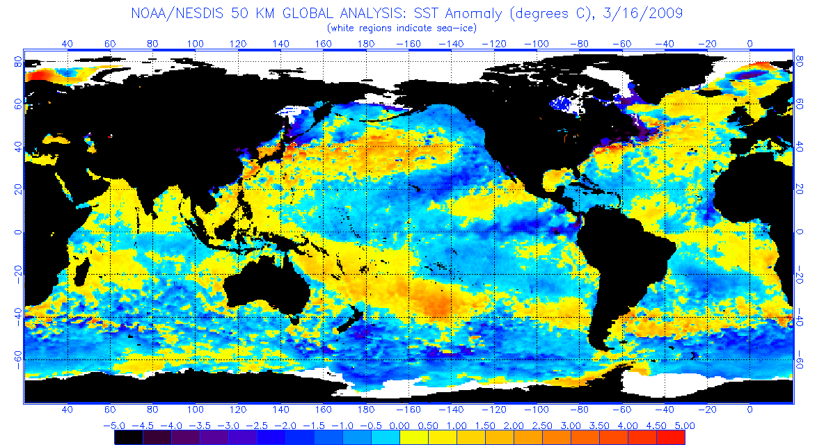
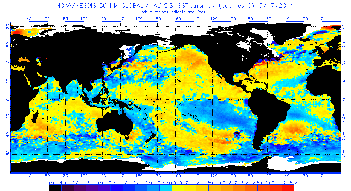
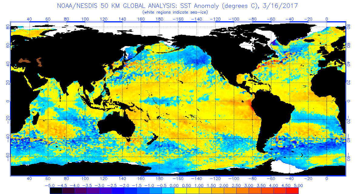
Hard for me to believe that any La-Nina will develop this year when you look at how warm the Nino regions are.
This is March 16, 2009 (moderate Nino year):
This is March 15, 2014 (weak Nino year):
And this is March 16, 2017:
This is March 16, 2009 (moderate Nino year):
This is March 15, 2014 (weak Nino year):
And this is March 16, 2017:
2 likes
RIP Kobe Bryant
-
Hurricaneman

- Category 5
- Posts: 7404
- Age: 45
- Joined: Tue Aug 31, 2004 3:24 pm
- Location: central florida
Re: ENSO Updates
Its true that the ENSO is heading for an El Nino but the atmosphere is not responding in kind, the atmosphere is more like a La Nina but thats why 2004 is an analog as that year had a similar thing going on with the atmosphere not responding to the El Nino but who knows what will happen by May or later
0 likes
Re: ENSO Updates
Well the atmosphere is in a more Nina like state because probably it's still lagging effects of the recent Nina. There's no Nino yet in the ocean to couple, so the atmosphere is just feeding back from what's been. Still need WWBs to start the changes which None is forecast the next 2 weeks.
1 likes
The above post and any post by Ntxw is NOT an official forecast and should not be used as such. It is just the opinion of the poster and may or may not be backed by sound meteorological data. It is NOT endorsed by any professional institution including Storm2k. For official information, please refer to NWS products.
Help support Storm2K!
Help support Storm2K!
Re: ENSO Updates
3.4 warmed to 0.3C this update. Nino 1+2 is 2.6C, nino 3 is 0.8C, and nino 4 is 0.0C
0 likes
The above post and any post by Ntxw is NOT an official forecast and should not be used as such. It is just the opinion of the poster and may or may not be backed by sound meteorological data. It is NOT endorsed by any professional institution including Storm2k. For official information, please refer to NWS products.
Help support Storm2K!
Help support Storm2K!
-
cycloneye
- Admin
- Posts: 149442
- Age: 69
- Joined: Thu Oct 10, 2002 10:54 am
- Location: San Juan, Puerto Rico
Re: ENSO Updates
Ntxw wrote:3.4 warmed to 0.3C this update. Nino 1+2 is 2.6C, nino 3 is 0.8C, and nino 4 is 0.0C
http://www.cpc.noaa.gov/products/analys ... ts-web.pdf
0 likes
Visit the Caribbean-Central America Weather Thread where you can find at first post web cams,radars
and observations from Caribbean basin members Click Here
and observations from Caribbean basin members Click Here
-
cycloneye
- Admin
- Posts: 149442
- Age: 69
- Joined: Thu Oct 10, 2002 10:54 am
- Location: San Juan, Puerto Rico
Re: ENSO: CPC Weekly update of 3/20/17: Nino 3.4 up to +0.3C / Nino 1+2 up to +2.6C
0 likes
Visit the Caribbean-Central America Weather Thread where you can find at first post web cams,radars
and observations from Caribbean basin members Click Here
and observations from Caribbean basin members Click Here
-
Kingarabian
- S2K Supporter
- Posts: 16361
- Joined: Sat Aug 08, 2009 3:06 am
- Location: Honolulu, Hawaii
Re: ENSO Updates
Something else has to be going on @ Nino 1+2. For all its volatility, it has sustained moderately warm if not strong values for nearly 2 months now.
0 likes
RIP Kobe Bryant
Re: ENSO Updates
Last burst of trades this week. Then warmer west u winds anomalies showing near Nino 3.4 region
1 likes
The above post and any post by Ntxw is NOT an official forecast and should not be used as such. It is just the opinion of the poster and may or may not be backed by sound meteorological data. It is NOT endorsed by any professional institution including Storm2k. For official information, please refer to NWS products.
Help support Storm2K!
Help support Storm2K!
Re: ENSO Updates
Kingarabian wrote:Something else has to be going on @ Nino 1+2. For all its volatility, it has sustained moderately warm if not strong values for nearly 2 months now.
Convection in this region can correlate with strong Caribbean shear
0 likes
The above post and any post by Ntxw is NOT an official forecast and should not be used as such. It is just the opinion of the poster and may or may not be backed by sound meteorological data. It is NOT endorsed by any professional institution including Storm2k. For official information, please refer to NWS products.
Help support Storm2K!
Help support Storm2K!
-
Hurricaneman
- Category 5
- Posts: 7404
- Age: 45
- Joined: Tue Aug 31, 2004 3:24 pm
- Location: central florida
Re: ENSO Updates
looks like the subsurface is seeing less positive anomalies which might indicate the El Nino might not come
http://www.cpc.ncep.noaa.gov/products/a ... zteq.shtml
And the SOI seems to be in the positive which would back up those claims
http://www.cpc.ncep.noaa.gov/products/a ... zteq.shtml
And the SOI seems to be in the positive which would back up those claims
0 likes
-
cycloneye
- Admin
- Posts: 149442
- Age: 69
- Joined: Thu Oct 10, 2002 10:54 am
- Location: San Juan, Puerto Rico
Re: ENSO Updates
0 likes
Visit the Caribbean-Central America Weather Thread where you can find at first post web cams,radars
and observations from Caribbean basin members Click Here
and observations from Caribbean basin members Click Here
Who is online
Users browsing this forum: No registered users and 184 guests