ENSO Updates (2007 thru 2023)
Moderator: S2k Moderators
Forum rules

The posts in this forum are NOT official forecasts and should not be used as such. They are just the opinion of the poster and may or may not be backed by sound meteorological data. They are NOT endorsed by any professional institution or STORM2K. For official information, please refer to products from the National Hurricane Center and National Weather Service.
-
Yellow Evan

- Professional-Met

- Posts: 16240
- Age: 27
- Joined: Fri Jul 15, 2011 12:48 pm
- Location: Henderson, Nevada/Honolulu, HI
- Contact:
Re: ENSO Updates
Given weekly SST's are near .5C, I honestly don't think an El Nino is too far off. People seem somewhat pessimistic but keep in mind that an east to west evolution works differently than west to east one. Precisely how- I'm not sure, as most east to west Ninos happened prior to crcia 1985, where records weren't very good.
3 likes
-
Kingarabian

- S2K Supporter

- Posts: 16361
- Joined: Sat Aug 08, 2009 3:06 am
- Location: Honolulu, Hawaii
Re: ENSO Updates
Yellow Evan wrote:Given weekly SST's are near .5C, I honestly don't think an El Nino is too far off. People seem somewhat pessimistic but keep in mind that an east to west evolution works differently than west to east one. Precisely how- I'm not sure, as most east to west Ninos happened prior to crcia 1985, where records weren't very good.
Yeah. Despite the trades being persistent, positive values have maintained themselves.
To add fuel to the Nino fire, the PDO has warmed for march, and it looks like we'll have a warm PDO for the restof the year.
For those talking about the cool pool below the surface, look behind it. Massive warm pool.
0 likes
RIP Kobe Bryant
-
Kingarabian
- S2K Supporter
- Posts: 16361
- Joined: Sat Aug 08, 2009 3:06 am
- Location: Honolulu, Hawaii


Re: ENSO Updates
There just isn't strong evidence for an El Nino yet though. Aside from neutral warm SST near the surface that's not enough for a true event. We saw an event abort with no subsurface and lack of WWBs in 2012. PDO is nothing cold like that year so a weak event is still possible to probable but there are not indicators in the ocean that says we are currently building an El Nino.
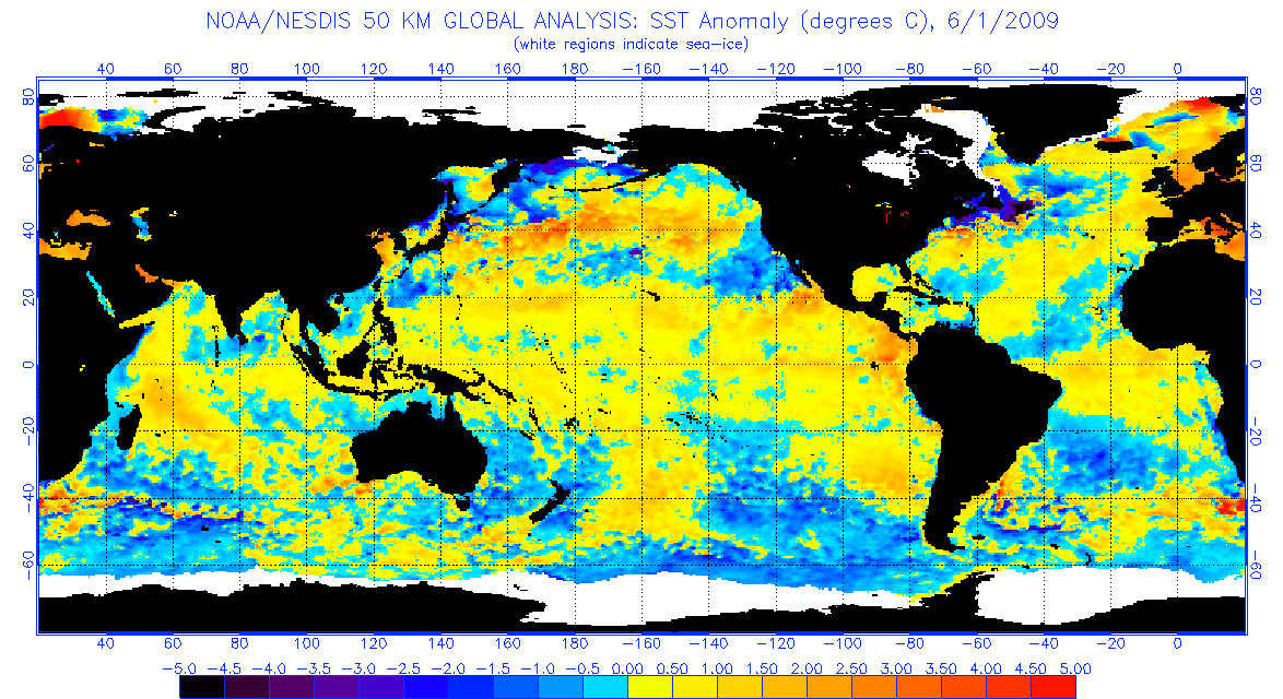
Even in 2009 there was already a deep, large warm pool lurking and when the winds switched in April and May the engine got rolling. It just didn't really take off until summer.

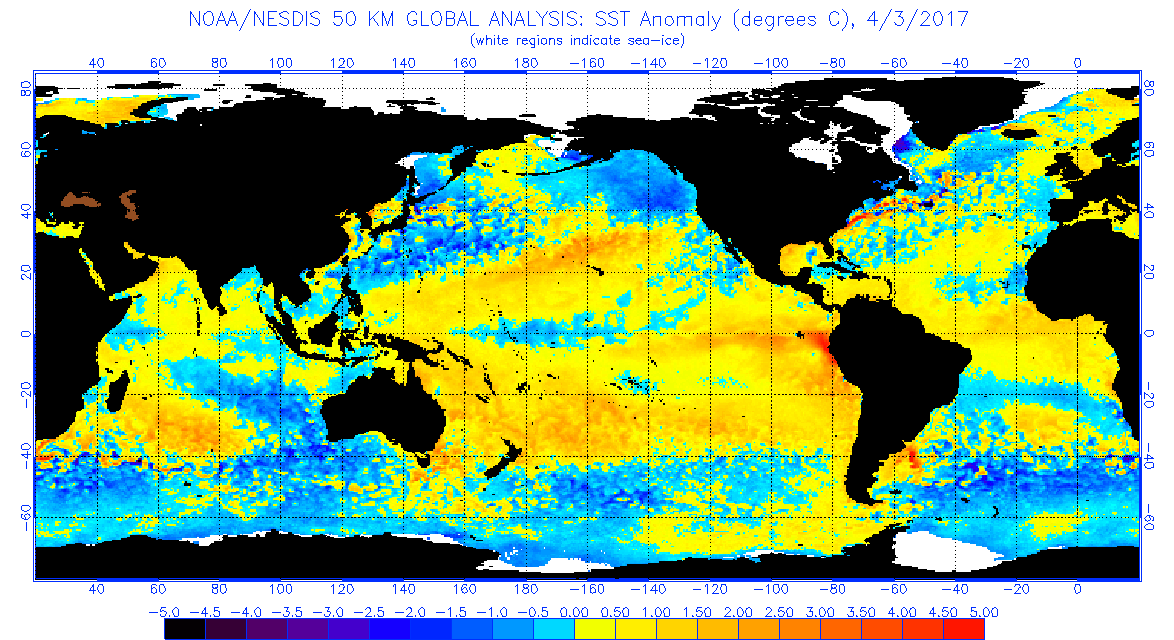
There is just no deep pool so far this year, in fact you could argue this look is trying to build another weak Nina below. However I do think this is a lag effect from stronger trades. While the warmth in the eastern basin is limited to near the surface. If the WWBs kicks in (there are yet no signs of one) then that could change. The longer we wait the longer it will take to build an ENSO event. I'm not expecting rapid WWB and subsurface coupling like 2015, but something has to get rolling besides the Feb MJO which was fleeting anyway.

Even in 2009 there was already a deep, large warm pool lurking and when the winds switched in April and May the engine got rolling. It just didn't really take off until summer.
There is just no deep pool so far this year, in fact you could argue this look is trying to build another weak Nina below. However I do think this is a lag effect from stronger trades. While the warmth in the eastern basin is limited to near the surface. If the WWBs kicks in (there are yet no signs of one) then that could change. The longer we wait the longer it will take to build an ENSO event. I'm not expecting rapid WWB and subsurface coupling like 2015, but something has to get rolling besides the Feb MJO which was fleeting anyway.
1 likes
The above post and any post by Ntxw is NOT an official forecast and should not be used as such. It is just the opinion of the poster and may or may not be backed by sound meteorological data. It is NOT endorsed by any professional institution including Storm2k. For official information, please refer to NWS products.
Help support Storm2K!
Re: ENSO Updates
NCDC PDO for March rose a little bit so we can probably expect JISAO to also, April will likely rise too. Nino or no, pretty evident the +PDO state is still the background force.
2 likes
The above post and any post by Ntxw is NOT an official forecast and should not be used as such. It is just the opinion of the poster and may or may not be backed by sound meteorological data. It is NOT endorsed by any professional institution including Storm2k. For official information, please refer to NWS products.
Help support Storm2K!
Help support Storm2K!
-
Kingarabian
- S2K Supporter
- Posts: 16361
- Joined: Sat Aug 08, 2009 3:06 am
- Location: Honolulu, Hawaii
Re: ENSO Updates
Ntxw wrote:NCDC PDO for March rose a little bit so we can probably expect JISAO to also, April will likely rise too. Nino or no, pretty evident the +PDO state is still the background force.
Yeah and it's easy to forget that the PDO has ENSO like effects. So even if this Nino fails to materialize, a warm PDO can be a negative factor for the Atlantic Hurricane season - especially if there's no La Nina to fight it off (like last season).
0 likes
RIP Kobe Bryant
-
cycloneye

- Admin

- Posts: 149442
- Age: 69
- Joined: Thu Oct 10, 2002 10:54 am
- Location: San Juan, Puerto Rico
Re: ENSO Updates
https://twitter.com/MJVentrice/status/850337651106381824
@MJVentrice
With MJO activity picking up, odds increase for a westerly wind burst over the West Pacific during the first week of May

@MJVentrice
With MJO activity picking up, odds increase for a westerly wind burst over the West Pacific during the first week of May
1 likes
Visit the Caribbean-Central America Weather Thread where you can find at first post web cams,radars
and observations from Caribbean basin members Click Here
and observations from Caribbean basin members Click Here
-
SouthFloridian92
- Tropical Storm

- Posts: 120
- Age: 33
- Joined: Tue Dec 11, 2012 4:50 pm
- Location: Sebring, Florida
-
Kingarabian
- S2K Supporter
- Posts: 16361
- Joined: Sat Aug 08, 2009 3:06 am
- Location: Honolulu, Hawaii
Re: ENSO Updates
Ntxw wrote:There just isn't strong evidence for an El Nino yet though. Aside from neutral warm SST near the surface that's not enough for a true event. We saw an event abort with no subsurface and lack of WWBs in 2012. PDO is nothing cold like that year so a weak event is still possible to probable but there are not indicators in the ocean that says we are currently building an El Nino.
Even in 2009 there was already a deep, large warm pool lurking and when the winds switched in April and May the engine got rolling. It just didn't really take off until summer.
There is just no deep pool so far this year, in fact you could argue this look is trying to build another weak Nina below. However I do think this is a lag effect from stronger trades. While the warmth in the eastern basin is limited to near the surface. If the WWBs kicks in (there are yet no signs of one) then that could change. The longer we wait the longer it will take to build an ENSO event. I'm not expecting rapid WWB and subsurface coupling like 2015, but something has to get rolling besides the Feb MJO which was fleeting anyway.
Do you see any evidence at the subsurface of a warm pool growing east to west as the CFS has been forecasting?

Looking at the current subsurface pool depictions, it appears to be that the area of warm water(pool?) @ 100W-85W (near Nino 3 and Nino 1+2) has strengthened and expanded west. Maybe the CFS forecast holds some merit.

0 likes
RIP Kobe Bryant
-
cycloneye
- Admin
- Posts: 149442
- Age: 69
- Joined: Thu Oct 10, 2002 10:54 am
- Location: San Juan, Puerto Rico
Re: ENSO Updates
1 likes
Visit the Caribbean-Central America Weather Thread where you can find at first post web cams,radars
and observations from Caribbean basin members Click Here
and observations from Caribbean basin members Click Here
-
Hurricaneman

- Category 5

- Posts: 7404
- Age: 45
- Joined: Tue Aug 31, 2004 3:24 pm
- Location: central florida
Re: ENSO Updates
According to tropical tidbits the ENSO 1/2 has dropped below 1 above normal and also the eastern part of ENSO 3 has dropped which is important and could lead to an El Niño madoki and also important things are the SOI, and EPAC MDR whether that continues to drop or starts to rise again
0 likes
-
Kingarabian
- S2K Supporter
- Posts: 16361
- Joined: Sat Aug 08, 2009 3:06 am
- Location: Honolulu, Hawaii

-
euro6208
Re: ENSO Updates
Modoki, Neutral, or Traditional, the WPAC looks to be on a rollercoaster again...
0 likes
Re: ENSO Updates
Kingarabian wrote:Do you see any evidence at the subsurface of a warm pool growing east to west as the CFS has been forecasting?
Warm pools don't grow from east to west. As SST's spreads from west to east the anomalies further east show greater +anomalies. What the CFSv2 is showing, portays the thermocline slope in the eastern basin depressing much more than normal
Much weakened trades are in the forecast. Perhaps this will lead to a WWB as the forecast get closer to view.

0 likes
The above post and any post by Ntxw is NOT an official forecast and should not be used as such. It is just the opinion of the poster and may or may not be backed by sound meteorological data. It is NOT endorsed by any professional institution including Storm2k. For official information, please refer to NWS products.
Help support Storm2K!
Help support Storm2K!
-
cycloneye
- Admin
- Posts: 149442
- Age: 69
- Joined: Thu Oct 10, 2002 10:54 am
- Location: San Juan, Puerto Rico
Re: ENSO Updates
0 likes
Visit the Caribbean-Central America Weather Thread where you can find at first post web cams,radars
and observations from Caribbean basin members Click Here
and observations from Caribbean basin members Click Here
-
cycloneye
- Admin
- Posts: 149442
- Age: 69
- Joined: Thu Oct 10, 2002 10:54 am
- Location: San Juan, Puerto Rico
Re: ENSO Updates
1 likes
Visit the Caribbean-Central America Weather Thread where you can find at first post web cams,radars
and observations from Caribbean basin members Click Here
and observations from Caribbean basin members Click Here
-
cycloneye
- Admin
- Posts: 149442
- Age: 69
- Joined: Thu Oct 10, 2002 10:54 am
- Location: San Juan, Puerto Rico
Re: ENSO Updates
0 likes
Visit the Caribbean-Central America Weather Thread where you can find at first post web cams,radars
and observations from Caribbean basin members Click Here
and observations from Caribbean basin members Click Here
Re: ENSO Updates
This week's reading should hold at 0.3C. only significant change is Nino 1+2 now down to 0.9C
0 likes
The above post and any post by Ntxw is NOT an official forecast and should not be used as such. It is just the opinion of the poster and may or may not be backed by sound meteorological data. It is NOT endorsed by any professional institution including Storm2k. For official information, please refer to NWS products.
Help support Storm2K!
Help support Storm2K!
-
cycloneye
- Admin
- Posts: 149442
- Age: 69
- Joined: Thu Oct 10, 2002 10:54 am
- Location: San Juan, Puerto Rico
Re: ENSO Updates
Remains at +0.3C and Nino 1+2 is down to +0.9C.
http://www.cpc.ncep.noaa.gov/products/a ... ts-web.pdf
http://www.cpc.ncep.noaa.gov/products/a ... ts-web.pdf
0 likes
Visit the Caribbean-Central America Weather Thread where you can find at first post web cams,radars
and observations from Caribbean basin members Click Here
and observations from Caribbean basin members Click Here
Who is online
Users browsing this forum: MarioProtVI and 273 guests