Strong Wave East of Windward Islands-(Is Invest 97L)

This is the general tropical discussion area. Anyone can take their shot at predicting a storms path.

Moderator: S2k Moderators

Forum rules

The posts in this forum are NOT official forecasts and should not be used as such. They are just the opinion of the poster and may or may not be backed by sound meteorological data. They are NOT endorsed by any professional institution or STORM2K. For official information, please refer to products from the National Hurricane Center and National Weather Service.

Help Support Storm2K
Message
Author
User avatar
Blown Away
S2K Supporter
S2K Supporter
Posts: 9876
Joined: Wed May 26, 2004 6:17 am

Re: Strong Tropical Wave East of Windward Islands-10%

#81 Postby Blown Away » Thu Jun 28, 2012 7:23 am

AHS2011 wrote:Oh, and I said 20% or 30% because the newest update mentioned "more concentrated".


I'm sure they want convection pesistence before getting too interested.

This is mostly an all or nothing board, when a big hurricane is heading for the States, this board is jumping, servers are smoking, and folks can get out of control! That being said, it's the best board going for quality info and entertainment when it comes to weather!! There is a core of folks, including me, that are addicted year around! :D
0 likes   
Hurricane Eye Experience: David 79, Irene 99, Frances 04, Jeanne 04, Wilma 05... EYE COMING MY WAY IN 2024…
Hurricane Brush Experience: Andrew 92, Erin 95, Floyd 99, Matthew 16, Irma 17, Ian 22, Nicole 22…

Aric Dunn
Category 5
Category 5
Posts: 21228
Age: 41
Joined: Sun Sep 19, 2004 9:58 pm
Location: Ready for the Chase.
Contact:

Re: Strong Tropical Wave East of Windward Islands-10%

#82 Postby Aric Dunn » Thu Jun 28, 2012 7:34 am

AHS2011 wrote:Oh, and I said 20% or 30% because the newest update mentioned "more concentrated".


well they might if the convection persists and does not fade and redevelop.
0 likes   
Note: If I make a post that is brief. Please refer back to previous posts for the analysis or reasoning. I do not re-write/qoute what my initial post said each time.
If there is nothing before... then just ask :)

Space & Atmospheric Physicist, Embry-Riddle Aeronautical University,
I believe the sky is falling...

User avatar
wxman57
Moderator-Pro Met
Moderator-Pro Met
Posts: 22512
Age: 66
Joined: Sat Jun 21, 2003 8:06 pm
Location: Houston, TX (southwest)

Re: Strong Tropical Wave East of Windward Islands-10%

#83 Postby wxman57 » Thu Jun 28, 2012 7:48 am

Satellite indicates the convection is waning now. Just a temporary flare-up. Look elsewhere for Ernesto. Maybe in August...
0 likes   

Aric Dunn
Category 5
Category 5
Posts: 21228
Age: 41
Joined: Sun Sep 19, 2004 9:58 pm
Location: Ready for the Chase.
Contact:

Re: Strong Tropical Wave East of Windward Islands-10%

#84 Postby Aric Dunn » Thu Jun 28, 2012 8:02 am

well besides its less defined than yesterday in terms of rotation. it has a good moisture envelope.

just does not have the low level convergence to maintain convection.

Image
0 likes   
Note: If I make a post that is brief. Please refer back to previous posts for the analysis or reasoning. I do not re-write/qoute what my initial post said each time.
If there is nothing before... then just ask :)

Space & Atmospheric Physicist, Embry-Riddle Aeronautical University,
I believe the sky is falling...

canes04
Category 1
Category 1
Posts: 297
Joined: Sat May 22, 2004 5:41 pm
Location: Miami, FL

Re: Strong Tropical Wave East of Windward Islands-10%

#85 Postby canes04 » Thu Jun 28, 2012 9:18 am

I'm surprised of the lack of attention this is getting. There is some potential with this system.
Actually the convection appears to be maintaining itself this morning. I would bump it up to 20% at 2pm.
0 likes   

User avatar
wxman57
Moderator-Pro Met
Moderator-Pro Met
Posts: 22512
Age: 66
Joined: Sat Jun 21, 2003 8:06 pm
Location: Houston, TX (southwest)

Re: Strong Tropical Wave East of Windward Islands-10%

#86 Postby wxman57 » Thu Jun 28, 2012 9:39 am

canes04 wrote:I'm surprised of the lack of attention this is getting. There is some potential with this system.
Actually the convection appears to be maintaining itself this morning. I would bump it up to 20% at 2pm.


Convection is quite minimal and it's heading into a region of relatively high shear within 48 hrs. I'd say close to 0% chance of development within 48 hrs.
0 likes   

User avatar
Cainer
Tropical Storm
Tropical Storm
Posts: 188
Age: 33
Joined: Mon May 05, 2008 3:26 pm
Location: Yarmouth, Nova Scotia

Re: Strong Tropical Wave East of Windward Islands-10%

#87 Postby Cainer » Thu Jun 28, 2012 9:44 am

wxman57 wrote:
canes04 wrote:I'm surprised of the lack of attention this is getting. There is some potential with this system.
Actually the convection appears to be maintaining itself this morning. I would bump it up to 20% at 2pm.


Convection is quite minimal and it's heading into a region of relatively high shear within 48 hrs. I'd say close to 0% chance of development within 48 hrs.


wxman57, do you think it has better chances once it reaches the Caribbean?
0 likes   

User avatar
SFLcane
S2K Supporter
S2K Supporter
Posts: 9627
Age: 46
Joined: Sat Jun 05, 2010 1:44 pm
Location: Lake Worth Florida

Re: Strong Tropical Wave East of Windward Islands-10%

#88 Postby SFLcane » Thu Jun 28, 2012 9:46 am

wxman57 wrote:Satellite indicates the convection is waning now. Just a temporary flare-up. Look elsewhere for Ernesto. Maybe in August...


Maybe in 2013...if things turn out like this. http://www.cpc.ncep.noaa.gov/products/C ... o34Mon.gif :(
0 likes   

User avatar
Ivanhater
Storm2k Moderator
Storm2k Moderator
Posts: 10859
Age: 37
Joined: Fri Jul 01, 2005 8:25 am
Location: Pensacola

Re: Strong Tropical Wave East of Windward Islands-10%

#89 Postby Ivanhater » Thu Jun 28, 2012 9:46 am

Regardless if this develops or not, that is a strong wave for this time of year. This season has not behaved like many of the forecasters have thought thus far.
0 likes   
Michael

User avatar
Riptide
Category 2
Category 2
Posts: 753
Age: 32
Joined: Fri Jul 23, 2010 3:33 pm
Location: Cape May, New Jersey
Contact:

Re: Strong Tropical Wave East of Windward Islands-10%

#90 Postby Riptide » Thu Jun 28, 2012 9:51 am

SFLcane wrote:
wxman57 wrote:Satellite indicates the convection is waning now. Just a temporary flare-up. Look elsewhere for Ernesto. Maybe in August...


Maybe in 2013...if things turn out like this. http://www.cpc.ncep.noaa.gov/products/C ... o34Mon.gif :(

CFS is never 100 % accurate; and more importantly current statistics show that the 2012 season will feature an average or above average amount of activity.
0 likes   

User avatar
SFLcane
S2K Supporter
S2K Supporter
Posts: 9627
Age: 46
Joined: Sat Jun 05, 2010 1:44 pm
Location: Lake Worth Florida

Re: Strong Tropical Wave East of Windward Islands-10%

#91 Postby SFLcane » Thu Jun 28, 2012 10:48 am

Ivanhater wrote:Regardless if this develops or not, that is a strong wave for this time of year. This season has not behaved like many of the forecasters have thought thus far.


Other then ugly debby this season thus far has been all about hybrid/subtropical type systems. That wave currently in central atl is unlikely to develope. Concur with wxman maybe mid august before we something again.
0 likes   

floridasun78
Category 5
Category 5
Posts: 3755
Joined: Sun May 17, 2009 10:16 pm
Location: miami fl

#92 Postby floridasun78 » Thu Jun 28, 2012 11:18 am

i think before aug we see next system no one can say it be untill aug no one i see one in july i hope you all say aug will come to board say i was wrong even wxman
0 likes   

User avatar
SouthFloridawx
S2K Supporter
S2K Supporter
Posts: 8344
Age: 45
Joined: Tue Jul 26, 2005 1:16 am
Location: Sarasota, FL
Contact:

Re: Strong Tropical Wave East of Windward Islands-10%

#93 Postby SouthFloridawx » Thu Jun 28, 2012 11:23 am

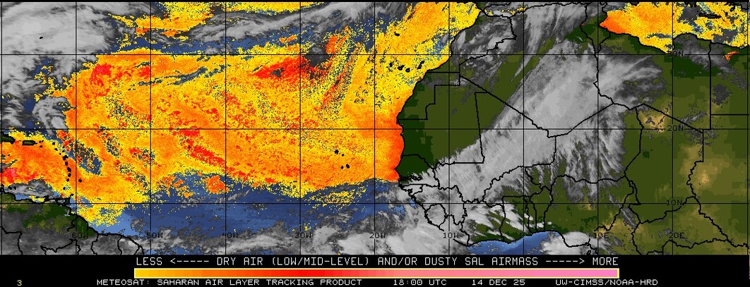
Not much wind shear and SAL is not too bad either.

Image

Image
0 likes   

User avatar
Gustywind
Category 5
Category 5
Posts: 12334
Joined: Mon Sep 03, 2007 7:29 am
Location: Baie-Mahault, GUADELOUPE

#94 Postby Gustywind » Thu Jun 28, 2012 11:26 am

Sat pic of this twave continuing its travels to the west...
Image
0 likes   

User avatar
ConvergenceZone
Category 5
Category 5
Posts: 4833
Joined: Fri Jul 29, 2005 1:40 am
Location: Northern California

Re: Strong Tropical Wave East of Windward Islands-10%

#95 Postby ConvergenceZone » Thu Jun 28, 2012 11:30 am

wxman57 wrote:Satellite indicates the convection is waning now. Just a temporary flare-up. Look elsewhere for Ernesto. Maybe in August...


WXMAN57, Wow! That's quite a statement from you, so you think we will go the entire month of July without the next tropical storm forming huh?... Any reasoning behind your prediction?
Just curious...
0 likes   

User avatar
Gustywind
Category 5
Category 5
Posts: 12334
Joined: Mon Sep 03, 2007 7:29 am
Location: Baie-Mahault, GUADELOUPE

#96 Postby Gustywind » Thu Jun 28, 2012 11:47 am

Image
0 likes   

Weatherfreak000

Re: Strong Tropical Wave East of Windward Islands-10%

#97 Postby Weatherfreak000 » Thu Jun 28, 2012 12:10 pm

ConvergenceZone wrote:
wxman57 wrote:Satellite indicates the convection is waning now. Just a temporary flare-up. Look elsewhere for Ernesto. Maybe in August...


WXMAN57, Wow! That's quite a statement from you, so you think we will go the entire month of July without the next tropical storm forming huh?... Any reasoning behind your prediction?
Just curious...


It's not a bad prediction with el nino tightening its grip. Wx47 in my history here tends to suggest this often, perhaps he just doesn't want to have to work as much early season. lol.


That being said, convection continues to wane, if this thing has a shot it has to keep pulsing until it makes it to the Caribbean.
0 likes   

User avatar
TheBurn
Category 2
Category 2
Posts: 524
Joined: Thu Jul 28, 2005 4:00 pm
Location: Rincon, PR

Re: Strong Tropical Wave East of Windward Islands-10%

#98 Postby TheBurn » Thu Jun 28, 2012 12:42 pm

17:15 UTC MPE

Image
0 likes   

rockyman
Category 5
Category 5
Posts: 1967
Joined: Thu Jun 26, 2003 12:24 pm
Location: Dauphin Island, AL

#99 Postby rockyman » Thu Jun 28, 2012 1:13 pm

TROPICAL WEATHER OUTLOOK
NWS NATIONAL HURRICANE CENTER MIAMI FL
200 PM EDT THU JUN 28 2012

FOR THE NORTH ATLANTIC...CARIBBEAN SEA AND THE GULF OF MEXICO...

2. SHOWERS AND THUNDERSTORMS ASSOCIATED WITH A TROPICAL WAVE LOCATED
ABOUT 1250 MILES EAST OF THE WINDWARD ISLANDS REMAIN DISORGANIZED.
DEVELOPMENT...IF ANY...SHOULD BE SLOW TO OCCUR AS THE WAVE MOVES
GENERALLY WESTWARD AT 10 TO 15 MPH. THIS SYSTEM HAS A LOW
CHANCE...10 PERCENT...OF BECOMING A TROPICAL CYCLONE DURING THE
NEXT 48 HOURS.
0 likes   

Aric Dunn
Category 5
Category 5
Posts: 21228
Age: 41
Joined: Sun Sep 19, 2004 9:58 pm
Location: Ready for the Chase.
Contact:

#100 Postby Aric Dunn » Thu Jun 28, 2012 1:35 pm

I did not think there was. but there is still what looks like a LLC small but it was under that deep convective burst from this morning... you can clearly see in the loop now on the eastern side.

http://rammb.cira.colostate.edu/ramsdis ... _floater_2

or here.

http://wwwghcc.msfc.nasa.gov/GOES/goeseasthurr.html
0 likes   
Note: If I make a post that is brief. Please refer back to previous posts for the analysis or reasoning. I do not re-write/qoute what my initial post said each time.
If there is nothing before... then just ask :)

Space & Atmospheric Physicist, Embry-Riddle Aeronautical University,
I believe the sky is falling...


Return to “Talkin' Tropics”

Who is online

Users browsing this forum: cainjamin, jgh and 54 guests