Tropical Wave over the SE Bahamas (Is INVEST 91L)
Moderator: S2k Moderators
Forum rules

The posts in this forum are NOT official forecasts and should not be used as such. They are just the opinion of the poster and may or may not be backed by sound meteorological data. They are NOT endorsed by any professional institution or STORM2K. For official information, please refer to products from the National Hurricane Center and National Weather Service.
-
CyclonicFury

- Category 5

- Posts: 2032
- Age: 27
- Joined: Sun Jul 02, 2017 12:32 pm
- Location: NC
- Contact:
Re: Tropical Wave in East Atlantic
This may have gone "poof" today but it's possible this wave will still have to be watched when it reaches the western Atlantic in about 8 days. It will likely be removed from the TWO and re-added some time next week. It's likely going to remain mostly devoid of deep convection until the time it approaches the Lesser Antilles.
2 likes
NCSU B.S. in Meteorology Class of 2021. Tropical weather blogger at http://www.cyclonicfury.com. My forecasts and thoughts are NOT official, for official forecasts please consult the National Hurricane Center.
Re: Tropical Wave in East Atlantic
CyclonicFury wrote:This may have gone "poof" today but it's possible this wave will still have to be watched when it reaches the western Atlantic in about 8 days. It will likely be removed from the TWO and re-added some time next week. It's likely going to remain mostly devoid of deep convection until the time it approaches the Lesser Antilles.
The 0Z CMC Canadian takes it and latches on on Aug 31st to this in the Bahamas and takes a hurricane into Miami on Labor day weekend. It's the Canadian, so I'd bet against it happening 3 times over.
0 likes
-
Hypercane_Kyle

- Category 5
- Posts: 3465
- Joined: Sat Mar 07, 2015 7:58 pm
- Location: Cape Canaveral, FL
Re: Tropical Wave in East Atlantic
BobHarlem wrote:CyclonicFury wrote:This may have gone "poof" today but it's possible this wave will still have to be watched when it reaches the western Atlantic in about 8 days. It will likely be removed from the TWO and re-added some time next week. It's likely going to remain mostly devoid of deep convection until the time it approaches the Lesser Antilles.
The 0Z CMC Canadian takes it and latches on on Aug 31st to this in the Bahamas and takes a hurricane into Miami on Labor day weekend. It's the Canadian, so I'd bet against it happening 3 times over.
I think it's possible. The Canadian model isn't the best but it's significantly improved over the past few years as far as not having loads of ghost storms.
1 likes
My posts are my own personal opinion, defer to the National Hurricane Center (NHC) and other NOAA products for decision making during hurricane season.
-
cycloneye

- Admin

- Posts: 149369
- Age: 69
- Joined: Thu Oct 10, 2002 10:54 am
- Location: San Juan, Puerto Rico
Re: Tropical Wave in East Atlantic
Even thou is possible,this wave will probably not me mentioned in the next few TWO's,the thread will remain open for the peeps to post comments about the wave as it moves thru the Atlantic. More important are those who live in the Leeward and Windward Islands,BVI,USVI and Puerto Rico to post reports about the effects of wave as it moves thru the Caribbean Islands. There is the possibility that this wave may have some better conditions way downstream and NHC may have it back at the TWO and this is the reason this thread will remain open until of course it gets the invest designation. (If it gets tagged at all)
5 likes
Visit the Caribbean-Central America Weather Thread where you can find at first post web cams,radars
and observations from Caribbean basin members Click Here
and observations from Caribbean basin members Click Here
-
gatorcane

- S2K Supporter

- Posts: 23708
- Age: 48
- Joined: Sun Mar 13, 2005 3:54 pm
- Location: Boca Raton, FL
Re: Tropical Wave in East Atlantic
cycloneye wrote:Even thou is possible,this wave will probably not me mentioned in the next few TWO's,the thread will remain open for the peeps to post comments about the wave as it moves thru the Atlantic. More important are those who live in the Leeward and Windward Islands,BVI,USVI and Puerto Rico to post reports about the effects of wave as it moves thru the Caribbean Islands. There is the possibility that this wave may have some better conditions way downstream and NHC may have it back at the TWO and this is the reason this thread will remain open until of course it gets the invest designation. (If it gets tagged at all)
I think that’s a good idea. I think this is one wave that could get brought back by the NHC as conditions looks like they could be favorable down the road if it gets into the SW Atlantic/Bahamas.
1 likes
-
Gustywind

- Category 5
- Posts: 12334
- Joined: Mon Sep 03, 2007 7:29 am
- Location: Baie-Mahault, GUADELOUPE
Re: Tropical Wave in East Atlantic
cycloneye wrote:Even thou is possible,this wave will probably not me mentioned in the next few TWO's,the thread will remain open for the peeps to post comments about the wave as it moves thru the Atlantic. More important are those who live in the Leeward and Windward Islands,BVI,USVI and Puerto Rico to post reports about the effects of wave as it moves thru the Caribbean Islands. There is the possibility that this wave may have some better conditions way downstream and NHC may have it back at the TWO and this is the reason this thread will remain open until of course it gets the invest designation. (If it gets tagged at all)
That's an excellent post and fully agree with your opinion, congrats
1 likes
-
jasons2k

- Storm2k Executive
- Posts: 8290
- Age: 52
- Joined: Wed Jul 06, 2005 12:32 pm
- Location: The Woodlands, TX
Re: Tropical Wave in East Atlantic
If - IF - it does make it all the way to the Islands or Bahamas, it will need to be watched very closely. Conditions look they will become more conducive for development and the Atlantic Ridge will be stout. This one may be westward bound before it's over.
3 likes
-
cycloneye
- Admin
- Posts: 149369
- Age: 69
- Joined: Thu Oct 10, 2002 10:54 am
- Location: San Juan, Puerto Rico
Re: Tropical Wave in East Atlantic
2 PM TWD of wave:
A tropical wave is off the coast of W Africa along 18W from 04N-
20N, moving westward at 15 kt. The wave is in a moist environment
and has 700 mb support. Scattered showers are from 11N-21N between
16W-26W.
20N, moving westward at 15 kt. The wave is in a moist environment
and has 700 mb support. Scattered showers are from 11N-21N between
16W-26W.
0 likes
Visit the Caribbean-Central America Weather Thread where you can find at first post web cams,radars
and observations from Caribbean basin members Click Here
and observations from Caribbean basin members Click Here
-
cycloneye
- Admin
- Posts: 149369
- Age: 69
- Joined: Thu Oct 10, 2002 10:54 am
- Location: San Juan, Puerto Rico
Re: Tropical Wave in East Atlantic
This is the Canadian (CMC) that has this wave developing and tracks to GOM as a strong Tropical Storm but is the CMC.

0 likes
Visit the Caribbean-Central America Weather Thread where you can find at first post web cams,radars
and observations from Caribbean basin members Click Here
and observations from Caribbean basin members Click Here
-
cycloneye
- Admin
- Posts: 149369
- Age: 69
- Joined: Thu Oct 10, 2002 10:54 am
- Location: San Juan, Puerto Rico
Re: Tropical Wave in East Atlantic
No surprise.
Tropical Weather Outlook
NWS National Hurricane Center Miami FL
200 PM EDT Fri Aug 24 2018
For the North Atlantic...Caribbean Sea and the Gulf of Mexico:
Tropical cyclone formation is not expected during the next 5 days.
$$
Forecaster Berg
NWS National Hurricane Center Miami FL
200 PM EDT Fri Aug 24 2018
For the North Atlantic...Caribbean Sea and the Gulf of Mexico:
Tropical cyclone formation is not expected during the next 5 days.
$$
Forecaster Berg
0 likes
Visit the Caribbean-Central America Weather Thread where you can find at first post web cams,radars
and observations from Caribbean basin members Click Here
and observations from Caribbean basin members Click Here
-
wxGuy
Re: Tropical Wave in East Atlantic
cycloneye wrote:This is the Canadian (CMC) that has this wave developing and tracks to GOM as a strong Tropical Storm but is the CMC.
CMC is on to something
0 likes

Re: Tropical Wave in East Atlantic
Even a tropical storm would be harsh for many in the Keys as lots are still recovering from Irma.
0 likes
Re: Tropical Wave in West Africa
stormlover2013 wrote:and the ridge is stout
Yeah, I'm not liking this at all. If a system does develop it isn't recurving
0 likes

Re: Tropical Wave in East Atlantic
For the first time 18z GFS develops this in the Gulf and brings it in over Louisiana.

1 likes
The following post is NOT an official forecast and should not be used as such. It is just the opinion of the poster and may or may not be backed by sound meteorological data. It is NOT endorsed by any professional institution including storm2k.org For Official Information please refer to the NHC and NWS products.
-
cycloneye
- Admin
- Posts: 149369
- Age: 69
- Joined: Thu Oct 10, 2002 10:54 am
- Location: San Juan, Puerto Rico
Re: Tropical Wave in East Atlantic
8 PM TWD:
A tropical wave is offshore the coast of Africa near 19W from
05N to 20N, moving westward at 15 kt. The wave is in a moist
environment, and is supported by 700 mb troughing. Scattered
moderate convection is within 120 nm west of its axis from 05N to
07N. Scattered moderate convection is just inland the coast of
Africa within 30 nm of 14N16W.
05N to 20N, moving westward at 15 kt. The wave is in a moist
environment, and is supported by 700 mb troughing. Scattered
moderate convection is within 120 nm west of its axis from 05N to
07N. Scattered moderate convection is just inland the coast of
Africa within 30 nm of 14N16W.
0 likes
Visit the Caribbean-Central America Weather Thread where you can find at first post web cams,radars
and observations from Caribbean basin members Click Here
and observations from Caribbean basin members Click Here
-
cycloneye
- Admin
- Posts: 149369
- Age: 69
- Joined: Thu Oct 10, 2002 10:54 am
- Location: San Juan, Puerto Rico
Re: Tropical Wave in East Atlantic
cycloneye wrote:Even thou is possible,this wave will probably not me mentioned in the next few TWO's,the thread will remain open for the peeps to post comments about the wave as it moves thru the Atlantic. More important are those who live in the Leeward and Windward Islands,BVI,USVI and Puerto Rico to post reports about the effects of wave as it moves thru the Caribbean Islands. There is the possibility that this wave may have some better conditions way downstream and NHC may have it back at the TWO and this is the reason this thread will remain open until of course it gets the invest designation. (If it gets tagged at all)
Adding to my earlier comment about letting this thread open,I have to say the models are hinting downstream that something may pop from this wave and that is another reason to mantain the thread running.
1 likes
Visit the Caribbean-Central America Weather Thread where you can find at first post web cams,radars
and observations from Caribbean basin members Click Here
and observations from Caribbean basin members Click Here
-
Hypercane_Kyle
- Category 5
- Posts: 3465
- Joined: Sat Mar 07, 2015 7:58 pm
- Location: Cape Canaveral, FL
Re: Tropical Wave in East Atlantic
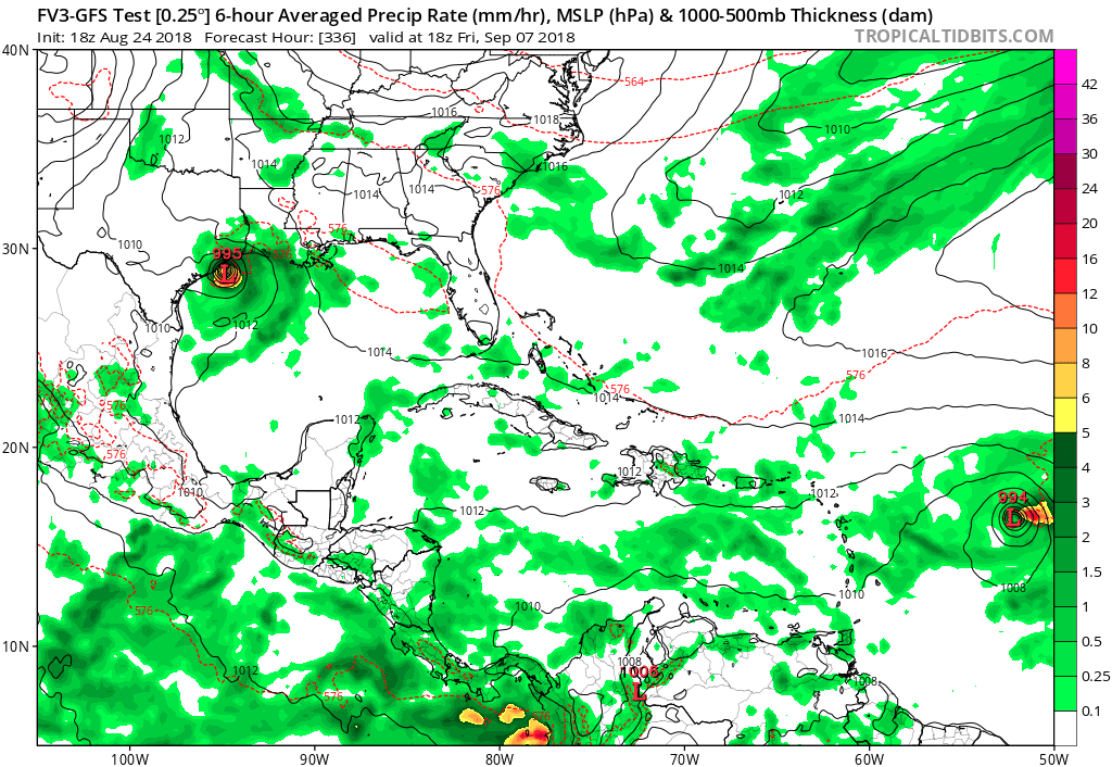
Both the FV3-GFS and operational GFS show development of this system once it reaches the GOMEX in 10-12 days.
1 likes
My posts are my own personal opinion, defer to the National Hurricane Center (NHC) and other NOAA products for decision making during hurricane season.
-
gatorcane
- S2K Supporter
- Posts: 23708
- Age: 48
- Joined: Sun Mar 13, 2005 3:54 pm
- Location: Boca Raton, FL
Re: Tropical Wave in East Atlantic
Hypercane_Kyle wrote:Both the FV3-GFS and operational GFS show development of this system once it reaches the GOMEX in 10-12 days.
Saved image:
0 likes
-
gatorcane
- S2K Supporter
- Posts: 23708
- Age: 48
- Joined: Sun Mar 13, 2005 3:54 pm
- Location: Boca Raton, FL
Re: Tropical Wave in East Atlantic
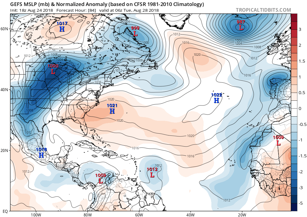
Looks like the 18Z GFS ensembles are a little bit more enthusiastic as it approaches the Lesser Antilles:
1 likes
-
Socalhurcnegirl227
- Category 1

- Posts: 267
- Age: 37
- Joined: Mon Jun 06, 2016 6:39 pm
- Location: Santa Barbara, CA
Re: Tropical Wave in East Atlantic
gatorcane wrote:Hypercane_Kyle wrote:Both the FV3-GFS and operational GFS show development of this system once it reaches the GOMEX in 10-12 days.
Saved image:
also a nice 994mb low east of antilles as well
0 likes
"I'm a wandress, i'm a one night stand,
dont belong to no city, dont belong to no man
i'm the violence in the pouring rain,
I'm a hurricane"
dont belong to no city, dont belong to no man
i'm the violence in the pouring rain,
I'm a hurricane"
Who is online
Users browsing this forum: kevin and 123 guests