Tropical Wave in the Eastern Atlantic (Is Invest 96L)
Moderator: S2k Moderators
Forum rules

The posts in this forum are NOT official forecasts and should not be used as such. They are just the opinion of the poster and may or may not be backed by sound meteorological data. They are NOT endorsed by any professional institution or STORM2K. For official information, please refer to products from the National Hurricane Center and National Weather Service.
-
TampaWxLurker
- Tropical Storm

- Posts: 196
- Joined: Thu Aug 01, 2024 8:20 am
Re: Tropical Wave in the Eastern Atlantic
GFS has it basically stalling out in the Bahamas for a few days so far on the run.
0 likes
-
DorkyMcDorkface

- Category 5

- Posts: 1012
- Age: 28
- Joined: Mon Sep 30, 2019 1:32 pm
- Location: Mid-Atlantic
Re: Tropical Wave in the Eastern Atlantic
I believe it's back on the UKMET:
NEW TROPICAL CYCLONE FORECAST TO DEVELOP AFTER 138 HOURS
FORECAST POSITION AT T+138 : 27.4N 58.1W
LEAD CENTRAL MAXIMUM WIND
VERIFYING TIME TIME POSITION PRESSURE (MB) SPEED (KNOTS)
-------------- ---- -------- ------------- -------------
1200UTC 11.08.2025 144 28.5N 58.4W 1014 32
0000UTC 12.08.2025 156 30.3N 57.9W 1013 32
1200UTC 12.08.2025 168 32.7N 56.7W 1008 49
1 likes
Please note the thoughts expressed by this account are solely those of the user and are from a hobbyist perspective. For more comprehensive analysis, consult an actual professional meteorologist or meteorological agency.
Floyd 1999 | Isabel 2003 | Hanna 2008 | Irene 2011 | Sandy 2012 | Isaias 2020
-
TampaWxLurker
- Tropical Storm
- Posts: 196
- Joined: Thu Aug 01, 2024 8:20 am
Re: Tropical Wave in the Eastern Atlantic
GFS shows strong TS/weak Cat 1 into Cape Canaveral (980 mb at landfall) 270 hours out, then riding up or just inside the coast to Jacksonville.
1 likes

Re: Tropical Wave in the Eastern Atlantic
2 PM:
A tropical wave over the far eastern tropical Atlantic is currently
producing a disorganized area of showers and thunderstorms.
Environmental conditions are forecast to be conducive for gradual
development during the next few days, and a tropical depression
could form late this week or over the weekend as the system moves
generally west-northwestward across the central tropical or
subtropical Atlantic.
* Formation chance through 48 hours...low...near 0 percent.
* Formation chance through 7 days...medium...50 percent.
0 likes
Re: Tropical Wave in the Eastern Atlantic
The 12Z Euro like recent runs has this as no more than a weak sfc low and then recurves the weak disturbance safely well out in the ocean. So, it is totally disagreeing with the GFS’s FL hit.
3 likes
Personal Forecast Disclaimer:
The posts in this forum are NOT official forecasts and should not be used as such. They are just the opinion of the poster and may or may not be backed by sound meteorological data. They are NOT endorsed by any professional institution or storm2k.org. For official information, please refer to the NHC and NWS products.
The posts in this forum are NOT official forecasts and should not be used as such. They are just the opinion of the poster and may or may not be backed by sound meteorological data. They are NOT endorsed by any professional institution or storm2k.org. For official information, please refer to the NHC and NWS products.
-
WaveBreaking

- Category 2

- Posts: 722
- Joined: Sun Jun 30, 2024 11:33 am
- Location: US
Re: Tropical Wave in the Eastern Atlantic
12Z GEFS also agrees with the latest Euro. Weaker members than the 6Z run and more OTS tracks.

2 likes
I am NOT a professional meteorologist, so take all of my posts with a grain of salt. My opinions are mine and mine alone.
Re: Tropical Wave in the Eastern Atlantic
WaveBreaking wrote:12Z GEFS also agrees with the latest Euro. Weaker members than the 6Z run and more OTS tracks.
https://www.weathernerds.org/models/v3.0/gefs/sessions/gefs_2025-08-05-12Z_144_50_258_0_350_MSLP_Surface_tracks_lows.png
Thanks. The 12Z EPS also agrees with the Euro (op and AI) and the GEFS regarding having little from this AOI. That’s a huge change from Friday, when it had ~50% of its members with a TC and with a good portion threatening the Caribbean/Bahamas/Conus from this lead AEW.
1 likes
Personal Forecast Disclaimer:
The posts in this forum are NOT official forecasts and should not be used as such. They are just the opinion of the poster and may or may not be backed by sound meteorological data. They are NOT endorsed by any professional institution or storm2k.org. For official information, please refer to the NHC and NWS products.
The posts in this forum are NOT official forecasts and should not be used as such. They are just the opinion of the poster and may or may not be backed by sound meteorological data. They are NOT endorsed by any professional institution or storm2k.org. For official information, please refer to the NHC and NWS products.
-
Blown Away

- S2K Supporter

- Posts: 10253
- Joined: Wed May 26, 2004 6:17 am
Re: Tropical Wave in the Eastern Atlantic
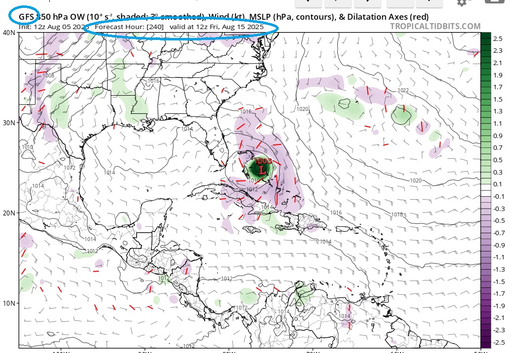
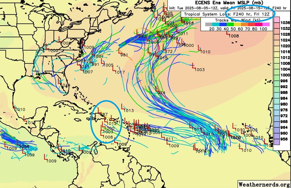
Maybe a group of the 12z ECENS see the same pattern, just slower, than the Operational GFS? I noticed the 12z GFS stalled/wobbled just before hour 240, maybe this is the model stating to correct being too fast? The 12z GEFS/ECENS still not to excited to match the GFS Operational. Something to watch in future GFS/GEFS/ECENS runs. JMHO...
0 likes
Hurricane Eye Experience: David 79, Irene 99, Frances 04, Jeanne 04, Wilma 05… Hurricane Brush Experience: Andrew 92, Erin 95, Floyd 99, Matthew 16, Irma 17, Ian 22, Nicole 22…
-
floridasun
- Tropical Storm
- Posts: 245
- Joined: Tue Sep 14, 2021 3:59 pm
Re: Tropical Wave in the Eastern Atlantic
been looking at models runs none got mind set how strong were going we days watch see if become ts or Hurr it waits and see game
0 likes
-
StormWeather

- Category 1

- Posts: 476
- Joined: Wed Jun 05, 2024 2:34 pm
Re: Tropical Wave in the Eastern Atlantic
I personally worry that this could be a sleeper wave, that it’s development could sneak up on us.
3 likes
Just an average cyclone tracker
The posts in this forum are NOT official forecasts and should not be used as such. They are just the opinion of the poster and may or may not be backed by sound meteorological data. They are NOT endorsed by any professional institution or storm2k.org. For official information, please refer to the NHC and NWS products
The posts in this forum are NOT official forecasts and should not be used as such. They are just the opinion of the poster and may or may not be backed by sound meteorological data. They are NOT endorsed by any professional institution or storm2k.org. For official information, please refer to the NHC and NWS products

Re: Tropical Wave in the Eastern Atlantic
StormWeather wrote:I personally worry that this could be a sleeper wave, that it’s development could sneak up on us.
Southeast coast of Florida has been lucky avoiding major hurricanes since Jeanne 21 years ago, and Andrew 33 years ago. Historically South Florida should expect a major hurricane every 9 years, people are not prepared for a major and it would be a nightmare.
2 likes
Re: Tropical Wave in the Eastern Atlantic
1. The GFS continues as of today’s Happy Hour run to not safely recurve this as it grazes the Conus E coast from NC to ME followed by a direct hit on Nova Scotia. The storm then goes into Newfoundland.
2. The 12Z JMA once again also doesn’t recurve this. It has it just N of PR moving WNW at the end (192 hrs).
2. The 12Z JMA once again also doesn’t recurve this. It has it just N of PR moving WNW at the end (192 hrs).
1 likes
Personal Forecast Disclaimer:
The posts in this forum are NOT official forecasts and should not be used as such. They are just the opinion of the poster and may or may not be backed by sound meteorological data. They are NOT endorsed by any professional institution or storm2k.org. For official information, please refer to the NHC and NWS products.
The posts in this forum are NOT official forecasts and should not be used as such. They are just the opinion of the poster and may or may not be backed by sound meteorological data. They are NOT endorsed by any professional institution or storm2k.org. For official information, please refer to the NHC and NWS products.
Re: Tropical Wave in the Eastern Atlantic
LarryWx wrote:1. The GFS continues as of today’s Happy Hour run to not safely recurve this as it grazes the Conus E coast from NC to ME followed by a direct hit on Nova Scotia. The storm then goes into Newfoundland.
2. The 12Z JMA once again also doesn’t recurve this. It has it just N of PR moving WNW at the end (192 hrs).
Hopefully there is a kink in the jet stream next week to reposition the blocking ridge but I don't like what I'm seeing in my crystal ball. Probably just the water vapor loop with an uncomfortably zonal steering pattern. Usually I don't try to project where stuff will be 10 days out.
4 likes
Re: Tropical Wave in the Eastern Atlantic
Most concentrated run of the Euro ensembles yet here

1 likes
-
MEANINGLESS_NUMBERS
- Category 2
- Posts: 503
- Joined: Mon Nov 02, 2020 1:43 pm
Re: Tropical Wave in the Eastern Atlantic
Bermuda paying attention to this one.
1 likes
Emily '87, Felix '95, Gert '99, Fabian '03, Humberto '19, Paulette '20, Teddy '20, Fiona '22, Lee '23, Ernesto '24, Humberto/Imelda '25
-
ScottNAtlanta

- Category 5
- Posts: 2535
- Joined: Sat May 25, 2013 3:11 pm
- Location: Atlanta, GA
Re: Tropical Wave in the Eastern Atlantic
BobHarlem wrote:Most concentrated run of the Euro ensembles yet here
https://i.imgur.com/XxQ0T0B.png
If that is the case, we should have some idea in 3 days if it is correct
0 likes
The posts in this forum are NOT official forecast and should not be used as such. They are just the opinion of the poster and may or may not be backed by sound meteorological data. They are NOT endorsed by any professional institution or storm2k.org. For official information, please refer to the NHC and NWS products.
Re: Tropical Wave in the Eastern Atlantic
0Z UKMET has a recurve well out in ocean like on the prior run:
NEW TROPICAL CYCLONE FORECAST TO DEVELOP AFTER 138 HOURS
FORECAST POSITION AT T+138 : 33.3N 53.0W
LEAD CENTRAL MAXIMUM WIND
VERIFYING TIME TIME POSITION PRESSURE (MB) SPEED (KNOTS)
-------------- ---- -------- ------------- -------------
0000UTC 12.08.2025 144 33.9N 52.9W 1013 30
1200UTC 12.08.2025 156 36.1N 50.9W 1013 33
0000UTC 13.08.2025 168 39.2N 51.6W 1011 30
0 likes
Personal Forecast Disclaimer:
The posts in this forum are NOT official forecasts and should not be used as such. They are just the opinion of the poster and may or may not be backed by sound meteorological data. They are NOT endorsed by any professional institution or storm2k.org. For official information, please refer to the NHC and NWS products.
The posts in this forum are NOT official forecasts and should not be used as such. They are just the opinion of the poster and may or may not be backed by sound meteorological data. They are NOT endorsed by any professional institution or storm2k.org. For official information, please refer to the NHC and NWS products.
Re: Tropical Wave in the Eastern Atlantic
It looks like the 0Z 8/6 GFS has a chance to be the first GFS run since way back at 18Z on 8/2 without a TC from this though it’s still trying late well to the north.
0 likes
Personal Forecast Disclaimer:
The posts in this forum are NOT official forecasts and should not be used as such. They are just the opinion of the poster and may or may not be backed by sound meteorological data. They are NOT endorsed by any professional institution or storm2k.org. For official information, please refer to the NHC and NWS products.
The posts in this forum are NOT official forecasts and should not be used as such. They are just the opinion of the poster and may or may not be backed by sound meteorological data. They are NOT endorsed by any professional institution or storm2k.org. For official information, please refer to the NHC and NWS products.
Who is online
Users browsing this forum: wwizard and 141 guests