Wave E of the Leewards
Moderator: S2k Moderators
Forum rules

The posts in this forum are NOT official forecasts and should not be used as such. They are just the opinion of the poster and may or may not be backed by sound meteorological data. They are NOT endorsed by any professional institution or STORM2K. For official information, please refer to products from the National Hurricane Center and National Weather Service.

-
windstorm99

- S2K Supporter

- Posts: 1578
- Age: 48
- Joined: Sat May 26, 2007 8:10 am
- Location: Miami, Florida
- Contact:
Re:
HURAKAN wrote::uarrow: We're entering DMIN. You should expect a decrease in convection. Persistance will show if it's able to comeback when DMAX arrives tomorrow morning.
I know....Iam just pointing out the fact its loss some thunderstorm activity.
0 likes
-
windstorm99
- S2K Supporter
- Posts: 1578
- Age: 48
- Joined: Sat May 26, 2007 8:10 am
- Location: Miami, Florida
- Contact:
Re: Interesting developments E of the Leewards
The feature to the north of this wave maybe having some affect on the wave currently.
0 likes
-
Ed Mahmoud
Re: Interesting developments E of the Leewards
windstorm99 wrote:The feature to the north of this wave maybe having some affect on the wave currently.
I know its 25º further East, but I wonder if the monster wave behind this one will influence its steering, simply because it is so big.
0 likes
Re: Interesting developments E of the Leewards
Not blowing off. Hints of development.
?
Should get eaten alive by monster wave.
?
Should get eaten alive by monster wave.
0 likes

Re: Interesting developments E of the Leewards
Sanibel wrote:Not blowing off. Hints of development.
?
Should get eaten alive by monster wave.
Yep.I think the monster wave behind it is going to become another memorable hurricane this season.Hopefully not a US strike,but I sure don't want the people of Central Am. to get hit for the 3rd time
0 likes
-
Blown Away

- S2K Supporter
- Posts: 10253
- Joined: Wed May 26, 2004 6:17 am
Re: Interesting developments E of the Leewards
No mention of this wave in the 5:30 NHC Outlook.
0 likes
-
wzrgirl1

- S2K Supporter
- Posts: 1360
- Joined: Sat Sep 04, 2004 6:44 am
- Location: Pembroke Pines, Florida
Re: Interesting developments E of the Leewards
Blown_away wrote:No mention of this wave in the 5:30 NHC Outlook.
nope not yet anyway....could change though
0 likes
-
deltadog03

- Professional-Met

- Posts: 3580
- Joined: Tue Jul 05, 2005 6:16 pm
- Location: Macon, GA

Convection beginning to re-fire...Tonight should be interesting for this system...
http://www.ghcc.msfc.nasa.gov/GOES/goes.html
http://www.ghcc.msfc.nasa.gov/GOES/goes.html
0 likes


Re: Interesting developments E of the Leewards
If we don't see a significant increase in convection overnight I'll eat crow  That's how confident I am after analyzing the synoptics, model data, and CIMSS..
This out of PR NWS this afternoon regarding wave...
THEREAFTER...A TROPICAL WAVE LOCATED ALONG 55 WEST LATE THIS
AFTERNOON...IS FORECAST TO MOVE ACROSS THE LOCAL AREA MONDAY
THROUGH MONDAY NIGHT...WITH MOISTURE POSSIBLY LINGERING INTO
TUESDAY. THIS WAVE SHOULD HAVE FAIRLY DEEP MOISTURE WITH IT AND
FAVORABLE UPPER LEVEL CONDITIONS LOCALLY WHEN IT PASSES...AND THIS
SHOULD RESULT IN A SIGNIFICANT INCREASE IN CLOUDINESS...SHOWERS
AND THUNDERSTORMS ACROSS THE LOCAL ISLANDS. DRIER AND MORE STABLE
CONDITIONS ARE CURRENTLY INDICATED FOR WEDNESDAY.
0 likes
-
Brent
- S2K Supporter
- Posts: 38729
- Age: 37
- Joined: Sun May 16, 2004 10:30 pm
- Location: Tulsa Oklahoma
- Contact:
Re: Interesting developments E of the Leewards
Sanibel wrote:Poof
Story of the season it seems.
<<<declared 99L dead and it developed, declared Gabrielle dead and now it's organizing
0 likes
-
DESTRUCTION5

- Category 5

- Posts: 4430
- Age: 44
- Joined: Wed Sep 03, 2003 11:25 am
- Location: Stuart, FL
NWS Melbourne chimes in..
TUE-FRI...SCATTERED POPS WILL REMAIN IN THE PICTURE THROUGH THE
BALANCE OF THE WEEK. RIDGE AXIS BUILDS ACROSS THE CENTRAL PENINSULA
THROUGH THE MID WEEK WHICH SHOULD KEEP THE HIGHEST SCATTERED POPS
OVER THE NORTHERN AND INTERIOR SECTIONS. HEADING INTO THE LATE WEEK
A COUPLE OF FEATURES MAY COME INTO PLAY TO KEEP RAIN CHANCES UP BUT
STILL SOME MODEL DIFFERENCES WRT WHICH WILL BE OF MORE INFLUENCE TO
EC FL. A FRONTAL SYSTEM PUSHING INTO THE SOUTHEAST COULD ACT TO
DISPLACE THE RIDGE AXIS BACK TO THE SOUTH AND ALLOW STORMS TO PUSH
STORMS BACK TOWARD THE EAST COAST LATE IN THE WEEK...BUT THIS SYSTEM
MAY END UP WEAKENING FARTHER TO THE NORTH. THE LAST COUPLE OF RUNS
OF GFS ARE INDICATING A WEAK LOW PRESSURE TROF APPROACHING FROM THE
SE LATE IN THE WEEK WITH HIGHER PWATS. SO...BEST COURSE OF ACTION
FOR NOW WILL BE TO KEEP THE UNIFORM 40% POP IN FOR LATER PERIODS.
TEMPS NOT STRAYING TOO FAR FROM MID SEPTEMBER NORMALS.
0 likes

Re: Interesting developments E of the Leewards
Our little system is already starting to refire like this am. I think the wave behind it will catch up eat eat it for breakfast.
http://www.ssd.noaa.gov/goes/east/catl/loop-avn.html
http://www.ssd.noaa.gov/goes/east/catl/loop-avn.html
0 likes
-
windstorm99
- S2K Supporter
- Posts: 1578
- Age: 48
- Joined: Sat May 26, 2007 8:10 am
- Location: Miami, Florida
- Contact:
Re: Interesting developments E of the Leewards
boca wrote:Our little system is already starting to refire like this am. I think the wave behind it will catch up eat eat it for breakfast.
http://www.ssd.noaa.gov/goes/east/catl/loop-avn.html
Dont think so boca its some distance from the other large wave.We'll see.
But overall youre right is once again flareing up.
0 likes
-
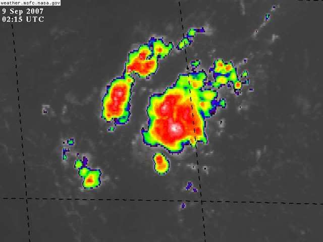
MiamiensisWx
Re: Interesting developments E of the Leewards = TWO Shortly
There's a nice burst of convective activity ahead of the wave axis. Westerly winds at H5 have been providing a hostile environment in the Caribbean Sea, but I think this system may have a chance. Additionally, the upper low near FL appears to be filling and moving slowly westward. The westerlies and trough to the north appear to be moving out of the area, too. Since Gabrielle does not appear to be getting picked up rapidly (weaker H5 trough over Ohio Valley), the low-level ridge could remain intact over this system. The wave axis should move W or WNW through the next few days, in my opinion.
http://www.ssd.noaa.gov/goes/east/tatl/loop-ir2.html
http://cimss.ssec.wisc.edu/tropic/real-time/atlantic/winds/wg8dlm1.html
The 10:30 p.m. EDT TWO didn't mention this wave, but it is an interesting area.
http://www.ssd.noaa.gov/goes/east/tatl/loop-ir2.html
http://cimss.ssec.wisc.edu/tropic/real-time/atlantic/winds/wg8dlm1.html
The 10:30 p.m. EDT TWO didn't mention this wave, but it is an interesting area.
0 likes
Who is online
Users browsing this forum: No registered users and 109 guests