ENSO Updates (2007 thru 2023)

This is the general tropical discussion area. Anyone can take their shot at predicting a storms path.

Moderator: S2k Moderators

Forum rules

The posts in this forum are NOT official forecasts and should not be used as such. They are just the opinion of the poster and may or may not be backed by sound meteorological data. They are NOT endorsed by any professional institution or STORM2K. For official information, please refer to products from the National Hurricane Center and National Weather Service.

Help Support Storm2K
Message
Author
User avatar
Kingarabian
S2K Supporter
S2K Supporter
Posts: 16027
Joined: Sat Aug 08, 2009 3:06 am
Location: Honolulu, Hawaii

Re: ENSO Updates

#8081 Postby Kingarabian » Sat Jun 03, 2017 12:51 pm

LarryWx wrote:
Kingarabian wrote:
LarryWx wrote:The latest guidance suggests most of the next 10+ days of -SOI thanks to a mostly higher than avg Darwin SLP. Though it will drop back some the next 1-2 days, guidance suggests it will then rise back and even go higher by 1-1.5 mb during 6/7-11 vs where it has been the last few days. However, most of the next 10 days will supposedly have higher Tahiti SLP's vs today's. So, these 2 will largely cancel each other. But we're starting from a solidly -SOI.

My guess: SOI rises back toward 0 the next couple of days (it may go barely +SOI for a day or so) before going back to -SOI through ~6/11. Then maybe a rise just after.


Even if Tahiti has slightly higher pressures over Darwin's, it usually counts for a drop. I'm thinking it'll simply tank hard for the next week and then level off. Followed by another drop in the long range. All in all, it looks like we wont see easterlies for the most of June.


Despite the mainly -SOI over the next 10+ days, I see almost no way that the SOI won't rise back some tomorrow and maybe also the next day before it falls back.

The high Darwin SLP's being forecasted for 6/7-11 (1014+) are what are typically seen on many June+ days in a developing Niño. So, that will be well worth monitoring. I'd call
Tahiti averaging neutral rather than pro-Niño low over the next 10 days.
If this combo of high Darwin SLP & neutral Tahiti SLP were to be the theme over the next few months, I'd think it would favor a weakish Niño forming.


Interesting. Well there's going to have to be some quick turnarounds in pressure readings then.

I currently have averaged todays pressures at:

1013.88mb - Darwin
1012.19 - Tahiti

Which would be a significant daily negative if the averages hold out the rest of the day. So I think for there to be a positive tomorrow, Tahiti's average for today has to really ramp up soon.
1 likes   
RIP Kobe Bryant

LarryWx
S2K Supporter
S2K Supporter
Posts: 6386
Joined: Sun Sep 07, 2003 2:04 pm
Location: GA

Re: ENSO Updates

#8082 Postby LarryWx » Sat Jun 03, 2017 1:23 pm

Kingarabian wrote:
LarryWx wrote:
Kingarabian wrote:

Even if Tahiti has slightly higher pressures over Darwin's, it usually counts for a drop. I'm thinking it'll simply tank hard for the next week and then level off. Followed by another drop in the long range. All in all, it looks like we wont see easterlies for the most of June.


Despite the mainly -SOI over the next 10+ days, I see almost no way that the SOI won't rise back some tomorrow and maybe also the next day before it falls back.

The high Darwin SLP's being forecasted for 6/7-11 (1014+) are what are typically seen on many June+ days in a developing Niño. So, that will be well worth monitoring. I'd call
Tahiti averaging neutral rather than pro-Niño low over the next 10 days.
If this combo of high Darwin SLP & neutral Tahiti SLP were to be the theme over the next few months, I'd think it would favor a weakish Niño forming.


Interesting. Well there's going to have to be some quick turnarounds in pressure readings then.

I currently have averaged todays pressures at:

1013.88mb - Darwin
1012.19 - Tahiti

Which would be a significant daily negative if the averages hold out the rest of the day. So I think for there to be a positive tomorrow, Tahiti's average for today has to really ramp up soon.


Then I may end up wrong but as you said we need to see the rest of the day. By the way, my old link to hourly SLP is dead. Do you have a link? TIA.
0 likes   
Personal Forecast Disclaimer:
The posts in this forum are NOT official forecasts and should not be used as such. They are just the opinion of the poster and may or may not be backed by sound meteorological data. They are NOT endorsed by any professional institution or storm2k.org. For official information, please refer to the NHC and NWS products.

User avatar
Kingarabian
S2K Supporter
S2K Supporter
Posts: 16027
Joined: Sat Aug 08, 2009 3:06 am
Location: Honolulu, Hawaii

Re: ENSO Updates

#8083 Postby Kingarabian » Sat Jun 03, 2017 1:40 pm

LarryWx wrote:
Kingarabian wrote:
LarryWx wrote:
Despite the mainly -SOI over the next 10+ days, I see almost no way that the SOI won't rise back some tomorrow and maybe also the next day before it falls back.

The high Darwin SLP's being forecasted for 6/7-11 (1014+) are what are typically seen on many June+ days in a developing Niño. So, that will be well worth monitoring. I'd call
Tahiti averaging neutral rather than pro-Niño low over the next 10 days.
If this combo of high Darwin SLP & neutral Tahiti SLP were to be the theme over the next few months, I'd think it would favor a weakish Niño forming.


Interesting. Well there's going to have to be some quick turnarounds in pressure readings then.

I currently have averaged todays pressures at:

1013.88mb - Darwin
1012.19 - Tahiti

Which would be a significant daily negative if the averages hold out the rest of the day. So I think for there to be a positive tomorrow, Tahiti's average for today has to really ramp up soon.


Then I may end up wrong but as you said we need to see the rest of the day. By the way, my old link to hourly SLP is dead. Do you have a link? TIA.


Darwin or Tahiti?
0 likes   
RIP Kobe Bryant

User avatar
Ntxw
Storm2k Moderator
Storm2k Moderator
Posts: 22792
Joined: Wed Oct 21, 2009 6:34 pm
Location: DFW, Texas

Re: ENSO Updates

#8084 Postby Ntxw » Sat Jun 03, 2017 1:45 pm

NCDC monthly PDO index updated for May at +0.36. Eyeballing it from previous readings that should fall between +0.80 and +1.1 on the Jisao (comes out second week or so) which is less than the April reading but continues the streak of unbroken positives.
0 likes   
The above post and any post by Ntxw is NOT an official forecast and should not be used as such. It is just the opinion of the poster and may or may not be backed by sound meteorological data. It is NOT endorsed by any professional institution including Storm2k. For official information, please refer to NWS products.

  Help support Storm2K!
Help Support Storm2K

LarryWx
S2K Supporter
S2K Supporter
Posts: 6386
Joined: Sun Sep 07, 2003 2:04 pm
Location: GA

Re: ENSO Updates

#8085 Postby LarryWx » Sat Jun 03, 2017 2:22 pm

Kingarabian wrote:
LarryWx wrote:
Kingarabian wrote:
Interesting. Well there's going to have to be some quick turnarounds in pressure readings then.

I currently have averaged todays pressures at:

1013.88mb - Darwin
1012.19 - Tahiti

Which would be a significant daily negative if the averages hold out the rest of the day. So I think for there to be a positive tomorrow, Tahiti's average for today has to really ramp up soon.


Then I may end up wrong but as you said we need to see the rest of the day. By the way, my old link to hourly SLP is dead. Do you have a link? TIA.


Darwin or Tahiti?


Both. By the way, I decided to take a closer look at the latest guidance and it is close to what you said for tomorrow with no more than a slight rise, if any. However, it also shows a rise to near -10 on 6/5-6. But even that says it won't approach or go barely above 0 like I thought it might for 1-2 days. So, a pretty lengthy (say 10+ days total) unbroken -SOI streak looks likely. The Darwin SLP appears likw it will max out ~1015 ~one week from today. That's pretty high vs climo. Anything above 1014 mb is safely higher than avg there I believe for June.
1 likes   
Personal Forecast Disclaimer:
The posts in this forum are NOT official forecasts and should not be used as such. They are just the opinion of the poster and may or may not be backed by sound meteorological data. They are NOT endorsed by any professional institution or storm2k.org. For official information, please refer to the NHC and NWS products.

User avatar
Kingarabian
S2K Supporter
S2K Supporter
Posts: 16027
Joined: Sat Aug 08, 2009 3:06 am
Location: Honolulu, Hawaii

Re: ENSO Updates

#8086 Postby Kingarabian » Sat Jun 03, 2017 2:52 pm

LarryWx wrote:
Kingarabian wrote:
LarryWx wrote:
Then I may end up wrong but as you said we need to see the rest of the day. By the way, my old link to hourly SLP is dead. Do you have a link? TIA.


Darwin or Tahiti?


Both. By the way, I decided to take a closer look at the latest guidance and it is close to what you said for tomorrow with no more than a slight rise, if any. However, it also shows a rise to near -10 on 6/5-6. But even that says it won't approach or go barely above 0 like I thought it might for 1-2 days. So, a pretty lengthy (say 10+ days total) unbroken -SOI streak looks likely. The Darwin SLP appears likw it will max out ~1015 ~one week from today. That's pretty high vs climo. Anything above 1014 mb is safely higher than avg there I believe for June.


Darwin: http://www.bom.gov.au/products/IDD60801 ... 4120.shtml

Tahiti: https://www.wunderground.com/history/ai ... .wmo=91938
1 likes   
RIP Kobe Bryant

User avatar
NDG
S2K Supporter
S2K Supporter
Posts: 15449
Joined: Sun Jul 09, 2006 10:14 pm
Location: Orlando, FL

Re: ENSO Updates

#8087 Postby NDG » Sat Jun 03, 2017 5:32 pm

Ntxw wrote:NCDC monthly PDO index updated for May at +0.36. Eyeballing it from previous readings that should fall between +0.80 and +1.1 on the Jisao (comes out second week or so) which is less than the April reading but continues the streak of unbroken positives.


So a trend starting back down to a more neutral stage, IMO, like it did last year which by this time was at a whopping +2.35.
Had the PDO been so positive this year as it was last year the El Nino would have not had any trouble in popping in solidly by now, IMO.
2 likes   

LarryWx
S2K Supporter
S2K Supporter
Posts: 6386
Joined: Sun Sep 07, 2003 2:04 pm
Location: GA

Re: ENSO Updates

#8088 Postby LarryWx » Sat Jun 03, 2017 5:34 pm

Kingarabian wrote:
LarryWx wrote:
Kingarabian wrote:
Darwin or Tahiti?


Both. By the way, I decided to take a closer look at the latest guidance and it is close to what you said for tomorrow with no more than a slight rise, if any. However, it also shows a rise to near -10 on 6/5-6. But even that says it won't approach or go barely above 0 like I thought it might for 1-2 days. So, a pretty lengthy (say 10+ days total) unbroken -SOI streak looks likely. The Darwin SLP appears likw it will max out ~1015 ~one week from today. That's pretty high vs climo. Anything above 1014 mb is safely higher than avg there I believe for June.


Darwin: http://www.bom.gov.au/products/IDD60801 ... 4120.shtml

Tahiti: https://www.wunderground.com/history/ai ... .wmo=91938


Thanks!

I just did some calcs based on 1981-2016 that you may find interesting:

Avg June/July/Aug Darwin SLP minus 1000: 13.0/13.5/13.5
Avg June/July/Aug Tahiti SLP minus 1000: 13.7/14.3/14.6

Avg June/July/Aug Darwin SLP minus 1000 strong Nino: 13.5/14.4/14.6
Avg June/July/Aug Darwin SLP minus 1000 wk-mod Nino: 13.0/13.8/13.7
Avg June/July/Aug Darwin SLP minus 1000 weak Nina: 13.0/13.0/12.8
Avg June/July/Aug Darwin SLP minus 1000 mod-str Nina: 12.8/13.1/12.9

Avg June/July/Aug Tahiti SLP minus 1000 strong Nino: 12.8/13.4/13.6
Avg June/July/Aug Tahiti SLP minus 1000 wk-mod Nino: 13.5/13.9/13.7
Avg June/July/Aug Tahiti SLP minus 1000 weak Nina: 14.2/14.3/15.1
Avg June/July/Aug Tahiti SLP minus 1000 mod-str Nina: 14.1/15.2/15.2

s
Some analysis of these #'s:

- At Darwin, SLP differences from one ENSO cat. to another are greater in July than June and even greater in Aug. Perhaps this means that in Nino's that avg. Australian sfc highs are stronger and/or extend further north in July/Aug vs June whereas in Nina's they stay about the same through that period?

- At Tahiti, SLP differences from one ENSO cat. to another are much greater in June than the rather narrow range for Darwin. So, perhaps this means that Tahiti is more crucial than Darwin in June. These diffs from one ENSO cat to another rise more in July from June.

- SLP averages higher in Darwin than Tahiti in strong Ninos, they average ~same in weak to mod Ninos, and are clearly higher at Tahiti than Darwin in Ninas. ALL years combined incl neutral ENSO average nearly 1 mb higher at Tahiti than Darwin. This is probably near where neutral years, alone, fall. That is why the SOI is near 0 when Tahiti is ~1 mb higher than Darwin.

- When I refer to ENSO cat., I mean the upcoming fall/winter peak as opposed to where it is during JJA.
***EDITED***
1 likes   
Personal Forecast Disclaimer:
The posts in this forum are NOT official forecasts and should not be used as such. They are just the opinion of the poster and may or may not be backed by sound meteorological data. They are NOT endorsed by any professional institution or storm2k.org. For official information, please refer to the NHC and NWS products.

User avatar
Kingarabian
S2K Supporter
S2K Supporter
Posts: 16027
Joined: Sat Aug 08, 2009 3:06 am
Location: Honolulu, Hawaii

Re: ENSO Updates

#8089 Postby Kingarabian » Sat Jun 03, 2017 5:59 pm

NDG wrote:
Ntxw wrote:NCDC monthly PDO index updated for May at +0.36. Eyeballing it from previous readings that should fall between +0.80 and +1.1 on the Jisao (comes out second week or so) which is less than the April reading but continues the streak of unbroken positives.


So a trend starting back down to a more neutral stage, IMO, like it did last year which by this time was at a whopping +2.35.
Had the PDO been so positive this year as it was last year the El Nino would have not had any trouble in popping in solidly by now, IMO.


I believe it pretty much continues the trend of a warm PDO, and its played a large role in shutting down a La Nina and promoting El Nino, despite it being rare to have successive Ninos so soon.
0 likes   
RIP Kobe Bryant

User avatar
Kingarabian
S2K Supporter
S2K Supporter
Posts: 16027
Joined: Sat Aug 08, 2009 3:06 am
Location: Honolulu, Hawaii

Re: ENSO Updates

#8090 Postby Kingarabian » Sat Jun 03, 2017 6:09 pm

LarryWx wrote:
Kingarabian wrote:
LarryWx wrote:
Both. By the way, I decided to take a closer look at the latest guidance and it is close to what you said for tomorrow with no more than a slight rise, if any. However, it also shows a rise to near -10 on 6/5-6. But even that says it won't approach or go barely above 0 like I thought it might for 1-2 days. So, a pretty lengthy (say 10+ days total) unbroken -SOI streak looks likely. The Darwin SLP appears likw it will max out ~1015 ~one week from today. That's pretty high vs climo. Anything above 1014 mb is safely higher than avg there I believe for June.


Darwin: http://www.bom.gov.au/products/IDD60801 ... 4120.shtml

Tahiti: https://www.wunderground.com/history/ai ... .wmo=91938


- SLP averages higher in Darwin than Tahiti in strong Ninos, they average ~same in weak to mod Ninos, and are clearly higher at Tahiti than Darwin in Ninas. ALL years combined incl neutral ENSO average nearly 1 mb higher at Tahiti than Darwin. This is probably near where neutral years, alone, fall. That is why the SOI is near 0 when Tahiti is ~1 mb higher than Darwin.

- When I refer to ENSO cat., I mean the upcoming fall/winter peak as opposed to where it is during JJA.
***EDITED***


Great analysis!
0 likes   
RIP Kobe Bryant

User avatar
NDG
S2K Supporter
S2K Supporter
Posts: 15449
Joined: Sun Jul 09, 2006 10:14 pm
Location: Orlando, FL

Re: ENSO Updates

#8091 Postby NDG » Sat Jun 03, 2017 7:23 pm

Kingarabian wrote:
NDG wrote:
Ntxw wrote:NCDC monthly PDO index updated for May at +0.36. Eyeballing it from previous readings that should fall between +0.80 and +1.1 on the Jisao (comes out second week or so) which is less than the April reading but continues the streak of unbroken positives.


So a trend starting back down to a more neutral stage, IMO, like it did last year which by this time was at a whopping +2.35.
Had the PDO been so positive this year as it was last year the El Nino would have not had any trouble in popping in solidly by now, IMO.


I believe it pretty much continues the trend of a warm PDO, and its played a large role in shutting down a La Nina and promoting El Nino, despite it being rare to have successive Ninos so soon.


I am calling for it to go negative briefly this summer, by the trends that I am looking at.
1 likes   

User avatar
Ntxw
Storm2k Moderator
Storm2k Moderator
Posts: 22792
Joined: Wed Oct 21, 2009 6:34 pm
Location: DFW, Texas

Re: ENSO Updates

#8092 Postby Ntxw » Sat Jun 03, 2017 7:33 pm

Kingarabian wrote:
NDG wrote:
Ntxw wrote:NCDC monthly PDO index updated for May at +0.36. Eyeballing it from previous readings that should fall between +0.80 and +1.1 on the Jisao (comes out second week or so) which is less than the April reading but continues the streak of unbroken positives.


So a trend starting back down to a more neutral stage, IMO, like it did last year which by this time was at a whopping +2.35.
Had the PDO been so positive this year as it was last year the El Nino would have not had any trouble in popping in solidly by now, IMO.


I believe it pretty much continues the trend of a warm PDO, and its played a large role in shutting down a La Nina and promoting El Nino, despite it being rare to have successive Ninos so soon.


The 3 other monster El Nino's were followed by double Ninas or cold neutral/Nina combo. Most major Nino events are except 1957 which warm events followed. In theory this year should have been another Nina. I've heard calls of it going negative last year and didn't with a NIna. Unless I see something change the +PDO is running 40+ months straight, the longest of it's warm phase since 1900
0 likes   
The above post and any post by Ntxw is NOT an official forecast and should not be used as such. It is just the opinion of the poster and may or may not be backed by sound meteorological data. It is NOT endorsed by any professional institution including Storm2k. For official information, please refer to NWS products.


  Help support Storm2K!

Help Support Storm2K


User avatar
Kingarabian
S2K Supporter
S2K Supporter
Posts: 16027
Joined: Sat Aug 08, 2009 3:06 am
Location: Honolulu, Hawaii

Re: ENSO Updates

#8093 Postby Kingarabian » Sat Jun 03, 2017 8:00 pm

NDG wrote:
Kingarabian wrote:
NDG wrote:
So a trend starting back down to a more neutral stage, IMO, like it did last year which by this time was at a whopping +2.35.
Had the PDO been so positive this year as it was last year the El Nino would have not had any trouble in popping in solidly by now, IMO.


I believe it pretty much continues the trend of a warm PDO, and its played a large role in shutting down a La Nina and promoting El Nino, despite it being rare to have successive Ninos so soon.


I am calling for it to go negative briefly this summer, by the trends that I am looking at.


Based on the NESDIS Anomalies?
0 likes   
RIP Kobe Bryant

User avatar
NDG
S2K Supporter
S2K Supporter
Posts: 15449
Joined: Sun Jul 09, 2006 10:14 pm
Location: Orlando, FL

Re: ENSO Updates

#8094 Postby NDG » Sat Jun 03, 2017 8:53 pm

Kingarabian wrote:
NDG wrote:
Kingarabian wrote:
I believe it pretty much continues the trend of a warm PDO, and its played a large role in shutting down a La Nina and promoting El Nino, despite it being rare to have successive Ninos so soon.


I am calling for it to go negative briefly this summer, by the trends that I am looking at.


Based on the NESDIS Anomalies?


If this trend continues.

Image
2 likes   

User avatar
weathaguyry
Category 5
Category 5
Posts: 1272
Age: 22
Joined: Wed Jun 15, 2016 5:16 am
Location: Long Island, NY

Re: ENSO Updates

#8095 Postby weathaguyry » Sat Jun 03, 2017 9:34 pm

NDG wrote:
Kingarabian wrote:
NDG wrote:
I am calling for it to go negative briefly this summer, by the trends that I am looking at.


Based on the NESDIS Anomalies?


If this trend continues.

Image


I agree, with that stream of cold anomalies running down the west coast, it does not at all resemble a very +PDO, now there is average water temps in the areas that are usually warm in a very +PDO. We are starting off this year with the PDO less than it was last year, and also just by glancing at the SST anomalies, I would say PDO is about .50 right now, but I understand that there is a lot more that goes into calculating the values, but overall, I would expect a slight drop for May from the JISAO maybe +.8-+.95
0 likes   
My posts are only my opinions and NOT official forecasts. For official forecasts, consult the National Hurricane Center or the National Weather Service.

Irene 11', Sandy 12', Fay 20’, Isaias 20’, Elsa 21’, Henri 21’, Ida 21’

User avatar
Ntxw
Storm2k Moderator
Storm2k Moderator
Posts: 22792
Joined: Wed Oct 21, 2009 6:34 pm
Location: DFW, Texas

Re: ENSO Updates

#8096 Postby Ntxw » Sat Jun 03, 2017 9:48 pm

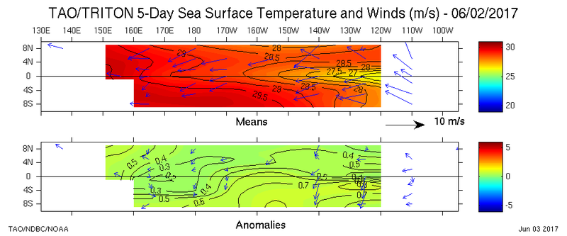
Buoys week to week suggest Monday will be +/- 0.5C again

Image
0 likes   
The above post and any post by Ntxw is NOT an official forecast and should not be used as such. It is just the opinion of the poster and may or may not be backed by sound meteorological data. It is NOT endorsed by any professional institution including Storm2k. For official information, please refer to NWS products.


  Help support Storm2K!

Help Support Storm2K


User avatar
Ntxw
Storm2k Moderator
Storm2k Moderator
Posts: 22792
Joined: Wed Oct 21, 2009 6:34 pm
Location: DFW, Texas

Re: ENSO Updates

#8097 Postby Ntxw » Sat Jun 03, 2017 9:50 pm

weathaguyry wrote:I agree, with that stream of cold anomalies running down the west coast, it does not at all resemble a very +PDO, now there is average water temps in the areas that are usually warm in a very +PDO. We are starting off this year with the PDO less than it was last year, and also just by glancing at the SST anomalies, I would say PDO is about .50 right now, but I understand that there is a lot more that goes into calculating the values, but overall, I would expect a slight drop for May from the JISAO maybe +.8-+.95


The PDO Mantua box is more than just the west coast of North America, that is only a small portion. It stretches from Japan to the below the Aleutian Islands towards Hawaii as well. A true -PDO is warm in those areas along with a cold west coast.

2012 is a good example of a cold PDO aborted Nino attempt. This is the kind of configuration to look for if it were to flip

Image
0 likes   
The above post and any post by Ntxw is NOT an official forecast and should not be used as such. It is just the opinion of the poster and may or may not be backed by sound meteorological data. It is NOT endorsed by any professional institution including Storm2k. For official information, please refer to NWS products.


  Help support Storm2K!

Help Support Storm2K


User avatar
NDG
S2K Supporter
S2K Supporter
Posts: 15449
Joined: Sun Jul 09, 2006 10:14 pm
Location: Orlando, FL

Re: ENSO Updates

#8098 Postby NDG » Sat Jun 03, 2017 10:18 pm

Ntxw wrote:Buoys week to week suggest Monday will be +/- 0.5C again

http://3.1m.yt/a3KUNBQ.jpg


Here's a more detailed image.


Image
1 likes   

LarryWx
S2K Supporter
S2K Supporter
Posts: 6386
Joined: Sun Sep 07, 2003 2:04 pm
Location: GA

Re: ENSO Updates

#8099 Postby LarryWx » Sat Jun 03, 2017 10:32 pm

Kingarabian wrote:
LarryWx wrote:


- SLP averages higher in Darwin than Tahiti in strong Ninos, they average ~same in weak to mod Ninos, and are clearly higher at Tahiti than Darwin in Ninas. ALL years combined incl neutral ENSO average nearly 1 mb higher at Tahiti than Darwin. This is probably near where neutral years, alone, fall. That is why the SOI is near 0 when Tahiti is ~1 mb higher than Darwin.

- When I refer to ENSO cat., I mean the upcoming fall/winter peak as opposed to where it is during JJA.
***EDITED***


Great analysis!


Thanks, King! Actually, I had not intended to do this but after mentioning that I thought 1014 mb was above the June normal SLP at Darwin, I got curious. I'm glad I did because I learned some new things and will have these #'s to compare to as we go through the summer to give a better idea about how things are looking for the upcoming fall/winter ENSO. Here are my sources:

Darwin monthly SLP (I started with 1981): http://www.cpc.ncep.noaa.gov/data/indices/darwin

Tahiti monthly SLP (I started with 1981):
http://www.cpc.ncep.noaa.gov/data/indices/tahiti
2 likes   
Personal Forecast Disclaimer:
The posts in this forum are NOT official forecasts and should not be used as such. They are just the opinion of the poster and may or may not be backed by sound meteorological data. They are NOT endorsed by any professional institution or storm2k.org. For official information, please refer to the NHC and NWS products.

LarryWx
S2K Supporter
S2K Supporter
Posts: 6386
Joined: Sun Sep 07, 2003 2:04 pm
Location: GA

Re: ENSO Updates

#8100 Postby LarryWx » Sat Jun 03, 2017 11:05 pm

Ntxw wrote:
Kingarabian wrote:
NDG wrote:
So a trend starting back down to a more neutral stage, IMO, like it did last year which by this time was at a whopping +2.35.
Had the PDO been so positive this year as it was last year the El Nino would have not had any trouble in popping in solidly by now, IMO.


I believe it pretty much continues the trend of a warm PDO, and its played a large role in shutting down a La Nina and promoting El Nino, despite it being rare to have successive Ninos so soon.


The 3 other monster El Nino's were followed by double Ninas or cold neutral/Nina combo. Most major Nino events are except 1957 which warm events followed. In theory this year should have been another Nina. I've heard calls of it going negative last year and didn't with a NIna. Unless I see something change the +PDO is running 40+ months straight, the longest of it's warm phase since 1900


Actually, I can extend this further and say that the six strongest Nino's previous to 2015-6 since the late 1800's were all followed by a double cold ENSO. However, in all six of these cases, the 2nd spring was also cold ENSO. The spring of 2017 has been different with its
warm neutral. So, that may be a sign that the double cold ENSO won't occur this time and may allow for a warm ENSO in 2017-8. Also, six is still not a big sample size. We'll see what happens.
3 likes   
Personal Forecast Disclaimer:
The posts in this forum are NOT official forecasts and should not be used as such. They are just the opinion of the poster and may or may not be backed by sound meteorological data. They are NOT endorsed by any professional institution or storm2k.org. For official information, please refer to the NHC and NWS products.


Return to “Talkin' Tropics”

Who is online

Users browsing this forum: cainjamin and 61 guests