


Seasonal OLR depicts pretty well the Indonesian convection (also favors Africa) for the past few months

Moderator: S2k Moderators


Ntxw wrote:It's becoming more evident, for July, that the background state will move to look more like an El Nino episode. CFSv2 showed this as others posted, OP guidance is moving that way. Tropical forcing will center near the dateline and progress eastward. For the past few months it has been focused over Indonesia which is more favored for La Nina.
tarheelprogrammer wrote:A negative for the Atlantic correct?
Ntxw wrote:It's becoming more evident, for July, that the background state will move to look more like an El Nino episode. CFSv2 showed this as others posted, OP guidance is moving that way. Tropical forcing will center near the dateline and progress eastward. For the past few months it has been focused over Indonesia which is more favored for La Nina.
Seasonal OLR depicts pretty well the Indonesian convection (also favors Africa) for the past few months
Ntxw wrote:tarheelprogrammer wrote:A negative for the Atlantic correct?
If the forecasts are correct, there could be more episodes of mid level dry air with that kind of spatial pattern. CPAC and WPAC activity would likely pick up.
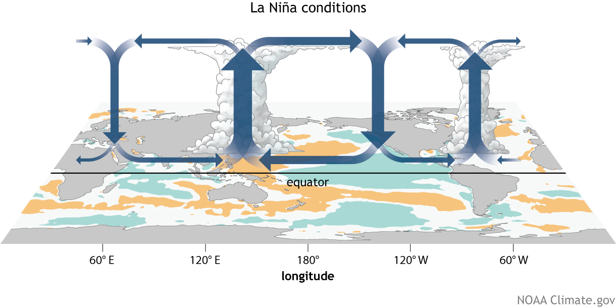
TheStormExpert wrote:Wouldn't that green area eventually migrate east into the Atlantic basin as time progresses? I don't quite understand the map.
RL3AO wrote:Ntxw wrote:tarheelprogrammer wrote:A negative for the Atlantic correct?
If the forecasts are correct, there could be more episodes of mid level dry air with that kind of spatial pattern. CPAC and WPAC activity would likely pick up.
I will note some unpublished research I've seen that shows the CFS under forecasts convection over the Maritime Continent during NH summer and over forecasts convection in the central/east Pacific.
Ntxw wrote:TheStormExpert wrote:Wouldn't that green area eventually migrate east into the Atlantic basin as time progresses? I don't quite understand the map.
It is a much broader, overall background state and it tends to traverse the tropics from the Indian Ocean through the Pacific. It doesn't really go to the Atlantic as the walker cell is often ENSO driven. The favorable area for the Atlantic is when convection persists over Indonesia and the Maritime continent. That spatial pattern reflects a more Nina-like background state and can help boost African convection and the MDR with rising air as we have seen the past 12+ months. But that pattern will be changing.

Kingarabian wrote:Here are my averages for today and the next 3 days:Code: Select all
June 29: Tahiti: 1013.75,   Darwin: 1013.50, Daily value: -6 to -8
June 30: Tahiti: 1013.25,   Darwin: 1013.75, Daily value: -10 to -12
July 01:  Tahiti:  1012.00,  Darwin: 1013.00, Daily value:  -15
July 02:  Tahiti:  1013.00,  Darwin: 1013.75, Daily value:  -13
My daily values may be slightly off since I'm just eyeballing longpaddock's previous estimates and applying them here.
Now looking ahead past this weekend, Tuesday to Thursday look really positive according to the GFS. Could see +10's to +25's. Then by next week Friday and through the weekend it'll flip negative again, and we could also see -10's to -25's. GFS is showing long spells of 1016's sitting over Darwin late next week. However this is a long way out, and models show little skill this far out.
Edit: In the beginning of June, I recall the EPS weeklies showing a week in July with positive daily values before they tanked again. Looks like it'll be this upcoming week.
TheStormExpert wrote:What will this all mean for the remainder of the Atlantic hurricane season ?
TheStormExpert wrote:Also what exactly is the Walker Cell?
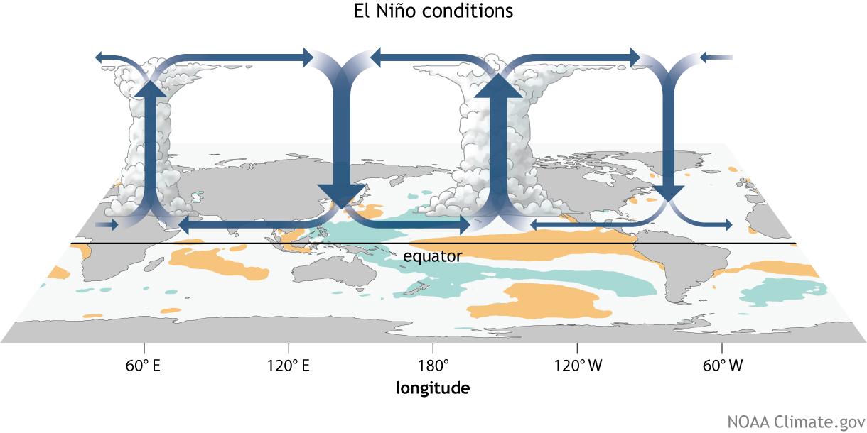
TheStormExpert wrote:Also what exactly is the Walker Cell?


Kingarabian wrote:However in a Modoki event, Nino 1+2 is substantially cooler than what it is now. Nino 1+2 is actually quite warm at the current moment, but check the GOM where we see cool anomalies. Could it be that the sinking air is landing in the GOM vs the eastern EPAC?
cycloneye wrote:Kingarabian wrote:However in a Modoki event, Nino 1+2 is substantially cooler than what it is now. Nino 1+2 is actually quite warm at the current moment, but check the GOM where we see cool anomalies. Could it be that the sinking air is landing in the GOM vs the eastern EPAC?
[img]http://i.imgur.com/obwSAOI.gif[/mg]
Part of that cooling is related to Cindy.

TheStormExpert wrote::uarrow: SST's in the GoM are already in the mid-upper 80's so I don't know what all the fuss about slightly cooler than average anomalies is.
Kingarabian wrote:TheStormExpert wrote::uarrow: SST's in the GoM are already in the mid-upper 80's so I don't know what all the fuss about slightly cooler than average anomalies is.
The GOM SST's are almost always sufficient enough to support the strongest of hurricanes. However, what the above map is showing is that the GOM this year is anomalously cooler than the 30 year average. So something IS going on there.
Kingarabian wrote:However in a Modoki event, Nino 1+2 is substantially cooler than what it is now. Nino 1+2 is actually quite warm at the current moment, but check the GOM where we see cool anomalies. Could it be that the sinking air is landing in the GOM vs the eastern EPAC?
Users browsing this forum: No registered users and 93 guests
