I will say this though. Should this system goes on to organize into a significant tropical entity, this thread will implode as well
NW Carribean / Southern GOM / BOC (Is invest 96L)
Moderator: S2k Moderators
Forum rules

The posts in this forum are NOT official forecasts and should not be used as such. They are just the opinion of the poster and may or may not be backed by sound meteorological data. They are NOT endorsed by any professional institution or STORM2K. For official information, please refer to products from the National Hurricane Center and National Weather Service.
-
northjaxpro

- S2K Supporter

- Posts: 8900
- Joined: Mon Sep 27, 2010 11:21 am
- Location: Jacksonville, FL
cycloneye, you beat me to that mention lol. I can't ever recall seeing so many posts on a thread on Storm2K with a system which has not even been declared as an invest yet.
I will say this though. Should this system goes on to organize into a significant tropical entity, this thread will implode as well
I will say this though. Should this system goes on to organize into a significant tropical entity, this thread will implode as well
0 likes
NEVER, EVER SAY NEVER in the tropics and weather in general, and most importantly, with life itself!!
________________________________________________________________________________________
Fay 2008 Beryl 2012 Debby 2012 Colin 2016 Hermine 2016 Julia 2016 Matthew 2016 Irma 2017 Dorian 2019
________________________________________________________________________________________
Fay 2008 Beryl 2012 Debby 2012 Colin 2016 Hermine 2016 Julia 2016 Matthew 2016 Irma 2017 Dorian 2019
-
Aric Dunn
- Category 5

- Posts: 21238
- Age: 43
- Joined: Sun Sep 19, 2004 9:58 pm
- Location: Ready for the Chase.
- Contact:
Re: NW Carribean / Southern GOM / BOC
tolakram wrote:Waiting patiently for the first visible to see how the swirl is doing.If it's still there I predict an invest in the next couple of hours.
Very hard to see anything in this loop: http://rammb.cira.colostate.edu/ramsdis ... _floater_1
The posts in this forum are NOT official forecast and should not be used as such. They are just the opinion of the poster and may or may not be backed by sound meteorological data. They are NOT endorsed by any professional institution or storm2k.org. For official information, please refer to the NHC and NWS products.
if u use the rgb u can track it all night its still there now north of the yucatan. the is not so much there anymore
0 likes
Note: If I make a post that is brief. Please refer back to previous posts for the analysis or reasoning. I do not re-write/qoute what my initial post said each time.
If there is nothing before... then just ask
Space & Atmospheric Physicist, Embry-Riddle Aeronautical University,
I believe the sky is falling...
If there is nothing before... then just ask
Space & Atmospheric Physicist, Embry-Riddle Aeronautical University,
I believe the sky is falling...
-
cycloneye

- Admin

- Posts: 149276
- Age: 69
- Joined: Thu Oct 10, 2002 10:54 am
- Location: San Juan, Puerto Rico
Re:
northjaxpro wrote:cycloneye, you beat me to that mention lol. I can't ever recall seeing so many posts on a thread on Storm2K with a system which has not even been declared as an invest yet.
I will say this though. Should this system goes on to organize into a significant tropical entity,
Well,not this one. The 96L thread will explode if what you describe occurs and may try to beat the Ivan's thread that had over 600 pages.
0 likes
Visit the Caribbean-Central America Weather Thread where you can find at first post web cams,radars
and observations from Caribbean basin members Click Here
and observations from Caribbean basin members Click Here
-
cycloneye
- Admin
- Posts: 149276
- Age: 69
- Joined: Thu Oct 10, 2002 10:54 am
- Location: San Juan, Puerto Rico
Re: NW Carribean / Southern GOM / BOC
TROPICAL WEATHER OUTLOOK
NWS NATIONAL HURRICANE CENTER MIAMI FL
800 AM EDT THU JUN 21 2012
FOR THE NORTH ATLANTIC...CARIBBEAN SEA AND THE GULF OF MEXICO...
THE NATIONAL HURRICANE CENTER IS ISSUING ADVISORIES ON TROPICAL
STORM CHRIS...LOCATED ABOUT 630 MILES SOUTHEAST OF CAPE RACE
NEWFOUNDLAND.
A BROAD AREA OF LOW PRESSURE OVER THE SOUTH-CENTRAL GULF OF MEXICO
IS PRODUCING A LARGE AREA OF CLOUDINESS... SHOWERS...AND
THUNDERSTORMS THAT EXTENDS FROM THE NORTHWESTERN CARIBBEAN SEA
NORTHWARD INTO THE SOUTHEASTERN GULF OF MEXICO AND FLORIDA.
STRONG UPPER-LEVEL WINDS OVER THE GULF OF MEXICO ARE EXPECTED TO
DIMINISH IN A DAY OR SO...AND SOME GRADUAL DEVELOPMENT OF THIS
SYSTEM IS POSSIBLE AS THE DISTURBANCE MOVES SLOWLY NORTHWARD TOWARD
THE CENTRAL GULF OF MEXICO. THIS SYSTEM HAS A MEDIUM CHANCE...30
PERCENT...OF BECOMING A TROPICAL CYCLONE DURING THE NEXT 48 HOURS.
REGARDLESS OF DEVELOPMENT...HEAVY RAINS AND LOCALIZED FLOODING ARE
POSSIBLE ACROSS THE YUCATAN PENINSULA...WESTERN CUBA...AND SOUTHERN
FLORIDA THROUGH SATURDAY.
ELSEWHERE...TROPICAL CYCLONE FORMATION IS NOT EXPECTED DURING THE
NEXT 48 HOURS.
$$
FORECASTER BROWN/ROBERTS
0 likes
Visit the Caribbean-Central America Weather Thread where you can find at first post web cams,radars
and observations from Caribbean basin members Click Here
and observations from Caribbean basin members Click Here
-
StormingB81

- S2K Supporter
- Posts: 5676
- Age: 44
- Joined: Thu Aug 27, 2009 1:45 am
- Location: Rockledge, Florida
-
northjaxpro
- S2K Supporter
- Posts: 8900
- Joined: Mon Sep 27, 2010 11:21 am
- Location: Jacksonville, FL
Thanks cycloneye. I meant explode, not implode LOL....
But yeah, it is about to get very crazy on Storm2K as soon as this system is tagged as an invest. Maybe today we will see this finally occur.
But yeah, it is about to get very crazy on Storm2K as soon as this system is tagged as an invest. Maybe today we will see this finally occur.
Last edited by northjaxpro on Thu Jun 21, 2012 6:47 am, edited 1 time in total.
0 likes
NEVER, EVER SAY NEVER in the tropics and weather in general, and most importantly, with life itself!!
________________________________________________________________________________________
Fay 2008 Beryl 2012 Debby 2012 Colin 2016 Hermine 2016 Julia 2016 Matthew 2016 Irma 2017 Dorian 2019
________________________________________________________________________________________
Fay 2008 Beryl 2012 Debby 2012 Colin 2016 Hermine 2016 Julia 2016 Matthew 2016 Irma 2017 Dorian 2019
-
tolakram
- Admin
- Posts: 20179
- Age: 62
- Joined: Sun Aug 27, 2006 8:23 pm
- Location: Florence, KY (name is Mark)
Re: NW Carribean / Southern GOM / BOC
The swirl lives.

0 likes
M a r k
- - - - -
Join us in chat: Storm2K Chatroom Invite. Android and IOS apps also available.
The posts in this forum are NOT official forecasts and should not be used as such. Posts are NOT endorsed by any professional institution or STORM2K.org. For official information and forecasts, please refer to NHC and NWS products.
-
cycloneye
- Admin
- Posts: 149276
- Age: 69
- Joined: Thu Oct 10, 2002 10:54 am
- Location: San Juan, Puerto Rico
Re: NW Carribean / Southern GOM / BOC
And we can emigrate to Active Storm/Invests forum very soon.
0 likes
Visit the Caribbean-Central America Weather Thread where you can find at first post web cams,radars
and observations from Caribbean basin members Click Here
and observations from Caribbean basin members Click Here


Re: NW Carribean / Southern GOM / BOC
Looking at 6Z NAM right now, shows it moving north and then, about 150 miles south of Louisiana, it starts drifting westward
http://mag.ncep.noaa.gov/NCOMAGWEB/appcontroller?prevPage=Model&MainPage=index&image=&page=Param&cycle=06%2F21%2F2012+06UTC&rname=SFC-LAYER+PARMS&pname=1000_500_thick&pdesc=&model=NAM&area=NAMER&cat=MODEL+GUIDANCE&fcast=Loop+All&areaDesc=North+America+-+US+Canada+and+northern+Mexico&prevArea=NAMER&currKey=model&returnToModel=&imageSize=M
http://mag.ncep.noaa.gov/NCOMAGWEB/appcontroller?prevPage=Model&MainPage=index&image=&page=Param&cycle=06%2F21%2F2012+06UTC&rname=SFC-LAYER+PARMS&pname=1000_500_thick&pdesc=&model=NAM&area=NAMER&cat=MODEL+GUIDANCE&fcast=Loop+All&areaDesc=North+America+-+US+Canada+and+northern+Mexico&prevArea=NAMER&currKey=model&returnToModel=&imageSize=M
0 likes
-
tolakram
- Admin
- Posts: 20179
- Age: 62
- Joined: Sun Aug 27, 2006 8:23 pm
- Location: Florence, KY (name is Mark)
Re: NW Carribean / Southern GOM / BOC
live visible loop, only 3 frames so far: http://wwwghcc.msfc.nasa.gov/cgi-bin/ge ... umframes=3
0 likes
M a r k
- - - - -
Join us in chat: Storm2K Chatroom Invite. Android and IOS apps also available.
The posts in this forum are NOT official forecasts and should not be used as such. Posts are NOT endorsed by any professional institution or STORM2K.org. For official information and forecasts, please refer to NHC and NWS products.
- - - - -
Join us in chat: Storm2K Chatroom Invite. Android and IOS apps also available.
The posts in this forum are NOT official forecasts and should not be used as such. Posts are NOT endorsed by any professional institution or STORM2K.org. For official information and forecasts, please refer to NHC and NWS products.
-
cycloneye
- Admin
- Posts: 149276
- Age: 69
- Joined: Thu Oct 10, 2002 10:54 am
- Location: San Juan, Puerto Rico
Re: NW Carribean / Southern GOM / BOC
Special Feature discussion:
THE 1010 MB LOW HAS DISSIPATED LEAVING A SURFACE TROUGH AT
21/0900 UTC EXTENDING FROM 29N85W THROUGH THE YUCATAN CHANNEL TO
20N87W. STRONG UPPER-LEVEL WINDS OVER THE GULF OF MEXICO ARE
EXPECTED TO DIMINISH IN A DAY OR SO...AND SOME GRADUAL
DEVELOPMENT OF THIS SYSTEM IS POSSIBLE AS THE DISTURBANCE MOVES
SLOWLY NORTHWARD TOWARD THE CENTRAL GULF OF MEXICO. THIS SYSTEM
HAS A MEDIUM CHANCE OF BECOMING A TROPICAL CYCLONE DURING THE
NEXT 48 HOURS. REGARDLESS OF DEVELOPMENT...HEAVY RAINS AND
LOCALIZED FLOODING ARE POSSIBLE ACROSS THE YUCATAN PENINSULA...
WESTERN CUBA...AND SOUTHERN FLORIDA THROUGH SATURDAY. SCATTERED
SHOWERS/ISOLATED THUNDERSTORMS ARE OVER WITHIN 75 NM OF LINE
FROM 22N81W TO 21N87W INCLUDING PORTIONS OF CUBA...SE GULF OF
MEXICO AND NW CARIBBEAN. SCATTERED SHOWERS AND POSSIBLE ISOLATED
THUNDERSTORMS ARE OVER THE E GULF OF MEXICO S OF 29N W OF 90W...
OVER THE NW CARIBBEAN N OF 19N W OF 77W...AND PORTIONS OF THE
BAHAMAS S OF 26N W OF 75W ACROSS FLORIDA AND THROUGH THE STRAITS
OF FLORIDA AND WITHIN 120 NM N OF HISPANIOLA.
0 likes
Visit the Caribbean-Central America Weather Thread where you can find at first post web cams,radars
and observations from Caribbean basin members Click Here
and observations from Caribbean basin members Click Here
-
cycloneye
- Admin
- Posts: 149276
- Age: 69
- Joined: Thu Oct 10, 2002 10:54 am
- Location: San Juan, Puerto Rico
Re: NW Carribean / Southern GOM / BOC
8:05 AM EDT discussion of Gulf of Mexico:
GULF OF MEXICO...
AN UPPER RIDGE EXTENDS FROM AN UPPER HIGH OVER THE YUCATAN
CHANNEL NW TO THE LOUISIANA/TEXAS COAST COVERING ALL BUT THE FAR
NE GULF. DIFFLUENCE ALOFT TO THE W OF THE UPPER RIDGE IS
GENERATING SCATTERED SHOWERS/ISOLATED THUNDERSTORMS W OF 92W TO
INLAND OVER MEXICO AND TEXAS. AN UPPER LOW IS INLAND OVER S
ALABAMA EXTENDING AN UPPER TROUGH TO OVER THE FAR NE GULF. THE
ACTIVITY OVER THE E GULF IS DESCRIBED IN THE SPECIAL FEATURES
SECTION ABOVE. THE SURFACE TROUGH WILL MOVE INTO THE CENTRAL
GULF AS A NEW LOW PRESSURE IS EXPECTED TO FORM OVER YUCATAN
TODAY AND MOVE INTO THE S CENTRAL GULF THROUGH SAT POSSIBLY AS A
TROPICAL CYCLONE. THE LOW IS THEN EXPECTED TO TRACK NE TO THE E
GULF SUN AND MON.
0 likes
Visit the Caribbean-Central America Weather Thread where you can find at first post web cams,radars
and observations from Caribbean basin members Click Here
and observations from Caribbean basin members Click Here
-
Aric Dunn
- Category 5
- Posts: 21238
- Age: 43
- Joined: Sun Sep 19, 2004 9:58 pm
- Location: Ready for the Chase.
- Contact:
Re: NW Carribean / Southern GOM / BOC
The shear is dropping the anticyclone is nosing its way up into the central gulf. Things should begin to fire today.

0 likes
Note: If I make a post that is brief. Please refer back to previous posts for the analysis or reasoning. I do not re-write/qoute what my initial post said each time.
If there is nothing before... then just ask
Space & Atmospheric Physicist, Embry-Riddle Aeronautical University,
I believe the sky is falling...
If there is nothing before... then just ask
Space & Atmospheric Physicist, Embry-Riddle Aeronautical University,
I believe the sky is falling...


-
tolakram
- Admin
- Posts: 20179
- Age: 62
- Joined: Sun Aug 27, 2006 8:23 pm
- Location: Florence, KY (name is Mark)
Re: NW Carribean / Southern GOM / BOC
06Z GFS shows no real development until east of Florida, similar to 00z.
0 likes
M a r k
- - - - -
Join us in chat: Storm2K Chatroom Invite. Android and IOS apps also available.
The posts in this forum are NOT official forecasts and should not be used as such. Posts are NOT endorsed by any professional institution or STORM2K.org. For official information and forecasts, please refer to NHC and NWS products.
- - - - -
Join us in chat: Storm2K Chatroom Invite. Android and IOS apps also available.
The posts in this forum are NOT official forecasts and should not be used as such. Posts are NOT endorsed by any professional institution or STORM2K.org. For official information and forecasts, please refer to NHC and NWS products.
-
Rgv20

- S2K Supporter
- Posts: 2466
- Age: 39
- Joined: Wed Jan 05, 2011 5:42 pm
- Location: Edinburg/McAllen Tx
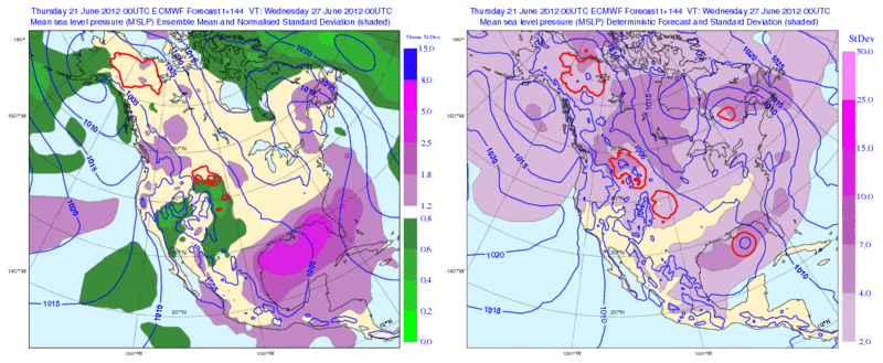
0zECMWF Ensemble Means continue to point out that the forecast can change in a hurry. The operational ECMWF run by 144hrs has this potential TC in the Eastern Gulf while you can see below the Ensemble Means want to place it in the Western/Central Gulf. It is interesting the battle that is going on between the Operational run and the Ensemble Members of both the GFS&ECMWF...lets see who wins! 
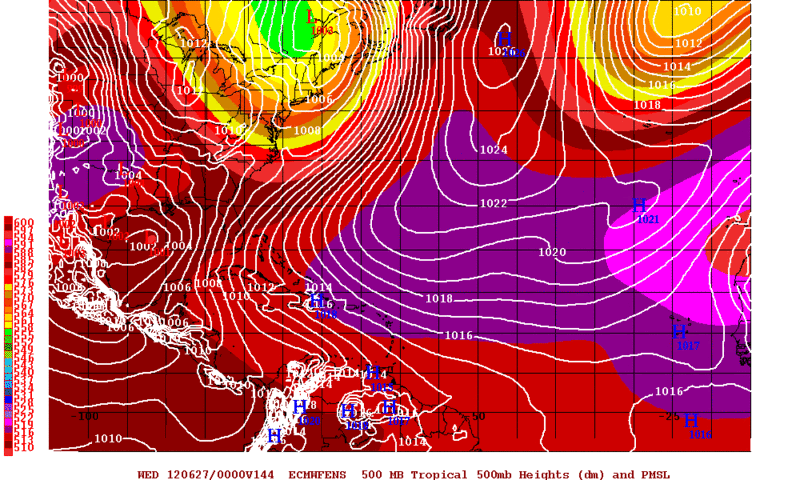
Just another graphic with the same forecast stamp as above, the purple shading just indicates how much uncertainties is going on the the Euro model.
Just another graphic with the same forecast stamp as above, the purple shading just indicates how much uncertainties is going on the the Euro model.
0 likes
The following post is NOT an official forecast and should not be used as such. It is just the opinion of the poster and may or may not be backed by sound meteorological data. It is NOT endorsed by any professional institution including storm2k.org For Official Information please refer to the NHC and NWS products.
-
cycloneye
- Admin
- Posts: 149276
- Age: 69
- Joined: Thu Oct 10, 2002 10:54 am
- Location: San Juan, Puerto Rico
Re: NW Carribean / Southern GOM / BOC
Off Topic= To let know the members that we got the first hurricane of 2012 Atlantic Season!!!!! Go to Active Storms/Invests forum to see the breaking news.
0 likes
Visit the Caribbean-Central America Weather Thread where you can find at first post web cams,radars
and observations from Caribbean basin members Click Here
and observations from Caribbean basin members Click Here
-
tolakram
- Admin
- Posts: 20179
- Age: 62
- Joined: Sun Aug 27, 2006 8:23 pm
- Location: Florence, KY (name is Mark)
Re: NW Carribean / Southern GOM / BOC
I think the swirl is dissipating. Probably the fact that the images and loops we have access too are delayed a bit.
http://wwwghcc.msfc.nasa.gov/cgi-bin/ge ... umframes=5
I agree, just north of YP is now the area to watch.
http://wwwghcc.msfc.nasa.gov/cgi-bin/ge ... umframes=5
I agree, just north of YP is now the area to watch.
0 likes
M a r k
- - - - -
Join us in chat: Storm2K Chatroom Invite. Android and IOS apps also available.
The posts in this forum are NOT official forecasts and should not be used as such. Posts are NOT endorsed by any professional institution or STORM2K.org. For official information and forecasts, please refer to NHC and NWS products.
- - - - -
Join us in chat: Storm2K Chatroom Invite. Android and IOS apps also available.
The posts in this forum are NOT official forecasts and should not be used as such. Posts are NOT endorsed by any professional institution or STORM2K.org. For official information and forecasts, please refer to NHC and NWS products.

Re: NW Carribean / Southern GOM / BOC
Not positive - but the original cloudless swirl seems to be the player - as the big blob of weather between W. Cuba and Yucatan appears to be migrating north towards that low swirl (filling in the center)
Ant cyclone is forming - as the ULL's surrounding Gulf now far enough away and beggining to ventilate the S.E. Gulf zone. This could be a formidable system in time - bringing tremendous downpours to Fl west coast
All above is just unofficial guess work
Ant cyclone is forming - as the ULL's surrounding Gulf now far enough away and beggining to ventilate the S.E. Gulf zone. This could be a formidable system in time - bringing tremendous downpours to Fl west coast
All above is just unofficial guess work
0 likes
Who is online
Users browsing this forum: Bing [Bot], Blown Away, dexterlabio, Google Adsense [Bot] and 177 guests