ENSO Updates (2007 thru 2023)

This is the general tropical discussion area. Anyone can take their shot at predicting a storms path.

Moderator: S2k Moderators

Forum rules

The posts in this forum are NOT official forecasts and should not be used as such. They are just the opinion of the poster and may or may not be backed by sound meteorological data. They are NOT endorsed by any professional institution or STORM2K. For official information, please refer to products from the National Hurricane Center and National Weather Service.

Help Support Storm2K
Message
Author
User avatar
NDG
S2K Supporter
S2K Supporter
Posts: 14942
Joined: Sun Jul 09, 2006 10:14 pm
Location: Orlando, FL

Re: ENSO: ONI for JFM up to -0.8C

#9081 Postby NDG » Wed Apr 04, 2018 10:33 pm

Kingarabian wrote:
NDG wrote:
NotSparta wrote:There are 3 analogs since 1950 with similar ENSO conditions that an El Nino form by ASO - 1976, 2006, and 2009, with the new JFM data


By this time in 2006 & 2009 Nino 3.4 was rapidly warming up into cool neutral zone and warm neutral by early May.


If you look at my previous post of the buoys, 2006, and 2009 are behind 2018 at this present time. We're approaching warm-neutral quicker than 2006 and 2009.


I was going by the CPC's weekly Nino 3.4 SSTs official readings.

29MAR2006 27.0-0.5
05APR2006 27.3-0.3
12APR2006 27.7 0.0
17MAY2006 28.1 0.2

25MAR2009 26.8-0.6
01APR2009 27.1-0.4
08APR2009 27.4-0.2
06MAY2009 27.9 0.1
3 likes   

User avatar
Kingarabian
S2K Supporter
S2K Supporter
Posts: 15461
Joined: Sat Aug 08, 2009 3:06 am
Location: Honolulu, Hawaii

Re: ENSO: ONI for JFM up to -0.8C

#9082 Postby Kingarabian » Wed Apr 04, 2018 10:41 pm

NDG wrote:
Kingarabian wrote:
NDG wrote:
By this time in 2006 & 2009 Nino 3.4 was rapidly warming up into cool neutral zone and warm neutral by early May.


If you look at my previous post of the buoys, 2006, and 2009 are behind 2018 at this present time. We're approaching warm-neutral quicker than 2006 and 2009.


I was going by the CPC's weekly Nino 3.4 SSTs official readings.

29MAR2006 27.0-0.5
05APR2006 27.3-0.3
12APR2006 27.7 0.0
17MAY2006 28.1 0.2

25MAR2009 26.8-0.6
01APR2009 27.1-0.4
08APR2009 27.4-0.2
06MAY2009 27.9 0.1


Ooh, interesting! Good catch.
2 likes   
RIP Kobe Bryant

User avatar
NDG
S2K Supporter
S2K Supporter
Posts: 14942
Joined: Sun Jul 09, 2006 10:14 pm
Location: Orlando, FL

Re: ENSO: Coming up on April 12 (CPC Diagnostic update / CPC ENSO Blog Discussion)

#9083 Postby NDG » Thu Apr 05, 2018 6:22 am

Image
3 likes   

User avatar
cycloneye
Admin
Admin
Posts: 139593
Age: 67
Joined: Thu Oct 10, 2002 10:54 am
Location: San Juan, Puerto Rico

Re: ENSO: Coming up on April 12 (CPC Diagnostic update / CPC ENSO Blog Discussion)

#9084 Postby cycloneye » Thu Apr 05, 2018 11:30 am

@webberweather 1978, 1980, 1981, & 1988 certainly fit into the -ENSO/+PMM/+PDO mold & despite the warm MDR in the spring (much warmer than this yr) and -ENSO, the seasons were near or modestly above normal. It's also no coincidence that ~50% of the top 20 +PMM years in March are El Ninos.

 https://twitter.com/webberweather/status/981930439320449024


0 likes   
Visit the Caribbean-Central America Weather Thread where you can find at first post web cams,radars
and observations from Caribbean basin members Click Here

User avatar
cycloneye
Admin
Admin
Posts: 139593
Age: 67
Joined: Thu Oct 10, 2002 10:54 am
Location: San Juan, Puerto Rico

Re: ENSO: Coming up on April 12 (CPC Diagnostic update / CPC ENSO Blog Discussion)

#9085 Postby cycloneye » Thu Apr 05, 2018 6:37 pm

@BenNollWeather
Some notable warming ongoing across the tropical and sub-tropical Pacific over the past 2 weeks, SSTAs have increased by 1-3ºC. La Niña is fading.


 https://twitter.com/BenNollWeather/status/981134735488335872


1 likes   
Visit the Caribbean-Central America Weather Thread where you can find at first post web cams,radars
and observations from Caribbean basin members Click Here

User avatar
cycloneye
Admin
Admin
Posts: 139593
Age: 67
Joined: Thu Oct 10, 2002 10:54 am
Location: San Juan, Puerto Rico

Re: ENSO: Coming up on April 12 (CPC Diagnostic update / CPC ENSO Blog Discussion)

#9086 Postby cycloneye » Fri Apr 06, 2018 8:36 am

@PaulRoundy1
The forecast for activity this year should come with an implied large standard deviation. The TAO cross section below suggests pause, though active seasons have occurred when such a pattern was present in the spring.


Image

 https://twitter.com/PaulRoundy1/status/982249057887305728


1 likes   
Visit the Caribbean-Central America Weather Thread where you can find at first post web cams,radars
and observations from Caribbean basin members Click Here

User avatar
Kingarabian
S2K Supporter
S2K Supporter
Posts: 15461
Joined: Sat Aug 08, 2009 3:06 am
Location: Honolulu, Hawaii

Re: ENSO Updates

#9087 Postby Kingarabian » Fri Apr 06, 2018 3:04 pm

1 likes   
RIP Kobe Bryant

User avatar
Kingarabian
S2K Supporter
S2K Supporter
Posts: 15461
Joined: Sat Aug 08, 2009 3:06 am
Location: Honolulu, Hawaii

Re: ENSO Updates

#9088 Postby Kingarabian » Fri Apr 06, 2018 3:53 pm

Interesting tweet by Eric Webb in regards to the PMM and its relation to El Nino:

 https://twitter.com/webberweather/status/982331086498947073


2 likes   
RIP Kobe Bryant

Ntxw
Storm2k Moderator
Storm2k Moderator
Posts: 21565
Joined: Wed Oct 21, 2009 6:34 pm
Location: DFW, Texas

Re: ENSO Updates

#9089 Postby Ntxw » Fri Apr 06, 2018 4:04 pm

There has never been a thermocline slope mostly positive below the Pacific end to end that ended up La Nina, so we can cross that out for 2018. The positive in the eastern basin below the surface is warming, meaning a less inclined slope favoring warmth down the road. The cool waters are limited only near the surface. Any progressive WWBs now will knock on the door. It's either going to be warm-neutral or El Nino of some sort.

The change is more dramatic when you look at longer time scales

Image

Below is the 5 day averages centered around the beginning of April compared to the beginning of Feb

Image

The WWBs have done the work below the surface thus far to get it started. At the same time, the big El Nino Super Events, already had massive warming of 4-5C+ in the eastern Pacific by April. So we can also probably cross that out.
4 likes   
The above post and any post by Ntxw is NOT an official forecast and should not be used as such. It is just the opinion of the poster and may or may not be backed by sound meteorological data. It is NOT endorsed by any professional institution including Storm2k. For official information, please refer to NWS products.

  Help support Storm2K!
Help Support Storm2K

User avatar
Kingarabian
S2K Supporter
S2K Supporter
Posts: 15461
Joined: Sat Aug 08, 2009 3:06 am
Location: Honolulu, Hawaii

Re: ENSO Updates

#9090 Postby Kingarabian » Fri Apr 06, 2018 4:36 pm

Latest TAO Buoy update almost confirms a new down welling Kelvin wave in the WPAC. We can also see the current down welling Kelvin wave being reinforced in the EPAC thanks to weak trades and some westerly wind anomalies.

Image
3 likes   
RIP Kobe Bryant

User avatar
Kingarabian
S2K Supporter
S2K Supporter
Posts: 15461
Joined: Sat Aug 08, 2009 3:06 am
Location: Honolulu, Hawaii

Re: ENSO Updates

#9091 Postby Kingarabian » Fri Apr 06, 2018 4:48 pm

Ntxw wrote:There has never been a thermocline slope mostly positive below the Pacific end to end that ended up La Nina, so we can cross that out for 2018. The positive in the eastern basin below the surface is warming, meaning a less inclined slope favoring warmth down the road. The cool waters are limited only near the surface. Any progressive WWBs now will knock on the door. It's either going to be warm-neutral or El Nino of some sort.

The change is more dramatic when you look at longer time scales

[img]http://i68.tinypic.com/zx4mk0.png[img]

Below is the 5 day averages centered around the beginning of April compared to the beginning of Feb

[img]http://i65.tinypic.com/smr8dz.png[img]

The WWBs have done the work below the surface thus far to get it started. At the same time, the big El Nino Super Events, already had massive warming of 4-5C+ in the eastern Pacific by April. So we can also probably cross that out.


It's a clash of history since the current (historically positive) PMM and the very strong MJO pulse in February are historically situated/correlated to El Nino events. Yet historically an El Nino is not favored this soon after a La Nina.

It's kind of hard to comprehend whats going on. I think the CPC will have to up the odds of an El Nino or issue an El Nino watch on the 12th.
3 likes   
RIP Kobe Bryant

User avatar
NotSparta
Professional-Met
Professional-Met
Posts: 1660
Age: 22
Joined: Fri Aug 18, 2017 8:24 am
Location: Naples, FL
Contact:

Re: ENSO Updates

#9092 Postby NotSparta » Fri Apr 06, 2018 7:24 pm

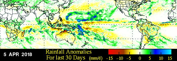
30 day ESPI is a bit below -1. ENSO region seems a bit dry but enhanced convection not far away. WPAC wet anomalies likely contributing

Image
0 likes   
This post was probably an opinion of mine, and in no way is official. Please refer to http://www.hurricanes.gov for official tropical analysis and advisories.

My website, with lots of tropical wx graphics, including satellite and recon: http://cyclonicwx.com

User avatar
NotSparta
Professional-Met
Professional-Met
Posts: 1660
Age: 22
Joined: Fri Aug 18, 2017 8:24 am
Location: Naples, FL
Contact:

Re: ENSO: ONI for JFM up to -0.8C

#9093 Postby NotSparta » Fri Apr 06, 2018 7:27 pm

NDG wrote:
Kingarabian wrote:
NDG wrote:
By this time in 2006 & 2009 Nino 3.4 was rapidly warming up into cool neutral zone and warm neutral by early May.


If you look at my previous post of the buoys, 2006, and 2009 are behind 2018 at this present time. We're approaching warm-neutral quicker than 2006 and 2009.


I was going by the CPC's weekly Nino 3.4 SSTs official readings.

29MAR2006 27.0-0.5
05APR2006 27.3-0.3
12APR2006 27.7 0.0
17MAY2006 28.1 0.2

25MAR2009 26.8-0.6
01APR2009 27.1-0.4
08APR2009 27.4-0.2
06MAY2009 27.9 0.1


28MAR2018 26.7-0.7

Latest CPC Niño 3.4 weekly slightly cooler than closest days of both those years. We'll see what the next weekly shows
0 likes   
This post was probably an opinion of mine, and in no way is official. Please refer to http://www.hurricanes.gov for official tropical analysis and advisories.

My website, with lots of tropical wx graphics, including satellite and recon: http://cyclonicwx.com

User avatar
cycloneye
Admin
Admin
Posts: 139593
Age: 67
Joined: Thu Oct 10, 2002 10:54 am
Location: San Juan, Puerto Rico

Re: ENSO Updates

#9094 Postby cycloneye » Sat Apr 07, 2018 6:18 am

The April 3 update of the subsurface waters shows the warm pool continuing to creep eastward (leading edge around 110W) and getting closer to surface but still there are some cooler waters to contend.

Image
1 likes   
Visit the Caribbean-Central America Weather Thread where you can find at first post web cams,radars
and observations from Caribbean basin members Click Here

User avatar
Kingarabian
S2K Supporter
S2K Supporter
Posts: 15461
Joined: Sat Aug 08, 2009 3:06 am
Location: Honolulu, Hawaii

Re: ENSO Updates

#9095 Postby Kingarabian » Sat Apr 07, 2018 2:07 pm

Per CDAS, looks like Nino 3.4 is higher this week, at -0.430

Not too far off from the buoys:

Image
2 likes   
RIP Kobe Bryant

User avatar
cycloneye
Admin
Admin
Posts: 139593
Age: 67
Joined: Thu Oct 10, 2002 10:54 am
Location: San Juan, Puerto Rico

Re: ENSO Updates

#9096 Postby cycloneye » Sat Apr 07, 2018 6:19 pm

Very interesting from Webb.

@webberweather
For 2 Ninos of the same caliber, ones that start in the CP & build east are more effective @ triggering non-linear, coupled feedbacks off the bat that are critical for growth. May be another reason why last yr's NINO attempt failed. Eq Pacific couldn't be more different this yr


@webberweather
Plus the warm pool is deeper in the west, increasing the potential longevity of the feedbacks in the CP. Aside from any AGW influence, I think this could be another good reason why most El Ninos since 1976 have been observed to start near the dateline and not South America


 https://twitter.com/webberweather/status/982757039146455040


 https://twitter.com/webberweather/status/982758883939799040


1 likes   
Visit the Caribbean-Central America Weather Thread where you can find at first post web cams,radars
and observations from Caribbean basin members Click Here

Digital-TC-Chaser

Re: ENSO Updates

#9097 Postby Digital-TC-Chaser » Sat Apr 07, 2018 6:45 pm

3 likes   

User avatar
cycloneye
Admin
Admin
Posts: 139593
Age: 67
Joined: Thu Oct 10, 2002 10:54 am
Location: San Juan, Puerto Rico

Re: ENSO Updates

#9098 Postby cycloneye » Sat Apr 07, 2018 6:51 pm

:uarrow: It will be an important week that culminates with the 12th CPC complete update. We will have plenty of information to digest.
1 likes   
Visit the Caribbean-Central America Weather Thread where you can find at first post web cams,radars
and observations from Caribbean basin members Click Here

User avatar
Kingarabian
S2K Supporter
S2K Supporter
Posts: 15461
Joined: Sat Aug 08, 2009 3:06 am
Location: Honolulu, Hawaii

Re: ENSO Updates

#9099 Postby Kingarabian » Sat Apr 07, 2018 7:34 pm

Taking a look at the 850 MB wind forecasts from the CFS and Euro:

CFSv2 has westerly wind anomalies in the eastern pacific continuing for most of April.

Image

Euro/EPS keeps trades relaxed across the eastern Pacific, before another huge WWB forms just west or over the dateline:

Image
4 likes   
RIP Kobe Bryant

Digital-TC-Chaser

Re: ENSO Updates

#9100 Postby Digital-TC-Chaser » Sun Apr 08, 2018 9:58 pm

Image

Image


Boms poama / projections lime = easterly anoms; Red=westerly anoms.
Last edited by Digital-TC-Chaser on Thu Apr 12, 2018 1:32 am, edited 1 time in total.
1 likes   


Return to “Talkin' Tropics”

Who is online

Users browsing this forum: Cdenton12, Emmett_Brown, floridasun, Google [Bot], LarryWx, skyline385, StormWeather, Wampadawg, Zonacane and 110 guests