2024 Global Model Runs Discussion (Out thru day 16)
Moderator: S2k Moderators
Forum rules

The posts in this forum are NOT official forecasts and should not be used as such. They are just the opinion of the poster and may or may not be backed by sound meteorological data. They are NOT endorsed by any professional institution or STORM2K. For official information, please refer to products from the National Hurricane Center and National Weather Service.
-
toad strangler

- S2K Supporter

- Posts: 4546
- Joined: Sun Jul 28, 2013 3:09 pm
- Location: Earth
- Contact:
Re: 2024 Global Model Runs Discussion (Out thru day 16)
12z EPS shows multiple LP in the W,N, and E Gulf. Bahamas and just N of Cuba too. At about 8-10 day range.
Last edited by toad strangler on Sat Aug 17, 2024 1:52 pm, edited 1 time in total.
2 likes
My Weather Station
https://www.wunderground.com/dashboard/pws/KFLPORTS603
https://www.wunderground.com/dashboard/pws/KFLPORTS603
-
TomballEd
- Category 5

- Posts: 1261
- Age: 62
- Joined: Wed Aug 16, 2023 4:52 pm
- Location: Spring/Klein area, not Tomball
Re: 2024 Global Model Runs Discussion (Out thru day 16)
Climatology says the season should get more active, and I'm sure it will. Day 15 GFS ensembles show 3 members with significant TCs that are close enough together, forming N/NE of the Greater Antilles, to possible mean some members are picking up on the same disturbance. Randomly scattered 1012 and 1014 mb "lows" across the MDR is not a meaningful symbol of anything. The models or ensembles showing something at the end of their range, that disappears, with a new storm location somewhere else (people posting the ICON storm of the run is an example of random systems popping up in random places with each run), is not a signal, except that no storms on any model or ensembles run across the models is a sign things are generally unfavorable.
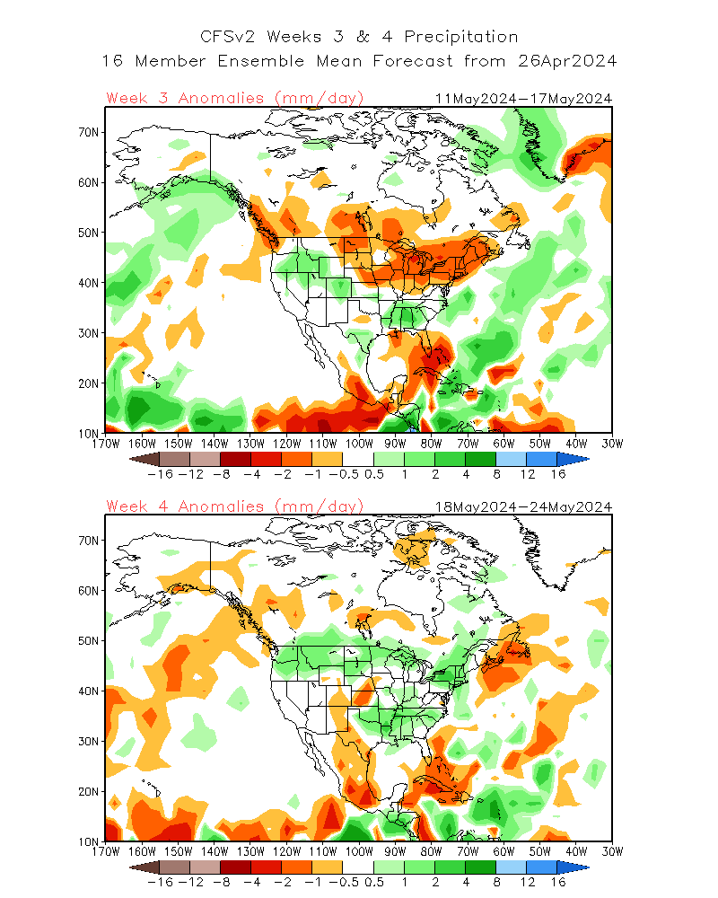
I expect more of a dimmer switch being turned up than a miraculous flip of a switch to 2 or 3 storms each week. I see enough between today's GEFS 3 systems, and the systems in fair proximity on earlier EPS runs, there probably will be another storm, and potentially close to land, near the very end of the month. I know people want there to be storms, and will even criticize a professional met for noting the pattern in the near future doesn't target them for a TC. On other place to look in a week, since MDR looks fairly slow for the end of August, is a short fuse TC along a decaying from that may hang around the E Gulf and off SEUSA. That may be what ICON used to spin up its weak Gulf low a couple of runs ago. CFS weeklies show that area with enhanced rainfall end of August and early September.
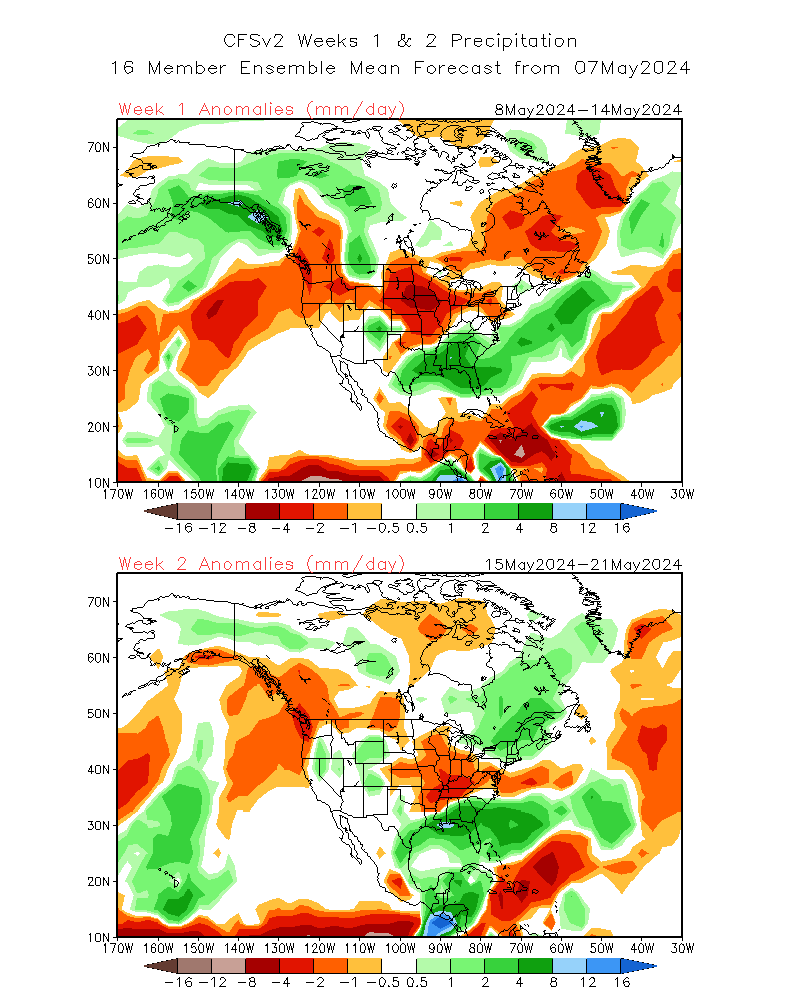
Week 3 and 4 are beyond the 16 days, but the week 2 area of precip near the SE US continues into week 3.
I expect more of a dimmer switch being turned up than a miraculous flip of a switch to 2 or 3 storms each week. I see enough between today's GEFS 3 systems, and the systems in fair proximity on earlier EPS runs, there probably will be another storm, and potentially close to land, near the very end of the month. I know people want there to be storms, and will even criticize a professional met for noting the pattern in the near future doesn't target them for a TC. On other place to look in a week, since MDR looks fairly slow for the end of August, is a short fuse TC along a decaying from that may hang around the E Gulf and off SEUSA. That may be what ICON used to spin up its weak Gulf low a couple of runs ago. CFS weeklies show that area with enhanced rainfall end of August and early September.
Week 3 and 4 are beyond the 16 days, but the week 2 area of precip near the SE US continues into week 3.
3 likes
-
Stratton23
- Category 5
- Posts: 3517
- Joined: Fri Jul 21, 2023 10:59 pm
- Location: Katy, Tx
Re: 2024 Global Model Runs Discussion (Out thru day 16)
both the GFS and Euro are starting to sniff out some tropical trouble in the gulf in about 10 days as well
1 likes
-
TomballEd
- Category 5
- Posts: 1261
- Age: 62
- Joined: Wed Aug 16, 2023 4:52 pm
- Location: Spring/Klein area, not Tomball
Re: 2024 Global Model Runs Discussion (Out thru day 16)
toad strangler wrote:12z EPS shows multiple LP in the W,N, and E Gulf. Bahamas and just N of Cuba too. At about 8-10 day range.
I can't see that yet, are any clustered, close enough together that some of the ECEN members are seeing the same thing? I was just talking about that, I am finally seeing in today's GFS ensembles and earlier ECENS a hint of something either side of the Greater Antilles out beyond 10 days.
0 likes
-
TomballEd
- Category 5
- Posts: 1261
- Age: 62
- Joined: Wed Aug 16, 2023 4:52 pm
- Location: Spring/Klein area, not Tomball
Re: 2024 Global Model Runs Discussion (Out thru day 16)
TomballEd wrote:toad strangler wrote:12z EPS shows multiple LP in the W,N, and E Gulf. Bahamas and just N of Cuba too. At about 8-10 day range.
I can't see that yet, are any clustered, close enough together that some of the ECEN members are seeing the same thing? I was just talking about that, I am finally seeing in today's GFS ensembles and earlier ECENS a hint of something either side of the Greater Antilles out beyond 10 days.
My bad, that question is answered in the post. So finally, a signal for something before August ends.
0 likes
-
toad strangler
- S2K Supporter
- Posts: 4546
- Joined: Sun Jul 28, 2013 3:09 pm
- Location: Earth
- Contact:
Re: 2024 Global Model Runs Discussion (Out thru day 16)
TomballEd wrote:TomballEd wrote:toad strangler wrote:12z EPS shows multiple LP in the W,N, and E Gulf. Bahamas and just N of Cuba too. At about 8-10 day range.
I can't see that yet, are any clustered, close enough together that some of the ECEN members are seeing the same thing? I was just talking about that, I am finally seeing in today's GFS ensembles and earlier ECENS a hint of something either side of the Greater Antilles out beyond 10 days.
My bad, that question is answered in the post. So finally, a signal for something before August ends.
Nah not clusterd tight. I see 4 that look like something is up. Scattered across the N & E GOM / N of Cuba / in Bahamas
2 likes
My Weather Station
https://www.wunderground.com/dashboard/pws/KFLPORTS603
https://www.wunderground.com/dashboard/pws/KFLPORTS603
-
Stratton23
- Category 5
- Posts: 3517
- Joined: Fri Jul 21, 2023 10:59 pm
- Location: Katy, Tx
Re: 2024 Global Model Runs Discussion (Out thru day 16)
The focus may need to shift to the gulf of mexico in the next 7-14 days for some home grown development, the GFS and Euro are showing multiple disturbances passing through the incredibly warm waters of the gulf, both hint at development, this is something that is going to be needing to be watched very closely as we go forward
3 likes
-
skyline385

- Category 5
- Posts: 2728
- Age: 35
- Joined: Wed Aug 26, 2020 11:15 pm
- Location: Houston TX
Re: 2024 Global Model Runs Discussion (Out thru day 16)
You cant get more agreement than this between both ensembles for a long range signal, the wave should be coming off Africa in the next 5-7 days.


8 likes
-
otowntiger
- Category 5
- Posts: 1932
- Joined: Tue Aug 31, 2004 7:06 pm
Re: 2024 Global Model Runs Discussion (Out thru day 16)
of course it’s way early but certainly both of those models suites predominantly depict a strong recurve pattern. I guess they are picking up on the Bermuda high now not being so strong. Interesting flip from earlier indications.skyline385 wrote:You cant get more agreement than this between both ensembles for a long range signal, the wave should be coming off Africa in the next 5-7 days.
https://i.imgur.com/UVq5UEm.png
https://i.imgur.com/2t8Oji2.png
0 likes
-
Category5Kaiju

- Category 5
- Posts: 4330
- Joined: Thu Dec 24, 2020 12:45 pm
- Location: Seattle and Phoenix
Re: 2024 Global Model Runs Discussion (Out thru day 16)
otowntiger wrote:of course it’s way early but certainly both of those models suites predominantly depict a strong recurve pattern. I guess they are picking up on the Bermuda high now not being so strong. Interesting flip from earlier indications.skyline385 wrote:You cant get more agreement than this between both ensembles for a long range signal, the wave should be coming off Africa in the next 5-7 days.
https://i.imgur.com/UVq5UEm.png
https://i.imgur.com/2t8Oji2.png
I mean, how do we know as of now that they wouldn't hit the Eastern Seabooard, for example? Seems like the models end with a cliffhanger in that sense
1 likes
Unless explicitly stated, all info in my posts is based on my own opinions and observations. Tropical storms and hurricanes can be extremely dangerous. Refer to an accredited weather research agency or meteorologist if you need to make serious decisions regarding an approaching storm.

Re: 2024 Global Model Runs Discussion (Out thru day 16)
otowntiger wrote:of course it’s way early but certainly both of those models suites predominantly depict a strong recurve pattern. I guess they are picking up on the Bermuda high now not being so strong. Interesting flip from earlier indications.skyline385 wrote:You cant get more agreement than this between both ensembles for a long range signal, the wave should be coming off Africa in the next 5-7 days.
https://i.imgur.com/UVq5UEm.png
https://i.imgur.com/2t8Oji2.png
The earliest signals for Irma were just like this. Then they became a Carolinas landfall, then Florida east coast, and finally Florida west coast.
2 likes
TC naming lists: retirements and intensity
Most aggressive Advisory #1's in North Atlantic (cr. kevin for starting the list)
Most aggressive Advisory #1's in North Atlantic (cr. kevin for starting the list)
-
Category5Kaiju
- Category 5
- Posts: 4330
- Joined: Thu Dec 24, 2020 12:45 pm
- Location: Seattle and Phoenix
Re: 2024 Global Model Runs Discussion (Out thru day 16)
Teban54 wrote:otowntiger wrote:of course it’s way early but certainly both of those models suites predominantly depict a strong recurve pattern. I guess they are picking up on the Bermuda high now not being so strong. Interesting flip from earlier indications.skyline385 wrote:You cant get more agreement than this between both ensembles for a long range signal, the wave should be coming off Africa in the next 5-7 days.
https://i.imgur.com/UVq5UEm.png
https://i.imgur.com/2t8Oji2.png
The earliest signals for Irma were just like this. Then they became a Carolinas landfall, then Florida east coast, and finally Florida west coast.
Same for Florence too. A Cape Verde storm that goes north of the Caribbean is pretty tricky to forecast this early regarding if it's a true OTS storm or if it manages to end up further west.
1 likes
Unless explicitly stated, all info in my posts is based on my own opinions and observations. Tropical storms and hurricanes can be extremely dangerous. Refer to an accredited weather research agency or meteorologist if you need to make serious decisions regarding an approaching storm.
-
Stratton23
- Category 5
- Posts: 3517
- Joined: Fri Jul 21, 2023 10:59 pm
- Location: Katy, Tx
Re: 2024 Global Model Runs Discussion (Out thru day 16)
otowntiger not so fast, the EPS has a well known biacy of developing tropical systems too fast off of africa and turning them out to sea, the pattern ahead points to a +NAO becoming firmly entrenched over the eastern us/atlantic, thats not a recurve pattern at all
0 likes
Re: 2024 Global Model Runs Discussion (Out thru day 16)
otowntiger wrote:of course it’s way early but certainly both of those models suites predominantly depict a strong recurve pattern. I guess they are picking up on the Bermuda high now not being so strong. Interesting flip from earlier indications.skyline385 wrote:You cant get more agreement than this between both ensembles for a long range signal, the wave should be coming off Africa in the next 5-7 days.
https://i.imgur.com/UVq5UEm.png
https://i.imgur.com/2t8Oji2.png
Yes, I agree it’s way early. Nobody even knows if anything will even develop far enough E, if at all, from that AEW to have the chance to recurve early. But this AEW leaving Africa ~8/24 has been one of the ones most harped on by a good number of GEFS/EPS ensemble members for several days now. So, it wouldn’t surprise me if it produces a TC.
As we get closer we’ll get a better idea about this. And then we can see how far E it will form if at all. The further E it forms, the better chance (though far from a guarantee obviously) for an early recurve even during La Niña. But if it waits too long (unfortunately that’s what models are suggesting if it develops) and then becomes a TC, that becomes the most dangerous option for anyone in the Caribbean or W basin, especially with the current RONI based La Niña.
0 likes
Personal Forecast Disclaimer:
The posts in this forum are NOT official forecasts and should not be used as such. They are just the opinion of the poster and may or may not be backed by sound meteorological data. They are NOT endorsed by any professional institution or storm2k.org. For official information, please refer to the NHC and NWS products.
The posts in this forum are NOT official forecasts and should not be used as such. They are just the opinion of the poster and may or may not be backed by sound meteorological data. They are NOT endorsed by any professional institution or storm2k.org. For official information, please refer to the NHC and NWS products.
-
otowntiger
- Category 5
- Posts: 1932
- Joined: Tue Aug 31, 2004 7:06 pm
Re: 2024 Global Model Runs Discussion (Out thru day 16)
Stratton23 wrote:otowntiger not so fast, the EPS has a well known biacy of developing tropical systems too fast off of africa and turning them out to sea, the pattern ahead points to a +NAO becoming firmly entrenched over the eastern us/atlantic, thats not a recurve pattern at all
Just commenting on what those graphics are depicting. But a lot can change and there is a lot more going on than meets the eye as you indicate. One thing I do know is that climatologically speaking, storms in the Atlantic recurve more often than they don’t.
1 likes
-
wxman57

- Moderator-Pro Met

- Posts: 23171
- Age: 68
- Joined: Sat Jun 21, 2003 8:06 pm
- Location: Houston, TX (southwest)
Re: 2024 Global Model Runs Discussion (Out thru day 16)
Having to look for the odd ensemble member to identify development shows just how unfavorable the environment is. To reach 25 named storms, we'd need to see an explosion of storms the next 3 months that we've never seen in the past. Sub-20 looks quite likely. My 17/8/4 isn't looking too bad in our office contest, though I'm hoping for even less activity. Taking another comp day off tomorrow and probably Friday. Enjoying the break in storms.
8 likes

Re: 2024 Global Model Runs Discussion (Out thru day 16)
wxman57 wrote:Having to look for the odd ensemble member to identify development shows just how unfavorable the environment is. To reach 25 named storms, we'd need to see an explosion of storms the next 3 months that we've never seen in the past. Sub-20 looks quite likely. My 17/8/4 isn't looking too bad in our office contest, though I'm hoping for even less activity. Taking another comp day off tomorrow and probably Friday. Enjoying the break in storms.
It is a bit ominous for Atlantic activity that the east Pacific has now flared up with four areas of potential development over the next week. Normally the Atlantic and east Pacific basins are in anti-phase which implies not much happening in the Atlantic in the short term at least. I'm starting to wonder if this is going to be another weather trolling year where tropical cyclone behaviour completely defies the climatology signals that have worked over the last 60 years at least.
6 likes
-
REDHurricane

- Category 1

- Posts: 438
- Age: 28
- Joined: Sun Jul 03, 2022 2:36 pm
- Location: Northeast Pacific Ocean
Re: 2024 Global Model Runs Discussion (Out thru day 16)
al78 wrote:wxman57 wrote:Having to look for the odd ensemble member to identify development shows just how unfavorable the environment is. To reach 25 named storms, we'd need to see an explosion of storms the next 3 months that we've never seen in the past. Sub-20 looks quite likely. My 17/8/4 isn't looking too bad in our office contest, though I'm hoping for even less activity. Taking another comp day off tomorrow and probably Friday. Enjoying the break in storms.
It is a bit ominous for Atlantic activity that the east Pacific has now flared up with four areas of potential development over the next week. Normally the Atlantic and east Pacific basins are in anti-phase which implies not much happening in the Atlantic in the short term at least. I'm starting to wonder if this is going to be another weather trolling year where tropical cyclone behaviour completely defies the climatology signals that have worked over the last 60 years at least.
I still think this is a little bit premature, no? Certainly it's possible that this hurricane season will be an anomaly compared to what several decades worth of climatology data would suggest, but this is unlikely by definition, and plus it's not even August 20th yet. So what if the peak of activity gets pushed back 7-10 days later than usual -- would it not be possible for the season to end 7-10 days later than usual then? If I'm not mistaken, in recent years there's been more of a trend towards backloaded seasons anyway, so the fact that there's been a relative lack of activity (category 2 MDR hurricane that literally just made landfall in Bermuda notwithstanding) and models are showing weak signals for development through the end of August (a month in which there are still almost 13 days to go; if the GFS was forecasting a category 5 in the Gulf 13 days out instead of no activity, everyone would rightly take it with a huge grain of salt at the very best) doesn't mean that we should start doubting all of the high seasonal forecast numbers when all of the usual indicators of a very favorable environment for TC development are still present and will in all likelihood persist through the end of November.
Regarding the EPac activity, haven't there been other instances where the EPac will light up for a week or so and then the favorability (MJO phase, Kelvin wave, etc.) shifts over to the east to initiate an outbreak of activity in the Atlantic basin? Legitimately asking here, I have no idea what the actual data says about this so I'd be glad to learn more about it if anyone knows/wants to explain.
Either way though, my non-expert opinion is that talk of "season cancelling" before the end of August (and especially before August 20th) has less to do with what's actually going to happen over the next 3 months and more to do with a bunch of bored weather professionals/enthusiasts (myself included) who have been constantly monitoring the tropics for almost 6 weeks straight without the appearance of a major hurricane and/or successive bursts of named storms despite the anticipation of constant TC activity from the beginning of August to the end of November created by the consensus record-high seasonal predictions. At least in my view, nothing has changed that would suggest that the Atlantic will not produce a hyperactive hurricane season overall... now if 2 weeks from today no additional activity has occurred or is forecast to occur soon, that's an entirely different discussion where it would much more reasonable to jump on the "season cancel" train, but I don't need professional experience to know that 2 weeks is a long time in the tropics and that model forecasts 7+ days out have little merit this time of year regardless.
If the hurricane season measured by activity level took place over the span of one week (Monday-Sunday), we wouldn't even be done with Tuesday yet!
7 likes
-
TomballEd
- Category 5
- Posts: 1261
- Age: 62
- Joined: Wed Aug 16, 2023 4:52 pm
- Location: Spring/Klein area, not Tomball
Re: 2024 Global Model Runs Discussion (Out thru day 16)
wxman57 wrote:Having to look for the odd ensemble member to identify development shows just how unfavorable the environment is. To reach 25 named storms, we'd need to see an explosion of storms the next 3 months that we've never seen in the past. Sub-20 looks quite likely. My 17/8/4 isn't looking too bad in our office contest, though I'm hoping for even less activity. Taking another comp day off tomorrow and probably Friday. Enjoying the break in storms.
The professional here notes what I have been trying to say, random lows beyond 10 days that are scattered and change each run aren't a strong signal. Especially when they are 1009 mb or 1012 mb.
End of range, but Euro shows as well to a lesser extent, a suggestion that the WATL might at least be not hostile for TC development in 2 weeks. The three NE of the Caribbean may show that 3 different members are seeing the same thing. If GFS ensemble mean heights are right, "fish" is not guaranteed at all.


The images don't show up on preview. I have yet to figure out why it works sometimes and why its doesn't. 360 hour individual ensemble member lows and 500 mb normalized anomaly from Tropical Tidbits if you want to look.
0 likes
-
SFLcane

- S2K Supporter
- Posts: 10281
- Age: 48
- Joined: Sat Jun 05, 2010 1:44 pm
- Location: Lake Worth Florida
Re: 2024 Global Model Runs Discussion (Out thru day 16)
REDHurricane wrote:al78 wrote:wxman57 wrote:Having to look for the odd ensemble member to identify development shows just how unfavorable the environment is. To reach 25 named storms, we'd need to see an explosion of storms the next 3 months that we've never seen in the past. Sub-20 looks quite likely. My 17/8/4 isn't looking too bad in our office contest, though I'm hoping for even less activity. Taking another comp day off tomorrow and probably Friday. Enjoying the break in storms.
It is a bit ominous for Atlantic activity that the east Pacific has now flared up with four areas of potential development over the next week. Normally the Atlantic and east Pacific basins are in anti-phase which implies not much happening in the Atlantic in the short term at least. I'm starting to wonder if this is going to be another weather trolling year where tropical cyclone behaviour completely defies the climatology signals that have worked over the last 60 years at least.
I still think this is a little bit premature, no? Certainly it's possible that this hurricane season will be an anomaly compared to what several decades worth of climatology data would suggest, but this is unlikely by definition, and plus it's not even August 20th yet. So what if the peak of activity gets pushed back 7-10 days later than usual -- would it not be possible for the season to end 7-10 days later than usual then? If I'm not mistaken, in recent years there's been more of a trend towards backloaded seasons anyway, so the fact that there's been a relative lack of activity (category 2 MDR hurricane that literally just made landfall in Bermuda notwithstanding) and models are showing weak signals for development through the end of August (a month in which there are still almost 13 days to go; if the GFS was forecasting a category 5 in the Gulf 13 days out instead of no activity, everyone would rightly take it with a huge grain of salt at the very best) doesn't mean that we should start doubting all of the high seasonal forecast numbers when all of the usual indicators of a very favorable environment for TC development are still present and will in all likelihood persist through the end of November.
Regarding the EPac activity, haven't there been other instances where the EPac will light up for a week or so and then the favorability (MJO phase, Kelvin wave, etc.) shifts over to the east to initiate an outbreak of activity in the Atlantic basin? Legitimately asking here, I have no idea what the actual data says about this so I'd be glad to learn more about it if anyone knows/wants to explain.
Either way though, my non-expert opinion is that talk of "season cancelling" before the end of August (and especially before August 20th) has less to do with what's actually going to happen over the next 3 months and more to do with a bunch of bored weather professionals/enthusiasts (myself included) who have been constantly monitoring the tropics for almost 6 weeks straight without the appearance of a major hurricane and/or successive bursts of named storms despite the anticipation of constant TC activity from the beginning of August to the end of November created by the consensus record-high seasonal predictions. At least in my view, nothing has changed that would suggest that the Atlantic will not produce a hyperactive hurricane season overall... now if 2 weeks from today no additional activity has occurred or is forecast to occur soon, that's an entirely different discussion where it would much more reasonable to jump on the "season cancel" train, but I don't need professional experience to know that 2 weeks is a long time in the tropics and that model forecasts 7+ days out have little merit this time of year regardless.
If the hurricane season measured by activity level took place over the span of one week (Monday-Sunday), we wouldn't even be done with Tuesday yet!
Great post!
2 likes
Who is online
Users browsing this forum: ljmac75 and 163 guests