

Top hurricane sat photos of all time...
Moderator: S2k Moderators
Forum rules

The posts in this forum are NOT official forecasts and should not be used as such. They are just the opinion of the poster and may or may not be backed by sound meteorological data. They are NOT endorsed by any professional institution or STORM2K. For official information, please refer to products from the National Hurricane Center and National Weather Service.
-
mrbagyo

- Category 5

- Posts: 3614
- Age: 31
- Joined: Thu Apr 12, 2012 9:18 am
- Location: 14.13N 120.98E
- Contact:
Re: Top hurricane sat photos of all time...
Another Landsat-8 sat image before Hurricane Ian's landfall

6 likes
The posts in this forum are NOT official forecast and should not be used as such. They are just the opinion of the poster and may or may not be backed by sound meteorological data. They are NOT endorsed by any professional institution or storm2k.org. For official information, please refer to RSMC, NHC and NWS products.

Re: Top hurricane sat photos of all time...
I found this picture of a bunch of pictures of Typhoon Rita from the 23rd to late on the 24th of October 1978. Unfortunately, I don't think these pictures are available for the 25th, around its peak.
Again, I'm not going to bother looking through the 24-page thread to see if it had already been posted, and either way everyone's probably forgotten by then.

It's from Wikipedia and source is stated as Mariners Weather Log Sep 1979 pg. 321 but I swear I've looked up and down the volumes around 1978-1979 and I can't find it.
Edit: I forgot about the gif that seems to have been made from those pictures. I have no idea how to upload gifs here though so you get the link.
Edit 2: I never actually stated what was significant about this storm. Rita '78 was one of the most intense TCs on record with the lowest recorded central pressure being 878mb. The storm also sustained a pressure of 900mb or lower for ~3.5 days.
Again, I'm not going to bother looking through the 24-page thread to see if it had already been posted, and either way everyone's probably forgotten by then.
It's from Wikipedia and source is stated as Mariners Weather Log Sep 1979 pg. 321 but I swear I've looked up and down the volumes around 1978-1979 and I can't find it.
Edit: I forgot about the gif that seems to have been made from those pictures. I have no idea how to upload gifs here though so you get the link.
Edit 2: I never actually stated what was significant about this storm. Rita '78 was one of the most intense TCs on record with the lowest recorded central pressure being 878mb. The storm also sustained a pressure of 900mb or lower for ~3.5 days.
Last edited by Foxfires on Fri Jan 27, 2023 6:38 am, edited 1 time in total.
4 likes
Re: Top hurricane sat photos of all time...
While the storm below is quite photogenic regardless of its context, I would also like to point out the latitude of such a good looking storm.
Typhoon Bopha 2012 at category 4 intensity. RI & RD to get to this (according to agency estimates), which was still <5N. Really tells you how extreme some storms can be.

I got this from the Bopha thread on this site.
Typhoon Bopha 2012 at category 4 intensity. RI & RD to get to this (according to agency estimates), which was still <5N. Really tells you how extreme some storms can be.
I got this from the Bopha thread on this site.
6 likes
-
Category5Kaiju

- Category 5
- Posts: 3357
- Age: 22
- Joined: Thu Dec 24, 2020 12:45 pm
- Location: Seattle
Re: Top hurricane sat photos of all time...

You know, Cyclone Ambali from late 2019 looked pretty darn good despite being a very small cyclone
0 likes
Unless explicitly stated, all information covered in my posts is based on my opinions and observations. Please refer to a professional meteorologist or an accredited weather research agency otherwise, especially if serious decisions must be made in the event of a potentially life-threatening tropical storm or hurricane.


Re: Top hurricane sat photos of all time...
Supertyphoon Mawar
Image is from 5 hours ago, just before sunset (910 mb, 145 kt).

Image is from 5 hours ago, just before sunset (910 mb, 145 kt).
3 likes
-
mrbagyo
- Category 5
- Posts: 3614
- Age: 31
- Joined: Thu Apr 12, 2012 9:18 am
- Location: 14.13N 120.98E
- Contact:
Re: Top hurricane sat photos of all time...
Super Typhoon Mawar
NOAA 20

NOAA 20
5 likes
The posts in this forum are NOT official forecast and should not be used as such. They are just the opinion of the poster and may or may not be backed by sound meteorological data. They are NOT endorsed by any professional institution or storm2k.org. For official information, please refer to RSMC, NHC and NWS products.

Re: Top hurricane sat photos of all time...
Foxfires wrote:I found this picture of a bunch of pictures of Typhoon Rita from the 23rd to late on the 24th of October 1978. Unfortunately, I don't think these pictures are available for the 25th, around its peak.
Again, I'm not going to bother looking through the 24-page thread to see if it had already been posted, and either way everyone's probably forgotten by then.
https://upload.wikimedia.org/wikipedia/commons/7/76/Typhoon_Rita-Timeline.png
It's from Wikipedia and source is stated as Mariners Weather Log Sep 1979 pg. 321 but I swear I've looked up and down the volumes around 1978-1979 and I can't find it.
Edit: I forgot about the gif that seems to have been made from those pictures. I have no idea how to upload gifs here though so you get the link.
Edit 2: I never actually stated what was significant about this storm. Rita '78 was one of the most intense TCs on record with the lowest recorded central pressure being 878mb. The storm also sustained a pressure of 900mb or lower for ~3.5 days.
Apparently this image is from 10/25/1978...

Found within the wikipedia commons, and that eye looks so potent, 878mb worthy!
Source cited as: Mariners Weather Log, September 1979, pg. 320
2 likes
Georges '98, Irene '99, Frances '04, Jeanne '04, Katrina '05, Wilma '05, Gustav '08, Isaac '12, Matthew '16, Florence '18, Michael '18, Ian '22

-
cheezyWXguy

- Category 5
- Posts: 5528
- Joined: Mon Feb 13, 2006 12:29 am
- Location: Dallas, TX
Re: Top hurricane sat photos of all time...
Teban54 wrote:Franklin 2023
https://i.postimg.cc/cCQbv9gG/20232402150-GOES16-ABI-FL-GEOCOLOR-AL082023-2000x2000.jpg
High-res: https://imgur.com/a/A4KK7R2
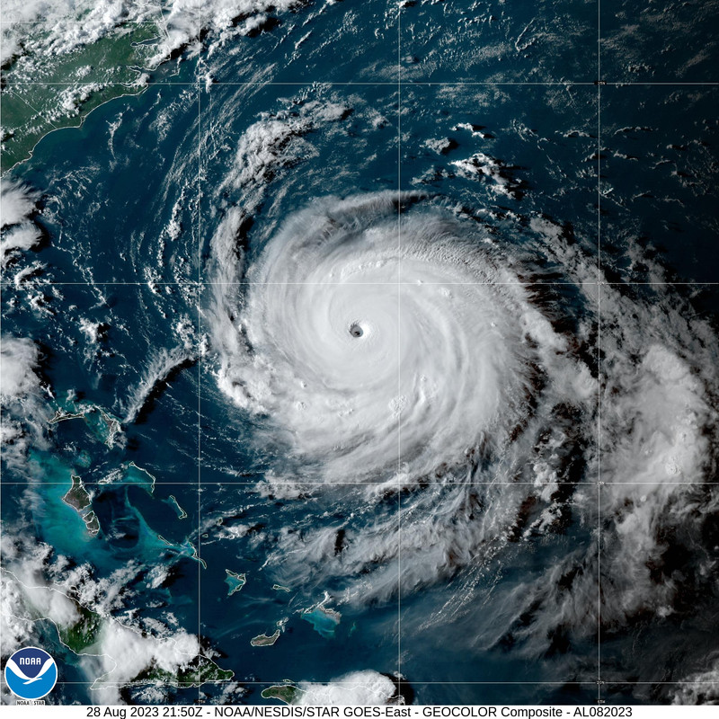
I’m simultaneously amazed at how much Franklin exceeded expectations and almost disappointed it didn’t quite make cat5, given how perfect it looked here. Talk about symmetry
3 likes
Re: Top hurricane sat photos of all time...
I'm not sure how to post an image, but 3 storms come to mind, the first is Hurricane Carla, radar in 1961 was not like today's radar, but I always thought the image of Carla's outer bands, coming into radar range were cool, the second is Hurricane Allen, biggesr cyclone I ever saw, filled up the entire gulf, the third is Hurricane Gilbert, I always considered Gilbert to be much like Allen, just a monster storm. I'm sorry I couldn't post the images, maybe one of yall can help me out!....peace everyone...
0 likes
-
Iceresistance

- Category 5
- Posts: 8911
- Age: 20
- Joined: Sat Oct 10, 2020 9:45 am
- Location: Tecumseh, OK/Norman, OK
Re: Top hurricane sat photos of all time...
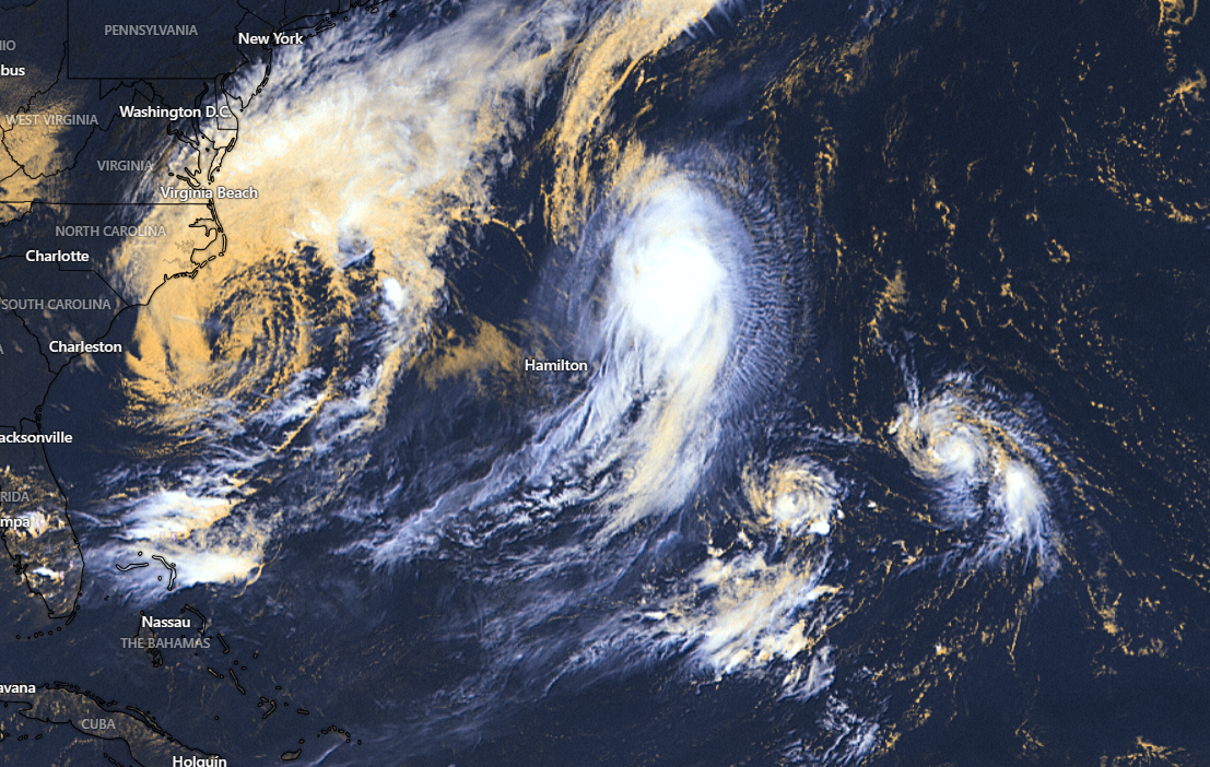
The Quad in this picture
Idalia to the left, Franklin in the upper right center, Gert (Circulation) in the lower right center, and Jose to the right.
https://s11.gifyu.com/images/SgCyy.png
(Someone please save this to Imgur)
Idalia to the left, Franklin in the upper right center, Gert (Circulation) in the lower right center, and Jose to the right.
https://s11.gifyu.com/images/SgCyy.png
(Someone please save this to Imgur)
1 likes
Bill 2015 & Beta 2020
Winter 2020-2021
All observations are in Tecumseh, OK unless otherwise noted.
Winter posts are focused mainly for Oklahoma & Texas.
Take any of my forecasts with a grain of salt, refer to the NWS, SPC, and NHC for official information
Never say Never with weather! Because ANYTHING is possible!
Winter 2020-2021
All observations are in Tecumseh, OK unless otherwise noted.
Winter posts are focused mainly for Oklahoma & Texas.
Take any of my forecasts with a grain of salt, refer to the NWS, SPC, and NHC for official information
Never say Never with weather! Because ANYTHING is possible!
Re: Top hurricane sat photos of all time...
Hurricane Jova just before sunset. Maybe we can get an even more spectacular image at sunrise.

6 likes
-
Hurricane2022

- Category 4

- Posts: 919
- Joined: Tue Aug 23, 2022 11:38 pm
- Location: Araçatuba, Brazil
Re: Top hurricane sat photos of all time...
Incredible satellite images of Hurricane Jova - Part I
https://twitter.com/zeb199818/status/1699687934465921354
https://twitter.com/zeb199818/status/1699689028743012736
https://twitter.com/zeb199818/status/1699593177488085203
https://twitter.com/zeb199818/status/1699626255711363312
https://twitter.com/zeb199818/status/1699687934465921354
https://twitter.com/zeb199818/status/1699689028743012736
https://twitter.com/zeb199818/status/1699593177488085203
https://twitter.com/zeb199818/status/1699626255711363312
2 likes
Sorry for the bad English sometimes...!
For reliable and detailed information for any meteorological phenomenon, please consult the National Hurricane Center, Joint Typhoon Warning Center , or your local Meteo Center.
--------
Una cvm Christo, pro Christo, et in Christo. Sit nomen Domini benedictvm.
For reliable and detailed information for any meteorological phenomenon, please consult the National Hurricane Center, Joint Typhoon Warning Center , or your local Meteo Center.
--------
Una cvm Christo, pro Christo, et in Christo. Sit nomen Domini benedictvm.
-
Hurricane2022
- Category 4
- Posts: 919
- Joined: Tue Aug 23, 2022 11:38 pm
- Location: Araçatuba, Brazil
Re: Top hurricane sat photos of all time...
Incredible satellite images of Hurricane Jova - Part II
https://twitter.com/zoom_earth/status/1699762386612146179
https://twitter.com/NHC_TAFB/status/1699618732426014822
https://twitter.com/weatherffolkes/status/1699616628898501041
https://twitter.com/Storm_Chaser_75/status/1699618169596362814
https://twitter.com/zoom_earth/status/1699762386612146179
https://twitter.com/NHC_TAFB/status/1699618732426014822
https://twitter.com/weatherffolkes/status/1699616628898501041
https://twitter.com/Storm_Chaser_75/status/1699618169596362814
1 likes
Sorry for the bad English sometimes...!
For reliable and detailed information for any meteorological phenomenon, please consult the National Hurricane Center, Joint Typhoon Warning Center , or your local Meteo Center.
--------
Una cvm Christo, pro Christo, et in Christo. Sit nomen Domini benedictvm.
For reliable and detailed information for any meteorological phenomenon, please consult the National Hurricane Center, Joint Typhoon Warning Center , or your local Meteo Center.
--------
Una cvm Christo, pro Christo, et in Christo. Sit nomen Domini benedictvm.
-
Hurricane2022
- Category 4
- Posts: 919
- Joined: Tue Aug 23, 2022 11:38 pm
- Location: Araçatuba, Brazil
Re: Top hurricane sat photos of all time...
Incredible satellite images of Hurricane Jova - Part III
https://twitter.com/iCyclone/status/1699609709140181342
https://twitter.com/BenCohenTC/status/1699595001850700079
https://twitter.com/WxTca/status/1699593138346795101
https://twitter.com/DCAreaWx/status/1699586362003878063
https://twitter.com/iCyclone/status/1699609709140181342
https://twitter.com/BenCohenTC/status/1699595001850700079
https://twitter.com/WxTca/status/1699593138346795101
https://twitter.com/DCAreaWx/status/1699586362003878063
1 likes
Sorry for the bad English sometimes...!
For reliable and detailed information for any meteorological phenomenon, please consult the National Hurricane Center, Joint Typhoon Warning Center , or your local Meteo Center.
--------
Una cvm Christo, pro Christo, et in Christo. Sit nomen Domini benedictvm.
For reliable and detailed information for any meteorological phenomenon, please consult the National Hurricane Center, Joint Typhoon Warning Center , or your local Meteo Center.
--------
Una cvm Christo, pro Christo, et in Christo. Sit nomen Domini benedictvm.
-
Hurricane2022
- Category 4
- Posts: 919
- Joined: Tue Aug 23, 2022 11:38 pm
- Location: Araçatuba, Brazil
Re: Top hurricane sat photos of all time...
Incredible satellite images of Hurricane Jova - Part IV
https://twitter.com/Storm_Chaser_75/status/1699590571075965164
https://twitter.com/DrKimWood/status/1699585984462303363
https://twitter.com/xiaoqianWX/status/1699580348927984068
https://twitter.com/woodberrywx/status/1699578980003688516
https://twitter.com/WxTca/status/1699792660385652841
https://twitter.com/Storm_Chaser_75/status/1699590571075965164
https://twitter.com/DrKimWood/status/1699585984462303363
https://twitter.com/xiaoqianWX/status/1699580348927984068
https://twitter.com/woodberrywx/status/1699578980003688516
https://twitter.com/WxTca/status/1699792660385652841
1 likes
Sorry for the bad English sometimes...!
For reliable and detailed information for any meteorological phenomenon, please consult the National Hurricane Center, Joint Typhoon Warning Center , or your local Meteo Center.
--------
Una cvm Christo, pro Christo, et in Christo. Sit nomen Domini benedictvm.
For reliable and detailed information for any meteorological phenomenon, please consult the National Hurricane Center, Joint Typhoon Warning Center , or your local Meteo Center.
--------
Una cvm Christo, pro Christo, et in Christo. Sit nomen Domini benedictvm.
Re: Top hurricane sat photos of all time...
Unfortunately Lee's cat 5 peak was at night and I can't find any of the NOAA20 images which corrected IR to visible for that specific time period. But here's a night image of the rough time period when Lee had the highest raw T#.

5 likes
Re: Top hurricane sat photos of all time...
Lee at 0520z on September 8 (slightly after peak intensity in terms of ADT, 6.6 vs 7.0 at 2340z on September 7).

4 likes
Who is online
Users browsing this forum: AnnularCane, Google Adsense [Bot], Hurricane2022, KirbyDude25, NotSparta, USTropics and 181 guests