
http://www.sun-sentinel.com/news/weathe ... 2369.story
It came out just an hour ago. This is not talking about tammy, it is talking about another storm that they have just caught in re-analysis
EDIT: I emailed the NHC. Yes , it is official.
Email:
Hello Michael,
Yes, it is official. A TCR will be posted on the NHC website upon completion.
-NHC Public Affairs
New storm in 2011 reanalysis? Is this article accurate?
Moderator: S2k Moderators
Forum rules

The posts in this forum are NOT official forecasts and should not be used as such. They are just the opinion of the poster and may or may not be backed by sound meteorological data. They are NOT endorsed by any professional institution or STORM2K. For official information, please refer to products from the National Hurricane Center and National Weather Service.
New storm in 2011 reanalysis? Is this article accurate?
Last edited by Dean_175 on Mon Nov 21, 2011 9:57 pm, edited 2 times in total.
0 likes
All posts by Dean_175 are NOT official forecasts and should not be used as such. They are just the opinion of the poster and may or may not be backed by sound meteorological data. They are NOT endorsed by any professional institution or storm2k.org. For official information, please refer to the NHC and NWS products.
-
somethingfunny

- ChatStaff

- Posts: 3926
- Age: 37
- Joined: Thu May 31, 2007 10:30 pm
- Location: McKinney, Texas
Re: New storm in 2011 reanalysis? Is this article accurate?
Between Bermuda and Nova Scotia in early September? I'm not sure what they're referring to. It's not on the NHC's tropical cyclone reports page.
0 likes
I am not a meteorologist, and any posts made by me are not official forecasts or to be interpreted as being intelligent. These posts are just my opinions and are probably silly opinions.
-
Extratropical94

- Professional-Met

- Posts: 3545
- Age: 31
- Joined: Wed Oct 20, 2010 6:36 am
- Location: Hamburg, Germany
- Contact:
That must have been the system many of us complained about because it wasn't recognized even though it looked waaaay better than Jose.
I don't know the exact invest number though.
I don't know the exact invest number though.
0 likes
54° 11' 59'' N, 9° 9' 20'' E
Boomer Sooner!
Go Broncos! Go Cards!
Clinching counties, one at a time: https://mob-rule.com/user-gifs/USA/xtrp94.gif
- Daniel
Boomer Sooner!
Go Broncos! Go Cards!
Clinching counties, one at a time: https://mob-rule.com/user-gifs/USA/xtrp94.gif
- Daniel
-
wxman57

- Moderator-Pro Met

- Posts: 23175
- Age: 68
- Joined: Sat Jun 21, 2003 8:06 pm
- Location: Houston, TX (southwest)
Re:
Extratropical94 wrote:That must have been the system many of us complained about because it wasn't recognized even though it looked waaaay better than Jose.
I don't know the exact invest number though.
It appears to be a frontal low that formed ahead of Katia on the 1-2 of Sept.
0 likes
-
Extratropical94
- Professional-Met
- Posts: 3545
- Age: 31
- Joined: Wed Oct 20, 2010 6:36 am
- Location: Hamburg, Germany
- Contact:
Re: Re:
wxman57 wrote:Extratropical94 wrote:That must have been the system many of us complained about because it wasn't recognized even though it looked waaaay better than Jose.
I don't know the exact invest number though.
It appears to be a frontal low that formed ahead of Katia on the 1-2 of Sept. It never was an invest.
Yeah, you're right, that was the point we were talking about.
Well, I think if the NHC ups this one to a TS/STS, they could do the same with the frontal low directly after Franklin (the one which spawned from the same front).
0 likes
54° 11' 59'' N, 9° 9' 20'' E
Boomer Sooner!
Go Broncos! Go Cards!
Clinching counties, one at a time: https://mob-rule.com/user-gifs/USA/xtrp94.gif
- Daniel
Boomer Sooner!
Go Broncos! Go Cards!
Clinching counties, one at a time: https://mob-rule.com/user-gifs/USA/xtrp94.gif
- Daniel
-
Hurricanehink

- S2K Supporter

- Posts: 2046
- Joined: Sun Nov 16, 2003 2:05 pm
- Location: New Jersey
Re: New storm in 2011 reanalysis? Is this article accurate?
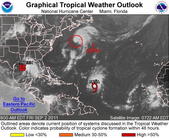
I believe it was this storm south of Nova Scotia

The NHC said this:
The NHC said this:
UPDATED...THE LOW PRESSURE SYSTEM LOCATED ABOUT 360 MILES NORTH
OF BERMUDA APPEARS TO BE ACQUIRING SOME TROPICAL CHARACTERISTICS.
ALTHOUGH UPPER-LEVEL WINDS ARE NOT FAVORABLE FOR SIGNIFICANT
DEVELOPMENT...SCATTEROMETER DATA INDICATE THAT THE SYSTEM IS
PRODUCING WINDS OF TROPICAL STORM FORCE...AND ONLY A SLIGHT
INCREASE IN THE ORGANIZATION OF THIS SYSTEM COULD RESULT IN THE
FORMATION OF A TROPICAL STORM. THE LOW IS MOVING LITTLE AT THIS
TIME...BUT SHOULD BEGIN TO MOVE NORTHEASTWARD AT 10 TO 15 MPH
TONIGHT. THIS SYSTEM HAS A MEDIUM CHANCE...50 PERCENT...OF
BECOMING A TROPICAL CYCLONE DURING THE NEXT 48 HOURS.
0 likes
-
Hurricanehink
- S2K Supporter
- Posts: 2046
- Joined: Sun Nov 16, 2003 2:05 pm
- Location: New Jersey
-
TropicalAnalystwx13

- Category 5

- Posts: 2109
- Age: 28
- Joined: Tue Jul 19, 2011 8:20 pm
- Location: Wilmington, NC
- Contact:
Re: Re:
It was an invest...Declared 94L by the National Hurricane Center on August 31st, lasting through September 2nd.
http://ftp.tpc.ncep.noaa.gov/atcf/store_invest/btk/bal942011.dat.201109080000
http://ftp.tpc.ncep.noaa.gov/atcf/store_invest/btk/bal942011.dat.201109080000
wxman57 wrote:Extratropical94 wrote:That must have been the system many of us complained about because it wasn't recognized even though it looked waaaay better than Jose.
I don't know the exact invest number though.
It appears to be a frontal low that formed ahead of Katia on the 1-2 of Sept. It never was an invest.
Last edited by TropicalAnalystwx13 on Mon Nov 21, 2011 9:30 pm, edited 2 times in total.
0 likes
-
TropicalAnalystwx13
- Category 5
- Posts: 2109
- Age: 28
- Joined: Tue Jul 19, 2011 8:20 pm
- Location: Wilmington, NC
- Contact:
Re: New storm in 2011 reanalysis? Is this article accurate?
Do you by any chance have a copy of the email, for confirmation?
Dean_175 wrote:http://www.sun-sentinel.com/news/weather/hurricane/storm-center-blog/sfl-2011-gains-a-hurricane-and-storm-20111121,0,2522369.story
It came out just an hour ago. This is not talking about tammy, it is talking about another storm that they have just caught in re-analysis
EDIT: I emailed the NHC. Yes , it is official.
0 likes

Re: New storm in 2011 reanalysis? Is this article accurate?
I remember this storm... it barely became detached from the front before weakening iirc.
0 likes
-
wxman57
- Moderator-Pro Met
- Posts: 23175
- Age: 68
- Joined: Sat Jun 21, 2003 8:06 pm
- Location: Houston, TX (southwest)
Re: New storm in 2011 reanalysis? Is this article accurate?
Yes, it was Invest 94L on the 1st of September. Found a sat pic of it that I'd saved. Thought they might upgrade it to "Lee" at the time, but the NHC elected not to call it a TS:

0 likes

Re:
Tireman4 wrote:Is this not like a reviewable play in the NFL? I mean, the review the play months after it happened? Why does this sound strange to me?
Usually some data will come in afterwards or they will catch something they missed while the event was happening.
0 likes

Re: New storm in 2011 reanalysis? Is this article accurate?
Assuming we had 19 storms this season so far, it would tie with 1995 and 2010. It is odd to see 19 storms in back to back season. I know 2003 and 2004 were active and 2005 was record breaking.
0 likes
-
Hurricanehink
- S2K Supporter
- Posts: 2046
- Joined: Sun Nov 16, 2003 2:05 pm
- Location: New Jersey
Re:
RL3AO wrote:Might not be the only one. According to one of the guys on wikipedia who works at HPC the early october system will be discussed at the NOAA Hurricane Conference next week.
Twas the one off the east coast right?
Yea, I'm in discussion with him on WP. The same person made this rainfall map. http://www.hpc.ncep.noaa.gov/tropical/rain/earlyoct2011flgale.html
0 likes
Re: Re:
Hurricanehink wrote:RL3AO wrote:Might not be the only one. According to one of the guys on wikipedia who works at HPC the early october system will be discussed at the NOAA Hurricane Conference next week.
Twas the one off the east coast right?
Yea, I'm in discussion with him on WP. The same person made this rainfall map. http://www.hpc.ncep.noaa.gov/tropical/rain/earlyoct2011flgale.html
Interesting track.
Was this that area that was only given a 40% chance? Any pictures?
So this would bring the total to 20/7/3. Much more active than it has felt.
Any chance of that low south of Bermuda (I think right after Jose) being reviewed?
0 likes
Who is online
Users browsing this forum: JoshwaDone and 125 guests