TropicalAnalystwx13 wrote:Trends in the IOD, AMO, and ENSO are the three main factors I'm looking out for this upcoming season. The IOD is currently cool Neutral, with guidance indicating a continuation of Neutral conditions or a dip into negative territory over the summer months. Remember that a negative IOD favors more robust tropical waves, increasing the odds for development later down the road. The AMO remains only marginally positive, not uncharacteristic of the past few years. If the AMO continues to be this weak, we should see average or slightly below-average SSTs across the tropical Atlantic (not a favorable configuration to focus upward motion in the basin). And then there's ENSO...and what a hassle it has been the past few years. Waters remain anomalously warm across the Pacific, and as long as that continues to be the case, we should see above-average shear across the West Atlantic. The degree of shear will be determined by the placement and intensity of the warmest waters relative to average.
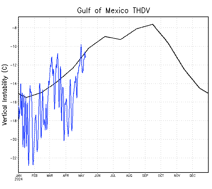
Is a big if at this time that El Nino is up soon so any warm episode would be a Modoki one if Nino 1+2 doesn't go above +0.5C. (Well in Neutral on January 5) That would be good for North Atlantic Hurricane Season to be more active but other factors may cancel that like the Thermoline Circulation,,cooler sst's,Vertical Instability etc.
Visit the Caribbean-Central America Weather Thread where you can find at first post web cams,radars
and observations from Caribbean basin members
Click Here


 but again let's see how it goes as time goes by.


