Mediterranean TCRs

This is the general tropical discussion area. Anyone can take their shot at predicting a storms path.

Moderator: S2k Moderators

Forum rules

The posts in this forum are NOT official forecasts and should not be used as such. They are just the opinion of the poster and may or may not be backed by sound meteorological data. They are NOT endorsed by any professional institution or STORM2K. For official information, please refer to products from the National Hurricane Center and National Weather Service.

Help Support Storm2K
Message
Author
User avatar
Vince_and_Grace_fan
Category 1
Category 1
Posts: 315
Joined: Thu Nov 03, 2016 9:25 am
Location: Szombathely (Hungary)

Mediterranean TCRs

#1 Postby Vince_and_Grace_fan » Thu Mar 14, 2019 2:47 pm

Hi!
I made this topic to put here my TCRs to Mediterranean systems. :)

I finised Otilie's report, which is available here: http://zivipotty.hu/2018_otilie.pdf (or from here if that link don't work: http://zivipotty.hu/tcr.html )
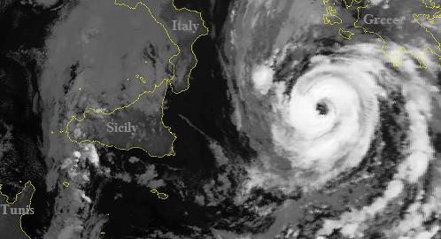
This was the firs cyclone last year that formed over the Tyrrhenian Sea.

Reports from Zorbas and Numa (2017) also will be coming within some weeks.
11 likes   

djones65
Category 1
Category 1
Posts: 264
Age: 58
Joined: Mon Jun 20, 2005 12:05 am
Location: Ocean Springs, MS

Re: Mediterranean TCRs

#2 Postby djones65 » Thu Mar 14, 2019 10:54 pm

Very, very nice V&G fan!!!
You did a fantastic job! And I appreciated the graphics.
I look forward to your future reports.
Well done!
3 likes   

GSBHurricane
Tropical Storm
Tropical Storm
Posts: 157
Joined: Mon Sep 17, 2018 10:12 am

Re: Mediterranean TCRs

#3 Postby GSBHurricane » Mon Mar 18, 2019 10:20 pm

One word. Wow. Just wow.
2 likes   

User avatar
Vince_and_Grace_fan
Category 1
Category 1
Posts: 315
Joined: Thu Nov 03, 2016 9:25 am
Location: Szombathely (Hungary)

Re: Mediterranean TCRs

#4 Postby Vince_and_Grace_fan » Fri Mar 29, 2019 8:29 am

Report from TS Zorbas is done: http://zivipotty.hu/2018_zorbas.pdf (or from here: http://zivipotty.hu/tcr.html )
5 likes   

djones65
Category 1
Category 1
Posts: 264
Age: 58
Joined: Mon Jun 20, 2005 12:05 am
Location: Ocean Springs, MS

Re: Mediterranean TCRs

#5 Postby djones65 » Fri Mar 29, 2019 10:07 pm

Excellent report once again!
However, based on the surface reports you provided along with the satellite imagery... I can make a case that Zorbas may have actually been a hurricane just as it made landfall.
1 likes   

User avatar
Vince_and_Grace_fan
Category 1
Category 1
Posts: 315
Joined: Thu Nov 03, 2016 9:25 am
Location: Szombathely (Hungary)

Re: Mediterranean TCRs - Ianos report is done

#6 Postby Vince_and_Grace_fan » Tue Dec 22, 2020 1:14 pm

I finished Ianos's report: http://zivipotty.hu/2020_ianos.pdf (or from here if the link not working: http://zivipotty.hu/tcr.html)
I put the peak intensity to 75 kt which is maybe a bit conservative, but based on the 984 hPa pressure data at the landfall I think that the 85 kt 1-min wind overrepresented the real intensity. I saw on Twitter that a Greek report will come out in the next weeks/mounths which included more data, I am waiting it excited.

And based on Ianos, I now think more possible that Zorbas in 2018 also briefly reached the hurricane intensity. The ASCAT measured 50 kt maximum wind a few hours before the landfall like in this case.
11 likes   

User avatar
DanieleItalyRm
Category 1
Category 1
Posts: 486
Age: 38
Joined: Mon Sep 22, 2008 7:52 am
Location: Rome - Italy - Mediterranean sea

Re: Mediterranean TCRs

#7 Postby DanieleItalyRm » Fri Jan 08, 2021 7:07 pm

I really admire your analysies on the Mediterranean cyclones Herincs David. Especially the tables with the various phases and intensity peaks. I wonder if you will do a similar job with 03M Andira (Elaina) on the eastern Mediterranean on this past December.
Daniele
3 likes   

User avatar
Vince_and_Grace_fan
Category 1
Category 1
Posts: 315
Joined: Thu Nov 03, 2016 9:25 am
Location: Szombathely (Hungary)

Re: Mediterranean TCRs

#8 Postby Vince_and_Grace_fan » Mon Jan 11, 2021 5:28 am

DanieleItalyRm wrote:I really admire your analysies on the Mediterranean cyclones Herincs David. Especially the tables with the various phases and intensity peaks. I wonder if you will do a similar job with 03M Andira (Elaina) on the eastern Mediterranean on this past December.
Daniele


Thanks! :)
I will have a bit harder work with Andira because much less data was available associated with it than with Ianos, but I try to do an acceptable estimation.

But I'm currently working on Detlef's (2019) report, I will likely finish it in a week.
2 likes   

User avatar
DanieleItalyRm
Category 1
Category 1
Posts: 486
Age: 38
Joined: Mon Sep 22, 2008 7:52 am
Location: Rome - Italy - Mediterranean sea

Re: Mediterranean TCRs

#9 Postby DanieleItalyRm » Fri Jan 15, 2021 7:56 am

Vince_and_Grace_fan wrote:
DanieleItalyRm wrote:I really admire your analysies on the Mediterranean cyclones Herincs David. Especially the tables with the various phases and intensity peaks. I wonder if you will do a similar job with 03M Andira (Elaina) on the eastern Mediterranean on this past December.
Daniele


Thanks! :)
I will have a bit harder work with Andira because much less data was available associated with it than with Ianos, but I try to do an acceptable estimation.

But I'm currently working on Detlef's (2019) report, I will likely finish it in a week.


In the Future it would be fantastic of you a similar work for the main Mediterranean TC of the past (even if I understand you will find much less data) or at least a consistent track with the various phases and base on Dvoark technique:

CLICK on Vis to loop Sat:

Oct.1996
http://meteorologia.uib.eu/medicanes/me ... icane.html

Jan.1995
http://meteorologia.uib.eu/medicanes/me ... icane.html

Dec.1985
http://meteorologia.uib.eu/medicanes/me ... icane.html

Sept.1983
http://meteorologia.uib.eu/medicanes/me ... icane.html

Jan.1982
Image
5 likes   

User avatar
Vince_and_Grace_fan
Category 1
Category 1
Posts: 315
Joined: Thu Nov 03, 2016 9:25 am
Location: Szombathely (Hungary)

Re: Mediterranean TCRs - Detlef report is done

#10 Postby Vince_and_Grace_fan » Thu Jan 21, 2021 4:59 pm

It lasted a few days longer, but here is the report from Detlef: http://zivipotty.hu/2019_detlef.pdf (or from here: http://zivipotty.hu/tcr.html)
According to the upper level environment, it remained rather subtropical despite the well-defined structure just before the landfall.
3 likes   

User avatar
DanieleItalyRm
Category 1
Category 1
Posts: 486
Age: 38
Joined: Mon Sep 22, 2008 7:52 am
Location: Rome - Italy - Mediterranean sea

Re: Mediterranean TCRs - Detlef report is done

#11 Postby DanieleItalyRm » Tue Jan 26, 2021 4:14 am

Vince_and_Grace_fan wrote:It lasted a few days longer, but here is the report from Detlef: http://zivipotty.hu/2019_detlef.pdf (or from here: http://zivipotty.hu/tcr.html)
According to the upper level environment, it remained rather subtropical despite the well-defined structure just before the landfall.

Good Job Hérincs. I Agree with you. In the end I also concluded that Detlef has not completed a tropical transition (also because it was too close to landfall). The system was still a little connected to the front and to the infrared the convective bands around the eye were more "ironed" than those of a real CDO. For this reasons Detlef it is more suitable as a Subtropical. Similarly like Qendresa, although Qendresa had perhaps for a few hours attained a tropical status close to eastern Sicily.
I hope you also have in mind the cyclone Numa from November 2017. I am sure that Numa was completely Tropical during the night between November 17th and 18th.
1 likes   

User avatar
Vince_and_Grace_fan
Category 1
Category 1
Posts: 315
Joined: Thu Nov 03, 2016 9:25 am
Location: Szombathely (Hungary)

Re: Mediterranean TCRs

#12 Postby Vince_and_Grace_fan » Mon Aug 30, 2021 1:53 pm

After 2 years, Numa is finally done. :D
http://zivipotty.hu/2017_numa.pdf (or from here, if the lint doesn't work: http://zivipotty.hu/tcr.html)
10 likes   

User avatar
DanieleItalyRm
Category 1
Category 1
Posts: 486
Age: 38
Joined: Mon Sep 22, 2008 7:52 am
Location: Rome - Italy - Mediterranean sea

Re: Mediterranean TCRs

#13 Postby DanieleItalyRm » Sat Sep 04, 2021 12:55 am

Thanks.
Your approach to Mediterranean cyclones is the only coherent one in existence, with extremely detailed data.
I am curious to see the detail of 03M on the eastern Mediterranean, I believe it was similar to Numa in intensity.
Daniele
5 likes   

User avatar
Vince_and_Grace_fan
Category 1
Category 1
Posts: 315
Joined: Thu Nov 03, 2016 9:25 am
Location: Szombathely (Hungary)

Re: Mediterranean TCRs

#14 Postby Vince_and_Grace_fan » Mon Sep 06, 2021 7:22 am

DanieleItalyRm wrote:Thanks.
Your approach to Mediterranean cyclones is the only coherent one in existence, with extremely detailed data.
I am curious to see the detail of 03M on the eastern Mediterranean, I believe it was similar to Numa in intensity.
Daniele


Thanks Daniele!

03M/Andira will be the next report, I've already started to work on them. I put the peak intensity to 55 kt, but based on the satellite and radar appearance it could be a little stronger. Unfortunately I didn't found direct land or ship measurements from its tropical phase near the center.
3 likes   

User avatar
Vince_and_Grace_fan
Category 1
Category 1
Posts: 315
Joined: Thu Nov 03, 2016 9:25 am
Location: Szombathely (Hungary)

Re: Mediterranean TCRs

#15 Postby Vince_and_Grace_fan » Tue Oct 19, 2021 2:20 pm

Andira's report is done. :)
http://zivipotty.hu/2020_andira.pdf (or from here: http://zivipotty.hu/tcr.html)
8 likes   

User avatar
MHC Tracking
Tropical Storm
Tropical Storm
Posts: 166
Joined: Mon Mar 15, 2021 10:05 am

Re: Mediterranean TCRs

#16 Postby MHC Tracking » Tue Oct 19, 2021 3:38 pm

Nice job
1 likes   

User avatar
AJC3
Admin
Admin
Posts: 3865
Age: 60
Joined: Tue Aug 31, 2004 7:04 pm
Location: West Melbourne, Florida
Contact:

Re: Mediterranean TCRs

#17 Postby AJC3 » Tue Oct 19, 2021 3:44 pm

Vince_and_Grace_fan wrote:Andira's report is done. :)
http://zivipotty.hu/2020_andira.pdf (or from here: http://zivipotty.hu/tcr.html)


Another EXCELLENT write-up as usual, Dávid. Well worth the read!
4 likes   

User avatar
DanieleItalyRm
Category 1
Category 1
Posts: 486
Age: 38
Joined: Mon Sep 22, 2008 7:52 am
Location: Rome - Italy - Mediterranean sea

Re: Mediterranean TCRs

#18 Postby DanieleItalyRm » Mon Oct 25, 2021 4:12 am

So far we have 6 ratings from agencies.
Short experimental passages SAB-NOAA:
01M-2011 (Rolf)
90M-2016 (Trixie)

Met Office:
01M-2018 (Zorbas)
01M-2020 (Ianos)
02M-2020 (Masinissa)
03M-2020 (Andira)

Can you confirm it Dàvid?

Image
0 likes   

User avatar
Vince_and_Grace_fan
Category 1
Category 1
Posts: 315
Joined: Thu Nov 03, 2016 9:25 am
Location: Szombathely (Hungary)

Re: Mediterranean TCRs

#19 Postby Vince_and_Grace_fan » Mon Oct 25, 2021 9:07 am

DanieleItalyRm wrote:So far we have 6 ratings from agencies.
Short experimental passages SAB-NOAA:
01M-2011 (Rolf)
90M-2016 (Trixie)

Met Office:
01M-2018 (Zorbas)
01M-2020 (Ianos)
02M-2020 (Masinissa)
03M-2020 (Andira)

Can you confirm it Dàvid?


Yes, and the Met Office also classified the weak (sub)tropical cyclone (Scott) near Egypt in 2019. https://www.metoffice.gov.uk/data/tropicalcyclone/tracks/nhem19/01m.gif
In addition, Ianos was classified by the CIMSS too (http://tropic.ssec.wisc.edu/real-time/atms/archive/2020/202001M.html) and in this summary also referred to the cyclone as a hurricane: https://downloads.usda.library.cornell.edu/usda-esmis/files/cj82k728n/r781x571v/7h14bc86h/wwcb3820.pdf?fbclid=IwAR26GaCLNdOcq6Q-usZ7MLZF4n1DLZ-v5MW5mPYmiP0ugMtMyj51jADaAdA#page=27
2 likes   

User avatar
Vince_and_Grace_fan
Category 1
Category 1
Posts: 315
Joined: Thu Nov 03, 2016 9:25 am
Location: Szombathely (Hungary)

Re: Mediterranean TCRs

#20 Postby Vince_and_Grace_fan » Thu Mar 03, 2022 5:12 pm

I finished Masinissa's report: http://zivipotty.hu/2020_masinissa.pdf (or from here: http://zivipotty.hu/tcr.html )

Although it looked quite tropical before the landfall, according to the reanalysis it remained strongly connected with the upper level trough (and widespread, strong potential vorticity anomaly) over it, in addition satellite images and wind measurements also suggested some connection with the remaining frontal areas around the small core too. So based on these I left it as subtropical in its entire lifetime.
10 likes   


Return to “Talkin' Tropics”

Who is online

Users browsing this forum: Google Adsense [Bot], KirbyDude25 and 36 guests