Storms you believe were stronger than officially stated?

This is the general tropical discussion area. Anyone can take their shot at predicting a storms path.

Moderator: S2k Moderators

Forum rules

The posts in this forum are NOT official forecasts and should not be used as such. They are just the opinion of the poster and may or may not be backed by sound meteorological data. They are NOT endorsed by any professional institution or STORM2K. For official information, please refer to products from the National Hurricane Center and National Weather Service.

Help Support Storm2K
Message
Author
User avatar
Hammy
Category 5
Category 5
Posts: 5594
Age: 40
Joined: Fri May 25, 2012 5:25 pm
Contact:

Re: Storms you believe were stronger than officially stated?

#41 Postby Hammy » Sat Sep 18, 2021 8:49 pm

LARanger wrote:
I was composing a lengthy reply to Hammy's now-also-removed response, in which Hammy indicated that there was no evidence for a Cat4 landfall and proposed arguments against what's been referred to as a Cat5-level surge as being indicative of the wind strength. I fully agree that the surge is not relevant (excepting that it destroyed evidence for wind speeds), nor would it constitute part of my argument for Katrina as a 4 at landfall.

...

I would argue that without much firmer evidence that effectively rules out the original Cat4 designation, then the "ruling on the field" should stand. I further find it peculiar to assert that Katrina lost thirty miles per hour in a mere fifty miles inland but then only lost twenty miles per hour for the next 100 miles, especially given that higher wind speeds were felt inland at my location than would have been supported by the official speed as the eye passed. I mean, was she somehow a super-coupler of wind to surface?

...

Edit: For a similar case, see this cat's argument for a Cat4 (or less!) Camille from 2012 and compare that to the 2016 reanalysis that, even with the questionable speed cut from 190 to 175, still has her at 175mph.


Regarding the comparison with Camille, the reasoning of it being a Cat 4 never made any sense and wasn't really based on anything concrete.

A big reason for the weakening was ingesting continental air--I've seen quite a few posts over the years that talk about that preventing the air from mixing to the surface which likely contributed to the degree of weakening, as well as the wind field expanding (flatter pressure gradient) and if I recall (I could be wrong) being in a lower pressure environment in general. NHC notes that the structural changes were unusual and the flight level reduction would likely have over-estimated the intensity .

These data reveal an unusual,
broad, and elevated wind maximum in the 2-4 km layer (centered near the 700 mb flight level),
well above the more typical location of the maximum wind near the top of the boundary layer
(~500 m) that had been observed on 28 August.


That said, it is not out of the realm of possibility of a Cat 4 coastal impact, even if the winds had weakened by the time of actual landfall:

It is worth noting that Katrina was likely at
Category 4 strength with maximum sustained winds of about 115 kt near 0900 UTC 29 August, a
couple of hours before the center made landfall near Buras, LA. Due to the large (~25-30 n mi)
radius of maximum winds, it is possible that sustained winds of Category 4 strength briefly
impacted the extreme southeastern tip of Louisiana in advance of landfall of the center.


From the NHC post-storm report: https://www.nhc.noaa.gov/data/tcr/AL122005_Katrina.pdf
0 likes   
The above post is not official and should not be used as such. It is the opinion of the poster and may or may not be backed by sound meteorological data. It is not endorsed by any professional institution or storm2k.org. For official information, please refer to the NHC and NWS products.

User avatar
AnnularCane
S2K Supporter
S2K Supporter
Posts: 2619
Joined: Thu Jun 08, 2006 9:18 am
Location: Wytheville, VA

Re: Storms you believe were stronger than officially stated?

#42 Postby AnnularCane » Mon Sep 20, 2021 5:00 pm

It might be premature, but I'm getting halfway tempted to add Rose to this list.
5 likes   
"But it never rained rain. It never snowed snow. And it never blew just wind. It rained things like soup and juice. It snowed mashed potatoes and green peas. And sometimes the wind blew in storms of hamburgers." -- Judi Barrett, Cloudy with a Chance of Meatballs

User avatar
Hammy
Category 5
Category 5
Posts: 5594
Age: 40
Joined: Fri May 25, 2012 5:25 pm
Contact:

Re: Storms you believe were stronger than officially stated?

#43 Postby Hammy » Tue Sep 21, 2021 2:53 am

Continuing to go through past seasons

Danielle (1986) could have been as high as 65-70, as mircraft measured winds “approaching hurricane force just north of the center” as noted in the post analysis, and there have been several storms since that were sheared storms with higher pressure but still came close to hurricane force due to the forward speed and pressure gradient.

TD14 (1987) widespread reports of 40-45 mph sustained winds in the Keys as the center passed to the southwest on November 3 supports this being a tropical storm.

Keith (1988) was likely a hurricane based on the official intensity of 70 mph being based on land observations to the west of the center as it accelerated northward, while no recon was active, so more than likely the winds to the east were stronger.

I feel Helene might have also been stronger as well but there is no data to back that up, as the 145 mph intensity was based purely on satellite estimates.

Iris (1989) was probably a hurricane given the VDM and recon data on Sep 19 had 75 mph surface winds with 83 mph flight winds.

Karen (1989) was similarly likely a tad stronger, as a Nov 30 VDM reported 65kt flight winds with 55 kt surface (official intensity was 60)

Arthur (1990) the most compelling case for a hurricane upgrade. VDM on 25/1725z noted 87kt flight winds with 65-70kt surface winds, 995mb pressure, and a circular 9mi diameter eye, and a second one on 25/2345z still noted 68kt flight winds with 998mb pressure

Grace (1991) may have been stronger than the 90kt official intensity given 111kt flight winds and 'near 100kt' surface winds on the 29th as it accelerated.
5 likes   
The above post is not official and should not be used as such. It is the opinion of the poster and may or may not be backed by sound meteorological data. It is not endorsed by any professional institution or storm2k.org. For official information, please refer to the NHC and NWS products.

Sciencerocks
Category 5
Category 5
Posts: 7266
Age: 38
Joined: Thu Jul 06, 2017 1:51 am

Re: Storms you believe were stronger than officially stated?

#44 Postby Sciencerocks » Sat Sep 25, 2021 1:48 am

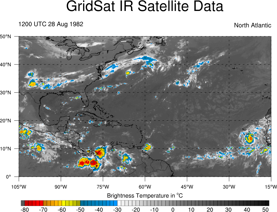
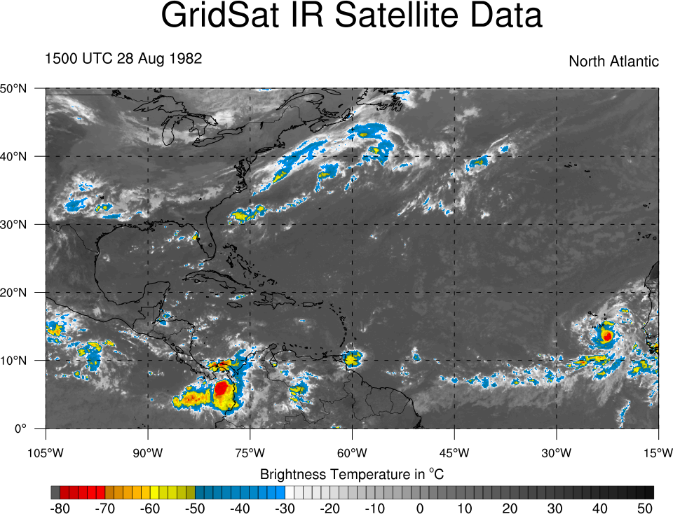
Beryl of 1982! It had a clearly defined pinhole eye. The nhc rated it at 70 mph at that time. lol

Looked like a cat2
Image
Image
3 likes   

User avatar
Teban54
Category 5
Category 5
Posts: 1903
Joined: Sat May 19, 2018 1:19 pm

Re: Storms you believe were stronger than officially stated?

#45 Postby Teban54 » Sun Sep 26, 2021 10:26 am

Sam.
6 likes   

Foxfires
Tropical Storm
Tropical Storm
Posts: 146
Joined: Fri Dec 03, 2021 11:50 pm

Re: Storms you believe were stronger than officially stated?

#46 Postby Foxfires » Thu Sep 29, 2022 8:39 am

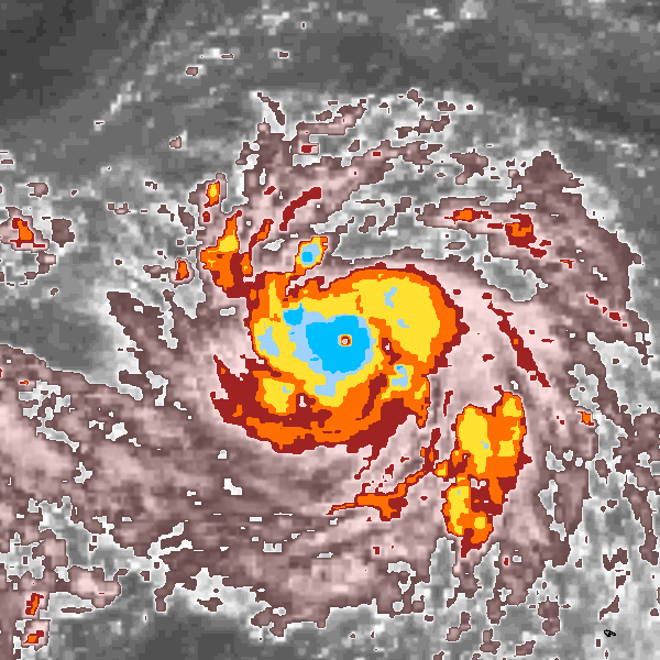
Image

This is Severe Tropical Storm/Typhoon Nock-Ten 2011.

JMA estimated 45kt (10-min) at the time of this image.

So either I'm crazy or chances are, this was not 45kt.

Feel free to slap me if I'm crazy.
3 likes   

User avatar
Hurricane2022
Category 3
Category 3
Posts: 876
Joined: Tue Aug 23, 2022 11:38 pm
Location: Araçatuba, Brazil

Re: Storms you believe were stronger than officially stated?

#47 Postby Hurricane2022 » Thu Sep 29, 2022 9:19 am

I think Nanmadol recently is likely much stronger than estimated by JTWC.

In Nanmadol recon from Japan reported 911 hPa, during the time when it was likely weakening.
 https://twitter.com/CyanideCN_/status/1571615348528680960


So, I can say that Nanmadol likely peaked with sub-910 mbar overnight (about 905 mbar) and winds near 145 kt (at least).
JTWC estimate of 135 kt was likely a mess
4 likes   
For reliable and detailed information for any meteorological phenomenon, please consult the National Hurricane Center, Joint Typhoon Warning Center , or your local Meteo Center.
Sorry for the bad English sometimes!!!

User avatar
Iceresistance
Category 5
Category 5
Posts: 8887
Age: 20
Joined: Sat Oct 10, 2020 9:45 am
Location: Tecumseh, OK/Norman, OK

Re: Storms you believe were stronger than officially stated?

#48 Postby Iceresistance » Thu Sep 29, 2022 9:25 am

Ian at Cuba and before the Florida landfall.
4 likes   
Bill 2015 & Beta 2020

Winter 2020-2021 :cold:

All observations are in Tecumseh, OK unless otherwise noted.

Winter posts are focused mainly for Oklahoma & Texas.

Take any of my forecasts with a grain of salt, refer to the NWS, SPC, and NHC for official information

Never say Never with weather! Because ANYTHING is possible!

User avatar
weeniepatrol
Category 3
Category 3
Posts: 847
Joined: Sat Aug 22, 2020 5:30 pm
Location: WA State

Re: Storms you believe were stronger than officially stated?

#49 Postby weeniepatrol » Thu Sep 29, 2022 9:36 am

Foxfires wrote:https://ibtracs.unca.edu/hursat/2011/2011205N12130.NOCK-TEN.2011.07.27.0000.28.FY2-E.052.hursat-b1.v07.png

This is Severe Tropical Storm/Typhoon Nock-Ten 2011.

JMA estimated 45kt (10-min) at the time of this image.

So either I'm crazy or chances are, this was not 45kt.

Feel free to slap me if I'm crazy.


Dont worry. JMA is crazy not you
0 likes   

User avatar
WiscoWx02
Category 1
Category 1
Posts: 340
Age: 21
Joined: Sat Jul 31, 2021 8:09 pm
Location: Minnesota

Re: Storms you believe were stronger than officially stated?

#50 Postby WiscoWx02 » Thu Sep 29, 2022 12:36 pm

Teban54 wrote:Sam.


I agree 100%. Sam was a category 5 in my opinion even if it wasn’t for a long time…possibly 3 times. But without consistent recon data we will never know for sure.
5 likes   

User avatar
Hammy
Category 5
Category 5
Posts: 5594
Age: 40
Joined: Fri May 25, 2012 5:25 pm
Contact:

Re: Storms you believe were stronger than officially stated?

#51 Postby Hammy » Thu Sep 29, 2022 5:35 pm

I'm tossing TD11 on the pile, given the ASCAT's low bias it was probably a tropical storm the night before advisories were initiated.

Sciencerocks wrote:Beryl of 1982! It had a clearly defined pinhole eye. The nhc rated it at 70 mph at that time. lol

Looked like a cat2
http://www.atmos.albany.edu/student/ppapin/maps/gridsat/1982/atl/ir_sat_atl_8_220.png
http://www.atmos.albany.edu/student/ppapin/maps/gridsat/1982/atl/ir_sat_atl_8_221.png


It's worse than that, it was only rated 45-50 mph at that time.
3 likes   
The above post is not official and should not be used as such. It is the opinion of the poster and may or may not be backed by sound meteorological data. It is not endorsed by any professional institution or storm2k.org. For official information, please refer to the NHC and NWS products.

User avatar
Hurricaneman
Category 5
Category 5
Posts: 7279
Age: 43
Joined: Tue Aug 31, 2004 3:24 pm
Location: central florida

Re: Storms you believe were stronger than officially stated?

#52 Postby Hurricaneman » Thu Sep 29, 2022 7:28 pm

1971
TD8 op35mph to 65mph
Ginger op110mph to 120mph
Kristy op50mph to 65mph

1973
Gilda op70mph to 80mph

1974
TD1 op30mph to 60mph

1975
Amy Op70mph to 80mph

1981
TD2 op35mph to 45mph
TD8 op35mph to 40mph
Emily op90mph to 105mph
TD13 op35mph to 45mph

1982
Beryl op70mph to 100mph

1984
TD3 op35mph to 45mph
Diana op130mph to 145mph

1985
Gloria op145mph to 165mph
Kate op120mph to 130mph
TD13 op 35mph to 40mph

1986
TD6 op35mph to 40mph

1988
Alberto op40mph to 50mph
TD10 op35mph to 40mph
Keith op70mph to 80mph
0 likes   

Foxfires
Tropical Storm
Tropical Storm
Posts: 146
Joined: Fri Dec 03, 2021 11:50 pm

Re: Storms you believe were stronger than officially stated?

#53 Postby Foxfires » Thu Sep 29, 2022 8:12 pm

Hurricane2022 wrote:I think Nanmadol recently is likely much stronger than estimated by JTWC.

In Nanmadol recon from Japan reported 911 hPa, during the time when it was likely weakening.
https://twitter.com/CyanideCN_/status/1571615348528680960
So, I can say that Nanmadol likely peaked with sub-910 mbar overnight (about 905 mbar) and winds near 145 kt (at least).
JTWC estimate of 135 kt was likely a mess


I assume they were going off of the extrapolated pressure of 918mb, which is why Nanmadol's peak is set at 916mb. Perhaps they did not notice the 911mb reading or did not find it reliable. If they don't upgrade it post analysis I'd like to see their reasoning on that.

Also did it weaken enough by then to have possibly peaked at 905mb? JTWC estimates would indicate a slow weakening near peak intensity but perhaps the estimates of Storm2k users differ.
1 likes   

Foxfires
Tropical Storm
Tropical Storm
Posts: 146
Joined: Fri Dec 03, 2021 11:50 pm

Re: Storms you believe were stronger than officially stated?

#54 Postby Foxfires » Fri Feb 03, 2023 12:29 am

Image

At the time of this image (which is not the storm's official peak)
JMA, CMA, & HKO: 985mb

I'm sorry, what? I must be stupid.
0 likes   

User avatar
ElectricStorm
Category 5
Category 5
Posts: 4493
Age: 23
Joined: Tue Aug 13, 2019 11:23 pm
Location: Skiatook, OK / Norman, OK

Re: Storms you believe were stronger than officially stated?

#55 Postby ElectricStorm » Fri Feb 03, 2023 1:42 am

Foxfires wrote:https://ncics.org/ibtracs/hursat/1996/1996261N08184.YATES.1996.09.23.1200.26.GMS-5.061.hursat-b1.v07.png

At the time of this image (which is not the storm's official peak)
JMA, CMA, & HKO: 985mb

I'm sorry, what? I must be stupid.

What storm is that?
0 likes   
I am in no way a professional. Take what I say with a grain of salt as I could be totally wrong. Please refer to the NHC, NWS, or SPC for official information.

Boomer Sooner!

Foxfires
Tropical Storm
Tropical Storm
Posts: 146
Joined: Fri Dec 03, 2021 11:50 pm

Re: Storms you believe were stronger than officially stated?

#56 Postby Foxfires » Fri Feb 03, 2023 5:32 am

ElectricStorm wrote:
Foxfires wrote:https://ncics.org/ibtracs/hursat/1996/1996261N08184.YATES.1996.09.23.1200.26.GMS-5.061.hursat-b1.v07.png

At the time of this image (which is not the storm's official peak)
JMA, CMA, & HKO: 985mb

I'm sorry, what? I must be stupid.

What storm is that?


Typhoon Yates 1996 at 09/23/12Z
Data from https://ncics.org/ibtracs/index.php?name=v04r00-1996261N08184
0 likes   

CrazyC83
Professional-Met
Professional-Met
Posts: 33391
Joined: Tue Mar 07, 2006 11:57 pm
Location: Deep South, for the first time!

Re: Storms you believe were stronger than officially stated?

#57 Postby CrazyC83 » Thu Feb 09, 2023 3:18 pm

Foxfires wrote:
ElectricStorm wrote:
Foxfires wrote:https://ncics.org/ibtracs/hursat/1996/1996261N08184.YATES.1996.09.23.1200.26.GMS-5.061.hursat-b1.v07.png

At the time of this image (which is not the storm's official peak)
JMA, CMA, & HKO: 985mb

I'm sorry, what? I must be stupid.

What storm is that?


Typhoon Yates 1996 at 09/23/12Z
Data from https://ncics.org/ibtracs/index.php?name=v04r00-1996261N08184


I'd put that at 125 kt - looks to be T6.5 to me.
0 likes   

User avatar
Iceresistance
Category 5
Category 5
Posts: 8887
Age: 20
Joined: Sat Oct 10, 2020 9:45 am
Location: Tecumseh, OK/Norman, OK

Re: Storms you believe were stronger than officially stated?

#58 Postby Iceresistance » Thu Feb 09, 2023 3:44 pm

CrazyC83 wrote:
Foxfires wrote:
ElectricStorm wrote:What storm is that?


Typhoon Yates 1996 at 09/23/12Z
Data from https://ncics.org/ibtracs/index.php?name=v04r00-1996261N08184


I'd put that at 125 kt - looks to be T6.5 to me.


JTWC is much more accurate with 130 knots (150 mph) and 918 mb with Yates.

The 1996 ACTR has STY Yates at pages 166-170
https://www.metoc.navy.mil/jtwc/products/atcr/1996atcr.pdf
0 likes   
Bill 2015 & Beta 2020

Winter 2020-2021 :cold:

All observations are in Tecumseh, OK unless otherwise noted.

Winter posts are focused mainly for Oklahoma & Texas.

Take any of my forecasts with a grain of salt, refer to the NWS, SPC, and NHC for official information

Never say Never with weather! Because ANYTHING is possible!

Foxfires
Tropical Storm
Tropical Storm
Posts: 146
Joined: Fri Dec 03, 2021 11:50 pm

Re: Storms you believe were stronger than officially stated?

#59 Postby Foxfires » Mon Feb 13, 2023 6:35 am

Iceresistance wrote:
CrazyC83 wrote:
Foxfires wrote:
Typhoon Yates 1996 at 09/23/12Z
Data from https://ncics.org/ibtracs/index.php?name=v04r00-1996261N08184


I'd put that at 125 kt - looks to be T6.5 to me.


JTWC is much more accurate with 130 knots (150 mph) and 918 mb with Yates.

The 1996 ACTR has STY Yates at pages 166-170
https://www.metoc.navy.mil/jtwc/products/atcr/1996atcr.pdf


I'm assuming CrazyC83 is talking about at the time of the image.

Just noting that the image is not marked as the storm's peak by any agency. The JTWC actually gave it 115kt at the time of the image. I don't have the confidence or expertise to try to assess whether or not its official peak looks more intense than the image.
0 likes   


Return to “Talkin' Tropics”

Who is online

Users browsing this forum: duilaslol and 35 guests