
Two things occurred to me, one is that if we do end up making it through August with nothing and then have a bust of activity in September, this may shed some light on what was going on in 1961 absent having found earlier articles on it, as the stronger than usual monsoon trough is the culprit this time.
The second is if that volcano on Tonga is having any impact on the WPAC being so inactive.
2022 Indicators (SSTs/SAL/MSLP/Shear/Steering/Instability) and >Day 16 Models
Moderator: S2k Moderators
Forum rules

The posts in this forum are NOT official forecasts and should not be used as such. They are just the opinion of the poster and may or may not be backed by sound meteorological data. They are NOT endorsed by any professional institution or STORM2K. For official information, please refer to products from the National Hurricane Center and National Weather Service.
Re: 2022 Indicators (SSTs/SAL/MSLP/Shear/Steering/Instability) and >Day 16 Models
0 likes
The above post is not official and should not be used as such. It is the opinion of the poster and may or may not be backed by sound meteorological data. It is not endorsed by any professional institution or storm2k.org. For official information, please refer to the NHC and NWS products.

Re: 2022 Indicators (SSTs/SAL/MSLP/Shear/Steering/Instability) and >Day 16 Models
Hammy wrote:Two things occurred to me, one is that if we do end up making it through August with nothing and then have a bust of activity in September, this may shed some light on what was going on in 1961 absent having found earlier articles on it, as the stronger than usual monsoon trough is the culprit this time.
The second is if that volcano on Tonga is having any impact on the WPAC being so inactive.
Last I saw, the amount of dust and aerosols released into the atmosphere was expected to have a 0.1-0.5C cooling effect only in the SHem until approximately September-November 2022. It’s possible this was enough to disrupt some global weather patterns and be one contributor to the tropical anomalies in the NHem. Or its occurrence ahead of such a weird NHem TC season was just a coincidence and it hasn’t had any significant impacts outside of the SHem.
4 likes
Irene '11 Sandy '12 Hermine '16 5/15/2018 Derecho Fay '20 Isaias '20 Elsa '21 Henri '21 Ida '21
I am only a meteorology enthusiast who knows a decent amount about tropical cyclones. Look to the professional mets, the NHC, or your local weather office for the best information.
I am only a meteorology enthusiast who knows a decent amount about tropical cyclones. Look to the professional mets, the NHC, or your local weather office for the best information.
-
NotSparta

- Professional-Met

- Posts: 1645
- Age: 22
- Joined: Fri Aug 18, 2017 8:24 am
- Location: Naples, FL
- Contact:
Re: 2022 Indicators (SSTs/SAL/MSLP/Shear/Steering/Instability) and >Day 16 Models
Blown Away wrote:cycloneye wrote:https://twitter.com/DylanFedericoWX/status/1558462470049726464
Now we are only half way in August, but the only year I could find since 2000 was 2013 that had as dry of an August in SFL as current August 2022. Not that SFL rainfall speaks for the basin’s activity, but it is indicative of dust and the lack of moist TW’s moving through.
All of S FL, or just SE FL?
0 likes
This post was probably an opinion of mine, and in no way is official. Please refer to http://www.hurricanes.gov for official tropical analysis and advisories.
My website, with lots of tropical wx graphics, including satellite and recon: http://cyclonicwx.com
My website, with lots of tropical wx graphics, including satellite and recon: http://cyclonicwx.com
-
NotSparta
- Professional-Met
- Posts: 1645
- Age: 22
- Joined: Fri Aug 18, 2017 8:24 am
- Location: Naples, FL
- Contact:
Re: 2022 Indicators (SSTs/SAL/MSLP/Shear/Steering/Instability) and >Day 16 Models
Hammy wrote:Two things occurred to me, one is that if we do end up making it through August with nothing and then have a bust of activity in September, this may shed some light on what was going on in 1961 absent having found earlier articles on it, as the stronger than usual monsoon trough is the culprit this time.
The second is if that volcano on Tonga is having any impact on the WPAC being so inactive.
I think the main reason the WPAC is so quiet is how strong the La Nina is. The monsoon trough is basically absent which takes away from its main genesis pathway, and there's a sprawling, persistent upper trough in the area. Most Ninas aren't this strong in August so usually the WPAC isn't as quiet as it has been
5 likes
This post was probably an opinion of mine, and in no way is official. Please refer to http://www.hurricanes.gov for official tropical analysis and advisories.
My website, with lots of tropical wx graphics, including satellite and recon: http://cyclonicwx.com
My website, with lots of tropical wx graphics, including satellite and recon: http://cyclonicwx.com
Re: 2022 Indicators (SSTs/SAL/MSLP/Shear/Steering/Instability) and >Day 16 Models
NotSparta wrote:Hammy wrote:Two things occurred to me, one is that if we do end up making it through August with nothing and then have a bust of activity in September, this may shed some light on what was going on in 1961 absent having found earlier articles on it, as the stronger than usual monsoon trough is the culprit this time.
The second is if that volcano on Tonga is having any impact on the WPAC being so inactive.
I think the main reason the WPAC is so quiet is how strong the La Nina is. The monsoon trough is basically absent which takes away from its main genesis pathway, and there's a sprawling, persistent upper trough in the area. Most Ninas aren't this strong in August so usually the WPAC isn't as quiet as it has been
If that's the case is that likely contributing to the monsoon trough over Africa being where it's at?
0 likes
The above post is not official and should not be used as such. It is the opinion of the poster and may or may not be backed by sound meteorological data. It is not endorsed by any professional institution or storm2k.org. For official information, please refer to the NHC and NWS products.
-
toad strangler

- S2K Supporter

- Posts: 4162
- Joined: Sun Jul 28, 2013 3:09 pm
- Location: Earth
- Contact:
Re: 2022 Indicators (SSTs/SAL/MSLP/Shear/Steering/Instability) and >Day 16 Models
Blown Away wrote:cycloneye wrote:https://twitter.com/DylanFedericoWX/status/1558462470049726464
Now we are only half way in August, but the only year I could find since 2000 was 2013 that had as dry of an August in SFL as current August 2022. Not that SFL rainfall speaks for the basin’s activity, but it is indicative of dust and the lack of moist TW’s moving through.
Not in agreement. The lions share of rainfall on the E Coast comes from wet season sea breeze t storms. This year there has been a dominant EC sea breeze resulting in a banner year for central and west coast locations. I don’t think it has anything to do with true tropical waves from the East. We aren’t even in FL go time yet.
4 likes
-
Iceresistance

- Category 5

- Posts: 8910
- Age: 20
- Joined: Sat Oct 10, 2020 9:45 am
- Location: Tecumseh, OK/Norman, OK
Re: 2022 Indicators (SSTs/SAL/MSLP/Shear/Steering/Instability) and >Day 16 Models
cycloneye wrote:https://twitter.com/DylanFedericoWX/status/1558462470049726464
He really has a good point here, we're actually closer to 2010 when there was little storm activity across the globe until the Atlantic basin exploded with activity in Late August through November.
1 likes
Bill 2015 & Beta 2020
Winter 2020-2021
All observations are in Tecumseh, OK unless otherwise noted.
Winter posts are focused mainly for Oklahoma & Texas.
Take any of my forecasts with a grain of salt, refer to the NWS, SPC, and NHC for official information
Never say Never with weather! Because ANYTHING is possible!
Winter 2020-2021
All observations are in Tecumseh, OK unless otherwise noted.
Winter posts are focused mainly for Oklahoma & Texas.
Take any of my forecasts with a grain of salt, refer to the NWS, SPC, and NHC for official information
Never say Never with weather! Because ANYTHING is possible!
Re: 2022 Indicators (SSTs/SAL/MSLP/Shear/Steering/Instability) and >Day 16 Models
- I'm still sticking with 120 for my ACE prediction that goes back to late July.
- I remain most concerned about the Gulf coast of FL for the highest risk this season per the eight 3rd year La Niña analogs since every one had significant to major impact there.
- No TC genesis forecasted by the 12Z UKMET anywhere in the basin through hour 144.
- 12Z model consensus says we'll never know for sure whether yesterday's 12Z consensus of a strong storm into NE would have gotten a name due to possibly being a STS because today's 12Z consensus has only a significantly weaker system now.
- If we were to go another week or so with both nothing new as well as nothing imminent on model consensus, my ACE forecast would by then have been reduced from 120.
1 likes
Personal Forecast Disclaimer:
The posts in this forum are NOT official forecasts and should not be used as such. They are just the opinion of the poster and may or may not be backed by sound meteorological data. They are NOT endorsed by any professional institution or storm2k.org. For official information, please refer to the NHC and NWS products.
The posts in this forum are NOT official forecasts and should not be used as such. They are just the opinion of the poster and may or may not be backed by sound meteorological data. They are NOT endorsed by any professional institution or storm2k.org. For official information, please refer to the NHC and NWS products.

Re: 2022 Indicators (SSTs/SAL/MSLP/Shear/Steering/Instability) and >Day 16 Models
toad strangler wrote:Blown Away wrote:cycloneye wrote:https://twitter.com/DylanFedericoWX/status/1558462470049726464
Now we are only half way in August, but the only year I could find since 2000 was 2013 that had as dry of an August in SFL as current August 2022. Not that SFL rainfall speaks for the basin’s activity, but it is indicative of dust and the lack of moist TW’s moving through.
Not in agreement. The lions share of rainfall on the E Coast comes from wet season sea breeze t storms. This year there has been a dominant EC sea breeze resulting in a banner year for central and west coast locations. I don’t think it has anything to do with true tropical waves from the East. We aren’t even in FL go time yet.
Agreed. The Orlando area rains have been plentiful enough. Even getting odd hour very late evening storms that should typically be E. Coast diurnal stuff but with convergence seemingly occuring a good deal further west of the coastline.
0 likes
Personal Forecast Disclaimer:
The posts in this forum are NOT official forecast and should not be used as such. They are just the opinion of the poster and may or may not be backed by sound meteorological data. They are NOT endorsed by any professional institution or storm2k.org. For official information, please refer to the NHC and NWS products.
The posts in this forum are NOT official forecast and should not be used as such. They are just the opinion of the poster and may or may not be backed by sound meteorological data. They are NOT endorsed by any professional institution or storm2k.org. For official information, please refer to the NHC and NWS products.
Re: 2022 Indicators (SSTs/SAL/MSLP/Shear/Steering/Instability) and >Day 16 Models
Hmmm, on that note.... i wonder if there's any data that might corroborate years with especially strong surface to mid level ridging that resulted in a fairly sharp precip gradient between immediate Florida E. Coast areas, as compared to well inland or W. Coast regions?
It may be quite a reach and an overly broad assumption but, might such a dominant surface to mid level set-up suggest TC tracks potentially driven further west and well into the GOM rather then recurves ahead of any E. Seaboard weakness or troughing during peak activity?
It may be quite a reach and an overly broad assumption but, might such a dominant surface to mid level set-up suggest TC tracks potentially driven further west and well into the GOM rather then recurves ahead of any E. Seaboard weakness or troughing during peak activity?
1 likes
Personal Forecast Disclaimer:
The posts in this forum are NOT official forecast and should not be used as such. They are just the opinion of the poster and may or may not be backed by sound meteorological data. They are NOT endorsed by any professional institution or storm2k.org. For official information, please refer to the NHC and NWS products.
The posts in this forum are NOT official forecast and should not be used as such. They are just the opinion of the poster and may or may not be backed by sound meteorological data. They are NOT endorsed by any professional institution or storm2k.org. For official information, please refer to the NHC and NWS products.

Re: 2022 Indicators (SSTs/SAL/MSLP/Shear/Steering/Instability) and >Day 16 Models
Meanwhile here in coastal SEFL it really is just drier. There can showers out west or over the Bahamas and absolutely nothing here. Such a strange pattern. That east breeze is very heavy
0 likes
Andrew (1992), Irene (1999), Frances (2004), Katrina (2005), Wilma (2005), Fay (2008), Irma (2017), Eta (2020), Ian (2022)
-
skyline385

- Category 5
- Posts: 2444
- Age: 33
- Joined: Wed Aug 26, 2020 11:15 pm
- Location: Palm Beach County FL
Re: 2022 Indicators (SSTs/SAL/MSLP/Shear/Steering/Instability) and >Day 16 Models
Nuno wrote:Meanwhile here in coastal SEFL it really is just drier. There can showers out west or over the Bahamas and absolutely nothing here. Such a strange pattern. That east breeze is very heavy
Coastal SFL has been incredibly dry so far

Sent from my iPhone using Tapatalk
0 likes

Re: 2022 Indicators (SSTs/SAL/MSLP/Shear/Steering/Instability) and >Day 16 Models
skyline385 wrote:Nuno wrote:Meanwhile here in coastal SEFL it really is just drier. There can showers out west or over the Bahamas and absolutely nothing here. Such a strange pattern. That east breeze is very heavy
Coastal SFL has been incredibly dry so far
https://uploads.tapatalk-cdn.com/20220815/a72e473b5312661b957bd47441765b30.jpg
Sent from my iPhone using Tapatalk
Florida is so dry, those counties are sticking the bird at us.
2 likes
Personal Forecast Disclaimer:
The posts in this forum are NOT official forecast and should not be used as such. They are just the opinion of the poster and may or may not be backed by sound meteorological data. They are NOT endorsed by any professional institution or storm2k.org. For official information, please refer to the NHC and NWS products.
The posts in this forum are NOT official forecast and should not be used as such. They are just the opinion of the poster and may or may not be backed by sound meteorological data. They are NOT endorsed by any professional institution or storm2k.org. For official information, please refer to the NHC and NWS products.
-
cycloneye

- Admin

- Posts: 139025
- Age: 67
- Joined: Thu Oct 10, 2002 10:54 am
- Location: San Juan, Puerto Rico
Re: 2022 Indicators (SSTs/SAL/MSLP/Shear/Steering/Instability) and >Day 16 Models
0 likes
Visit the Caribbean-Central America Weather Thread where you can find at first post web cams,radars
and observations from Caribbean basin members Click Here
and observations from Caribbean basin members Click Here
-
Blown Away

- S2K Supporter
- Posts: 9861
- Joined: Wed May 26, 2004 6:17 am
Re: 2022 Indicators (SSTs/SAL/MSLP/Shear/Steering/Instability) and >Day 16 Models
[  url=https://postimg.cc/vDzzT69y]
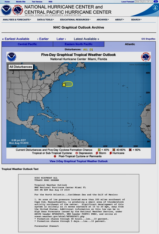 [/url]
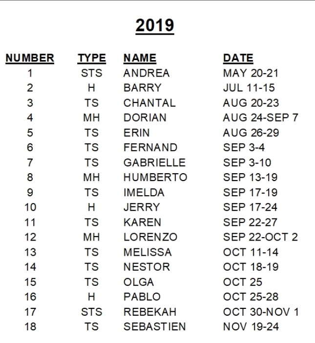
For example, August 19, 2019 Tropical Outlook and 3 systems formed within 6 days including monster Dorian.
IMO, in another week the Season Cancel posts will be on the shelf until August 2023!
[/url]For example, August 19, 2019 Tropical Outlook and 3 systems formed within 6 days including monster Dorian.
IMO, in another week the Season Cancel posts will be on the shelf until August 2023!
8 likes
Hurricane Eye Experience: David 79, Irene 99, Frances 04, Jeanne 04, Wilma 05...
Hurricane Brush Experience: Andrew 92, Erin 95, Floyd 99, Matthew 16, Irma 17, Ian 22, Nicole 22…
Hurricane Brush Experience: Andrew 92, Erin 95, Floyd 99, Matthew 16, Irma 17, Ian 22, Nicole 22…
-
AnnularCane

- S2K Supporter
- Posts: 2632
- Joined: Thu Jun 08, 2006 9:18 am
- Location: Wytheville, VA
Re: 2022 Indicators (SSTs/SAL/MSLP/Shear/Steering/Instability) and >Day 16 Models
Oh yes, 2019... The season cancel posts were rampant, as I recall. Then on bell-ringing day, right on cue, Chantal! And after Chantal...well, I don't think I need to tell anyone what happened then.
3 likes
"But it never rained rain. It never snowed snow. And it never blew just wind. It rained things like soup and juice. It snowed mashed potatoes and green peas. And sometimes the wind blew in storms of hamburgers." -- Judi Barrett, Cloudy with a Chance of Meatballs
-
cycloneye
- Admin
- Posts: 139025
- Age: 67
- Joined: Thu Oct 10, 2002 10:54 am
- Location: San Juan, Puerto Rico
Re: 2022 Indicators (SSTs/SAL/MSLP/Shear/Steering/Instability) and >Day 16 Models
About the different products to analize ssta data.
https://twitter.com/philklotzbach/status/1558999073385959424
https://twitter.com/philklotzbach/status/1558999073385959424
2 likes
Visit the Caribbean-Central America Weather Thread where you can find at first post web cams,radars
and observations from Caribbean basin members Click Here
and observations from Caribbean basin members Click Here
-
SconnieCane
- Category 4

- Posts: 913
- Joined: Thu Aug 02, 2018 5:29 pm
- Location: Madison, WI
Re: 2022 Indicators (SSTs/SAL/MSLP/Shear/Steering/Instability) and >Day 16 Models
I see in the other thread we've flipped directly from "The models show nothing, surely they must be right and we will have a 0/0/0 August" to "The models show something, surely they must be overdoing it."
I am serious...and stop calling me Shirley.
How many Airplane! references can I sneak into this thread, lol.
I am serious...and stop calling me Shirley.
How many Airplane! references can I sneak into this thread, lol.
13 likes
-
skyline385
- Category 5
- Posts: 2444
- Age: 33
- Joined: Wed Aug 26, 2020 11:15 pm
- Location: Palm Beach County FL
Re: 2022 Indicators (SSTs/SAL/MSLP/Shear/Steering/Instability) and >Day 16 Models
SconnieCane wrote:I see in the other thread we've flipped directly from "The models show nothing, surely they must be right and we will have a 0/0/0 August" to "The models show something, surely they must be overdoing it."
I am serious...and stop calling me Shirley.
How many Airplane! references can I sneak into this thread, lol.
Well 06Z GFS just went back to showing nothing because of the same reason I suggested why it might be overdoing the RI last run
0 likes
-
tolakram
- Admin
- Posts: 19165
- Age: 60
- Joined: Sun Aug 27, 2006 8:23 pm
- Location: Florence, KY (name is Mark)
Re: 2022 Indicators (SSTs/SAL/MSLP/Shear/Steering/Instability) and >Day 16 Models
Confirmation bias is strong, too strong for most amateurs, including me. What happens will happen, but generally throwing shade at the Euro is a long term losing bet.
0 likes
M a r k
- - - - -
Join us in chat: Storm2K Chatroom Invite. Android and IOS apps also available.
The posts in this forum are NOT official forecasts and should not be used as such. Posts are NOT endorsed by any professional institution or STORM2K.org. For official information and forecasts, please refer to NHC and NWS products.
Who is online
Users browsing this forum: NotSparta and 98 guests