The long-range models are showing the switch about to flip in the Atlantic Hurricane Season. Here's a new video update taking a look at things as well as the 1999 analog.
https://www.youtube.com/watch?v=5bWL1MYr0eo
2022 Indicators (SSTs/SAL/MSLP/Shear/Steering/Instability) and >Day 16 Models
Moderator: S2k Moderators
Forum rules

The posts in this forum are NOT official forecasts and should not be used as such. They are just the opinion of the poster and may or may not be backed by sound meteorological data. They are NOT endorsed by any professional institution or STORM2K. For official information, please refer to products from the National Hurricane Center and National Weather Service.
-
Hurricane Mike
- Category 2

- Posts: 562
- Joined: Tue Apr 10, 2018 7:44 am
Re: 2022 Indicators (SSTs/SAL/MSLP/Shear/Steering/Instability) and >Day 16 Models
I continue to have a concern about the AEW set to emerge within 24 hours. First, shear is low and is projected to remain low in much of the E and C MDR for a good # of days. In addition and somewhat related: steering by high pressure that builds westward to its north is progged to prevent an early safe recurve and thus would likely mean a move far west into the basin, a potentially very dangerous scenario IF dry air doesn't keep it weak as suggested by various ens members as well as a couple of GFS runs. It being La Nina and August (not as high a % of safe recurves of E MDR TCs for both categories) add to the concern.
Here's an updated satellite pic (IR) that shows similar to the prior pic that there may already be a weak circulation over far SW Mali despite convection having lightened up tonight:

Here's an updated satellite pic (IR) that shows similar to the prior pic that there may already be a weak circulation over far SW Mali despite convection having lightened up tonight:
3 likes
Personal Forecast Disclaimer:
The posts in this forum are NOT official forecasts and should not be used as such. They are just the opinion of the poster and may or may not be backed by sound meteorological data. They are NOT endorsed by any professional institution or storm2k.org. For official information, please refer to the NHC and NWS products.
The posts in this forum are NOT official forecasts and should not be used as such. They are just the opinion of the poster and may or may not be backed by sound meteorological data. They are NOT endorsed by any professional institution or storm2k.org. For official information, please refer to the NHC and NWS products.
-
weeniepatrol

- Category 3

- Posts: 857
- Joined: Sat Aug 22, 2020 5:30 pm
- Location: WA State
Re: 2022 Indicators (SSTs/SAL/MSLP/Shear/Steering/Instability) and >Day 16 Models
All aboard; the wave train is cleared for take off!


5 likes

Re: 2022 Indicators (SSTs/SAL/MSLP/Shear/Steering/Instability) and >Day 16 Models
Forget about a 2013 repeat those that keep bringing that year up. Which by the way, I looked back at the mid level humidity charts for that year, the MDR turned bone dry during the second half of August into September and October.
https://twitter.com/OSUWXGUY/status/1559830898509578242
https://twitter.com/OSUWXGUY/status/1559830898509578242
7 likes
-
Category5Kaiju

- Category 5

- Posts: 3357
- Age: 22
- Joined: Thu Dec 24, 2020 12:45 pm
- Location: Seattle
Re: 2022 Indicators (SSTs/SAL/MSLP/Shear/Steering/Instability) and >Day 16 Models
And just like that, it looks like the Atlantic has finally begun to show signs of waking up, with what seems to be some very aggressive recent runs on the GFS (in particular).
To put this into some perspective, I did not look at a single tropical weather-related thing during the past 3 days, and I gotta say, wow. 3 days. It merely took just 3 days for the general attitude to shift from "bust season," "too much wavebreaking," "dry MDR" (you get the idea)...to "oh wait, maybe the season isn't going to be a 2013 repeat or as dead as some are thinking..." Why is this the case? Well, it's simple. The models have finally begun to realize that the Atlantic is shaping up to be a favored part of the world for TC genesis, especially with all of the sinking motion over the Pacific (not to mention the absolute snoozefest of the Pacific basins now). Not to mention...yup, that's right...CLIMATOLOGY. Oh yeah, and also La Nina. For a season to be this quiet, activity is bound to erupt at some point. I mean, it's August, not October of 2021
As we have seen with the past many recent years since 2013, it's probably almost never (if ever) a good idea to bet that a given season is going to be that dead or that unexpectedly quiet. 2013 was basically 2005's polar opposite cousin, and in general, it's probably not an efficient plan to place a bet on a season performing as extreme as 2005 or 2013 ever did. I still have little idea on why there are those who immediately jump to extreme conclusions when judging a season, especially even before August 20. As tolakram mentioned in a storm discussion thread some years ago that I happened to read earlier this year out of curiosity, if you are going to cancel a season, do not hesitate to give some in-depth analyses on why you believe it to be destined for that kind of fate. Discussing a season is fun and productive, but merely shouting "bust" or "cancel" with no grounding or shaky evidence isn't as fun or productive.
Anyways, I certainly will be sporadically watching the tropics while monitoring my mental health and preparing to move into college soon. One thing that I love about weather tracking as a hobby is how volatile and thrilling it can be and how things (especially in the Atlantic) can change in a dime. And just like the past many years, it looks like 2022 is no exception in that regard. By November, I still firmly think that we're going to end up with a pretty above-average season, with the possibility of at least a couple major storms that will be talked about in subsequent seasons by us weather enthusiasts.
10 likes
Unless explicitly stated, all information covered in my posts is based on my opinions and observations. Please refer to a professional meteorologist or an accredited weather research agency otherwise, especially if serious decisions must be made in the event of a potentially life-threatening tropical storm or hurricane.
-
Iceresistance

- Category 5
- Posts: 8912
- Age: 20
- Joined: Sat Oct 10, 2020 9:45 am
- Location: Tecumseh, OK/Norman, OK
Re: 2022 Indicators (SSTs/SAL/MSLP/Shear/Steering/Instability) and >Day 16 Models
1 likes
Bill 2015 & Beta 2020
Winter 2020-2021
All observations are in Tecumseh, OK unless otherwise noted.
Winter posts are focused mainly for Oklahoma & Texas.
Take any of my forecasts with a grain of salt, refer to the NWS, SPC, and NHC for official information
Never say Never with weather! Because ANYTHING is possible!
Winter 2020-2021
All observations are in Tecumseh, OK unless otherwise noted.
Winter posts are focused mainly for Oklahoma & Texas.
Take any of my forecasts with a grain of salt, refer to the NWS, SPC, and NHC for official information
Never say Never with weather! Because ANYTHING is possible!
-
ScottNAtlanta

- Category 5
- Posts: 1998
- Joined: Sat May 25, 2013 3:11 pm
- Location: Atlanta, GA
Re: 2022 Indicators (SSTs/SAL/MSLP/Shear/Steering/Instability) and >Day 16 Models
I wish they could come up with a better way to plot the MJO...It is so hard for colorblind people to make any sense out of them
0 likes
The posts in this forum are NOT official forecast and should not be used as such. They are just the opinion of the poster and may or may not be backed by sound meteorological data. They are NOT endorsed by any professional institution or storm2k.org. For official information, please refer to the NHC and NWS products.
-
skyline385

- Category 5
- Posts: 2444
- Age: 33
- Joined: Wed Aug 26, 2020 11:15 pm
- Location: Palm Beach County FL
2022 Indicators (SSTs/SAL/MSLP/Shear/Steering/Instability) and >Day 16 Models
ScottNAtlanta wrote:
I wish they could come up with a better way to plot the MJO...It is so hard for colorblind people to make any sense out of them
Check out the one directly from ECMWF’s site, it is so much better visually although i am not sure how much it would help colorblind people.
https://apps.ecmwf.int/webapps/openchar ... 2208150000

Sent from my iPhone using Tapatalk
Last edited by skyline385 on Wed Aug 17, 2022 9:21 am, edited 1 time in total.
0 likes

Re: 2022 Indicators (SSTs/SAL/MSLP/Shear/Steering/Instability) and >Day 16 Models
Thanks Joe. Many of us have been saying this for a while. It’s just that the signal has been relatively weak. As of what is out today:
GEFS - crosses into Phase 1 on Friday
Japanese- Crosses into Phase 1 tomorrow but NCEP has yesterdays output still
EC - Crosses into 1 on Saturday
EC (bias corrected) - crosses into 1/2 on Sunday
Australian (bias corrected) - moves into 8 but NCEP still has Monday’s output. I’ll check later.
0 likes
-
Kingarabian

- S2K Supporter

- Posts: 15434
- Joined: Sat Aug 08, 2009 3:06 am
- Location: Honolulu, Hawaii
Re: 2022 Indicators (SSTs/SAL/MSLP/Shear/Steering/Instability) and >Day 16 Models
I think current uptick isn't entirely from the MJO -- at least through the next 10 days.
The forecast from the MJO to enter the favorable phases for Atlantic TCG won't go into effect until about the first week of September. So we're probably looking at a very active September as well.
The forecast from the MJO to enter the favorable phases for Atlantic TCG won't go into effect until about the first week of September. So we're probably looking at a very active September as well.
5 likes
RIP Kobe Bryant
Re: 2022 Indicators (SSTs/SAL/MSLP/Shear/Steering/Instability) and >Day 16 Models
Kingarabian wrote:I think current uptick isn't entirely from the MJO -- at least through the next 10 days.
The forecast from the MJO to enter the favorable phases for Atlantic TCG won't go into effect until about the first week of September. So we're probably looking at a very active September as well.
It's been mostly silent this year season so far. Maybe it's chicken/egg between amplification and the MJO, but that's usually when we get bursts. I just follow it and am not an expert by any remote stretch. What I think matters for September is what it does and how long it stays in 2 (or possibly 3). Because the signal has been relatively weak, I don't expect that it would go far out into 5/6/7 where it's got to come all the way back around say by the end of September or early October. I think if it stays down in 2-3 for a week or so, maybe it rolls into 4 and back into the circle before reemerging into 8, 1 or 2. If so, that would signal maybe a brief lull before another round of systems.
2 likes
Re: 2022 Indicators (SSTs/SAL/MSLP/Shear/Steering/Instability) and >Day 16 Models
New Japanese Model is in (still waiting on Australian). It goes into 1 later tonight or tomorrow morning and is still in 2 by the 27th. NCEP doesn't have an extended output for JMA if one exists. That's at least 10 days in a hyper phase with likely a few more if it ran out farther.
https://www.cpc.ncep.noaa.gov/products/ ... jman.shtml
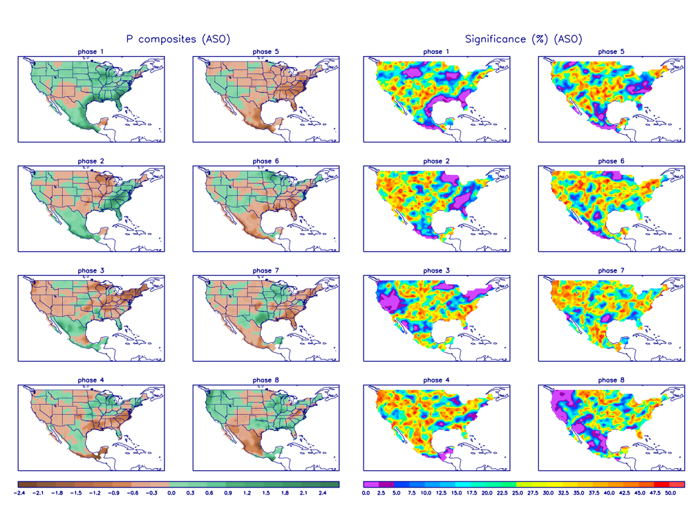
For reference: Here is the August/September/October precipitation distribution by Phase of the MJO.
https://www.cpc.ncep.noaa.gov/products/ ... _image.png
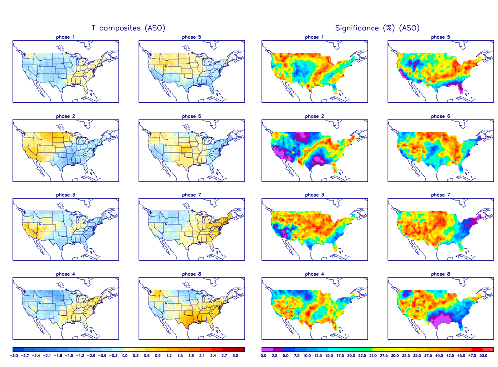
Here is the A/S/O temperature composite by Phase.
https://www.cpc.ncep.noaa.gov/products/ ... _image.png
https://www.cpc.ncep.noaa.gov/products/ ... jman.shtml
For reference: Here is the August/September/October precipitation distribution by Phase of the MJO.
https://www.cpc.ncep.noaa.gov/products/ ... _image.png
Here is the A/S/O temperature composite by Phase.
https://www.cpc.ncep.noaa.gov/products/ ... _image.png
2 likes
-
ScottNAtlanta
- Category 5
- Posts: 1998
- Joined: Sat May 25, 2013 3:11 pm
- Location: Atlanta, GA
Re: 2022 Indicators (SSTs/SAL/MSLP/Shear/Steering/Instability) and >Day 16 Models
skyline385 wrote:ScottNAtlanta wrote:
I wish they could come up with a better way to plot the MJO...It is so hard for colorblind people to make any sense out of them
Check out the one directly from ECMWF’s site, it is so much better visually although i am not sure how much it would help colorblind people.
https://apps.ecmwf.int/webapps/openchar ... 2208150000
https://uploads.tapatalk-cdn.com/20220817/65e326e53545337095eaa6c609f524e0.jpg
Sent from my iPhone using Tapatalk
I appreciate the effort, but from a colorblindness point of view that is infinitely worse
 I'm used to it by now
0 likes
The posts in this forum are NOT official forecast and should not be used as such. They are just the opinion of the poster and may or may not be backed by sound meteorological data. They are NOT endorsed by any professional institution or storm2k.org. For official information, please refer to the NHC and NWS products.

Re: 2022 Indicators (SSTs/SAL/MSLP/Shear/Steering/Instability) and >Day 16 Models
ScottNAtlanta wrote:skyline385 wrote:ScottNAtlanta wrote:I wish they could come up with a better way to plot the MJO...It is so hard for colorblind people to make any sense out of them
Check out the one directly from ECMWF’s site, it is so much better visually although i am not sure how much it would help colorblind people.
https://apps.ecmwf.int/webapps/openchar ... 2208150000
https://uploads.tapatalk-cdn.com/20220817/65e326e53545337095eaa6c609f524e0.jpg
Sent from my iPhone using Tapatalk
I appreciate the effort, but from a colorblindness point of view that is infinitely worse
May I suggest Enchroma color blind glasses? they really work.
0 likes
Robbielyn McCrary
I know just about enough to sound like I know what I'm talking about sometimes. But for your safety please follow the nhc for truly professional forecasting.
I know just about enough to sound like I know what I'm talking about sometimes. But for your safety please follow the nhc for truly professional forecasting.
-
USTropics
- Category 5
- Posts: 2410
- Joined: Sun Aug 12, 2007 3:45 am
- Location: Florida State University
Re: 2022 Indicators (SSTs/SAL/MSLP/Shear/Steering/Instability) and >Day 16 Models
ScottNAtlanta wrote:skyline385 wrote:ScottNAtlanta wrote:I wish they could come up with a better way to plot the MJO...It is so hard for colorblind people to make any sense out of them
Check out the one directly from ECMWF’s site, it is so much better visually although i am not sure how much it would help colorblind people.
https://apps.ecmwf.int/webapps/openchar ... 2208150000
https://uploads.tapatalk-cdn.com/20220817/65e326e53545337095eaa6c609f524e0.jpg
Sent from my iPhone using Tapatalk
I appreciate the effort, but from a colorblindness point of view that is infinitely worse
Check this site out: https://www.color-blindness.com/coblis- ... simulator/
You can download the MJO forecast image to your computer (https://www.cpc.ncep.noaa.gov/products/ ... ecmf.shtml) and then upload it there with the specific view you need.
0 likes
Re: 2022 Indicators (SSTs/SAL/MSLP/Shear/Steering/Instability) and >Day 16 Models
Per the 0Z GFS, there's suddenly no imminent uptick expected. It has no TC until a sudden one shown just off Africa on 8/29 (hour 270), which looks bogus. Is the expected uptick not going to happen this month at all? Opinions?
1 likes
Personal Forecast Disclaimer:
The posts in this forum are NOT official forecasts and should not be used as such. They are just the opinion of the poster and may or may not be backed by sound meteorological data. They are NOT endorsed by any professional institution or storm2k.org. For official information, please refer to the NHC and NWS products.
The posts in this forum are NOT official forecasts and should not be used as such. They are just the opinion of the poster and may or may not be backed by sound meteorological data. They are NOT endorsed by any professional institution or storm2k.org. For official information, please refer to the NHC and NWS products.
-
Kingarabian
- S2K Supporter
- Posts: 15434
- Joined: Sat Aug 08, 2009 3:06 am
- Location: Honolulu, Hawaii
Re: 2022 Indicators (SSTs/SAL/MSLP/Shear/Steering/Instability) and >Day 16 Models
LarryWx wrote:Per the 0Z GFS, there's suddenly no imminent uptick expected. It has no TC until a sudden one shown just off Africa on 8/29 (hour 270), which looks bogus. Is the expected uptick not going to happen this month at all? Opinions?
0-120 hour averages in the last couple of runs, the GFS has been trending towards anomalously less 200mb easterlies and more 200mb westerlies.
4 likes
RIP Kobe Bryant
-
tarheelprogrammer

- S2K Supporter
- Posts: 1793
- Joined: Mon Mar 28, 2016 9:25 pm
- Location: Raleigh, NC area (Garner, NC)
Re: 2022 Indicators (SSTs/SAL/MSLP/Shear/Steering/Instability) and >Day 16 Models
I am curious. What is the quietest season on record by numbers and by ACE?
0 likes
My posts are not official forecasts. They are just my opinion and may or may not be backed by sound meteorological data. They are NOT endorsed by any professional institution or storm2k.org. For official information, please refer to the NHC and NWS products.

Re: 2022 Indicators (SSTs/SAL/MSLP/Shear/Steering/Instability) and >Day 16 Models
tarheelprogrammer wrote:I am curious. What is the quietest season on record by numbers and by ACE?
1914 had the lowest ACE of 2.53 units with just a single TS. We're already past that both in terms of NS and ACE.
If we're only looking at the satellite era then it's 1983 with an ACE of 17.4 and 4 NS (3H, 1MH).
4 likes
Re: 2022 Indicators (SSTs/SAL/MSLP/Shear/Steering/Instability) and >Day 16 Models
I think the models are confused. they are like it’s time to get the party started and the atmospheric conditions are saying not yet. chances are good we may wait some more. i know it’s boring not having any to track but better than the supposed forecast of a cat 3 headed to the US yesterday.
0 likes
Robbielyn McCrary
I know just about enough to sound like I know what I'm talking about sometimes. But for your safety please follow the nhc for truly professional forecasting.
I know just about enough to sound like I know what I'm talking about sometimes. But for your safety please follow the nhc for truly professional forecasting.
Who is online
Users browsing this forum: No registered users and 205 guests