2022 Indicators (SSTs/SAL/MSLP/Shear/Steering/Instability) and >Day 16 Models

This is the general tropical discussion area. Anyone can take their shot at predicting a storms path.

Moderator: S2k Moderators

Forum rules

The posts in this forum are NOT official forecasts and should not be used as such. They are just the opinion of the poster and may or may not be backed by sound meteorological data. They are NOT endorsed by any professional institution or STORM2K. For official information, please refer to products from the National Hurricane Center and National Weather Service.

Help Support Storm2K
Message
Author
User avatar
SFLcane
S2K Supporter
S2K Supporter
Posts: 9606
Age: 46
Joined: Sat Jun 05, 2010 1:44 pm
Location: Lake Worth Florida

Re: 2022 Indicators (SSTs/SAL/MSLP/Shear/Steering/Instability) and >Day 16 Models

#2601 Postby SFLcane » Tue Aug 09, 2022 12:11 pm

toad strangler wrote:
WiscoWx02 wrote:I just looked back at the 1999 Atlantic Hurricane Season satellite time lapse. Looks like things remained deader than a door knob across the tropical Atlantic until…you guessed it, the 20th of August. The Gulf of Mexico woke up slightly sooner with Bret. In all honestly, I think the Gulf and Caribbean are going to wake up before the MDR does if it does at all, and I’m going to personally be watching for in close developments for the time being cause I have a feeling that’s how things are going to start to get going…assuming they do at all.


William Gray of CSU fame didn't just pick 8/20 out of thin air to ring his bell. Every year is different of course but that 8/20 date is pretty rock solid on when conditions seemingly flip over night from not conducive or marginally conducive to go time.


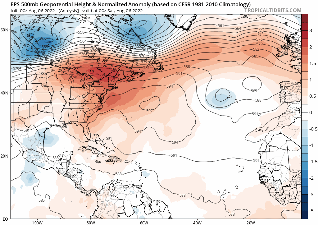
Well, just as Gray rings the bell the eps long range is trying to show a pattern change with the wave breaking going away and more favaorable pattern.

Watch loop till the end.

Image

Image
0 likes   

User avatar
hurricanetrack
HurricaneTrack.com
HurricaneTrack.com
Posts: 1774
Joined: Tue Dec 02, 2003 10:46 pm
Location: Wilmington, NC
Contact:

Re: 2022 Indicators (SSTs/SAL/MSLP/Shear/Steering/Instability) and >Day 16 Models

#2602 Postby hurricanetrack » Tue Aug 09, 2022 12:23 pm

Notice towards the end of my What's Up video for today that the period we are in right now - from a climo perspective - actually dips somewhat before we go up the ramp. That is about as close to "calm before the storm" as you can get lol.


Link: https://youtu.be/CZFlemolnjs
21 likes   

User avatar
captainbarbossa19
Category 5
Category 5
Posts: 1039
Joined: Wed Aug 21, 2019 11:09 pm
Location: Starkville, MS

Re: 2022 Indicators (SSTs/SAL/MSLP/Shear/Steering/Instability) and >Day 16 Models

#2603 Postby captainbarbossa19 » Tue Aug 09, 2022 2:08 pm

hurricanetrack wrote:Notice towards the end of my What's Up video for today that the period we are in right now - from a climo perspective - actually dips somewhat before we go up the ramp. That is about as close to "calm before the storm" as you can get lol.

https://youtu.be/CZFlemolnjs


I really enjoy watching your videos. I find your analysis to be objective concerning the different indicators and I like that you do not underplay anything or over-hype! Thank you for sharing your input.
3 likes   

User avatar
weeniepatrol
Category 3
Category 3
Posts: 857
Joined: Sat Aug 22, 2020 5:30 pm
Location: WA State

Re: 2022 Indicators (SSTs/SAL/MSLP/Shear/Steering/Instability) and >Day 16 Models

#2604 Postby weeniepatrol » Tue Aug 09, 2022 3:21 pm

Image

Across the Atlantic, the NHC continues to monitor a tropical wave in the Main Development Region (MDR) with a 30% chance of formation during the next five days. While models favor some deepening of low pressure in the near-term tied to this wave, environmental conditions are expected to become less conducive for development by this weekend, prompting no corresponding TC area for week-1 in the MDR. Later in the period, one or more easterly waves propagating over West Africa remain favored in ensemble guidance, where there is also multi-model agreement indicating Rossby wave activity and enhanced convection in the OLR anomaly fields over the tropical Atlantic. While some probabilistic TC tools are less supportive of TC potential in the MDR, a moderate confidence area is posted over the MDR for week-2, which coincides with a sharp climatological uptick in TC activity over the Atlantic by mid-August. Should the MJO show better signs or organization over the Indian Ocean later in August, this also historically favors increased chances for TC development in the Atlantic basin.
2 likes   

User avatar
Jr0d
S2K Supporter
S2K Supporter
Posts: 1173
Joined: Tue Aug 27, 2019 10:52 am
Location: Cayo Hueso

Re: 2022 Indicators (SSTs/SAL/MSLP/Shear/Steering/Instability) and >Day 16 Models

#2605 Postby Jr0d » Tue Aug 09, 2022 4:24 pm

toad strangler wrote:William Gray of CSU fame didn't just pick 8/20 out of thin air to ring his bell. Every year is different of course but that 8/20 date is pretty rock solid on when conditions seemingly flip over night from not conducive or marginally conducive to go time.


Seems like even on slow seasons just after mid August its like a switch is turned and almost overnight the MDR wakes up.

With the recent hyperactive seasons, especially early season storms a few folks have forgotten (or too young to not know any different) this "unofficial start" of hurricane season.

This is always a favorite tine of year for Florida surfers. The sea grapes rippen, school is back in session leaving the morning line ups free on most of the groms. Good times.

That said I dont does not appear we will see a true hurricane swell from a Cape Verde long track stormin the next 10 days...but its coming. You can almost feel it.
6 likes   

zzh
Category 1
Category 1
Posts: 375
Joined: Fri Aug 27, 2021 2:18 pm

Re: 2022 Indicators (SSTs/SAL/MSLP/Shear/Steering/Instability) and >Day 16 Models

#2606 Postby zzh » Tue Aug 09, 2022 11:48 pm

Image
Image
Warmer western subtropics is taking away instability from tropics while a cooler eastern subtropics/Canary Current is transporting dry air into the tropics, decreasing the instability there.
1 likes   

tolakram
Admin
Admin
Posts: 19165
Age: 60
Joined: Sun Aug 27, 2006 8:23 pm
Location: Florence, KY (name is Mark)

Re: 2022 Indicators (SSTs/SAL/MSLP/Shear/Steering/Instability) and >Day 16 Models

#2607 Postby tolakram » Wed Aug 10, 2022 6:08 am

zzh wrote:https://i.imgur.com/VbkvcJe.png
https://i.imgur.com/iXdpaRw.gif
Warmer western subtropics is taking away instability from tropics while a cooler eastern subtropics/Canary Current is transporting dry air into the tropics, decreasing the instability there.


How is that first map derived? Seems to conflict with the NOAA map

Image
0 likes   
M a r k
- - - - -
Join us in chat: Storm2K Chatroom Invite. Android and IOS apps also available.

The posts in this forum are NOT official forecasts and should not be used as such. Posts are NOT endorsed by any professional institution or STORM2K.org. For official information and forecasts, please refer to NHC and NWS products.

tolakram
Admin
Admin
Posts: 19165
Age: 60
Joined: Sun Aug 27, 2006 8:23 pm
Location: Florence, KY (name is Mark)

Re: 2022 Indicators (SSTs/SAL/MSLP/Shear/Steering/Instability) and >Day 16 Models

#2608 Postby tolakram » Wed Aug 10, 2022 6:16 am

SST's, same source

Image

2021

Image

2017

Image

2017 SSTA
Image

source: https://www.star.nesdis.noaa.gov/pub/sod/mecb/crw/data/5km/v3.1_op/image_browse/daily/

I don't know what to think about the instability thesis floating around, unless this has been a static pattern dating back decades now.
0 likes   
M a r k
- - - - -
Join us in chat: Storm2K Chatroom Invite. Android and IOS apps also available.

The posts in this forum are NOT official forecasts and should not be used as such. Posts are NOT endorsed by any professional institution or STORM2K.org. For official information and forecasts, please refer to NHC and NWS products.

User avatar
toad strangler
S2K Supporter
S2K Supporter
Posts: 4162
Joined: Sun Jul 28, 2013 3:09 pm
Location: Earth
Contact:

Re: 2022 Indicators (SSTs/SAL/MSLP/Shear/Steering/Instability) and >Day 16 Models

#2609 Postby toad strangler » Wed Aug 10, 2022 6:19 am

zzh wrote:https://i.imgur.com/VbkvcJe.png
https://i.imgur.com/iXdpaRw.gif
Warmer western subtropics is taking away instability from tropics while a cooler eastern subtropics/Canary Current is transporting dry air into the tropics, decreasing the instability there.


I don't buy this at all for the ramp up to peak season. Mark Sudduth doesn't mention it at all in his updates. I don't hear guys like Levi Cowan talking about it. I'm just not hearing it. Maybe today? Sure, it sounds plausible.
1 likes   

tolakram
Admin
Admin
Posts: 19165
Age: 60
Joined: Sun Aug 27, 2006 8:23 pm
Location: Florence, KY (name is Mark)

Re: 2022 Indicators (SSTs/SAL/MSLP/Shear/Steering/Instability) and >Day 16 Models

#2610 Postby tolakram » Wed Aug 10, 2022 6:22 am

If we want to use the instability graphic rather than the chart, most of the MDR is near normal at the moment.

Image

The chart looks like it has for the past 10+ years.

Image
1 likes   
M a r k
- - - - -
Join us in chat: Storm2K Chatroom Invite. Android and IOS apps also available.

The posts in this forum are NOT official forecasts and should not be used as such. Posts are NOT endorsed by any professional institution or STORM2K.org. For official information and forecasts, please refer to NHC and NWS products.

User avatar
Blown Away
S2K Supporter
S2K Supporter
Posts: 9861
Joined: Wed May 26, 2004 6:17 am

Re: 2022 Indicators (SSTs/SAL/MSLP/Shear/Steering/Instability) and >Day 16 Models

#2611 Postby Blown Away » Wed Aug 10, 2022 6:47 am

:uarrow:
2022 SST pattern, fast start in EPAC, and if Atl switch turns on @mid August, it's similar to 2017.
0 likes   
Hurricane Eye Experience: David 79, Irene 99, Frances 04, Jeanne 04, Wilma 05...
Hurricane Brush Experience: Andrew 92, Erin 95, Floyd 99, Matthew 16, Irma 17, Ian 22, Nicole 22…

User avatar
NDG
S2K Supporter
S2K Supporter
Posts: 14933
Joined: Sun Jul 09, 2006 10:14 pm
Location: Orlando, FL

Re: 2022 Indicators (SSTs/SAL/MSLP/Shear/Steering/Instability) and >Day 16 Models

#2612 Postby NDG » Wed Aug 10, 2022 7:34 am

tolakram wrote:If we want to use the instability graphic rather than the chart, most of the MDR is near normal at the moment.

https://i.imgur.com/8H83F7o.png

The chart looks like it has for the past 10+ years.

https://i.imgur.com/kJg6kyJ.png


Is not near normal at all, only one small spot in the eastern Atlantic near normal at best. It still shows below normal over all.

Image
0 likes   

User avatar
SFLcane
S2K Supporter
S2K Supporter
Posts: 9606
Age: 46
Joined: Sat Jun 05, 2010 1:44 pm
Location: Lake Worth Florida

Re: 2022 Indicators (SSTs/SAL/MSLP/Shear/Steering/Instability) and >Day 16 Models

#2613 Postby SFLcane » Wed Aug 10, 2022 7:34 am

Don’t know what to make of the models we’re getting closer every day to a bust I am afraid. We'll see if things flip when the MJO crosses.

Remarkably dead for now!
0 likes   

User avatar
skyline385
Category 5
Category 5
Posts: 2444
Age: 33
Joined: Wed Aug 26, 2020 11:15 pm
Location: Palm Beach County FL

2022 Indicators (SSTs/SAL/MSLP/Shear/Steering/Instability) and >Day 16 Models

#2614 Postby skyline385 » Wed Aug 10, 2022 7:37 am

zzh wrote:Image
Image
Warmer western subtropics is taking away instability from tropics while a cooler eastern subtropics/Canary Current is transporting dry air into the tropics, decreasing the instability there.

Was looking at it yesterday myself as well, the cold pool has really extended itself in the last few days while the subtropics have continued to warm up. The cold pool in particular looks even more pronounced on the NOAA Coral Reef SST maps. We will find out soon enough if it’s going to have any effect on peak season.

Image

Another feature i saw being mentioned recently is how the instability oceanic waves from the Atlantic Nina are showing up clearly now.

Image
Last edited by skyline385 on Wed Aug 10, 2022 7:37 am, edited 2 times in total.
0 likes   

User avatar
SFLcane
S2K Supporter
S2K Supporter
Posts: 9606
Age: 46
Joined: Sat Jun 05, 2010 1:44 pm
Location: Lake Worth Florida

Re: 2022 Indicators (SSTs/SAL/MSLP/Shear/Steering/Instability) and >Day 16 Models

#2615 Postby SFLcane » Wed Aug 10, 2022 7:38 am

NDG wrote:
tolakram wrote:If we want to use the instability graphic rather than the chart, most of the MDR is near normal at the moment.

https://i.imgur.com/8H83F7o.png

The chart looks like it has for the past 10+ years.

https://i.imgur.com/kJg6kyJ.png


Is not near normal at all, only one small spot in the eastern Atlantic near normal at best. It still shows below normal over all.

https://i.imgur.com/Yrjktro.jpg


That’s a big issue!
0 likes   

tolakram
Admin
Admin
Posts: 19165
Age: 60
Joined: Sun Aug 27, 2006 8:23 pm
Location: Florence, KY (name is Mark)

Re: 2022 Indicators (SSTs/SAL/MSLP/Shear/Steering/Instability) and >Day 16 Models

#2616 Postby tolakram » Wed Aug 10, 2022 7:41 am

NDG wrote:
tolakram wrote:If we want to use the instability graphic rather than the chart, most of the MDR is near normal at the moment.

https://i.imgur.com/8H83F7o.png

The chart looks like it has for the past 10+ years.

https://i.imgur.com/kJg6kyJ.png


Is not near normal at all, only one small spot in the eastern Atlantic near normal at best. It still shows below normal over all.

https://i.imgur.com/Yrjktro.jpg


There is no normal on the color chart, it will be either 2 below or 2 above. Nice arrows :) I see what you mean, I misread the green.
2 likes   
M a r k
- - - - -
Join us in chat: Storm2K Chatroom Invite. Android and IOS apps also available.

The posts in this forum are NOT official forecasts and should not be used as such. Posts are NOT endorsed by any professional institution or STORM2K.org. For official information and forecasts, please refer to NHC and NWS products.

User avatar
SFLcane
S2K Supporter
S2K Supporter
Posts: 9606
Age: 46
Joined: Sat Jun 05, 2010 1:44 pm
Location: Lake Worth Florida

Re: 2022 Indicators (SSTs/SAL/MSLP/Shear/Steering/Instability) and >Day 16 Models

#2617 Postby SFLcane » Wed Aug 10, 2022 7:43 am

skyline385 wrote:
zzh wrote:https://i.imgur.com/VbkvcJe.png
https://i.imgur.com/iXdpaRw.gif
Warmer western subtropics is taking away instability from tropics while a cooler eastern subtropics/Canary Current is transporting dry air into the tropics, decreasing the instability there.

Was looking at it yesterday myself as well, the cold pool has really extended itself in the last few days while the subtropics have continued to warm up. The cold pool in particular looks even more pronounced on the NOAA Coral Reef SST maps. We will find out soon enough if it’s going to have any effect on peak season.

https://uploads.tapatalk-cdn.com/20220810/860c2bdb43631b8ccb7bfe3407643197.jpg


Sent from my iPhone using Tapatalk


Such a weird configuration lol. It looks like September of a certain year you don't wanna see.
0 likes   

User avatar
InfernoFlameCat
Category 5
Category 5
Posts: 1966
Age: 21
Joined: Mon Dec 14, 2020 10:52 am
Location: Buford, GA

Re: 2022 Indicators (SSTs/SAL/MSLP/Shear/Steering/Instability) and >Day 16 Models

#2618 Postby InfernoFlameCat » Wed Aug 10, 2022 7:50 am

The instability over Africa, does that have any meaningful impact on the Cape Verde waves? It looks anomalously high.
0 likes   
I am by no means a professional. DO NOT look at my forecasts for official information or make decisions based on what I post.

Goal: to become a registered expert over tropical and subtropical cyclones.

User avatar
SFLcane
S2K Supporter
S2K Supporter
Posts: 9606
Age: 46
Joined: Sat Jun 05, 2010 1:44 pm
Location: Lake Worth Florida

Re: 2022 Indicators (SSTs/SAL/MSLP/Shear/Steering/Instability) and >Day 16 Models

#2619 Postby SFLcane » Wed Aug 10, 2022 8:28 am

MJO comes around August 15-20 If the models haven't really flipped in a week, and we're looking at dead til the end of August, we have a big problem.
0 likes   

tolakram
Admin
Admin
Posts: 19165
Age: 60
Joined: Sun Aug 27, 2006 8:23 pm
Location: Florence, KY (name is Mark)

Re: 2022 Indicators (SSTs/SAL/MSLP/Shear/Steering/Instability) and >Day 16 Models

#2620 Postby tolakram » Wed Aug 10, 2022 8:41 am

It's August 10th. The season was radically overhyped, as most of us recognized, and we had a CV wave that should not develop threaten to develop in early August. I don't see anything unusual yet but the clock is ticking. We are nearing peak angst.
1 likes   
M a r k
- - - - -
Join us in chat: Storm2K Chatroom Invite. Android and IOS apps also available.

The posts in this forum are NOT official forecasts and should not be used as such. Posts are NOT endorsed by any professional institution or STORM2K.org. For official information and forecasts, please refer to NHC and NWS products.


Return to “Talkin' Tropics”

Who is online

Users browsing this forum: Bing [Bot], Lizzytiz1, tolakram and 139 guests